|
Synnyr
Synnyr (russian: Сынныр) is a mountain massif in Irkutsk Oblast and Buryatia, Russian Federation. The range is part of the Baikal Rift Zone. Google Earth There is potash mining in the range at the Synnyr mine. Geography The Synnyr stretches from SW to NE for roughly between the Akitkan Range and the Upper Angara Range, west of the northwestern end of the Stanovoy Highlands, with the Patom Highlands to the north. It is limited by the valleys of the Chaya and Mama rivers. The Chuya, Kholodnaya, Tyya and Olokit have their sources in the range.Северо-Байкальское нагорье '''' in 30 vols. — Ch. ed. [...More Info...] [...Related Items...] OR: [Wikipedia] [Google] [Baidu] |
Synnyr Mine
The Synnyr mine is a large potash mine located in eastern Russia in Sakha Republic. Synnyr represents one of the largest potash reserves in Russia having estimated reserves of 500 million tonnes of ore grading 19% potassium chloride Potassium chloride (KCl, or potassium salt) is a metal halide salt composed of potassium and chlorine. It is odorless and has a white or colorless vitreous crystal appearance. The solid dissolves readily in water, and its solutions have a sa ... metal. See also * List of mines in Russia References Potash mines in Russia {{SakhaRepublic-geo-stub ... [...More Info...] [...Related Items...] OR: [Wikipedia] [Google] [Baidu] |
Chuya (river)
The Chuya (russian: Чуя), also known as Big Chuya (russian: Большая Чуя, translit=Bolshaya Chuya) in its last stretch, is a river in Buryatia and Irkutsk Oblast, Russia. It is the 13th longest tributary of the Lena and the 191st longest river in Russia, with a length of and a drainage basin area of . The Mamsko-Chuysky District of Irkutsk Oblast is named after rivers Mama and Chuya. The district's settlement of Chuya is located on the right bank of the Lena River at the confluence with the Chuya.Чуя (река в Бурятской АССР и Иркутской обл.) '''' in 30 vols. — Ch ... [...More Info...] [...Related Items...] OR: [Wikipedia] [Google] [Baidu] |
Inyaptuk Golets
Inyaptuk Golets (russian: link=no, Иняптук Голец) is a peak in the North Baikal Highlands. Administratively it is part of Buryatia, Russian Federation. Geography This high mountain is the highest point of the North Baikal Highlands, part of the South Siberian System of ranges. It is located in the southern part of the highland area, to the north of the northern end of Lake Baikal, in Severo-Baykalsky District. Google Earth River Chuya has its sources in the northern slopes of the mountain. Inyaptuk is a ‘’golets’’-type of mountain with a bald peak belonging to the Synnyr Massif, one of the subranges of the North Baikal Highlands mountain system. See also *List of mountains in Russia This is a list of mountains and hills of Russia. List by elevation Over 5000 meters 4000 to 4999 meters 3000 to 3999 meters 2000 to 2999 meters 1000 to 1999 meters Under 1000 metres See also *Highest points of Russian Federal s ... References External ... [...More Info...] [...Related Items...] OR: [Wikipedia] [Google] [Baidu] |
Akitkan Range
The Akitkan Range (russian: хребет Акиткан; zh, 阿基特坎山) is a mountain range in Irkutsk Oblast and Buryatia, Russian Federation. Google Earth The Paleoproterozoic Akitkan Orogen is named after the range. History Between 1855 and 1858 Ivan Kryzhin (d. 1884) took part in the Eastern Siberian expedition led by Russian astronomer and traveler Ludwig Schwarz. In 1857 he mapped the Kirenga River and, while exploring its right tributary, the Cherepanikha, Kryzhin discovered the formerly unknown Akitkan Range rising above the area of its source. The North Baikal Highlands, where the range rises, were explored between 1909 and 1911 by Russian geologist Pavel Preobrazhensky (1874 - 1944). He surveyed the river valley of the Chechuy, a right tributary of the Lena with its sources in the Akitkan. Overcoming numerous difficulties, Preobrazhensky managed to map for the first time a stretch of the Akitkan Range. Geography The Akitkan stretches roughly northwards ... [...More Info...] [...Related Items...] OR: [Wikipedia] [Google] [Baidu] |
North Baikal Highlands
The North Baikal Highlands ( rus, Северо-Байкальское нагорье; bua, Хойто-Байгалай хадалиг газар) '''' in 30 vols. — Ch. ed. . - 3rd ed. - M. Soviet Encyclopedia, 1969-1978.(in Russian) are a mountainous area in , Russia. Administratively the territory of the uplands is part of Buryat ... [...More Info...] [...Related Items...] OR: [Wikipedia] [Google] [Baidu] |
South Siberian System
The South Siberian Mountains ( rus, Южно-Сибирские горы) are one of the largest mountain systems of the Russian Federation. The total area of the system of mountain ranges is more than 1.5 million km². The South Siberian Mountains are located in the Siberian and Far Eastern Federal Districts of Russia, as well as partly in Mongolia. The territory of the mountain system is one of the Great Russian Regions. Geography The system is composed of a number of ranges aligned in an east–west direction stretching for almost . Part of them are near the border with Mongolia and China, while others rise further north. To the south the South Siberian ranges merge with the Mongolian and Chinese mountain chains and plateaus. In the west lies the Dzungarian Basin and to the east the Mongolian Plateau. To the north the South Siberian Mountains merge with the West Siberian Lowland and the Central Siberian Plateau, both on the Russian side. To the southeast the Baikal Range i ... [...More Info...] [...Related Items...] OR: [Wikipedia] [Google] [Baidu] |
Upper Angara Range
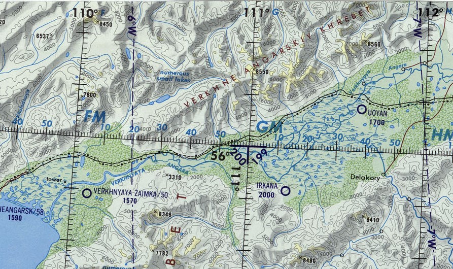
The Upper Angara Range (russian: Верхнеангарский хребет) is a mountain range in Buryatia and Irkutsk Oblast, Russia, part of the Stanovoy Highlands. Google Earth The Baikal–Amur Mainline passes at the foot of the southern side of the range. Geography The range stretches from southwest to northeast for about , from the northern end of Lake Baikal to the sources of the Mamakan river, a left tributary of the Vitim. It forms the northern limit of the Upper Angara Depression, rising above the right bank of the Upper Angara River which flows into Lake Baikal. To the east rises the Delyun-Uran, the northernmost range of the Stanovoy Highlands. The main ridge is relatively narrow, with sharp peaks, cirques and glacial troughs.Верхнеангарский хребет — '' |
Stanovoy Highlands
The Stanovoy Highlands ( rus, Станово́е наго́рье) or Stanovoy Uplands is a mountain range in the Transbaikal region of Siberia, Russia. Geography The Stanovoy Highlands are a mountainous area between the Patom Highlands to the north and the Vitim Plateau to the south. To the northeast they border with the Olyokma-Chara Plateau —in the upper reaches of the Chara river. The ranges of the highlands stretch roughly in a WSW / ENE direction between the North Baikal Highlands in the west and the Olyokma River in the east. There are large intermontane basins, such as the Muya Depression and the Chara Depression at altitudes ranging between and . Subranges The system of the Stanovoy Highlands comprises a group of subranges, including the following:Oleg Leonidovič Kryžanovskij, ''A Checklist of the Ground-beetles of Russia and Adjacent Lands.'' p. 15 *Southern Muya Range (Южно-Муйский хребет), highest point Muisky Gigant, *Northern Muya Range (С ... [...More Info...] [...Related Items...] OR: [Wikipedia] [Google] [Baidu] |
Patom Highlands
The Patom Highlands ( rus, Патомское нагорье) are a mountainous area in Eastern Siberia, Russia. Administratively most of the territory of the uplands is part of Irkutsk Oblast, with a smaller section in northern Transbaikal Krai. Google Earth There are large deposits of gold in Bodaybo and Artyomovsky. Besides these two towns, other inhabited localities of the mountain region are: Mama, Perevoz, Kropotkin, Svetly and Bolshoy Patom, Bodaybinsky District. History In 1912 there was a massacre of striking workers of the Lena Goldfields, located in the Patom Highlands between the Lena and Vitim rivers. Strikers were protesting about harsh working conditions. Soldiers of the Imperial Russian Army intervened and fired upon protesters, causing hundreds of casualties. The incident provoked wide outrage across pre-revolutionary Russia when Alexander Kerensky reported it in the Duma. The name of the highlands was first proposed by Peter Kropotkin in 1868. Geography ... [...More Info...] [...Related Items...] OR: [Wikipedia] [Google] [Baidu] |
Chaya (river)
The Chaya (russian: Чая) is a river in Buryatia and Irkutsk Oblast, Russia. It is the 26th longest tributary of the Lena, with a length of and a drainage basin area of .Чая (река, приток р. Лены) '''' in 30 vols. — Ch. ed. . - 3rd ed. - M. Soviet Encyclopedia, 1969-1978.(in Russian) The Chaya flows across Kirensky District, there are no settlements on the banks of the river. [...More Info...] [...Related Items...] OR: [Wikipedia] [Google] [Baidu] |
Russia
Russia (, , ), or the Russian Federation, is a transcontinental country spanning Eastern Europe and Northern Asia. It is the largest country in the world, with its internationally recognised territory covering , and encompassing one-eighth of Earth's inhabitable landmass. Russia extends across eleven time zones and shares land boundaries with fourteen countries, more than any other country but China. It is the world's ninth-most populous country and Europe's most populous country, with a population of 146 million people. The country's capital and largest city is Moscow, the largest city entirely within Europe. Saint Petersburg is Russia's cultural centre and second-largest city. Other major urban areas include Novosibirsk, Yekaterinburg, Nizhny Novgorod, and Kazan. The East Slavs emerged as a recognisable group in Europe between the 3rd and 8th centuries CE. Kievan Rus' arose as a state in the 9th century, and in 988, it adopted Orthodox Christianity from the ... [...More Info...] [...Related Items...] OR: [Wikipedia] [Google] [Baidu] |
Mama (river)
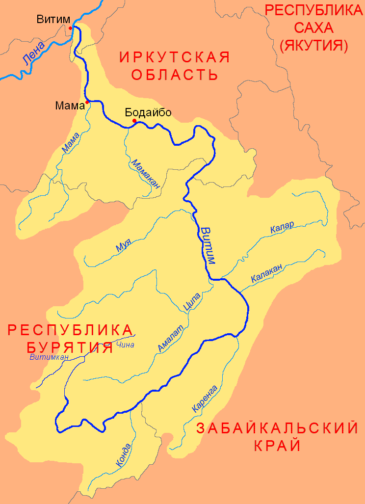
The Mama (russian: Мама) is a river in Irkutsk Oblast and Buryatia, Russia. It is a left tributary of the Vitim, the second largest in basin area after the Tsipa. The river has a length of and a drainage basin of . The total length of the river including the Left Mama is . The Mamsko-Chuysky District of Irkutsk Oblast is named after rivers Mama and Chuya. The settlements of Bramya, Slyudyanka, Lugovsky, Zarya and Mama are located by the river. Course The river basin is located on the slopes and foothills of the Upper Angara Range. Rivers Left Mama ''(Levaya Mama)'' and Right Mama ''(Pravaya Mama)'', which form the Mama river, have their sources in the heights of the range, at the first and at about the second. They are fast-flowing mountain rivers, with rapids and waterfalls. After the confluence the Mama flows roughly northeastwards across a fragmented floodplain slightly meandering among rocky banks. The river is navigable downstream from the confluence of the Br ... [...More Info...] [...Related Items...] OR: [Wikipedia] [Google] [Baidu] |


