|
Mama (river)
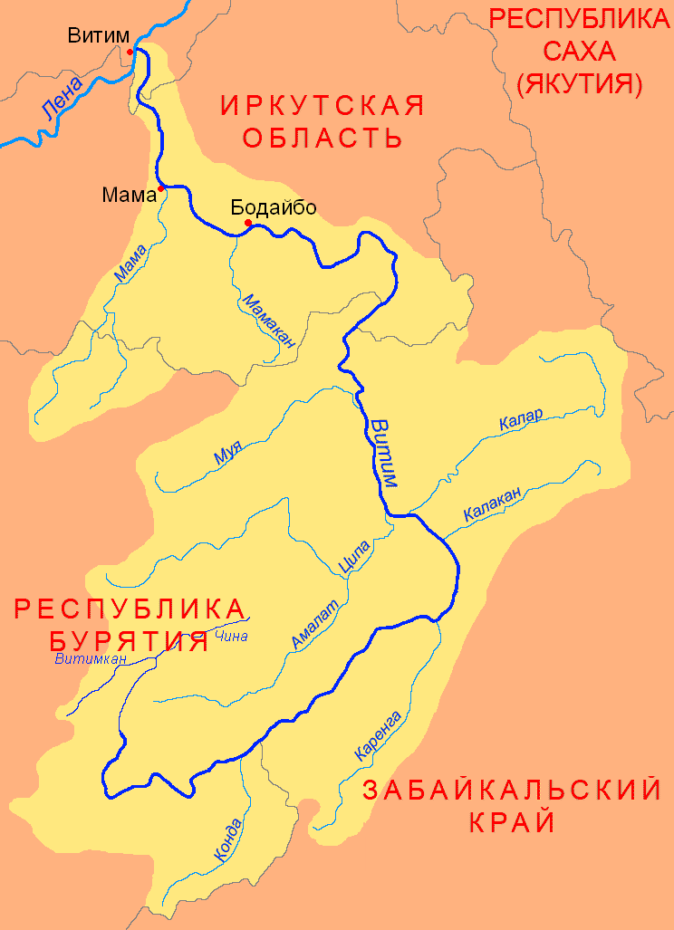
The Mama (russian: Мама) is a river in Irkutsk Oblast and Buryatia, Russia. It is a left tributary of the Vitim, the second largest in basin area after the Tsipa. The river has a length of and a drainage basin of . The total length of the river including the Left Mama is . The Mamsko-Chuysky District of Irkutsk Oblast is named after rivers Mama and Chuya. The settlements of Bramya, Slyudyanka, Lugovsky, Zarya and Mama are located by the river. Course The river basin is located on the slopes and foothills of the Upper Angara Range. Rivers Left Mama ''(Levaya Mama)'' and Right Mama ''(Pravaya Mama)'', which form the Mama river, have their sources in the heights of the range, at the first and at about the second. They are fast-flowing mountain rivers, with rapids and waterfalls. After the confluence the Mama flows roughly northeastwards across a fragmented floodplain slightly meandering among rocky banks. The river is navigable downstream from the confluence of the Bramya, a s ... [...More Info...] [...Related Items...] OR: [Wikipedia] [Google] [Baidu] |
Vitim (river)
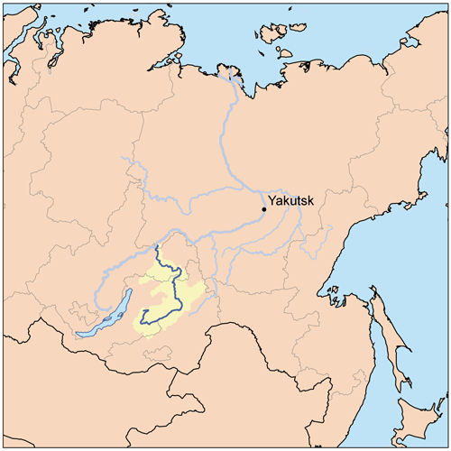
The Vitim (russian: Витим; evn, Витым, ; sah, Виитим, ; Buryat and mn, Витим, ''Vitim'') is a major tributary of the Lena. Its source is east of Lake Baikal, at the confluence of rivers Vitimkan from the west and China from the east. The Vitim flows first south, bends eastwards and then northward in the Vitim Plateau. Then it flows north through the Stanovoy Highlands and the town of Bodaybo. Including river Vitimkan, its western source, it is long, and has a drainage basin of .Витим (река в Бурят. АССР) It is navigable from the Lena to Bodaybo. Upstream, ... [...More Info...] [...Related Items...] OR: [Wikipedia] [Google] [Baidu] |
Upper Angara Range
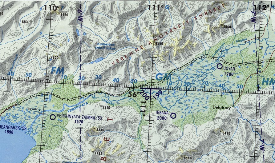
The Upper Angara Range (russian: Верхнеангарский хребет) is a mountain range in Buryatia and Irkutsk Oblast, Russia, part of the Stanovoy Highlands.Google Earth The Baikal–Amur Mainline passes at the foot of the southern side of the range. Geography The range stretches from southwest to northeast for about , from the northern end of Lake Baikal to the sources of the Mamakan river, a left tributary of the Vitim. It forms the northern limit of the Upper Angara Depression, rising above the right bank of the Upper Angara River which flows into Lake Baikal. To the east rises the Delyun-Uran, the northernmost range of the Stanovoy Highlands. The main ridge is relatively narrow, with sharp peaks, cirques and glacial troughs.Верхнеангарский хребет — '' |
Great Soviet Encyclopedia
The ''Great Soviet Encyclopedia'' (GSE; ) is one of the largest Russian-language encyclopedias, published in the Soviet Union from 1926 to 1990. After 2002, the encyclopedia's data was partially included into the later ''Bolshaya rossiyskaya entsiklopediya'' (or '' Great Russian Encyclopedia'') in an updated and revised form. The GSE claimed to be "the first Marxist–Leninist general-purpose encyclopedia". Origins The idea of the ''Great Soviet Encyclopedia'' emerged in 1923 on the initiative of Otto Schmidt, a member of the Russian Academy of Sciences. In early 1924 Schmidt worked with a group which included Mikhail Pokrovsky, (rector of the Institute of Red Professors), Nikolai Meshcheryakov (Former head of the Glavit, the State Administration of Publishing Affairs), Valery Bryusov (poet), Veniamin Kagan (mathematician) and Konstantin Kuzminsky to draw up a proposal which was agreed to in April 1924. Also involved was Anatoly Lunacharsky, People's Commissar of Education ... [...More Info...] [...Related Items...] OR: [Wikipedia] [Google] [Baidu] |
Vitim ;
{{Set index article, populated places in Russia ...
Vitim (russian: Витим) is the name of several inhabited localities in Russia. Modern localities *Vitim, Sakha Republic, an urban locality (an urban-type settlement) in Lensky District of the Sakha Republic *Vitim, Republic of Buryatia, a rural locality (a settlement) in Muysky Selsoviet of Muysky District in the Republic of Buryatia; Alternative names *Vitim, alternative name of Romanovka, a '' selo'' in Vitimsky Selsoviet of Bauntovsky District in the Republic of Buryatia Buryatia, officially the Republic of Buryatia (russian: Республика Бурятия, r=Respublika Buryatiya, p=rʲɪsˈpublʲɪkə bʊˈrʲætʲɪjə; bua, Буряад Улас, Buryaad Ulas, , mn, Буриад Улс, Buriad Uls), is ... [...More Info...] [...Related Items...] OR: [Wikipedia] [Google] [Baidu] |
Golets (geography)
Golets ( rus, голец), plural Goltsy ( rus, Гольцы), is a type of bald mountain summit of certain areas of Siberia. The term is part of the geographical name of several peaks in the region. Description ''Golets'' protrude above the treeline and are usually round or blunt. They are barren, rocky or stony, and only rarely lichens or stunted small scrubs such as Siberian pine, may grow on them. Bare rock slopes, kurums and cliffs are common. The term is usually found in the names of mountaintops in the South Siberian System, especially in Transbaikalia and the Sayan Mountains. The zone below the golets is normally the highest of the altitudinal vegetation zones, above the mountain tundra of the alpine belt.Sizykh, A. (2016) ''Formation of an Ecotone at the Boundary of Forest and Mountain Tundra—Morskoy Ridge as an Example, Middle Part of Eastern Coast of Lake Baikal.'' Open Access Library Journal, 3, 1-4. This kind of mountains may consist in single high peaks connect ... [...More Info...] [...Related Items...] OR: [Wikipedia] [Google] [Baidu] |
Siberian Pine
''Pinus sibirica'', or Siberian pine, in the family Pinaceae is a species of pine tree that occurs in Siberia from 58°E in the Ural Mountains east to 126°E in the Stanovoy Range in southern Sakha Republic, and from Igarka at 68°N in the lower Yenisei valley, south to 45°N in central Mongolia. Description ''Pinus sibirica'' is a member of the white pine group, ''Pinus'' subgenus ''Strobus'', and like all members of that group, the leaves ('needles') are in fascicles (bundles) of five, with a deciduous sheath. They are 5–10 cm long. Siberian pine cones are 5–9 cm long. The 9–12 mm long seeds have only a vestigial wing and are dispersed by spotted nutcrackers. Siberian pine is treated as a variety or subspecies of the very similar Swiss pine (''Pinus cembra'') by some botanists. It differs in having slightly larger cones, and needles with three resin canals instead of two in Swiss pine. Like other European and Asian white pines, Siberian pine is very resis ... [...More Info...] [...Related Items...] OR: [Wikipedia] [Google] [Baidu] |
Taiga
Taiga (; rus, тайга́, p=tɐjˈɡa; relates to Mongolic and Turkic languages), generally referred to in North America as a boreal forest or snow forest, is a biome characterized by coniferous forests consisting mostly of pines, spruces, and larches. The taiga or boreal forest has been called the world's largest land biome. In North America, it covers most of inland Canada, Alaska, and parts of the northern contiguous United States. In Eurasia, it covers most of Sweden, Finland, much of Russia from Karelia in the west to the Pacific Ocean (including much of Siberia), much of Norway and Estonia, some of the Scottish Highlands, some lowland/coastal areas of Iceland, and areas of northern Kazakhstan, northern Mongolia, and northern Japan (on the island of Hokkaidō). The main tree species, depending on the length of the growing season and summer temperatures, vary across the world. The taiga of North America is mostly spruce, Scandinavian and Finnish taiga consists of ... [...More Info...] [...Related Items...] OR: [Wikipedia] [Google] [Baidu] |
Larch
Larches are deciduous conifers in the genus ''Larix'', of the family Pinaceae (subfamily Laricoideae). Growing from tall, they are native to much of the cooler temperate northern hemisphere, on lowlands in the north and high on mountains further south. Larches are among the dominant plants in the boreal forests of Siberia and Canada. Although they are conifers, larches are deciduous trees that lose their needles in the autumn. Etymology The English name Larch ultimately derives from the Latin "larigna," named after the ancient settlement of Larignum. The story of its naming was preserved by Vitruvius: It is worth while to know how this wood was discovered. The divine Caesar, being with his army in the neighbourhood of the Alps, and having ordered the towns to furnish supplies, the inhabitants of a fortified stronghold there, called Larignum, trusting in the natural strength of their defences, refused to obey his command. So the general ordered his forces to the assault. In ... [...More Info...] [...Related Items...] OR: [Wikipedia] [Google] [Baidu] |
Permafrost
Permafrost is ground that continuously remains below 0 °C (32 °F) for two or more years, located on land or under the ocean. Most common in the Northern Hemisphere, around 15% of the Northern Hemisphere or 11% of the global surface is underlain by permafrost, with the total area of around 18 million km2. This includes substantial areas of Alaska, Greenland, Canada and Siberia. It can also be located on mountaintops in the Southern Hemisphere and beneath ice-free areas in the Antarctic. Permafrost does not have to be the first layer that is on the ground. It can be from an inch to several miles deep under the Earth's surface. It frequently occurs in ground ice, but it can also be present in non-porous bedrock. Permafrost is formed from ice holding various types of soil, sand, and rock in combination. Permafrost contains large amounts of biomass and decomposed biomass that has been stored as methane and carbon dioxide, making tundra soil a carbon sink. As global war ... [...More Info...] [...Related Items...] OR: [Wikipedia] [Google] [Baidu] |
Meandering
A meander is one of a series of regular sinuous curves in the channel of a river or other watercourse. It is produced as a watercourse erodes the sediments of an outer, concave bank (cut bank) and deposits sediments on an inner, convex bank which is typically a point bar. The result of this coupled erosion and sedimentation is the formation of a sinuous course as the channel migrates back and forth across the axis of a floodplain. The zone within which a meandering stream periodically shifts its channel is known as a meander belt. It typically ranges from 15 to 18 times the width of the channel. Over time, meanders migrate downstream, sometimes in such a short time as to create civil engineering challenges for local municipalities attempting to maintain stable roads and bridges.Neuendorf, K.K.E., J.P. Mehl Jr., and J.A. Jackson, J.A., eds. (2005) ''Glossary of Geology'' (5th ed.). Alexandria, Virginia, American Geological Institute. 779 pp. Charlton, R., 2007. ''Fundamentals o ... [...More Info...] [...Related Items...] OR: [Wikipedia] [Google] [Baidu] |
Floodplain
A floodplain or flood plain or bottomlands is an area of land adjacent to a river which stretches from the banks of its channel to the base of the enclosing valley walls, and which experiences flooding during periods of high discharge.Goudie, A. S., 2004, ''Encyclopedia of Geomorphology'', vol. 1. Routledge, New York. The soils usually consist of clays, silts, sands, and gravels deposited during floods. Because the regular flooding of floodplains can deposit nutrients and water, floodplains frequently have high soil fertility; some important agricultural regions, such as the Mississippi river basin and the Nile, rely heavily on the flood plains. Agricultural regions as well as urban areas have developed near or on floodplains to take advantage of the rich soil and fresh water. However, the risk of flooding has led to increasing efforts to control flooding. Formation Most floodplains are formed by deposition on the inside of river meanders and by overbank flow. Whereve ... [...More Info...] [...Related Items...] OR: [Wikipedia] [Google] [Baidu] |
Rapids
Rapids are sections of a river where the river bed has a relatively steep gradient, causing an increase in water velocity and turbulence. Rapids are hydrological features between a ''run'' (a smoothly flowing part of a stream) and a ''cascade''. Rapids are characterized by the river becoming shallower with some rocks exposed above the flow surface. As flowing water splashes over and around the rocks, air bubbles become mixed in with it and portions of the surface acquire a white color, forming what is called "whitewater". Rapids occur where the bed material is highly resistant to the erosive power of the stream in comparison with the bed downstream of the rapids. Very young streams flowing across solid rock may be rapids for much of their length. Rapids cause water aeration of the stream or river, resulting in better water quality. Rapids are categorized in classes, generally running from I to VI. A Class 5 rapid may be categorized as Class 5.1-5.9. While Class I rapids are eas ... [...More Info...] [...Related Items...] OR: [Wikipedia] [Google] [Baidu] |


