|
Swallows Wood
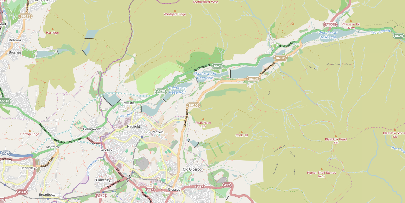
Swallows Wood is a nature reserve near Hollingworth, Tameside, straddling the border between Greater Manchester and north Derbyshire. The reserve, which contains semi-natural woodlands, meadows, ponds and marsh areas, is owned by United Utilities who are responsible for its management. The site was formerly occupied by the Hollingworth and Waste Lodge reservoirs; these were demolished in 1987, and the nature reserve was installed in their place. Arnfield Reservoir, the lowest of the Longdendale Chain reservoirs, is nearby. The route of the proposed Longdendale Bypass would pass through the nature reserve and there is an ongoing campaign to save the wood. Although the bypass has been threatening the wood for nearly 30 years Tameside Council have recently committed to planting 10,000 managed trees, in an attempt to move the woodland gradually away from the bypass route. The wood is on the fringes of the Peak District National Park Peak or The Peak may refer to: Basic meanings Geo ... [...More Info...] [...Related Items...] OR: [Wikipedia] [Google] [Baidu] |
Swallows Wood - Geograph
The swallows, martins, and saw-wings, or Hirundinidae, are a family of passerine songbirds found around the world on all continents, including occasionally in Antarctica. Highly adapted to aerial feeding, they have a distinctive appearance. The term "swallow" is used colloquially in Europe as a synonym for the barn swallow. Around 90 species of Hirundinidae are known, divided into 19 genera, with the greatest diversity found in Africa, which is also thought to be where they evolved as hole-nesters. They also occur on a number of oceanic islands. A number of European and North American species are long-distance migrants; by contrast, the West and South African swallows are nonmigratory. This family comprises two subfamilies: Pseudochelidoninae (the river martins of the genus ''Pseudochelidon'') and Hirundininae (all other swallows, martins, and saw-wings). In the Old World, the name "martin" tends to be used for the squarer-tailed species, and the name "swallow" for the more fork ... [...More Info...] [...Related Items...] OR: [Wikipedia] [Google] [Baidu] |
Hollingworth
Hollingworth is a village in the Metropolitan Borough of Tameside, in Greater Manchester, England. It is about 11 miles (19 km) east of Manchester on the Derbyshire border near Glossop. Historically part of Cheshire, it gave its name to a family who owned much of the surrounding area from before the time of the Norman conquest. History Toponymy Hollingworth was recorded ''Holisvrde'' before 1059 and in 1086. Its name is derived from the Old English ''holegn,'' for holly and ''worð'' an enclosure. In 1059, Hollingworth was surrounded by dense forests. Early history An ancient pagan religious site known as Wedneshough Green was in Hollingworth. A grassy knoll opposite the Gunn Inn was anciently called ''Wedenshaw'' or ''Woden's Hawe'' after the pagan god Woden. The region was populated by Celts, the Pecsaetans a southern branch of the Brigantes. The group became a distinct ethnic tribe in the Mercian Kingdom of the West Angles. The tribes living in the Longdendale valley ... [...More Info...] [...Related Items...] OR: [Wikipedia] [Google] [Baidu] |
Tameside
The Metropolitan Borough of Tameside is a metropolitan borough of Greater Manchester in England. It is named after the River Tame, Greater Manchester, River Tame, which flows through the borough, and includes the towns of Ashton-under-Lyne, Audenshaw, Denton, Greater Manchester, Denton, Droylsden, Dukinfield, Hyde, Greater Manchester, Hyde, Mossley and Stalybridge. Its western border is approximately east of Manchester city centre. Tameside is bordered by the metropolitan boroughs of Metropolitan Borough of Stockport, Stockport and Metropolitan Borough of Oldham, Oldham to the south and north respectively, the city of Manchester to the west and the borough of High Peak, Derbyshire, High Peak in Derbyshire to the east across Longdendale. the overall population was 219,324. It is also the 8th-most populous borough of Greater Manchester by population. The history of the area extends back to the Stone Age. There are over 300 listed buildings in Tameside and three Scheduled Ancien ... [...More Info...] [...Related Items...] OR: [Wikipedia] [Google] [Baidu] |
Greater Manchester
Greater Manchester is a metropolitan county and combined authority, combined authority area in North West England, with a population of 2.8 million; comprising ten metropolitan boroughs: City of Manchester, Manchester, City of Salford, Salford, Metropolitan Borough of Bolton, Bolton, Metropolitan Borough of Bury, Bury, Metropolitan Borough of Oldham, Oldham, Metropolitan Borough of Rochdale, Rochdale, Metropolitan Borough of Stockport, Stockport, Tameside, Trafford and Metropolitan Borough of Wigan, Wigan. The county was created on 1 April 1974, as a result of the Local Government Act 1972, and designated a functional Manchester City Region, city region on 1 April 2011. Greater Manchester is formed of parts of the Historic counties of England, historic counties of Cheshire, Lancashire and the West Riding of Yorkshire. Greater Manchester spans , which roughly covers the territory of the Greater Manchester Built-up Area, the List of urban areas in the United Kingdom, second most ... [...More Info...] [...Related Items...] OR: [Wikipedia] [Google] [Baidu] |
Derbyshire
Derbyshire ( ) is a ceremonial county in the East Midlands, England. It includes much of the Peak District National Park, the southern end of the Pennine range of hills and part of the National Forest. It borders Greater Manchester to the north-west, West Yorkshire to the north, South Yorkshire to the north-east, Nottinghamshire to the east, Leicestershire to the south-east, Staffordshire to the west and south-west and Cheshire to the west. Kinder Scout, at , is the highest point and Trent Meadows, where the River Trent leaves Derbyshire, the lowest at . The north–south River Derwent is the longest river at . In 2003, the Ordnance Survey named Church Flatts Farm at Coton in the Elms, near Swadlincote, as Britain's furthest point from the sea. Derby is a unitary authority area, but remains part of the ceremonial county. The county was a lot larger than its present coverage, it once extended to the boundaries of the City of Sheffield district in South Yorkshire where it cov ... [...More Info...] [...Related Items...] OR: [Wikipedia] [Google] [Baidu] |
United Utilities
United Utilities Group plc (UU), the United Kingdom's largest listed water company, was founded in 1995 as a result of the merger of North West Water and NORWEB. The group manages the regulated water and waste water network in North West England, which includes Cumbria, Greater Manchester, Lancashire, Merseyside, most of Cheshire and a small area of Derbyshire, which have a combined population of more than seven million. The United Utilities Group was the electricity distribution network operator for the North West until 2010, when its electricity subsidiary was sold to Electricity North West. United Utilities' headquarters are in Warrington, England, and the company has more than 5,000 direct employees. Its shares are listed on the London Stock Exchange and it is a constituent the FTSE 100 Index. North West England is the wettest region in England, and water hardness across the region is soft to very soft. History In 1989 the North West Water Authority, which was responsible ... [...More Info...] [...Related Items...] OR: [Wikipedia] [Google] [Baidu] |
Hollingworth Reservoir
Hollingworth Reservoir is a former reservoir near Hollingworth, Tameside, Greater Manchester. The reservoir straddles the Greater Manchester–Derbyshire border. It was constructed in 1854 as part of the Longdendale Chain, but was abandoned in 1987 and now forms part of the Swallows Wood nature reserve. See also * * Bottoms Reservoir ( ...[...More Info...] [...Related Items...] OR: [Wikipedia] [Google] [Baidu] |
Arnfield Reservoir
Arnfield Reservoir is a man-made lake in Longdendale in north Derbyshire. It was constructed in 1854 as part of the Longdendale chain to supply water from the River Etherow to the urban areas of Greater Manchester. Unlike the other reservoirs in the chain, Arnfield and are not in the Etherow valley but lie in the valley of tributary brooks to the north and above (Arnfield lies around 1 mile from [...More Info...] [...Related Items...] OR: [Wikipedia] [Google] [Baidu] |
Longdendale Chain
The Longdendale Chain is a sequence of six reservoirs on the River Etherow in the Longdendale Valley, in northern Derbyshire. They were constructed between 1848 and 1884 to a design by John Frederick Bateman to supply the growing population of Manchester and Salford with fresh water. The top three reservoirs (Woodhead, Torside and Rhodeswood) and Arnfield are for drinking water, and the lower reservoirs (Valehouse and Bottoms) are used as compensation reservoirs to maintain the downstream flow of the river. There was originally a seventh – Hollingworth Reservoir – which was abandoned in 1990, and has become part of the Swallows Wood nature reserve. p. 120. Water flowed by gravity through the Mottram Tunnel to the Godley covered reservoir where it drops to the service reservoirs at Denton, Audenshaw, Gorton and Prestwich. Reservoirs The reservoirs are listed from upstream to downstream i.e. from east to west: * Woodhead Reservoir * Torside Reservoir * Rhodeswood ... [...More Info...] [...Related Items...] OR: [Wikipedia] [Google] [Baidu] |
Longdendale Bypass
The Longdendale Bypass (also known as the A57/A628 Mottram-in-Longdendale, Hollingworth & Tintwistle Bypass) is a long-planned road scheme in England by the Highways Agency. The aim is to alleviate traffic congestion on the A57 road/A628 road/ A616 road routes that presently pass through the villages. There is both support and opposition for this long-planned scheme which will pass through the valley of Longdendale and part of the Peak District National Park. After nearly fifty years, part of the road scheme – the Mottram Bypass and Glossop Spur – was approved by the Highways Agency on 2 December 2014. Background The existing A628 trunk road connects the M67 from Manchester to the M1 in South Yorkshire. A single-carriageway road through the villages of Mottram in Longdendale, Hollingworth and Tintwistle and through the Peak District National Park, it is used by a relatively large number of heavy goods vehicles. Supporters of the scheme say that the A628 is one ... [...More Info...] [...Related Items...] OR: [Wikipedia] [Google] [Baidu] |
Peak District National Park
Peak or The Peak may refer to: Basic meanings Geology * Mountain peak ** Pyramidal peak, a mountaintop that has been sculpted by erosion to form a point Mathematics * Peak hour or rush hour, in traffic congestion * Peak (geometry), an (''n''-3)-dimensional element of a polytope * Peak electricity demand or peak usage * Peak-to-peak, the highest (or sometimes the highest and lowest) points on a varying waveform * Peak (pharmacology), the time at which a drug reaches its maximum plasma concentration * Peak experience, psychological term for a euphoric mental state Resource production In terms of resource production, the peak is the moment when the production of a resource reaches a maximum level, after which it declines; in particular see: * Peak oil * Peak car * Peak coal * Peak copper * Peak farmland * Peak gas * Peak gold * Peak minerals * Peak phosphorus * Peak uranium * Peak water * Peak wheat * Peak wood Other basic meanings * Visor, a part of a hat, known as a "peak" in Briti ... [...More Info...] [...Related Items...] OR: [Wikipedia] [Google] [Baidu] |


