|
Suchowola
Suchowola (; lt, Suchovola, be, Сухаволя ''Suchavolja'') is a town in north-eastern Poland in Sokółka County, located on both banks of the Olszanka River. It is situated in the Podlaskie Voivodeship (since 1999), having previously been in the Białystok Voivodeship (1975-1998). Its population is 2,196 (2017). History Suchowola was founded in the 16th century and in 1777 it was granted town rights. It is a former Polish royal town. In 1775, royal astronomer Szymon Antoni Sobiekrajski published a report in which he stated that Suchowola is the exact geographic centre of Europe. During the Polish–Soviet War, the invading Soviets murdered five Poles in Suchowola on August 9, 1920. Following the joint German-Soviet invasion of Poland, which started World War II in September 1939, the town was initially occupied by the Soviet Union. At the beginning of the war, the town's population was about 3,000, about 1,500 of whom were Jewish. Several Poles who worked or lived in ... [...More Info...] [...Related Items...] OR: [Wikipedia] [Google] [Baidu] |
Gmina Suchowola
__NOTOC__ Gmina Suchowola is an urban-rural gmina (administrative district) in Sokółka County, Podlaskie Voivodeship, in north-eastern Poland. Its seat is the town of Suchowola, which lies approximately north-west of Sokółka and north of the regional capital Białystok. The gmina covers an area of , and as of 2006 its total population is 7,350 (out of which the population of Suchowola amounts to 2,243, and the population of the rural part of the gmina is 5,107). Villages Apart from the town of Suchowola, Gmina Suchowola contains the villages and settlements of Bachmackie Kolonie, Brukowo, Chlewisk Dolny, Chlewisk Górny, Chmielniki, Podlaskie Voivodeship, Chmielniki, Chmielówka, Podlaskie Voivodeship, Chmielówka, Chodorówka Nowa, Chodorówka Stara, Chodorówka Stara-Kolonia, Ciemne, Podlaskie Voivodeship, Ciemne, Czerwonka, Sokółka County, Czerwonka, Domuraty, Dryga, Dryga-Kolonia, Dubasiewskie Kolonie, Dubasiewszczyzna, Głęboczyzna, Grodzisk, Sokółka County, Grodzi ... [...More Info...] [...Related Items...] OR: [Wikipedia] [Google] [Baidu] |
Geographic Centre Of Europe
The location of the geographical centre of Europe depends on the definition of the borders of Europe, mainly whether remote islands are included to define the extreme points of Europe, and on the method of calculating the final result. Thus, several places claim to host this hypothetical centre. Current claimants Locations currently vying for the distinction of being the centre of Europe include: * the village of Kremnické Bane or the neighbouring village Krahule, near Kremnica, in central Slovakia * the small town of Rakhiv, or the village of Dilove near Rakhiv, in western Ukraine * the village of Girija, near Vilnius, in Lithuania * a point on the island of Saaremaa in Estonia * a point near Polotsk, or in Vitebsk, or near Babruysk, or near lake Sho in Belarus * a point near the town of Tállya, in north-eastern Hungary Extreme points of Europe History of claims Poland The first official declaration of the Centre of Europe was made in 1775 by the Polish royal a ... [...More Info...] [...Related Items...] OR: [Wikipedia] [Google] [Baidu] |
Sokółka County
__NOTOC__ Sokółka County ( pl, powiat sokólski) is a unit of territorial administration and local government (powiat) in Podlaskie Voivodeship, north-eastern Poland, on the border with Belarus. It was created on 1 January 1999 as a result of the Polish local government reforms passed in 1998. Its administrative seat and largest town is Sokółka, which lies north-east of the regional capital Białystok. The county also contains the towns of Dąbrowa Białostocka, lying north of Sokółka, Krynki, lying south-east of Sokółka, and Suchowola, north-west of Sokółka. The county covers an area of . As of 2019 its total population is 67,055, out of which the population of Sokółka is 18,134, that of Dąbrowa Białostocka is 5,520, that of Krynki is 2,405, that of Suchowola is 2,183, and the rural population is 38,813. Neighbouring counties Sokółka County is bordered by Białystok County to the south-west, Mońki County to the west and Augustów County to the north-west. It ... [...More Info...] [...Related Items...] OR: [Wikipedia] [Google] [Baidu] |
Voivodeship Road
According to classes and categories of public roads in Poland, a voivodeship road ( pl, droga wojewódzka) is a category of roads one step below national roads in importance. The roads are numbered from 100 to 993. Total length of voivodeship roads in Poland is of which are unpaved (2008).Transport – activity results in 2008 , List of voivodeship roads Current list of voivodeship roads has been established with regulation of General Director of National Roads and Motorways from 2 December 2008[...More Info...] [...Related Items...] OR: [Wikipedia] [Google] [Baidu] |
Podlaskie Voivodeship
Podlaskie Voivodeship or Podlasie Province ( pl, Województwo podlaskie, ) is a voivodeship (province) in northeastern Poland. The name of the province and its territory correspond to the historic region of Podlachia. The capital and largest city is Białystok. It borders on Masovian Voivodeship to the west, Warmian-Masurian Voivodeship to the northwest, Lublin Voivodeship to the south, the Belarusian oblasts of Grodno and Brest to the east, the Lithuanian Counties of Alytus and Marijampolė to the northeast, and the Kaliningrad Oblast of Russia to the north. The province was created on 1 January 1999, pursuant to the Polish local government reforms adopted in 1998, from the former Białystok and Łomża Voivodeships and the eastern half of the former Suwałki Voivodeship. Etymology The voivodeship takes its name from the historic region of Poland called ''Podlasie'', or in Latin known as Podlachia. There are two opinions regarding the origin of the region's name. People ... [...More Info...] [...Related Items...] OR: [Wikipedia] [Google] [Baidu] |
Voivodeships Of Poland
A voivodeship (; pl, województwo ; plural: ) is the highest-level administrative division of Poland, corresponding to a province in many other countries. The term has been in use since the 14th century and is commonly translated into English as "province". The Polish local government reforms adopted in 1998, which went into effect on 1 January 1999, created sixteen new voivodeships. These replaced the 49 former voivodeships that had existed from 1 July 1975, and bear a greater resemblance (in territory, but not in name) to the voivodeships that existed between 1950 and 1975. Today's voivodeships are mostly named after historical and geographical regions, while those prior to 1998 generally took their names from the cities on which they were centered. The new units range in area from under (Opole Voivodeship) to over (Masovian Voivodeship), and in population from nearly one million (Opole Voivodeship) to over five million (Masovian Voivodeship). Administrative authority at th ... [...More Info...] [...Related Items...] OR: [Wikipedia] [Google] [Baidu] |
Poles
Poles,, ; singular masculine: ''Polak'', singular feminine: ''Polka'' or Polish people, are a West Slavic nation and ethnic group, who share a common history, culture, the Polish language and are identified with the country of Poland in Central Europe. The preamble to the Constitution of the Republic of Poland defines the Polish nation as comprising all the citizens of Poland, regardless of heritage or ethnicity. The majority of Poles adhere to Roman Catholicism. The population of self-declared Poles in Poland is estimated at 37,394,000 out of an overall population of 38,512,000 (based on the 2011 census), of whom 36,522,000 declared Polish alone. A wide-ranging Polish diaspora (the '' Polonia'') exists throughout Europe, the Americas, and in Australasia. Today, the largest urban concentrations of Poles are within the Warsaw and Silesian metropolitan areas. Ethnic Poles are considered to be the descendants of the ancient West Slavic Lechites and other tribes that inhabi ... [...More Info...] [...Related Items...] OR: [Wikipedia] [Google] [Baidu] |
Museum Of Independence
The Museum of Independence ( pl, Muzeum Niepodległości) is a museum in Warsaw, Poland. It was established on 30 January 1990 as the Museum of the History of Polish Independence and Social Movements and is located in the former Przebendowski Palace at al. 'Solidarity' 62, but it also has these branches: * X Pavilion Museum at the Warsaw Citadel * Museum of Pawiak Prison * Mausoleum of Struggle and Martyrdom The headquarters of the museum was established by the Ministry of Culture and Art in the Przebendowski Palace, which had previously housed the Museum of Vladimir Lenin (1955–1989). The museum covers the history of Polish battles and aspirations for independence from the Kościuszko Uprising to the modern day. In 1991, the facility received its current name. In 1992, the Museum of Independence received the status of a National Cultural Institution. From 1990 to 2009 the director was Andrzej Stawarz. Currently the director of the facility is T. Skoczek. References Ex ... [...More Info...] [...Related Items...] OR: [Wikipedia] [Google] [Baidu] |
Invasion Of Poland
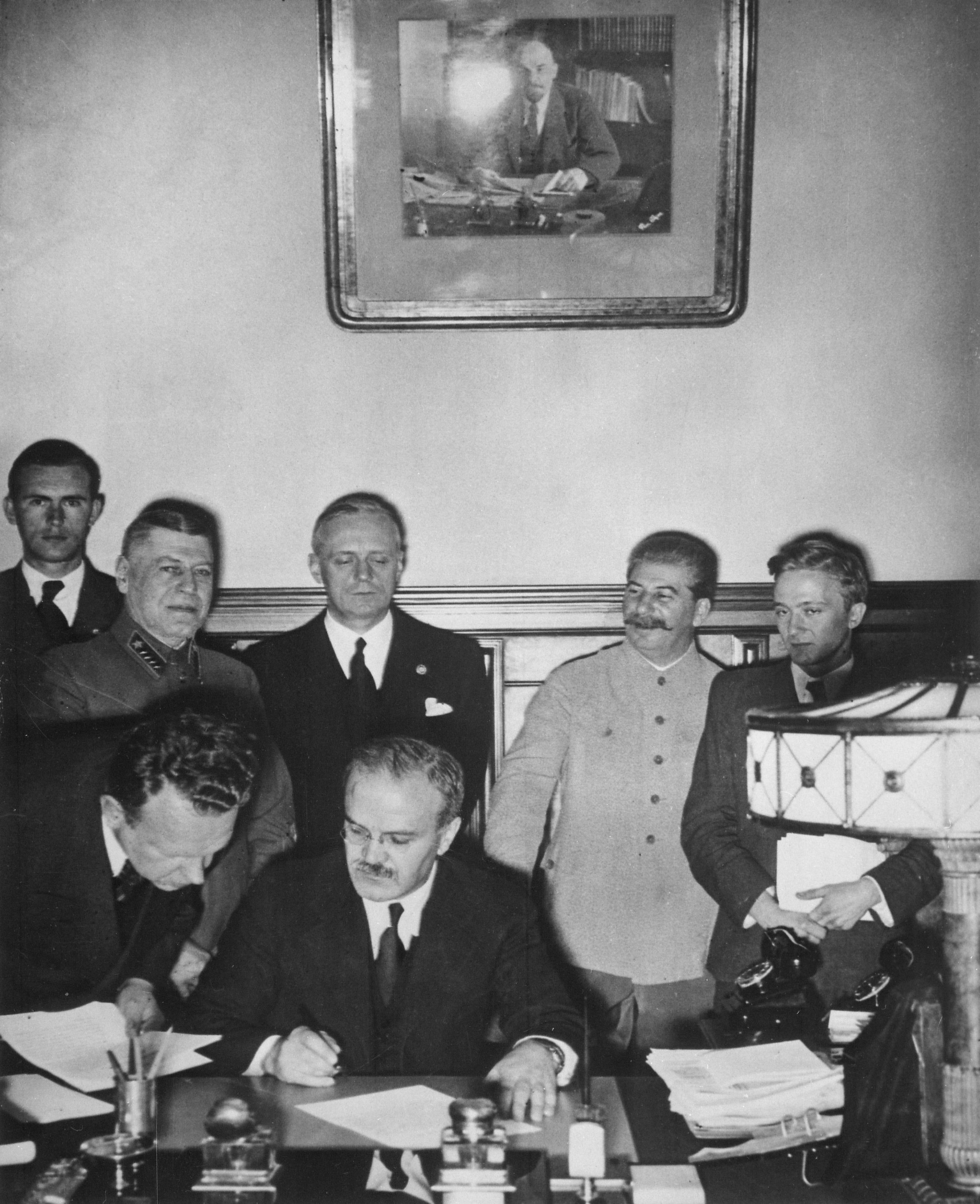
The invasion of Poland (1 September – 6 October 1939) was a joint attack on the Republic of Poland by Nazi Germany and the Soviet Union which marked the beginning of World War II. The German invasion began on 1 September 1939, one week after the signing of the Molotov–Ribbentrop Pact between Germany and the Soviet Union, and one day after the Supreme Soviet of the Soviet Union had approved the pact. The Soviets invaded Poland on 17 September. The campaign ended on 6 October with Germany and the Soviet Union dividing and annexing the whole of Poland under the terms of the German–Soviet Frontier Treaty. The invasion is also known in Poland as the September campaign ( pl, kampania wrześniowa) or 1939 defensive war ( pl, wojna obronna 1939 roku, links=no) and known in Germany as the Poland campaign (german: Überfall auf Polen, Polenfeldzug). German forces invaded Poland from the north, south, and west the morning after the Gleiwitz incident. Slovak military forces ad ... [...More Info...] [...Related Items...] OR: [Wikipedia] [Google] [Baidu] |
World War II
World War II or the Second World War, often abbreviated as WWII or WW2, was a world war that lasted from 1939 to 1945. It involved the vast majority of the world's countries—including all of the great powers—forming two opposing military alliances: the Allies and the Axis powers. World War II was a total war that directly involved more than 100 million personnel from more than 30 countries. The major participants in the war threw their entire economic, industrial, and scientific capabilities behind the war effort, blurring the distinction between civilian and military resources. Aircraft played a major role in the conflict, enabling the strategic bombing of population centres and deploying the only two nuclear weapons ever used in war. World War II was by far the deadliest conflict in human history; it resulted in 70 to 85 million fatalities, mostly among civilians. Tens of millions died due to genocides (including the Holocaust), starvation, ma ... [...More Info...] [...Related Items...] OR: [Wikipedia] [Google] [Baidu] |
Soviet Union
The Soviet Union,. officially the Union of Soviet Socialist Republics. (USSR),. was a transcontinental country that spanned much of Eurasia from 1922 to 1991. A flagship communist state, it was nominally a federal union of fifteen national republics; in practice, both its government and its economy were highly centralized until its final years. It was a one-party state governed by the Communist Party of the Soviet Union, with the city of Moscow serving as its capital as well as that of its largest and most populous republic: the Russian SFSR. Other major cities included Leningrad (Russian SFSR), Kiev (Ukrainian SSR), Minsk ( Byelorussian SSR), Tashkent (Uzbek SSR), Alma-Ata (Kazakh SSR), and Novosibirsk (Russian SFSR). It was the largest country in the world, covering over and spanning eleven time zones. The country's roots lay in the October Revolution of 1917, when the Bolsheviks, under the leadership of Vladimir Lenin, overthrew the Russian Provisional Government ... [...More Info...] [...Related Items...] OR: [Wikipedia] [Google] [Baidu] |
Occupation Of Poland (1939–1945)
The occupation of Poland by Nazi Germany and the Soviet Union during World War II (1939–1945) began with the German-Soviet invasion of Poland in September 1939, and it was formally concluded with the defeat of Germany by the Allies in May 1945. Throughout the entire course of the occupation, the territory of Poland was divided between Nazi Germany and the Soviet Union (USSR) both of which intended to eradicate Poland's culture and subjugate its people. In the summer-autumn of 1941, the lands which were annexed by the Soviets were overrun by Germany in the course of the initially successful German attack on the USSR. After a few years of fighting, the Red Army drove the German forces out of the USSR and crossed into Poland from the rest of Central and Eastern Europe. Sociologist Tadeusz Piotrowski argues that both occupying powers were hostile to the existence of Poland's sovereignty, people, and the culture and aimed to destroy them. Before Operation Barbarossa, German ... [...More Info...] [...Related Items...] OR: [Wikipedia] [Google] [Baidu] |


