|
Stronend
Stronend (511 m) is the highest peak of the Fintry Hills in Stirlingshire, Scotland. Standing above the village of Fintry, it provides excellent views of Loch Lomond Loch Lomond (; ) is a freshwater Scottish loch which crosses the Highland Boundary Fault (HBF), often considered the boundary between the lowlands of Central Scotland and the Highlands.Tom Weir. ''The Scottish Lochs''. pp. 33-43. Published by ... and The Trossachs to the north. References Mountains and hills of Stirling (council area) Marilyns of Scotland Hills of the Scottish Midland Valley {{Scotland-geo-stub ... [...More Info...] [...Related Items...] OR: [Wikipedia] [Google] [Baidu] |
Fintry Hills
The Fintry Hills form the western end of a range of hills which stretch west from the city of Stirling, Scotland. They culminate in the peak of Stronend, which overlooks Strathendrick and the village of Fintry. The northern, western and southern sides of the hills are defined by a steep and craggy escarpment, whilst the eastern sides run more gently down into the valley of the Backside Burn and Endrick Water. The Boquhan Burn, which runs initially northeastwards, drops over the northern scarp at the Spout of Ballochleam. Loch Walton lies at the foot of the hills’ southern slopes. Geology Like the neighbouring Gargunnock Hills they are composed of volcanic rocks, mainly basaltic lavas and tuffs erupted during the Chadian to Asbian substages of the Carboniferous period. The igneous rocks are named as the Clyde Plateau Volcanic Formation, itself a part of the Strathclyde Group. In stratigraphical succession i.e. youngest/uppermost at top, the individual members (subdivisions ... [...More Info...] [...Related Items...] OR: [Wikipedia] [Google] [Baidu] |
Marilyn (hill)
This is a list of Marilyn hills and mountains in the United Kingdom, Republic of Ireland, Ireland and surrounding islands and Stack (geology), sea stacks. Lists of mountains and hills in the British Isles#Marilyns, Marilyns are defined as peaks with a topographic prominence, prominence of or more, regardless of height or any other merit (e.g. topographic isolation, as used in Lists of mountains and hills in the British Isles#Munros, Munros). Thus, Marilyns can be mountains, with a height above , or relatively small hills. there were 2,010 recorded Marilyns. Definition The Marilyn classification was created by Alan Dawson in his 1992 book ''The Relative Hills of Britain''. The name Marilyn was coined by Dawson as a punning contrast to the ''Munro'' classification of Scottish mountains above , but which has no explicit prominence threshold, being homophone, homophonous with (Marilyn) ''Marilyn Monroe, Monroe''. The list of Marilyns was extended to Ireland by Clem Clements. Ma ... [...More Info...] [...Related Items...] OR: [Wikipedia] [Google] [Baidu] |
Fintry
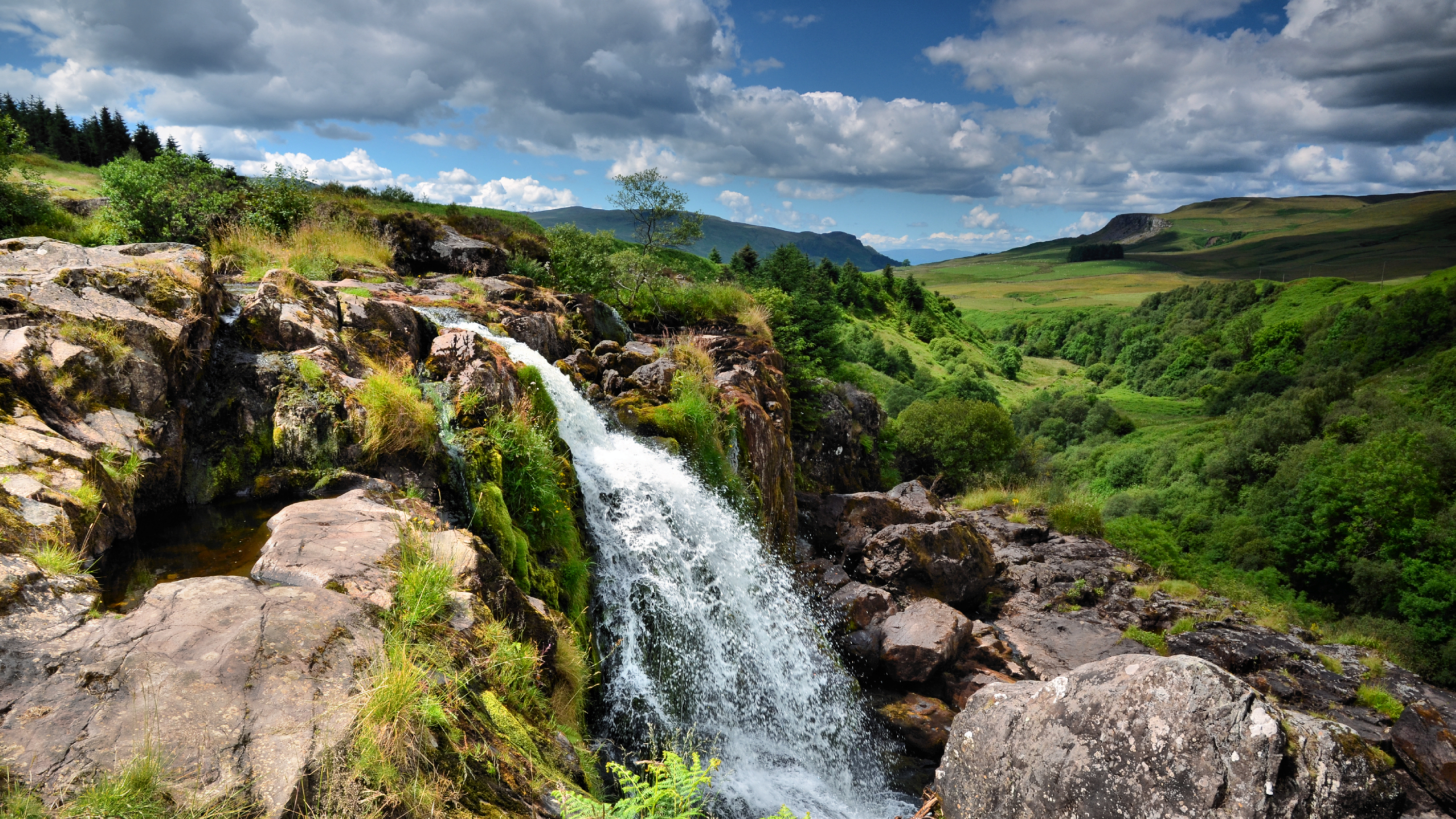
Fintry is a small riverside village in Stirlingshire, central Scotland. It is located south-west of Stirling and around north of Glasgow. Landscape The village of Fintry sits by the Endrick Water in a strath between the Campsie Fells and the Fintry Hills. The village of Fintry is overlooked by Stronend, the culmination of the Fintry Hills, which forms the western end of a range of hills which stretch east to the city of Stirling, Scotland. The Loup of Fintry, is a notable 94ft waterfall on the Endrick Water around 2 miles to the east of a Fintry. This is best seen after prolonged rain or snowfall. The total height of the waterfalls is 28.6 m (94 ft). ''Lowp'' or "Loup" means leap in Scots language, Scots. Preservation Local Landscape Area (LLA) The name Fintry is said to have derived from the Old Gaelic for "Fair Land" and is designated as a Local landscape designation, Local Landscape Area (LLA) (formally called a Special Landscape Area or Area of Great Landsc ... [...More Info...] [...Related Items...] OR: [Wikipedia] [Google] [Baidu] |
Marilyns Of Scotland
This is a list of Marilyn hills and mountains in the United Kingdom, Ireland and surrounding islands and sea stacks. Marilyns are defined as peaks with a prominence of or more, regardless of height or any other merit (e.g. topographic isolation, as used in Munros). Thus, Marilyns can be mountains, with a height above , or relatively small hills. there were 2,010 recorded Marilyns. Definition The Marilyn classification was created by Alan Dawson in his 1992 book ''The Relative Hills of Britain''. The name Marilyn was coined by Dawson as a punning contrast to the ''Munro'' classification of Scottish mountains above , but which has no explicit prominence threshold, being homophonous with (Marilyn) '' Monroe''. The list of Marilyns was extended to Ireland by Clem Clements. Marilyn was the first of several subsequent British Isles classifications that rely solely on prominence, including the P600s, the HuMPs, and the TuMPs. Topographic prominence is more difficult to es ... [...More Info...] [...Related Items...] OR: [Wikipedia] [Google] [Baidu] |
Stirling (council Area)
The Stirling council area (; ) is one of the 32 council areas of Scotland, and has an estimated population of (). It was created in 1975 as a lower-tier districts of Scotland, district within the Central Region, Scotland, Central Regions and districts of Scotland, region. The district covered parts of the Shires of Scotland, historic counties of Stirlingshire and Perthshire, which were abolished for local government purposes. In 1996 the Central region was abolished and Stirling Council took over all local government functions within the area. The administrative centre of the area is the city of Stirling, with the headquarters at Old Viewforth. The area borders the council areas of Clackmannanshire (to the east), North Lanarkshire (to the south), Falkirk (council area), Falkirk (to the south east), Perth and Kinross (to the north and north east), Argyll and Bute (to the north and north west), and both East Dunbartonshire, East and West Dunbartonshire to Stirling's southwest. ... [...More Info...] [...Related Items...] OR: [Wikipedia] [Google] [Baidu] |
Scotland
Scotland is a Countries of the United Kingdom, country that is part of the United Kingdom. It contains nearly one-third of the United Kingdom's land area, consisting of the northern part of the island of Great Britain and more than 790 adjacent Islands of Scotland, islands, principally in the archipelagos of the Hebrides and the Northern Isles. To the south-east, Scotland has its Anglo-Scottish border, only land border, which is long and shared with England; the country is surrounded by the Atlantic Ocean to the north and west, the North Sea to the north-east and east, and the Irish Sea to the south. The population in 2022 was 5,439,842. Edinburgh is the capital and Glasgow is the most populous of the cities of Scotland. The Kingdom of Scotland emerged as an independent sovereign state in the 9th century. In 1603, James VI succeeded to the thrones of Kingdom of England, England and Kingdom of Ireland, Ireland, forming a personal union of the Union of the Crowns, three kingdo ... [...More Info...] [...Related Items...] OR: [Wikipedia] [Google] [Baidu] |
Ordnance Survey
The Ordnance Survey (OS) is the national mapping agency for Great Britain. The agency's name indicates its original military purpose (see Artillery, ordnance and surveying), which was to map Scotland in the wake of the Jacobite rising of 1745. There was also a more general and nationwide need in light of the potential threat of invasion during the Napoleonic Wars. Since 1 April 2015, the Ordnance Survey has operated as Ordnance Survey Ltd, a state-owned enterprise, government-owned company, 100% in public ownership. The Ordnance Survey Board remains accountable to the Secretary of State for Science, Innovation and Technology. It was also a member of the Public Data Group. Paper maps represent only 5% of the company's annual revenue. It produces digital map data, online route planning and sharing services and mobile apps, plus many other location-based products for business, government and consumers. Ordnance Survey mapping is usually classified as either "Scale (map), lar ... [...More Info...] [...Related Items...] OR: [Wikipedia] [Google] [Baidu] |
Loch Lomond
Loch Lomond (; ) is a freshwater Scottish loch which crosses the Highland Boundary Fault (HBF), often considered the boundary between the lowlands of Central Scotland and the Highlands.Tom Weir. ''The Scottish Lochs''. pp. 33-43. Published by Constable and Company, 1980. Traditionally forming part of the boundary between the shires of Scotland, counties of Stirlingshire and Dunbartonshire, Loch Lomond is split between the Subdivisions of Scotland, council areas of Stirling (council area), Stirling, Argyll and Bute and West Dunbartonshire. Its southern shores are about northwest of the centre of Glasgow, Scotland's largest city. The Loch forms part of the Loch Lomond and The Trossachs National Park which was established in 2002. From a limnological perspective, Loch Lomond is classified as a dimictic lake, meaning it typically undergoes two mixing periods each year. This occurs in the spring and autumn when the water column becomes uniformly mixed due to temperature-driven dens ... [...More Info...] [...Related Items...] OR: [Wikipedia] [Google] [Baidu] |
The Trossachs
The Trossachs (; ) generally refers to an area of wooded glens, braes, and lochs lying to the east of Ben Lomond in the Stirling council area of Scotland. The name is taken from that of a small woodland glen that lies at the centre of the area, but is now generally applied to the wider region. The wooded hills and lochs of the area may be considered to represent a microcosm of a typical highland landscape, and the woodlands are an important habitat for many species. Much of the Trossachs area is protected by various different conservation designations, including the Great Trossachs Forest National Nature Reserve. The Trossachs form part of the Loch Lomond and The Trossachs National Park, which was established in 2002. The area has long been visited by tourists due to the relative proximity of major population centres such as Glasgow and Stirling, and remains popular with walkers, cyclists and tourists. Scenic boat rides on Loch Katrine are popular with visitors: the steame ... [...More Info...] [...Related Items...] OR: [Wikipedia] [Google] [Baidu] |
Mountains And Hills Of Stirling (council Area)
A mountain is an elevated portion of the Earth's crust, generally with steep sides that show significant exposed bedrock. Although definitions vary, a mountain may differ from a plateau in having a limited summit area, and is usually higher than a hill, typically rising at least above the surrounding land. A few mountains are isolated summits, but most occur in mountain ranges. Mountains are formed through tectonic forces, erosion, or volcanism, which act on time scales of up to tens of millions of years. Once mountain building ceases, mountains are slowly leveled through the action of weathering, through slumping and other forms of mass wasting, as well as through erosion by rivers and glaciers. High elevations on mountains produce colder climates than at sea level at similar latitude. These colder climates strongly affect the ecosystems of mountains: different elevations have different plants and animals. Because of the less hospitable terrain and climate, mountains te ... [...More Info...] [...Related Items...] OR: [Wikipedia] [Google] [Baidu] |


