|
Stencoose
Stencoose is a village in Cornwall, England, United Kingdom, in the parish of St Agnes. It is located north of Redruth, near the village of Mawla. History The Haweis family owned a forty or fifty acre estate in the village for many years. By 1824 the main villages, aside from St Agnes, in the St Agnes Parish were Mithian, Stenclose (Stencoose), and Malow (Mawla Mawlā ( ar, مَوْلَى, plural ''mawālī'' ()), is a polysemous Arabic word, whose meaning varied in different periods and contexts.A.J. Wensinck, Encyclopedia of Islam 2nd ed, Brill. "Mawlā", vol. 6, p. 874. Before the Islamic prophet ...).Samuel Drew. The History of Cornwall: From the Earlist Records and Traditions, to the Present Time'. W. Penaluna; 1824 ited 23 September 2012 p. 18. Stencoose underwent archaeological exploration in 1996. Mining Nearly a mile east of Stencoose is Wheal Concord, a tin mine. The Stencoose and Mawla United Mine was worked 1860–62. References Villages in Cornwal ... [...More Info...] [...Related Items...] OR: [Wikipedia] [Google] [Baidu] |
Mithian
Mithian ( kw, Mydhyan) is a village in Cornwall, England, United Kingdom. It is about six miles (9.6 km) northeast of Redruth and a mile east of St Agnes. Mithian is in the administrative civil parish of St Agnes (which was in the former Carrick District from 1974 to 2009). The population was 510 in the 2001 census. The village has a primary school, Mithian School, situated west of the village at Barkla Shop and a pub, The Miner's Arms, in the village centre.Place ID 26961 Information Britain. Retrieved April 2010.Miners Arms, Mithian Beer In The Evening. Retrieved April 2010. History By 1824 the ...[...More Info...] [...Related Items...] OR: [Wikipedia] [Google] [Baidu] |
Mawla, Cornwall
Mawla is a village south of Porthtowan in Cornwall, England, UK. The earliest record of Mawla is in 960 AD; the meaning of the name is "pigs' place". It comprises a cluster of cottages, Mawla Farm, Green Lane Farm, Forge Farm and a Methodist church. Mawla has no shops or pubs. Geography Mawla is situated approximately two miles from Mount Hawke in the parish of Redruth and St Agnes Parish on the north coast of Cornwall. Once secluded, it is now visible from surrounding areas, owing to the loss of most of the trees from Dutch elm disease. History Mawla is a little hamlet, once known as 'Mawle'. By 1824 the main villages, aside from St Agnes, in the St Agnes Parish were Mithian Mithian ( kw, Mydhyan) is a village in Cornwall, England, United Kingdom. It is about six miles (9.6 km) northeast of Redruth and a mile east of St Agnes. Mithian is in the administrative civil parish of St Agnes (which was in the former C ..., Stenclose ( Stencoose), and Malow (Mawla).Samuel Drew. ... [...More Info...] [...Related Items...] OR: [Wikipedia] [Google] [Baidu] |
Cornwall Council
Cornwall Council ( kw, Konsel Kernow) is the unitary authority for Cornwall in the United Kingdom, not including the Isles of Scilly, which has its own unitary council. The council, and its predecessor Cornwall County Council, has a tradition of large groups of independent councillors, having been controlled by independents in the 1970s and 1980s. Since the 2021 elections, it has been under the control of the Conservative Party. Cornwall Council provides a wide range of services to the approximately half a million people who live in Cornwall. In 2014 it had an annual budget of more than £1 billion and was the biggest employer in Cornwall with a staff of 12,429 salaried workers. It is responsible for services including: schools, social services, rubbish collection, roads, planning and more. History Establishment of the unitary authority On 5 December 2007, the Government confirmed that Cornwall was one of five councils that would move to unitary status. This was enacted by st ... [...More Info...] [...Related Items...] OR: [Wikipedia] [Google] [Baidu] |
Cornwall
Cornwall (; kw, Kernow ) is a historic county and ceremonial county in South West England. It is recognised as one of the Celtic nations, and is the homeland of the Cornish people. Cornwall is bordered to the north and west by the Atlantic Ocean, to the south by the English Channel, and to the east by the county of Devon, with the River Tamar forming the border between them. Cornwall forms the westernmost part of the South West Peninsula of the island of Great Britain. The southwesternmost point is Land's End and the southernmost Lizard Point. Cornwall has a population of and an area of . The county has been administered since 2009 by the unitary authority, Cornwall Council. The ceremonial county of Cornwall also includes the Isles of Scilly, which are administered separately. The administrative centre of Cornwall is Truro, its only city. Cornwall was formerly a Brythonic kingdom and subsequently a royal duchy. It is the cultural and ethnic origin of the Cornish dias ... [...More Info...] [...Related Items...] OR: [Wikipedia] [Google] [Baidu] |
Camborne And Redruth (UK Parliament Constituency)
Camborne and Redruth is a parliamentary constituency in the United Kingdom. The seat is in Cornwall on the South West Peninsula of England, and is currently represented by George Eustice, a Conservative who served as Environment Secretary between 2020 and 2022. History The constituency was created for the 2010 general election, primarily as the successor to Falmouth and Camborne, following a review of parliamentary representation in Cornwall by the Boundary Commission which increased the number of seats in the county from five to six. Constituency profile This is a large rural seat spanning both coasts of Cornwall where the Conservatives are strongest, but also the former mining towns of Hayle, Camborne and Redruth which are more Labour-leaning. Residents are less wealthy than the UK average.Electoral Calculus https://www.electoralcalculus.co.uk/fcgi-bin/seatdetails.py?seat=Camborne+and+Redruth Boundaries The District of Kerrier wards of Camborne North, Camborne South, C ... [...More Info...] [...Related Items...] OR: [Wikipedia] [Google] [Baidu] |
St Agnes, Cornwall
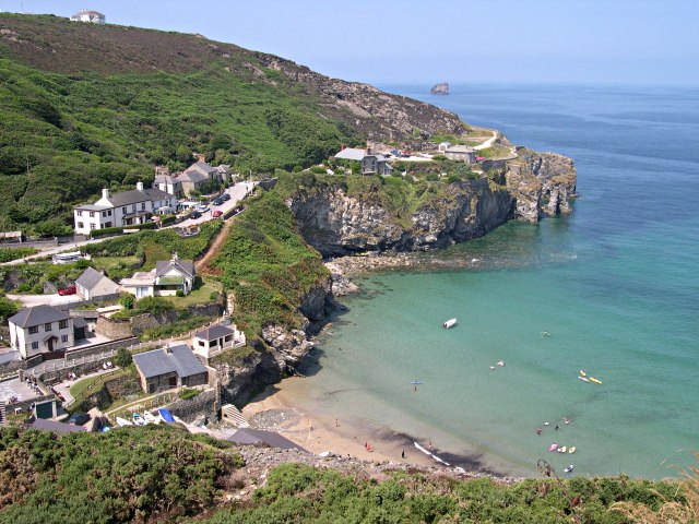
St Agnes ( kw, Breanek) is a civil parish and a large village on the north coast of Cornwall, UK. The village is about five miles (8 km) north of Redruth and ten miles (16 km) southwest of Newquay. ''and'' An electoral ward exists stretching as far south as Blackwater. The population at the 2011 census was 7,565. The village of St Agnes, a popular coastal tourist spot, lies on a main road between Redruth and Perranporth. It was a prehistoric and modern centre for mining of copper, tin and arsenic until the 1920s. Local industry has also included farming, fishing and quarrying, and more recently tourism. The St Agnes district has a heritage of industrial archaeology and much of the landscape is of considerable geological interest. There are also stone-age remains in the parish. The manor of Tywarnhaile was one of the 17 Antiqua maneria of the Duchy of Cornwall. Geography St Agnes, on Cornwall's north coast along the Atlantic Ocean, is in the Pydar hundred ... [...More Info...] [...Related Items...] OR: [Wikipedia] [Google] [Baidu] |
Redruth
Redruth ( , kw, Resrudh) is a town and civil parishes in Cornwall, civil parish in Cornwall, England. The population of Redruth was 14,018 at the 2011 census. In the same year the population of the Camborne-Redruth urban area, which also includes Carn Brea, Redruth, Carn Brea, Illogan and several satellite villages, stood at 55,400 making it the largest conurbation in Cornwall. Redruth lies approximately at the junction of the Great Britain road numbering scheme, A393 and A3047 roads, on the route of the old London to Land's End trunk road (now the A30 road, A30), and is approximately west of Truro, east of St Ives, Cornwall, St Ives, north east of Penzance, Cornwall, Penzance and north west of Falmouth, Cornwall, Falmouth. Camborne and Redruth together form the largest urban area in Cornwall and before local government reorganisation were an Urban district (Great Britain and Ireland), urban district. Toponymy The name Redruth derives from its older Cornish name, ''Rhy ... [...More Info...] [...Related Items...] OR: [Wikipedia] [Google] [Baidu] |
Wheal Concord
Blackwater () is a village in Cornwall, England, United Kingdom. It is situated in the parish of St Agnes between Truro and Redruth. The village lies on the old course of the A30 north of the current course which bypasses it. The village has a primary school (built in 1877) which serves the village and surrounding settlements. History Over the course of Blackwater's history, the town has supported four public houses: Clinton House, Cornish Miners Inn, The Red Lion and The Spread Eagle. The Chacewater to Newquay railway line (1903–1963) crossed through Blackwater. A station building was located south of Presingoll Barns near St Agnes. In 1972 the railway bridge was destroyed. Geology In an 1824 published geological study, 19th century Blackwell was described as follows: "Descending into a little valley at Blackwater, slate and compact rock present themselves in a section afforded by a ravine. In this valley cultivated fields and a few trees gladden the eye; but this oasis i ... [...More Info...] [...Related Items...] OR: [Wikipedia] [Google] [Baidu] |


