|
Starehe
Starehe is a neighbourhood in the city of Nairobi. It is approximately east of the central business district of Nairobi. It is one of the oldest estates in Nairobi. Location Starehe is located approximately east of Nairobi's central business district. It is straddled by General Waruingi Road to the south and borders other neighbourhoods such as Kariokor, Pumwani and Ziwani. Overview Starehe is one of Nairobi's oldest neighbourhoods, dating back to the 1920s. Built between 1942 and 1946, based on the design by Kenya Government architect Peter Dangerfield, Starehe provided for single-family houses and dormitories suitable for bachelors. Starehe was the second of the three estates in Nairobi to employ the garden city concept after Ziwani then Kaloleni. Land on the westerly parts of Starehe estate that was originally had housing units, is currently occupied by a secondary school: Starehe Boys' Centre and School. The piece of land set aside for establishment of a boys and gi ... [...More Info...] [...Related Items...] OR: [Wikipedia] [Google] [Baidu] |
Starehe Boys' Centre And School
Starehe Boys' Centre and School (popularly known as "Starehe") is a partial-board, boys-only school in Nairobi, Kenya. The school was founded in 1959 by Dr. Geoffrey William Griffin, MBS, OBE, Geoffrey Gatama Geturo and Joseph Kamiru Gikubu. It started as a rescue centre in Nairobi. Starehe and Brookhouse School are the only African schools south of the Sahara and north of the Limpopo distinguished as Round Square members. Status Starehe Boys' Centre and School educates at least 70% of its students free, and the rest at a reduced rate. This stems from its founding charter as a charitable school. School fees are paid on a means-tested basis, with substantial subsidies paid by the school, so that students from all walks of life are able to have a public school education that would otherwise be beyond their means. The entrance process uses results from the national KCPE exams and prefers to award school places to those who show academic potential. The school is governed by a ... [...More Info...] [...Related Items...] OR: [Wikipedia] [Google] [Baidu] |
Starehe Constituency
Starehe Constituency is an electoral constituency in Kenya. It is one of seventeen constituencies in Nairobi City County. It consists of central and central to north areas of Nairobi. The constituency was established for the 1966 elections, with an area of . It borders Westlands Constituency to the north; Mathare Constituency to the northeast; Kamukunji and Makadara constituencies to the east; Embakasi South Constituency to the south; Dagoretti North, Kibra and Lang'ata Lang'ata is a predominantly middle-class residential suburb of Nairobi in Kenya. The suburb consists of many smaller housing developments, referred to as estates. They include Nairobi Dam, Otiende, Southlands, Ngei, Jambo estate, Onyonka, Mada ... constituencies to the west. Members of Parliament Electoral wards Following the 2013 election, Starehe six electoral wards are Nairobi Central, Ngara, Pangani, Landimawe, South B and Ziwani/ Kariokor. Starehe Sub-county The Sub-county partly shares the s ... [...More Info...] [...Related Items...] OR: [Wikipedia] [Google] [Baidu] |
Nairobi City County
Nairobi City County is one of the 47 counties of Kenya. With a population of 4,397,073 in the 2019 census, it is the third smallest yet the most populous of the counties, also serving as the capital city, capital of Kenya. In 2013, the county entity was effected, replacing Nairobi City Council, the long-standing unit of administration since pre-independence. The city county consists of eleven gazetted Sub-Counties of Kenya, sub-counties and eighty five electoral wards. On the national level, Nairobi also sends seventeen Members of Parliament across the constituencies and one County woman representative, County Woman Representative to the National Assembly (Kenya), National Assembly; one senator to the Senate of Kenya, Senate. The county government, which is allocated devolved functions as per the constitution of Kenya, constitution, is headed by the County Governors of Kenya, county governor, who appoints his cabinet. The county's legislature is headed by the County Speaker, who ... [...More Info...] [...Related Items...] OR: [Wikipedia] [Google] [Baidu] |
Nairobi
Nairobi ( ) is the capital and largest city of Kenya. The name is derived from the Maasai phrase ''Enkare Nairobi'', which translates to "place of cool waters", a reference to the Nairobi River which flows through the city. The city proper had a population of 4,397,073 in the 2019 census, while the metropolitan area has a projected population in 2022 of 10.8 million. The city is commonly referred to as the Green City in the Sun. Nairobi was founded in 1899 by colonial authorities in British East Africa, as a rail depot on the Uganda - Kenya Railway.Roger S. Greenway, Timothy M. Monsma, ''Cities: missions' new frontier'', (Baker Book House: 1989), p.163. The town quickly grew to replace Mombasa as the capital of Kenya in 1907. After independence in 1963, Nairobi became the capital of the Republic of Kenya. During Kenya's colonial period, the city became a centre for the colony's coffee, tea and sisal industry. The city lies in the south central part of Kenya, at an elevation ... [...More Info...] [...Related Items...] OR: [Wikipedia] [Google] [Baidu] |
Ziwani, Nairobi
Ziwani is a neighbourhood in the city of Nairobi. It is approximately east of the central business district of Nairobi. It is one of the oldest estates in Nairobi. Location Ziwani is located approximately east of Nairobi's central business district. It is lies between General Waruingi Road, Quarry Road and borders, Starehe estate to the east. Overview The original blueprint of the Ziwani estates dates back to 1939. Actualisation began later in 1940 making the estate as one of Nairobi's oldest neighbourhoods. Built in order to remedy the housing shortage in the city among government-employed Africans, Ziwani, Kaloleni and Starehe were to contain two-three thousands dwellings and two-three thousand residents each. Ziwani was the first native estate and was designed by municipal engineer G. Fletcher. Ziwani provided for a range of housing that corresponded to the varying income levels as well as family structures, though single-family houses were not included. The houses were ... [...More Info...] [...Related Items...] OR: [Wikipedia] [Google] [Baidu] |
Counties Of Kenya
The Counties of Kenya ( sw, Kaunti za Kenya) are geographical units envisioned by the 2010 Constitution of Kenya as the new units of devolved government that replaced the previous provincial system. The establishment and executive powers of the counties is provided in Chapter Eleven of the Constitution on devolved government, the Constitution's Fourth Schedule and any other legislation passed by the Senate of Kenya concerning counties. The counties are also single-member constituencies for the election of members of parliament to the Senate of Kenya, and special women members to the National Assembly of Kenya. As of 2022, there are 47 counties whose size and boundaries are based on the 47 legally recognized regions established by the 2010 Constitution. Following the re-organization of Kenya's national administration, counties were integrated into a new national administration with the national government posting county commissioners to counties to serve as a collaborative ... [...More Info...] [...Related Items...] OR: [Wikipedia] [Google] [Baidu] |
Sub-Counties Of Kenya
Sub-counties are the decentralised units through which county governments of Kenya will provide functions and services. Except for the parts which fall under urban areas, sub-counties will coincide with the constituencies created under article 89 of the Constitution of Kenya. Sub-counties will be headed by a sub-county administrator, appointed by a County Public Service Board. Under the former Constitution of Kenya, the Provinces of Kenya were subdivided into a number of districts (''wilaya''). In line with restructuring the national administration to fit with the devolved government system brought in by the 2010 Constitution, that came into full effect following elections in March 2013, the 8 provinces and their administrators and districts were replaced by County Commissioners at the county level, while former districts existing as of 2013 were re-organised as sub-counties, and had Deputy Commissioners appointed over them. List of the 46 districts plus the capital of Kenya ... [...More Info...] [...Related Items...] OR: [Wikipedia] [Google] [Baidu] |
Central Business District
A central business district (CBD) is the commercial and business centre of a city. It contains commercial space and offices, and in larger cities will often be described as a financial district. Geographically, it often coincides with the "city centre" or "downtown". However, these concepts are not necessarily synonymous: many cities have a central ''business'' district located away from its commercial and or cultural centre and or downtown/city centre, and there may be multiple CBDs within a single urban area. The CBD will often be characterised by a high degree of accessibility as well as a large variety and concentration of specialised goods and services compared to other parts of the city. For instance, Midtown Manhattan, New York City, is the largest central business district in the city and in the United States. London's city centre is usually regarded as encompassing the historic City of London and the medieval City of Westminster, while the City of London and the transform ... [...More Info...] [...Related Items...] OR: [Wikipedia] [Google] [Baidu] |
Pumwani
Pumwani is an estate of Nairobi. In 2005 it had an estimated population of 29,616. The Pumwani Maternity Hospital is located in Pumwani. It is the largest public maternity hospital in Kenya. Many Kenyan freedom fighters are known to have lived in Pumwani including the first and the second presidents, Jomo Kenyatta and Daniel Moi. It is also the place where Lord Burden Powell founded the first scouts movement in the interior of Africa. The St. John's Church is also located in Pumwani. It is the seat of St. John's Archdeaconry of Anglican Church of Kenya. Pumwani division Prior to 2013, Pumwani was also a name of a larger administrative area, Pumwani division. The division was subdivided into five locations: Bahati, Eastleigh North, Eastleigh South, Kamukunji and Pumwani.UN Office for the Coordination of Humanitarian Affairs (OCHA)Kenya_AdminLevels_1-4/ref> Pumwani division had identical borders with Kamukunji Constituency Kamukunji Constituency is an el ... [...More Info...] [...Related Items...] OR: [Wikipedia] [Google] [Baidu] |
Single-family House
A stand-alone house (also called a single-detached dwelling, detached residence or detached house) is a free-standing residential building. It is sometimes referred to as a single-family home, as opposed to a multi-family residential dwelling. Definitions The definition of this type of house may vary between legal jurisdictions or statistical agencies. The definition, however, generally includes two elements: * Single-family (home, house, or dwelling) means that the building is usually occupied by just one household or family, and consists of just one dwelling unit or suite. In some jurisdictions allowances are made for basement suites or mother-in-law suites without changing the description from "single family". It does exclude, however, any short-term accommodation (hotel, motels, inns), large-scale rental accommodation ( rooming or boarding houses, apartments), or condominia. * Detached (house, home, or dwelling) means that the building does not share wall with oth ... [...More Info...] [...Related Items...] OR: [Wikipedia] [Google] [Baidu] |
Garden City Movement
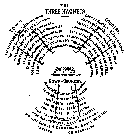
The garden city movement was a 20th century urban planning movement promoting satellite communities surrounding the central city and separated with greenbelts. These Garden Cities would contain proportionate areas of residences, industry, and agriculture. Ebenezer Howard first posited the idea in 1898 as a way to capture the primary benefits of the countryside and the city while avoiding the disadvantages presented by both. In the early 20th century, Letchworth, Brentham Garden Suburb and Welwyn Garden City were built in or near London according to Howard's concept and many other garden cities inspired by his model have since been built all over the world. History Conception Inspired by the utopian novel ''Looking Backward'' and Henry George's work ''Progress and Poverty'', Howard published the book '': a Peaceful Path to Real Reform'' in 1898 (which was reissued in 1902 as ''Garden Cities of To-morrow''). His idealised garden city would house 32,000 people on a site of , pl ... [...More Info...] [...Related Items...] OR: [Wikipedia] [Google] [Baidu] |


.jpg)

