|
St. Andrews North Point Lighthouse
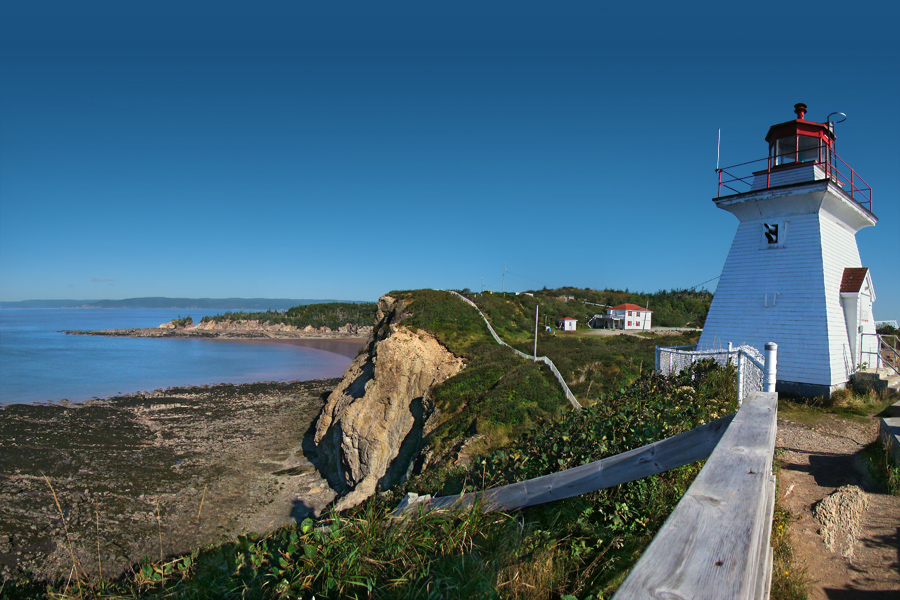
The St. Andrews North Point Lighthouse is an active lighthouse in St. Andrews, New Brunswick on the southern tip of the peninsula in the Passamaquoddy Bay; it is commonly known as ''Pendlebury Lighthouse'' from the name of the family who took care of it. History The first lighthouse was built in 1833 and consisted of a white wooden octagonal pyramidal tower with balcony and red lantern. In 1840 the foundation were secured and the lantern was changed because it was deemed to be unfit. In 1842 John Pendlebury was transferred from Machias Seal Island to become the second keeper of the lighthouse, beginning a family dynasty of keepers until 1938 when the light was decommissioned. The active lighthouse is offshore, white quadrangular metal skeletal tower high on concrete base. The light is positioned at above sea level and emits one red flash in a 4 seconds period visible up to a distance of . The old lighthouse is managed by St. Andrews Civic Trust Inc. Keepers * James Smit ... [...More Info...] [...Related Items...] OR: [Wikipedia] [Google] [Baidu] |
Lighthouse
A lighthouse is a tower, building, or other type of physical structure designed to emit light from a system of lamps and lenses and to serve as a beacon for navigational aid, for maritime pilots at sea or on inland waterways. Lighthouses mark dangerous coastlines, hazardous shoals, reefs, rocks, and safe entries to harbors; they also assist in aerial navigation. Once widely used, the number of operational lighthouses has declined due to the expense of maintenance and has become uneconomical since the advent of much cheaper, more sophisticated and effective electronic navigational systems. History Ancient lighthouses Before the development of clearly defined ports, mariners were guided by fires built on hilltops. Since elevating the fire would improve the visibility, placing the fire on a platform became a practice that led to the development of the lighthouse. In antiquity, the lighthouse functioned more as an entrance marker to ports than as a warning signal for reefs a ... [...More Info...] [...Related Items...] OR: [Wikipedia] [Google] [Baidu] |
Passamaquoddy Bay
Passamaquoddy Bay (french: Baie de Passamaquoddy) is an inlet of the Bay of Fundy, between the U.S. state of Maine and the Canadian province of New Brunswick, at the mouth of the St. Croix River. Most of the bay lies within Canada, with its western shore bounded by Washington County, Maine. The southernmost point is formed by West Quoddy Head on the U.S. mainland in Lubec, Maine; and runs northeasterly through Campobello Island, New Brunswick, engulfing Deer Island, New Brunswick, to the New Brunswick mainland head at L'Etete, New Brunswick in Charlotte County, New Brunswick. Overview The exact demarcation of the border in Passamaquoddy Bay was a long-standing issue between the United States and Britain/Canada. Already the Treaty of Ghent, ending the War of 1812, included a provision for the appointment of "commissioners to divide the islands of Passamaquoddy Bay between the United States and Great Britain" (see John Holmes). Nevertheless, confusions and ambiguities on t ... [...More Info...] [...Related Items...] OR: [Wikipedia] [Google] [Baidu] |
Machias Seal Island
Machias Seal Island is an island in disputed water between the Gulf of Maine and the Bay of Fundy, about southeast from Cutler, Maine, and southwest of Grand Manan Island, New Brunswick. Sovereignty of the island is disputed by the United States and Canada. The Canadian Coast Guard continues to staff a lighthouse on the island; the first lighthouse was constructed there in 1832. Geography The relationship of Machias Seal Island to the Grand Manan archipelago is a source of some dispute among geologists. The island is considered to be a possible continuation of the series of exposed shoals, rocks, and islets strewn south and west of Grand Manan Island. The deeper Grand Manan Channel lies to the north and west of the island, separating it from the coast of Washington County, Maine. Machias Seal Island is a barren island and devoid of trees. Because of its location at the boundary between the Gulf of Maine and the Bay of Fundy, Machias Seal Island is fog-bound for many days of t ... [...More Info...] [...Related Items...] OR: [Wikipedia] [Google] [Baidu] |
Lighthouse At St Andrews Circa 1895
A lighthouse is a tower, building, or other type of physical structure designed to emit light from a system of lamps and lenses and to serve as a beacon for navigational aid, for maritime pilots at sea or on inland waterways. Lighthouses mark dangerous coastlines, hazardous shoals, reefs, rocks, and safe entries to harbors; they also assist in aerial navigation. Once widely used, the number of operational lighthouses has declined due to the expense of maintenance and has become uneconomical since the advent of much cheaper, more sophisticated and effective electronic navigational systems. History Ancient lighthouses Before the development of clearly defined ports, mariners were guided by fires built on hilltops. Since elevating the fire would improve the visibility, placing the fire on a platform became a practice that led to the development of the lighthouse. In antiquity, the lighthouse functioned more as an entrance marker to ports than as a warning signal for ree ... [...More Info...] [...Related Items...] OR: [Wikipedia] [Google] [Baidu] |
Above Sea Level
Height above mean sea level is a measure of the vertical distance (height, elevation or altitude) of a location in reference to a historic mean sea level taken as a vertical datum. In geodesy, it is formalized as ''orthometric heights''. The combination of unit of measurement and the physical quantity (height) is called "metres above mean sea level" in the metric system, while in United States customary and imperial units it would be called "feet above mean sea level". Mean sea levels are affected by climate change and other factors and change over time. For this and other reasons, recorded measurements of elevation above sea level at a reference time in history might differ from the actual elevation of a given location over sea level at a given moment. Uses Metres above sea level is the standard measurement of the elevation or altitude of: * Geographic locations such as towns, mountains and other landmarks. * The top of buildings and other structures. * Flying objects such ... [...More Info...] [...Related Items...] OR: [Wikipedia] [Google] [Baidu] |
Light Characteristic
A light characteristic is all of the properties that make a particular navigational light identifiable. Graphical and textual descriptions of navigational light sequences and colours are displayed on nautical charts and in Light Lists with the chart symbol for a lighthouse, lightvessel, buoy or sea mark with a light on it. Different lights use different colours, frequencies and light patterns, so mariners can identify which light they are seeing. Abbreviations While light characteristics can be described in prose, e.g. "Flashing white every three seconds", lists of lights and navigation chart annotations use abbreviations. The abbreviation notation is slightly different from one light list to another, with dots added or removed, but it usually follows a pattern similar to the following (see the chart to the right for examples). * An abbreviation of the type of light, e.g. "Fl." for flashing, "F." for fixed. * The color of the light, e.g. "W" for white, "G" for green, "R" for red, ... [...More Info...] [...Related Items...] OR: [Wikipedia] [Google] [Baidu] |
Pendlebury Lighthouse - 52016336020
Pendlebury is a town in the City of Salford, Greater Manchester, England. The population at the 2011 Census was 13,069. It lies north-west of Manchester city centre, north-west of Salford and south-east of Bolton. Historically in Lancashire, Pendlebury, together with the neighbouring settlements of Swinton and Clifton, formed the municipal borough of Swinton and Pendlebury. Pendlebury saw extensive coal extraction from several collieries until the closure of Agecroft Colliery in the 1990s. History Early history Pendlebury is formed from the Celtic ''pen'' meaning hill and ''burh'' a settlement. The township was variously recorded as Penelbiri, Pennilbure, Pennebire and Pennesbyry in the 13th century, Penilburi in 1300, Penulbury in 1332; Penhulbury in 1358, Pendulbury in 1561 and Pendlebury after 1567. In 1199 King John confirmed a gift of a carucate of land called Peneberi to Ellis son of Robert. He had made the grant when he was Earl of Mortain (1189–99) and ... [...More Info...] [...Related Items...] OR: [Wikipedia] [Google] [Baidu] |
List Of Lighthouses In New Brunswick ...
This is a list of lighthouses in New Brunswick. Lighthouses See also *List of lighthouses in Canada References External links New Brunswick Lighthouses''Lighthouses Friends''. Retrieved 18 February 2017 List of Lights, Buoys and Fog Signals''Canadian Coast Guard''. Retrieved 18 February 2017 {{Lighthouses of Canada Newfoundland and Labrador Lighthouses A lighthouse is a tower, building, or other type of physical structure designed to emit light from a system of lamps and lenses and to serve as a beacon for navigational aid, for maritime pilots at sea or on inland waterways. Lighthouses mark ... [...More Info...] [...Related Items...] OR: [Wikipedia] [Google] [Baidu] |
List Of Lighthouses In Canada
This is a list of lighthouses in Canada. These may naturally be divided into lighthouses on the Pacific coast, on the Arctic Ocean, in the Hudson Bay watershed, on the Labrador Sea and Gulf of St. Lawrence, in the St. Lawrence River watershed (including the Great Lakes), and on the Atlantic seaboard. British Columbia *Active Pass Lighthouse *Addenbroke Island Lightstation *Amphitrite Point Lighthouse *Boat Bluff lighthouse *Bonilla Island Lightstation *Brockton Point Lightstation *Cape Beale Lightstation *Cape Mudge Lighthouse *Cape Scott Lighthouse *Carmanah Point Light Station *Chatham Point lighthouse *Chrome Island Lightstation *Discovery Island Light *Dryad Point Lighthouse *Egg Island Lightstation *Entrance Island (British Columbia), Entrance Island Lightstation *Estevan Point Lighthouse *Fisgard Lighthouse, the oldest lighthouse on the West Coast of Canada. *Gallows Point Light *Green Island Lightstation *Holland Rock Lightstation *Ivory Island Lightstation *Kains Islan ... [...More Info...] [...Related Items...] OR: [Wikipedia] [Google] [Baidu] |
Lighthouses In New Brunswick
A lighthouse is a tower, building, or other type of physical structure designed to emit light from a system of lamps and lenses and to serve as a beacon for navigational aid, for maritime pilots at sea or on inland waterways. Lighthouses mark dangerous coastlines, hazardous shoals, reefs, rocks, and safe entries to harbors; they also assist in aerial navigation. Once widely used, the number of operational lighthouses has declined due to the expense of maintenance and has become uneconomical since the advent of much cheaper, more sophisticated and effective electronic navigational systems. History Ancient lighthouses Before the development of clearly defined ports, mariners were guided by fires built on hilltops. Since elevating the fire would improve the visibility, placing the fire on a platform became a practice that led to the development of the lighthouse. In antiquity, the lighthouse functioned more as an entrance marker to ports than as a warning signal for reefs and ... [...More Info...] [...Related Items...] OR: [Wikipedia] [Google] [Baidu] |
Lighthouses Completed In 1833
A lighthouse is a tower, building, or other type of physical structure designed to emit light from a system of lamps and lenses and to serve as a beacon for navigational aid, for maritime pilots at sea or on inland waterways. Lighthouses mark dangerous coastlines, hazardous shoals, reefs, rocks, and safe entries to harbors; they also assist in aerial navigation. Once widely used, the number of operational lighthouses has declined due to the expense of maintenance and has become uneconomical since the advent of much cheaper, more sophisticated and effective electronic navigational systems. History Ancient lighthouses Before the development of clearly defined ports, mariners were guided by fires built on hilltops. Since elevating the fire would improve the visibility, placing the fire on a platform became a practice that led to the development of the lighthouse. In antiquity, the lighthouse functioned more as an entrance marker to ports than as a warning signal for reefs and ... [...More Info...] [...Related Items...] OR: [Wikipedia] [Google] [Baidu] |
Saint Andrews, New Brunswick
Saint Andrews (2016 population: 1,786) is a town in Charlotte County, New Brunswick, Canada. The historic town is a national historic site of Canada, bearing many characteristics of a typical 18th century British colonial settlement, including the original grid layout with its market square, and the classical architecture. Although often shortened in non-official sources to St. Andrews, the town's legal name is spelt Saint Andrews, and appears as such on the town's website; St. Andrews by-the-Sea is a brand used for tourism purposes by the local Chamber of Commerce. History The site of the town was named Qunnnoskwamk'ook, meaning long gravel bar in the Malecite-Passamaquoddy language. The present name was given by a French missionary who landed at the site on Saint Andrew's Day. At the eastern end the town is a midden, a pile of shells and other refuse that accumulated over two thousand years due to year-round activity of the Passamaquoddy The Passamaquoddy ( Maliseet-P ... [...More Info...] [...Related Items...] OR: [Wikipedia] [Google] [Baidu] |


