|
Shaikpet
Shaikpet is located near Tolichowki in Hyderabad, India. It is a mandal in Hyderabad District and one of the oldest suburbs of Hyderabad. It has existed for a long while now. This was a legislative assembly seat in its name, now after delimation this area comes in Jubilee Hills seat. It is administered as Ward No. 94 of Greater Hyderabad Municipal Corporation The Greater Hyderabad Municipal Corporation, commonly known as the GHMC is the civic body that oversees Hyderabad, the capital and largest city of the Indian state of Telangana. It is the local government for the cities of Hyderabad and Secund .... Revenue Villages of Shaikpet Mandals and villages of Hyderabad District include: *Shaikpet *Hakeempet *Bakhtawarguda References Mandals in Telangana Municipal wards of Hyderabad, India {{Telangana-geo-stub ... [...More Info...] [...Related Items...] OR: [Wikipedia] [Google] [Baidu] |
Hyderabad District, India
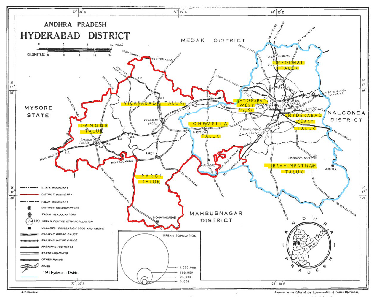
Hyderabad district is a most populous district in the state of Telangana in India that contains a part of the metropolitan area of Hyderabad. It is headed by a district collector who is drawn from the IAS cadre and is appointed by the state government. It is the smallest of all the districts in the state, but has the highest human density. Old MCH area, which is central region of Hyderabad city comes under this district.The district share boundaries with Rangareddy and Medhchal districts. History Hyderabad district was formed in 1948 after Operation Polo by merging Atraf-a-Balda District and Baghat District. Baghat was previously a Taluk in Atraf-e-Balda District, and was made a separate district in 1931–34 under the subedar of Medak division. After formation of Andhra Pradesh by merging Telugu speaking of Hyderabad state in 1956 Hyderabad district boundary was altered Tandur Taluka which is Telugu speaking region of Gulbarga district was merged in Hyderabad district and ... [...More Info...] [...Related Items...] OR: [Wikipedia] [Google] [Baidu] |
Hyderabad Corporation Zones, Circles And Wards
Hyderabad Corporation zones, circles and wards are divided by the Greater Hyderabad Municipal Corporation (GHMC) for its planning and development in Hyderabad, India India, officially the Republic of India (Hindi: ), is a country in South Asia. It is the seventh-largest country by area, the second-most populous country, and the most populous democracy in the world. Bounded by the Indian Ocean on the so .... The city of Hyderabad is divided into six zones: Charminar, L. B. Nagar, Serilingampally, Kukatpally, Secunderabad and Khairatabad. Each zone is further divided into circles, thirty in total. The circles are subdivided into 150 wards, each with around 36,000 people in 2007; which later increased to 40,000 - 50,000 people in 2020. The GHMC is planning to increase the number of wards to 200. List of wards References {{DEFAULTSORT:Hyderabad Corporation wards Wards Administrative divisions of India by city Wards ... [...More Info...] [...Related Items...] OR: [Wikipedia] [Google] [Baidu] |
Tolichowki
Toli chowki is a neighbourhood in Hyderabad, Telangana, India. The name Tolichowki comes from the Urdu word 'Toli', meaning 'troupe', and 'Chowki', meaning 'post'. It is close to the IT corridor like Gachibowli, Madhapur, Manikonda and Kondapur, hence making it a preferred residential for people working in the IT industry. The real estate sector has received a boost due to its proximity to high-end technology firms. Tolichowki has also had a boost in the restaurant and fast food industry. It is known to attract many customers from all around due to having multi-cuisine meals all around the area. There has been an emergence of Arab cuisine in the area due to Middle Eastern people's moving in the area for medical or academic purposes. This in return has improved Tolichowki's market value for foreigners History During the period of Abul Hasan Qutb Shah, the troops of Mughal Emperor Aurangzeb Alamgir set a military position in this region, which is in the vicinity of the Golc ... [...More Info...] [...Related Items...] OR: [Wikipedia] [Google] [Baidu] |
States And Territories Of India
India is a federal union comprising 28 states and 8 union territories, with a total of 36 entities. The states and union territories are further subdivided into districts and smaller administrative divisions. History Pre-independence The Indian subcontinent has been ruled by many different ethnic groups throughout its history, each instituting their own policies of administrative division in the region. The British Raj mostly retained the administrative structure of the preceding Mughal Empire. India was divided into provinces (also called Presidencies), directly governed by the British, and princely states, which were nominally controlled by a local prince or raja loyal to the British Empire, which held ''de facto'' sovereignty ( suzerainty) over the princely states. 1947–1950 Between 1947 and 1950 the territories of the princely states were politically integrated into the Indian union. Most were merged into existing provinces; others were organised into ... [...More Info...] [...Related Items...] OR: [Wikipedia] [Google] [Baidu] |
Urban Planning
Urban planning, also known as town planning, city planning, regional planning, or rural planning, is a technical and political process that is focused on the development and design of land use and the built environment, including air, water, and the infrastructure passing into and out of urban areas, such as transportation, communications, and distribution networks and their accessibility. Traditionally, urban planning followed a top-down approach in master planning the physical layout of human settlements. The primary concern was the public welfare, which included considerations of efficiency, sanitation, protection and use of the environment, as well as effects of the master plans on the social and economic activities. Over time, urban planning has adopted a focus on the social and environmental bottom-lines that focus on planning as a tool to improve the health and well-being of people while maintaining sustainability standards. Sustainable development was added as one of th ... [...More Info...] [...Related Items...] OR: [Wikipedia] [Google] [Baidu] |
Greater Hyderabad Municipal Corporation
The Greater Hyderabad Municipal Corporation, commonly known as the GHMC is the civic body that oversees Hyderabad, the capital and largest city of the Indian state of Telangana. It is the local government for the cities of Hyderabad and Secunderabad. It is one of the largest municipal corporations in India with a population of 7.9 million and an area of 650 km². History Hyderabad Municipal Board and Chaderghat Municipal Board In 1869, Municipal administration was first introduced for the city of Hyderabad. The city of Hyderabad was divided into four and the suburbs of Chaderghat were divided into five divisions. The whole management of both the city and the suburbs was handled by the then City Police Commissioner, Kotwal-e-Baldia. In the same year, Sir Salar Jung-1, the then Prime Minister of Hyderabad State under the Nizam, has constituted the Department of Municipal and Road Maintenance. He also appointed a Municipal Commissioner for Hyderabad Board and Chaderg ... [...More Info...] [...Related Items...] OR: [Wikipedia] [Google] [Baidu] |
Jubilee Hills
Jubilee Hills is an affluent suburban neighbourhood in Western part of Hyderabad, Telangana. It is one of the most expensive commercial and residential locations in India with prime land prices fetching up to 300,000 ($4015) per square yard. A tract of land in the city was sold for nearly 3,340,000,000 ($66,800,000) in 2005. Rental prices on Road Numbers 36 and 37 range from 100–200 per square foot, among the top commercial rental locales in India. This suburb is between the wealthy commercial district of Banjara Hills and is located within two kilometres of Hyderabad's IT hub of HITEC City. To its southeast is the Kasu Brahmananda Reddy National Park, the erstwhile Chiran Palace, which is one of the largest urban national parks in India covering an area of . History The idea of Jubilee Hills came about in 1963. In 1967, IAS officer and Padma Shri award winner, Challagalla Narasimham was asked to become the President and "help proper development of the colony". He was though ... [...More Info...] [...Related Items...] OR: [Wikipedia] [Google] [Baidu] |
India
India, officially the Republic of India (Hindi: ), is a country in South Asia. It is the seventh-largest country by area, the second-most populous country, and the most populous democracy in the world. Bounded by the Indian Ocean on the south, the Arabian Sea on the southwest, and the Bay of Bengal on the southeast, it shares land borders with Pakistan to the west; China, Nepal, and Bhutan to the north; and Bangladesh and Myanmar to the east. In the Indian Ocean, India is in the vicinity of Sri Lanka and the Maldives; its Andaman and Nicobar Islands share a maritime border with Thailand, Myanmar, and Indonesia. Modern humans arrived on the Indian subcontinent from Africa no later than 55,000 years ago., "Y-Chromosome and Mt-DNA data support the colonization of South Asia by modern humans originating in Africa. ... Coalescence dates for most non-European populations average to between 73–55 ka.", "Modern human beings—''Homo sapiens''—originated in Africa. Then, int ... [...More Info...] [...Related Items...] OR: [Wikipedia] [Google] [Baidu] |
Hyderabad, India
Hyderabad ( ; , ) is the capital and largest city of the Indian state of Telangana and the '' de jure'' capital of Andhra Pradesh. It occupies on the Deccan Plateau along the banks of the Musi River, in the northern part of Southern India. With an average altitude of , much of Hyderabad is situated on hilly terrain around artificial lakes, including the Hussain Sagar lake, predating the city's founding, in the north of the city centre. According to the 2011 Census of India, Hyderabad is the fourth-most populous city in India with a population of residents within the city limits, and has a population of residents in the metropolitan region, making it the sixth-most populous metropolitan area in India. With an output of 74 billion, Hyderabad has the fifth-largest urban economy in India. Muhammad Quli Qutb Shah established Hyderabad in 1591 to extend the capital beyond the fortified Golconda. In 1687, the city was annexed by the Mughals. In 1724, Asaf Jah I, th ... [...More Info...] [...Related Items...] OR: [Wikipedia] [Google] [Baidu] |
Lok Sabha
The Lok Sabha, constitutionally the House of the People, is the lower house of India's bicameral Parliament, with the upper house being the Rajya Sabha. Members of the Lok Sabha are elected by an adult universal suffrage and a first-past-the-post system to represent their respective constituencies, and they hold their seats for five years or until the body is dissolved by the President on the advice of the council of ministers. The house meets in the Lok Sabha Chambers of the Sansad Bhavan, New Delhi. The maximum membership of the House allotted by the Constitution of India is 552 (Initially, in 1950, it was 500). Currently, the house has 543 seats which are made up by the election of up to 543 elected members and at a maximum. Between 1952 and 2020, 2 additional members of the Anglo-Indian community were also nominated by the President of India on the advice of Government of India, which was abolished in January 2020 by the 104th Constitutional Amendment Act, 2019. The ... [...More Info...] [...Related Items...] OR: [Wikipedia] [Google] [Baidu] |
Secunderabad, India
Secunderabad, also spelled as Sikandarabad (, ), is a twin city of Hyderabad and one of the six zones of the Greater Hyderabad Municipal Corporation (GHMC) in the Indian state of Telangana. It is the headquarters of the South Central Railway zone. Named after the Mir Akbar Ali Khan Sikander Jah, Asaf Jah III, Nizam of the Asaf Jahi dynasty, Secunderabad was established in 1806 as a British cantonment. Although both the cities are together referred to as the twin cities, Hyderabad and Secunderabad have different histories and cultures, with Secunderabad having developed directly under British rule until 1948, and Hyderabad as the capital of the Nizams' princely state of Hyderabad. Geographically divided from Hyderabad by the Hussain Sagar lake, Secunderabad is no longer a separate municipal unit and has become part of Hyderabad's Greater Hyderabad Municipal Corporation. Both cities are collectively known as Hyderabad and together form the sixth-largest metropolis in India. Bei ... [...More Info...] [...Related Items...] OR: [Wikipedia] [Google] [Baidu] |
Telangana
Telangana (; , ) is a States and union territories of India, state in India situated on the south-central stretch of the Indian subcontinent, Indian peninsula on the high Deccan Plateau. It is the List of states and union territories of India by area, eleventh-largest state and the List of states and union territories of India by population, twelfth-most populated state in India with a geographical area of and 35,193,978 residents as per 2011 Census of India, 2011 census. On 2 June 2014, the area was separated from the northwestern part of Andhra Pradesh as the newly formed States and union territories of India, state with Hyderabad as its capital. Its other major cities include Warangal, Nizamabad, Telangana, Nizamabad, Khammam, Karimnagar and Ramagundam. Telangana is bordered by the states of Maharashtra to the north, Chhattisgarh to the northeast, Karnataka to the west, and Andhra Pradesh to the east and south. The terrain of Telangana consists mostly of the Deccan Plateau wi ... [...More Info...] [...Related Items...] OR: [Wikipedia] [Google] [Baidu] |


