|
Sayun
Seiyun (also transliterated as ''Saywun'', ''Sayoun'' or ''Say'un''; ar, سَيْئُوْن Hadhrami pronunciation: , Literary Arabic: ; Old South Arabian: 𐩪𐩺𐩱𐩬 ''S¹yʾn'') is a city in the region and Governorate of Hadhramaut in Yemen. It is located in the middle of the Hadhramaut Valley, about from Mukalla, the capital of Mukalla District and the largest city in the area, via western route. It is also away from Shibam and away from Tarim, other large cities in the valley. It is said that the origin of the city was a resting point for travellers. There was a cafe with a woman named Seiyun there, and the area was named after her in her honor. Since then, the city has become the largest area of Hadhramaut valley. The most prominent villages surrounding the city include Madurah, Mérida, Burr, Hazkir, and Houta Sultana. It is served by Seiyun Airport. It is also well known for the Seiyun Palace of the Sultan of Kathiri built in 1920s with mud and stone ... [...More Info...] [...Related Items...] OR: [Wikipedia] [Google] [Baidu] |
Sayun District
Sayun District is a district of the Hadhramaut Governorate, Yemen. As of 2003, the district had a population of 102,409 inhabitants. Geography Sayun District is about 804 square kilometers wide. The district is located in the central part of Hadhramaut and Wadi Hadhramaut. It is bordered to the south by Tarim and Sah Districts, and to the west by Shibam District. Siyoun District is about 320 kilometers from the provincial capital Mukalla Mukalla ( ar, ٱلْمُكَلَّا, ') is a seaport and the capital city of Yemen's largest governorate, Hadhramaut. The city is in the southern part of the Arabian Peninsula on the Gulf of Aden, on the shores of the Arabian Sea, about east of .... As for the terrain, the district consists of a relatively flat surface that forms a part of Wadi Hadhramaut surrounded by mountain ranges from the northern and southern sides leading to the northern and southern plateaus. These mountain ranges also penetrate several sub-valleys of Hadhramaut Vall ... [...More Info...] [...Related Items...] OR: [Wikipedia] [Google] [Baidu] |
Seiyun District
Sayun District is a district of the Hadhramaut Governorate, Yemen. As of 2003, the district had a population of 102,409 inhabitants. Geography Sayun District is about 804 square kilometers wide. The district is located in the central part of Hadhramaut and Wadi Hadhramaut. It is bordered to the south by Tarim and Sah Districts, and to the west by Shibam District. Siyoun District is about 320 kilometers from the provincial capital Mukalla Mukalla ( ar, ٱلْمُكَلَّا, ') is a seaport and the capital city of Yemen's largest governorate, Hadhramaut. The city is in the southern part of the Arabian Peninsula on the Gulf of Aden, on the shores of the Arabian Sea, about east of .... As for the terrain, the district consists of a relatively flat surface that forms a part of Wadi Hadhramaut surrounded by mountain ranges from the northern and southern sides leading to the northern and southern plateaus. These mountain ranges also penetrate several sub-valleys of Hadhramaut Vall ... [...More Info...] [...Related Items...] OR: [Wikipedia] [Google] [Baidu] |
List Of Districts Of Yemen
The governorates of Yemen are divided into 333 districts (as of 2019) ( '' mudīriyyā''). The districts are subdivided into 2,210 Uzaal (sub-districts), and then into 38,284 villages (as of 2001). The districts are listed below, by governorate: 'Aden Governorate *Al Buraiqeh District * Al Mansura District * Al Mualla District * Ash Shaikh Outhman District * Attawahi District * Craiter District * Dar Sad District *Khur Maksar District 'Amran Governorate *Al Ashah District *Al Madan District * Al Qaflah District *Amran District * As Sawd District *As Sudah District *Bani Suraim District *Dhi Bin District *Habur Zulaymah District *Harf Sufyan District *Huth District *Iyal Surayh District *Jabal Iyal Yazid District *Khamir District *Kharif District *Maswar District *Raydah District *Shaharah District * Suwayr District *Thula District Abyan Governorate *Ahwar District *Al Mahfad District *Al Wade'a District *Jayshan District *Khanfir District *Lawdar District *Mudiyah District ... [...More Info...] [...Related Items...] OR: [Wikipedia] [Google] [Baidu] |
Shibam
Shibam Hadramawt ( ar, شِبَام حَضْرَمَوْت, Shibām Ḥaḍramawt) is a town in Yemen. With about 7,000 inhabitants, it is the seat of the District of Shibam in the Governorate of Hadhramaut. Known for its mudbrick-made high-rise buildings, it is referred to as the "Chicago of the Desert" (), or "Manhattan of the Desert" (). History The first known inscription about the city dates from the 3rd century CE. It was the capital of the Hadramawt Kingdom. In the 20th century, it was one of the three major cities of the Qu'aiti Sultanate, the others being Al-Mukalla and Ash-Shihr. The city was listed with the UNESCO World Heritage List, in 1982.Bricks and mortar fire: Yemen’s cultural heritage is in the cr ... [...More Info...] [...Related Items...] OR: [Wikipedia] [Google] [Baidu] |
Hadhramaut Governorate
Hadhramaut or Hadramawt or Hadramout ( ar, حضرموت ''Ḥaḍramawt'') is a governorate of Yemen. Lying within the large historical region of Hadhramaut, it is the country's largest governorate. The capital of Hadhramut is the city of Mukalla. Other cities in Hadhramaut include the historical towns of Shibam, Sena, Seiyun, Tarim, and Ash Shihr. The Socotra Archipelago was transferred from the Adan Governorate to the Hadhramaut Governorate in 2004. It was subsequently separated to form the newly created Soqatra Governorate in December 2013. Districts Hadhramaut Governorate is divided into the following 28 districts, after the creation of Socotra Governorate on December 2013. These districts are further divided into sub-districts, and then further subdivided into villages: * Ad Dis District * Adh Dhlia'ah District * Al Abr District * Mukalla District * Mukalla City District * Al Qaf District * Al Qatn District * Amd District * Ar Raydah Wa Qusayar District * As Sawm ... [...More Info...] [...Related Items...] OR: [Wikipedia] [Google] [Baidu] |
Governorates Of Yemen
Yemen is divided into twenty-one governorates (''muhafazah'') and one municipality ( amanah): Notes: a - Also known as Sanaa City b - Socatra Governorate was created in December 2013 from parts of Hadramaut, data included there The governorates are subdivided into 333 districts (''muderiah''), which are subdivided into 1,996 sub-districts, and then into 40,793 villages and 88,817 sub villages (as of 2013). Before 1990, Yemen existed as two separate entities. South Yemen consisted of modern Aden, Abyan, Al Mahrah, Dhale, Hadramaut, Socotra, Lahij, and Shabwah Governorates, while the rest made up North Yemen. For more information, see Historic Governorates of Yemen. See also * ISO 3166-2:YE References {{DEFAULTSORT:Governorates of Yemen Subdivisions of Yemen Yemen, Governorates Yemen 1 Governorates, Yemen Yemen geography-related lists Yemen Yemen (; ar, ٱلْيَمَن, al-Yaman), officially the Republic of Yemen,, ) is a country in Western Asia. ... [...More Info...] [...Related Items...] OR: [Wikipedia] [Google] [Baidu] |
Islamic
Islam (; ar, ۘالِإسلَام, , ) is an Abrahamic monotheistic religion centred primarily around the Quran, a religious text considered by Muslims to be the direct word of God (or '' Allah'') as it was revealed to Muhammad, the main and final Islamic prophet.Peters, F. E. 2009. "Allāh." In , edited by J. L. Esposito. Oxford: Oxford University Press. . (See alsoquick reference) " e Muslims' understanding of Allāh is based...on the Qurʿān's public witness. Allāh is Unique, the Creator, Sovereign, and Judge of mankind. It is Allāh who directs the universe through his direct action on nature and who has guided human history through his prophets, Abraham, with whom he made his covenant, Moses/Moosa, Jesus/Eesa, and Muḥammad, through all of whom he founded his chosen communities, the 'Peoples of the Book.'" It is the world's second-largest religion behind Christianity, with its followers ranging between 1-1.8 billion globally, or around a quarter of the world's po ... [...More Info...] [...Related Items...] OR: [Wikipedia] [Google] [Baidu] |
Sah District
Sah District is a district of the Hadhramaut Governorate, Yemen Yemen (; ar, ٱلْيَمَن, al-Yaman), officially the Republic of Yemen,, ) is a country in Western Asia. It is situated on the southern end of the Arabian Peninsula, and borders Saudi Arabia to the Saudi Arabia–Yemen border, north and .... In 2003, the district had a population of 24,146. References Districts of Hadhramaut Governorate {{Hadhramaut-geo-stub ... [...More Info...] [...Related Items...] OR: [Wikipedia] [Google] [Baidu] |
Tarim District
Tarim District () is a district of the Hadhramaut Governorate, Yemen Yemen (; ar, ٱلْيَمَن, al-Yaman), officially the Republic of Yemen,, ) is a country in Western Asia. It is situated on the southern end of the Arabian Peninsula, and borders Saudi Arabia to the Saudi Arabia–Yemen border, north and .... As of 2003, the district had a population of 100,617 inhabitants with Tarim as its biggest city. References Districts of Hadhramaut Governorate {{Hadhramaut-geo-stub ... [...More Info...] [...Related Items...] OR: [Wikipedia] [Google] [Baidu] |
Postage Stamp
A postage stamp is a small piece of paper issued by a post office, postal administration, or other authorized vendors to customers who pay postage (the cost involved in moving, insuring, or registering mail), who then affix the stamp to the face or address-side of any item of mail—an envelope or other postal cover (e.g., packet, box, mailing cylinder)—that they wish to send. The item is then processed by the postal system, where a postmark or cancellation mark—in modern usage indicating date and point of origin of mailing—is applied to the stamp and its left and right sides to prevent its reuse. The item is then delivered to its addressee. Always featuring the name of the issuing nation (with the exception of the United Kingdom), a denomination of its value, and often an illustration of persons, events, institutions, or natural realities that symbolize the nation's traditions and values, every stamp is printed on a piece of usually rectangular, but sometimes triangular ... [...More Info...] [...Related Items...] OR: [Wikipedia] [Google] [Baidu] |
Aden Protectorate
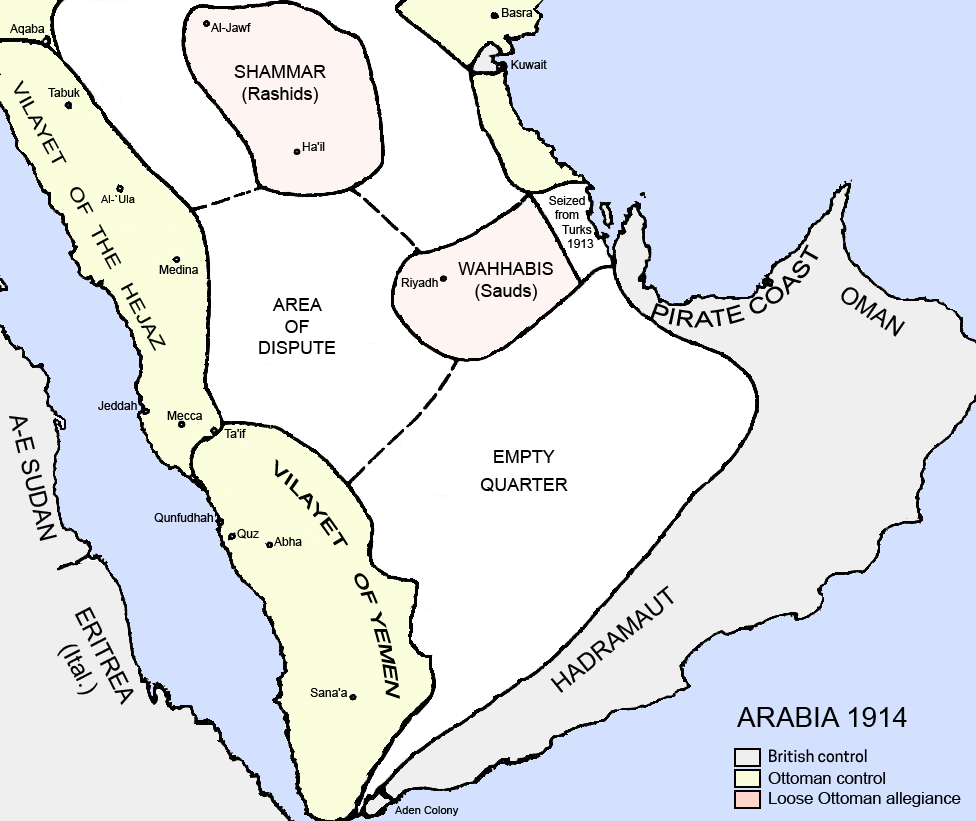
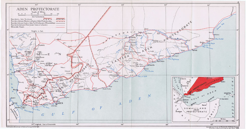
The Aden Protectorate ( ar, محمية عدن ') was a British protectorate in South Arabia which evolved in the hinterland of the port of Aden and in the Hadhramaut following the conquest of Aden by the Bombay Presidency of British India in 1839, and it continued until the 1960s. In 1940 it was divided for administrative purposes into the Western Protectorate and the Eastern Protectorate. Today the territory forms part of the Republic of Yemen. The rulers of the Aden Protectorate, as generally with the other British protectorates and protected states, remained sovereign: their flags still flew over their government buildings, government was still carried out by them or in their names, and their states maintained a distinct 'international personality' in the eyes of international law, in contrast to states forming part of the British Empire, such as Aden Colony, where the British monarch was the head of every state. History Informal beginnings What became known as the A ... [...More Info...] [...Related Items...] OR: [Wikipedia] [Google] [Baidu] |
Aden
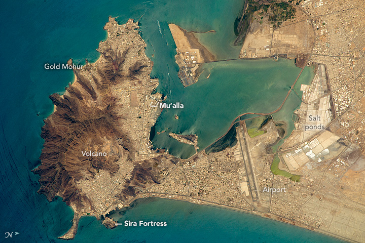
Aden ( ar, عدن ' Yemeni: ) is a city, and since 2015, the temporary capital of Yemen, near the eastern approach to the Red Sea (the Gulf of Aden), some east of the strait Bab-el-Mandeb. Its population is approximately 800,000 people. Aden's natural harbour lies in the crater of a dormant volcano, which now forms a peninsula joined to the mainland by a low isthmus. This harbour, Front Bay, was first used by the ancient Kingdom of Awsan between the 7th to 5th centuries BC. The modern harbour is on the other side of the peninsula. Aden gets its name from the Gulf of Aden. Aden consists of a number of distinct sub-centres: Crater, the original port city; Ma'alla, the modern port; Tawahi, known as "Steamer Point" in the colonial period; and the resorts of Gold Mohur. Khormaksar, on the isthmus that connects Aden proper with the mainland, includes the city's diplomatic missions, the main offices of Aden University, and Aden International Airport (the former British Roy ... [...More Info...] [...Related Items...] OR: [Wikipedia] [Google] [Baidu] |

.jpg)


