|
Satyrium Carneum
''Satyrium carneum'' is a species of orchid endemic to southwestern Western Cape. It is also known by the names pink satyr orchid, rooikappie, or rooitrewwa. Description It is a robust terrestrial that grows from 370mm to 710mm tall. Leaves are 2 to 4, thick and fleshy; the lower 2 are partly pressed onto the ground, 70mm to 230mm long, with gradual transition to the sheaths higher up. Satyrium carneum Pink Satyre 1.jpg Satyrium carneum Pink Satyre 2.jpg Distribution ''Satyrium carneum'' is found from the Cape Peninsula to Riversdale and Sedgefield. It is becoming increasingly local and rare. Habitat ''Satyrium carneum'' is found in dune bush vegetation, in fynbos on coastal hills and on ridges, on moist to dry sands and limestone, at altitudes of 10–300 m. Conservation status ''Satyrium carneum'' is classified as ''Least Concern'', as it is a common species that is declining across its range, but not yet in danger of extinction. Recent observations indicate that ... [...More Info...] [...Related Items...] OR: [Wikipedia] [Google] [Baidu] |
South African National Biodiversity Institute
The South African National Biodiversity Institute (SANBI) is an organisation established in 2004 in terms of the National Environmental Management: Biodiversity Act, No 10 of 2004, under the South African Department of Environmental Affairs (later named Department of Environment, Forestry and Fisheries), tasked with research and dissemination of information on biodiversity, and legally mandated to contribute to the management of the country’s biodiversity resources. History SANBI was established on 1 September 2004 in terms of the National Environmental Management: Biodiversity Act, No 10 of 2004. Previously, in 1989, the autonomous statutory National Botanical Institute (NBI) had been formed from the National Botanic Gardens and the Botanical Research Institute, which had been founded in the early 20th century to study and conserve the South African flora. The mandate of the National Botanical Institute was expanded by the act to include the full diversity of the South Af ... [...More Info...] [...Related Items...] OR: [Wikipedia] [Google] [Baidu] |
Fynbos
Fynbos (; meaning fine plants) is a small belt of natural shrubland or heathland vegetation located in the Western Cape and Eastern Cape provinces of South Africa. This area is predominantly coastal and mountainous, with a Mediterranean climate and rainy winters. The fynbos ecoregion is within the Mediterranean forests, woodlands, and scrub biome. In fields related to biogeography, fynbos is known for its exceptional degree of biodiversity and endemism, consisting of about 80% (8,500 fynbos) species of the Cape floral kingdom, where nearly 6,000 of them are endemic. This land continues to face severe human-caused threats, but due to the many economic uses of the fynbos, conservation efforts are being made to help restore it. Overview and history The word fynbos is often confusingly said to mean "fine bush" in Afrikaans, as "bos" means "bush". Typical fynbos foliage is ericoid rather than fine. The term, in its pre-Afrikaans, Dutch form, ''fynbosch'', was recorded by Nob ... [...More Info...] [...Related Items...] OR: [Wikipedia] [Google] [Baidu] |
Invasive Plants
An invasive species otherwise known as an alien is an introduced organism that becomes overpopulated and harms its new environment. Although most introduced species are neutral or beneficial with respect to other species, invasive species adversely affect habitats and bioregions, causing ecological, environmental, and/or economic damage. The term can also be used for native species that become harmful to their native environment after human alterations to its food webfor example the purple sea urchin (''Strongylocentrotus purpuratus'') which has decimated kelp forests along the northern California coast due to overharvesting of its natural predator, the California sea otter (''Enhydra lutris''). Since the 20th century, invasive species have become a serious economic, social, and environmental threat. Invasion of long-established ecosystems by organisms is a natural phenomenon, but human-facilitated introductions have greatly increased the rate, scale, and geographic range of ... [...More Info...] [...Related Items...] OR: [Wikipedia] [Google] [Baidu] |
Gansbaai
Gansbaai (Dutch/Afrikaans for "bay of geese," sometimes referred to as Gans Bay or Gangs Bay) is a fishing town and popular tourist destination in the Overberg District Municipality, Western Cape, South Africa. It is known for its dense population of great white sharks and as a whale-watching location. The main tourist attraction in Gansbaai since approximately 1995 has been cage diving with great white sharks. It is said that after Kruger National Park, the great white sharks attract some of the highest numbers of tourists to South Africa for any single activity. History Klipgat Cave is located in the Walker Bay Nature Reserve, next to De Kelders, the residential shore area of Gansbaai. As one of only three places in South Africa where such old remains have been excavated, Klipgat Cave is one of the most important historical sites in the Western Cape. The reserve and the cave are open to anyone that has a wild card. The earliest evidence of the presence of sheep-herding Khoi p ... [...More Info...] [...Related Items...] OR: [Wikipedia] [Google] [Baidu] |
Betty's Bay
Betty's Bay is a small holiday town situated on the Overberg coast of South Africa's Western Cape province. It is located 100 km from Cape Town beneath the Kogelberg Mountains on the scenic R44 ocean drive between Pringle Bay and Kleinmond. This village stretches over 13 km along the coast. Tourism plays a large role in the town's economy due to its popularity with holiday makers from across the Western Cape and Cape Town in particular. During colonial times Betty's Bay was allegedly a favourite place for runaway slaves, and in 1912 Betty's Bay became a formal whaling station running up until the 1930s. Remains of the whaling station can still be seen at Stony Point. Bettys Bay is named after Betty Youlden, daughter of the first developer of the area Arthur Youlden. Betty's Bay contains the Harold Porter National Botanical Garden as well as an African penguin colony in the Betty's Bay Marine Protected Area, which is one of the two Penguin colonies in the area of the Western Cape ... [...More Info...] [...Related Items...] OR: [Wikipedia] [Google] [Baidu] |
Cape Flats
The Cape Flats ( af, Die Kaapse Vlakte) is an expansive, low-lying, flat area situated to the southeast of the central business district of Cape Town. The Cape Flats is also the name of an administrative region of the City of Cape Town, which lies within the larger geographical area. Geology and geography In geological terms, the area is essentially a vast sheet of aeolian sand, ultimately of marine origin, which has blown up from the adjacent beaches over a period on the order of a hundred thousand years. Below the sand, the bedrock is in general the Malmesbury Shale, except on part of the western margin between Zeekoevlei to the south and Claremont and Wetton to the north, where an intrusive mass of Cape Granite is to be found. Most of the sand is unconsolidated; however, in some places near the False Bay coast the oldest sand dunes have been cemented into a soft sandstone (calcrete), and form low cliffs at the edge of the beach. These formations contain important fossils ... [...More Info...] [...Related Items...] OR: [Wikipedia] [Google] [Baidu] |
Urban Sprawl
Urban sprawl (also known as suburban sprawl or urban encroachment) is defined as "the spreading of urban developments (such as houses and shopping centers) on undeveloped land near a city." Urban sprawl has been described as the unrestricted growth in many urban areas of housing, commercial development, and roads over large expanses of land, with little concern for urban planning. In addition to describing a special form of urbanization, the term also relates to the social and environmental consequences associated with this development. Medieval suburbs suffered from loss of protection of city walls, before the advent of industrial warfare. Modern disadvantages and costs include increased travel time, transport costs, pollution, and destruction of the countryside. The cost of building urban infrastructure for new developments is hardly ever recouped through property taxes, amounting to a subsidy for the developers and new residents at the expense of existing property taxpayers. In ... [...More Info...] [...Related Items...] OR: [Wikipedia] [Google] [Baidu] |
Habitat Destruction
Habitat destruction (also termed habitat loss and habitat reduction) is the process by which a natural habitat becomes incapable of supporting its native species. The organisms that previously inhabited the site are displaced or dead, thereby reducing biodiversity and species abundance. Habitat destruction is the leading cause of biodiversity loss. Fragmentation and loss of habitat have become one of the most important topics of research in ecology as they are major threats to the survival of endangered species. Activities such as harvesting natural resources, industrial production and urbanization are human contributions to habitat destruction. Pressure from agriculture is the principal human cause. Some others include mining, logging, trawling, and urban sprawl. Habitat destruction is currently considered the primary cause of species extinction worldwide. Environmental factors can contribute to habitat destruction more indirectly. Geological processes, climate change, introdu ... [...More Info...] [...Related Items...] OR: [Wikipedia] [Google] [Baidu] |
Sedgefield, Western Cape
Sedgefield is a coastal town on the Garden Route in the Western Cape province of South Africa. It is situated on the N2 national road, between George and Knysna. The town was proclaimed in 1929 on the farm Sedgefield, which in turn was named in 1894 after the village of the same name in the UK where the father (Henry Barrington) of the then farm owner was born. History The farm Ruigtevlei was granted to the widow Meeding by Lord Charles Somerset and upon her death in 1878, the farm was divided into 9 lots. Lots A and B were first bought by individual farmers, before eventually being purchased in 1894 by John Barrington, son of then-famous politician, farmer and industrialist Henry Barrington (referred to as ‘Henry Barrington of Portland’ in the novel ‘Circles in a forest’ by Dalene Matthee). John named the town in honour of his father's birthplace Sedgefield in the United Kingdom. Kate Maurice (née Barrington) inherited the farm Sedgefield from her brother upon his deat ... [...More Info...] [...Related Items...] OR: [Wikipedia] [Google] [Baidu] |
Dryand
Jonas Carlsson Dryander (5 March 1748 – 19 October 1810) was a Swedish botanist. Biography Dryander was born in Gothenburg, Sweden. He was the son of Carl Leonard Dryander and Brita Maria Montin. He was a pupil of Carl Linnaeus at Uppsala University. He entered Lund University in 1778 and received his Master of Philosophy in 1778. He arrived in London on 10 July 1777. He became associated with Sir Joseph Banks and, following the death of Swedish naturalist Daniel Solander in 1782, was the librarian of the Royal Society and Vice-President of the Linnean Society of London. Dryander's publications included ''Catalogus bibliothecae historico-naturalis Josephi Banks'' (1796-1800). In 1784, he was elected a foreign member of the Royal Swedish Academy of Sciences. The genus '' Dryandra'' was named in his honour by his friend and fellow scientist Carl Peter Thunberg (1743–1828) and Robert Brown named '' Grevillea dryandri'' in his honour. References External ... [...More Info...] [...Related Items...] OR: [Wikipedia] [Google] [Baidu] |
Riversdale, Western Cape
Riversdale ( af, Riversdal) is a town located on the N2 (South Africa), N2 highway between Cape Town and George, Western Cape, George on the Agulhas Coastal Plain of the southern Western Cape province of South Africa. It is an agricultural service oriented town, being a hub for shopping and other services for surrounding farming communities, smaller towns, and coastal resorts, like Witsand and Stilbaai. It is located beneath the imposing Langeberg Mountains to the north, with Sleeping Beauty Mountain overlooking the town. History The town was founded as a church on the farm, Doornkraal, and was subsequently named after Harry Rivers, the then incumbent Civil Commissioner of Swellendam. It was proclaimed a town on 30 August 1838. Riverdale is the seat of the Hessequa Local Municipality. It is also sometimes considered the westernmost point in the Garden Route region. Notable residents *Willem Botha, singer * Dyan Buis, Paralympic athlete *Dalene Matthee (13 October 1938 – 2 ... [...More Info...] [...Related Items...] OR: [Wikipedia] [Google] [Baidu] |
Cape Peninsula
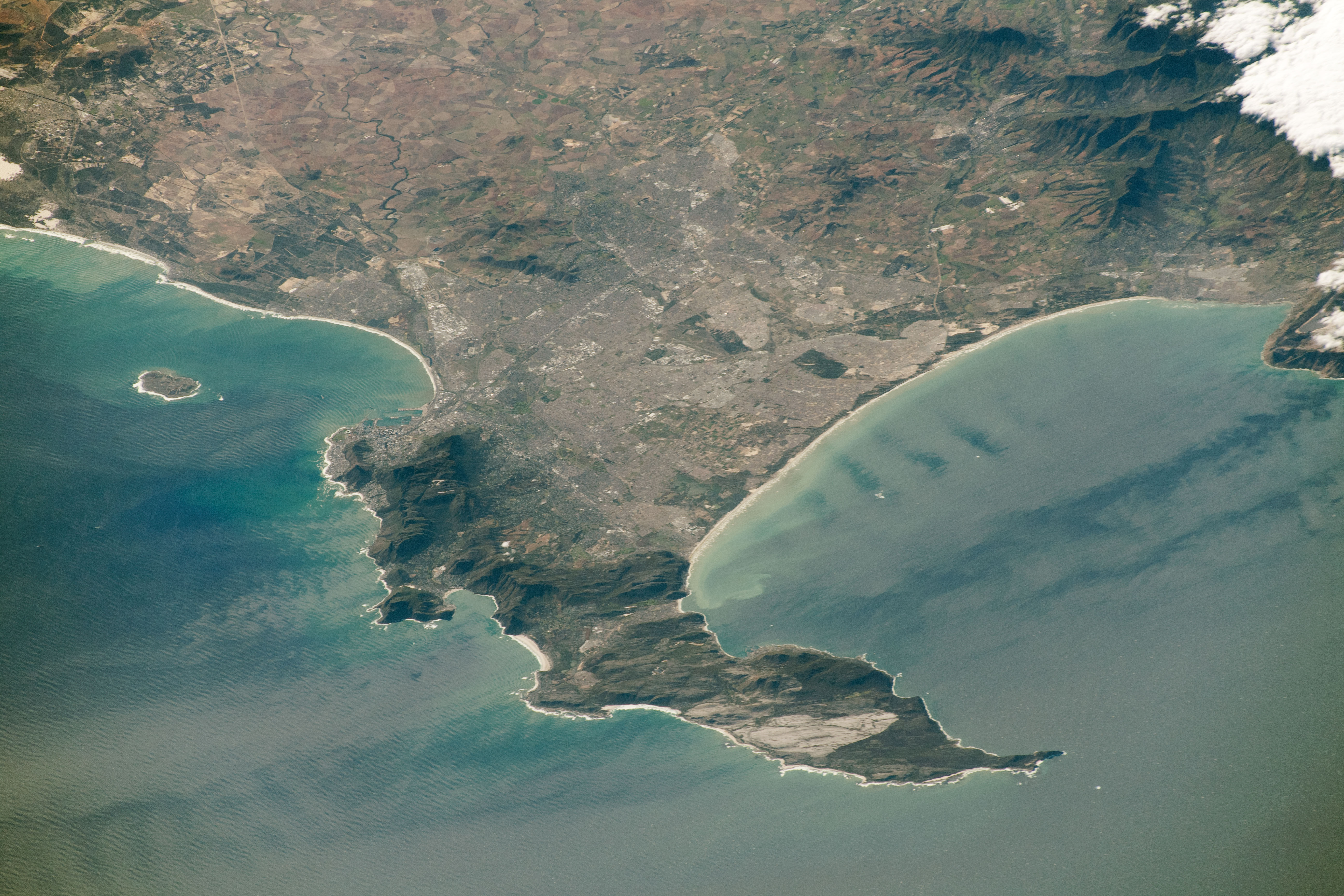
The Cape Peninsula ( af, Kaapse Skiereiland) is a generally mountainous peninsula that juts out into the Atlantic Ocean at the south-western extremity of the African continent. At the southern end of the peninsula are Cape Point and the Cape of Good Hope. On the northern end is Table Mountain, overlooking Table Bay and the city bowl of Cape Town, South Africa. The peninsula is 52 km long from Mouille point in the north to Cape Point in the south. The Peninsula has been an island on and off for the past 5 million years, as sea levels fell and rose with the Glacial period, ice age and interglacial global warming cycles of, particularly, the Pleistocene. The last time that the Peninsula was an island was about 1.5 million years ago. Soon afterwards it was joined to the mainland by the Geology of Cape Town#Tertiary to Recent events, emergence from the sea of the sandy area now known as the Cape Flats. The towns and villages of the Cape Peninsula and Cape Flats, and the ... [...More Info...] [...Related Items...] OR: [Wikipedia] [Google] [Baidu] |


