|
Rosso
Rosso is the major city of south-western Mauritania and capital of Trarza region. It is situated on the Senegal River at the head of the river zone allowing year-round navigation. The town is 204 km south of the capital Nouakchott. The Arabic name is Al-Quwarib. History Rosso was once the capital of the Emirate of Trarza, a Precolonial Sahrawi dominated state in Africa. Under French colonial rule Senegal and Mauritania were administered as a single entity. When independence came, the new frontier was drawn along the Senegal River, thus splitting the small town of Rosso in two. This article refers to Mauritanian Rosso, on the northern bank of the river. Originally a staging-post for the gum arabic trade, Rosso has grown rapidly since independence. From a population of a mere 2 300 in 1960 it has now overtaken Kaédi to become the 3rd largest city in the country with 48 922 inhabitants (2000 census). Languages Southwestern Mauritania is predominantly a Wolof-spea ... [...More Info...] [...Related Items...] OR: [Wikipedia] [Google] [Baidu] |
Trarza
Trarza ( ar, ولاية الترارزة) is a region in southwest Mauritania. Its capital is Rosso. Other major cities and towns include Mederdra and Boutilimit. Trarza borders the regions of Inchiri and Adrar to the north, Brakna to the east, and the country of Senegal to the south. Its western coastline on the Atlantic Ocean is interrupted only by the Mauritanian capital Nouakchott, which the region completely surrounds. In 2013, the population of the region was 272,773, compared to 345,076 in 2011. There were 47.79 per cent females and 52.21 per cent males. In 2008, the activity rate was 42.60 and economic dependency ratio was 0.99. The literacy rate for people aged 15 years and over was 79.0 per cent. Demographics In 2013, the population of the region was 272,773, compared to 345,076 in 2011. There were 47.79 per cent females and 52.21 per cent males. In 2008, the Couples with children was 35.10 and Couples without children was 3.70. The proportion with extended family was ... [...More Info...] [...Related Items...] OR: [Wikipedia] [Google] [Baidu] |
Mauritania–Senegal Border
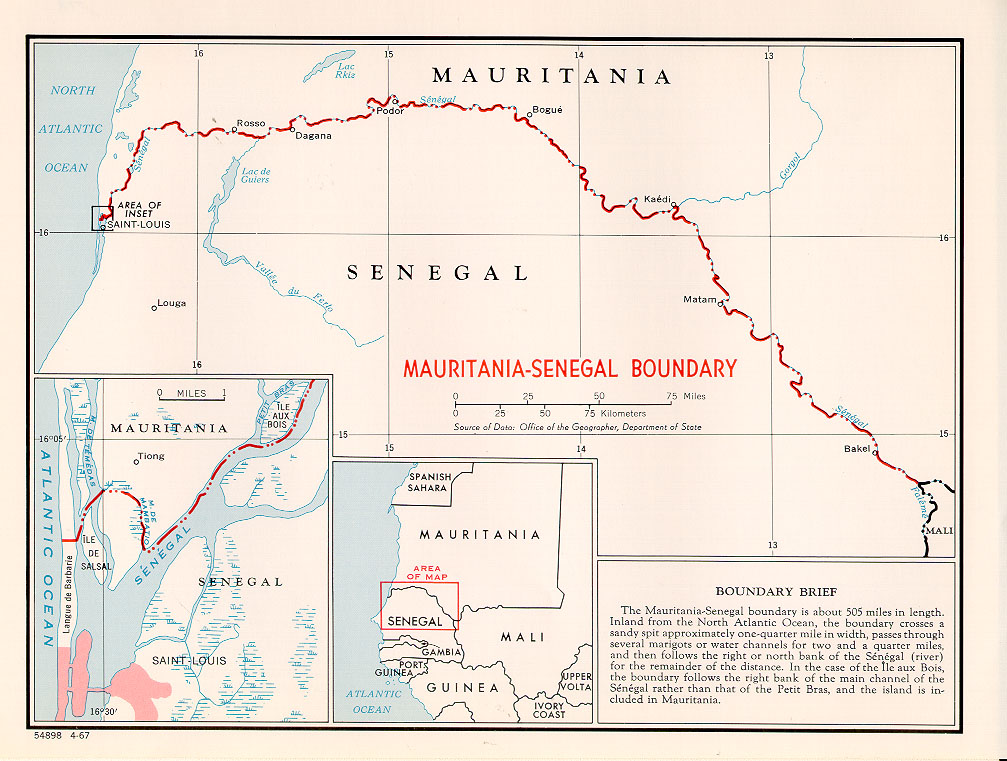
The Mauritania–Senegal border is 742 km (461 m) in length and runs from the Atlantic Ocean in the west along the Senegal River to the tripoint with Mali in the east. Description The border starts in the west at the Atlantic coast and then goes east, crossing the Langue de Barbarie spit, and then veers north, utilising the Marigot de Mambatio, before reaching the Senegal river. The border then follows this river eastwards in a broad arc, terminating at the Mali tripoint at the Senegal/Falémé confluence. History France had begun settling on the coasts of modern Mauritania and Senegal in the 17th-18th centuries, gradually extended their rule further inland as far as modern Mali during the 1850s-80s. As a result of the ‘Scramble for Africa’ in the 1880s, France gained control the upper valley of the Niger River (roughly equivalent to the areas of modern Mali and Niger). France occupied this area in 1900, followed by Mauritania in 1903–04. Mali (then referred to as Fren ... [...More Info...] [...Related Items...] OR: [Wikipedia] [Google] [Baidu] |
Senegal River
,french: Fleuve Sénégal) , name_etymology = , image = Senegal River Saint Louis.jpg , image_size = , image_caption = Fishermen on the bank of the Senegal River estuary at the outskirts of Saint-Louis, Senegal , map = Senegalrivermap.png , map_size = , map_caption = Map of the Senegal River drainage basin. , pushpin_map = , pushpin_map_size = , pushpin_map_caption= , subdivision_type1 = Country , subdivision_name1 = Senegal, Mauritania, Mali , subdivision_type2 = , subdivision_name2 = , subdivision_type3 = , subdivision_name3 = , subdivision_type4 = , subdivision_name4 = , subdivision_type5 = , subdivision_name5 = , length = , width_min = , width_avg = , width_max = , depth_min = , depth_avg = , depth_max = , discharge1_location= , discharge1_min = , discharge1_avg = , di ... [...More Info...] [...Related Items...] OR: [Wikipedia] [Google] [Baidu] |
Emirate Of Trarza
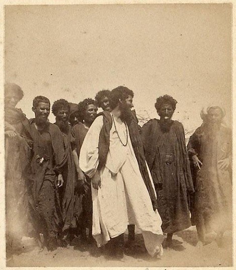
The Emirate of Trarza was a precolonial state in what is today southwest Mauritania. It has survived as a traditional confederation of semi-nomadic peoples to the present day. Its name is shared with the modern Region of Trarza. The population, a mixture of Berber tribes, had been there for a long time before being conquered in the 11th century by Hassaniya Arabic speakers from the north. Europeans later called these people Moors/''Maures'', and thus have titled this group "the Trarza Moors". Early history Trarza, founded in the midst of the final wars between the local Berber Bedouins and the Arab conquerors of the Maghreb, was organized as a semi-nomadic state led by a Muslim prince, or emir. Trarza was one of three powerful emirates that controlled the northwest bank of the Senegal River from the 17th to the 19th centuries CE; the others were the emirates of Brakna, and the Tagant. Society and structure The Arab conquests had resulted in a society divided according to ... [...More Info...] [...Related Items...] OR: [Wikipedia] [Google] [Baidu] |
Nouakchott
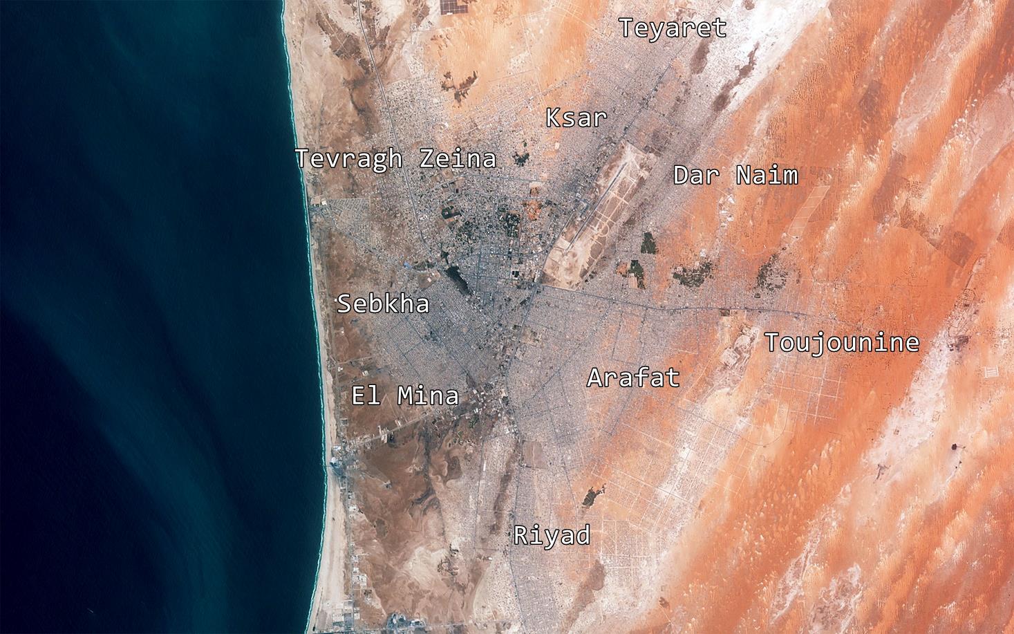
, image_skyline = Nouakchott.jpg , image_caption = City view of Nouakchott , pushpin_map = Mauritania#Arab world#Africa , pushpin_relief = 1 , mapsize = , map_caption = Map of Mauritania showing Nouakchott , subdivision_type = Country , subdivision_name = , subdivision_type1 = Capital district , subdivision_name1 = Nouakchott , leader_title = Council president , leader_name = Fatimatou Abdel Malick , population_as_of = 2019 census , population_total = 1,195,600 , area_total_km2 = 1000 , population_density_km2 = auto , area_total_sq_mi = 400 , coordinates = , coordinates_footnotes = , elevation_m = 7 , elevation_ft = , website = , settlement_type = Capital city Nouakchott (; ; ar, نواكشوط; ber, label= Berber, ital ... [...More Info...] [...Related Items...] OR: [Wikipedia] [Google] [Baidu] |
Communes Of Mauritania
There are 216 administrative communes of Mauritania recognised by the Government of Mauritania. Urban Agricultural * Adel Bagrou * Aere Mbar * Aghchorguitt * Ain Ehel Taya * Aioun * Ajar * Aleg * Amourj * Aoueinat Zbel * Aoujeft * Arr * Atar * Azgueilem Tiyab * Bababe * Bagrou * Barkeol * Bassiknou * Bethet Meit * Boghé * Bokkol * Bou Lahrath * Bougadoum * Bouheida * Bouhdida * Boulenoir * Bouly * Boumdeid * Bousteila * Boutilimitt * Cheggar * Chinguitti * Dafor * Daghveg * Dar El Barka * Dionaba * Djeol * Djiguenni * El Ghabra * El Ghaire * Fassala * Foum Gleita * Ghabou * Gouraye * Gueller * Guerou * Hamod * Hassichegar * Jidr-El Mouhguen * Kaédi * Kamour * Kankossa * Keur-Macene * Kobeni * Koumbi Saleh * Lahraj * Legrane * Leouossy * Lexeiba * Maghama * Magta-Lahjar * Male * Mbagne * Mbalal * Mbout * Mederdra * Monguel * Moudjeria * Nbeika * Ndiago * Néma * Niabina * Noual * Ouad Naga * Ouadane * Oualata * Oueid Jrid * O ... [...More Info...] [...Related Items...] OR: [Wikipedia] [Google] [Baidu] |
Mauritania
Mauritania (; ar, موريتانيا, ', french: Mauritanie; Berber: ''Agawej'' or ''Cengit''; Pulaar: ''Moritani''; Wolof: ''Gànnaar''; Soninke:), officially the Islamic Republic of Mauritania ( ar, الجمهورية الإسلامية الموريتانية), is a sovereign country in West Africa. It is bordered by the Atlantic Ocean to the west, Western Sahara to the north and northwest, Algeria to the northeast, Mali to the east and southeast, and Senegal to the southwest. Mauritania is the 11th-largest country in Africa and the 28th-largest in the world, and 90% of its territory is situated in the Sahara. Most of its population of 4.4 million lives in the temperate south of the country, with roughly one-third concentrated in the capital and largest city, Nouakchott, located on the Atlantic coast. The country's name derives from the ancient Berber kingdom of Mauretania, located in North Africa within the ancient Maghreb. Berbers occupied what is now Mauritania ... [...More Info...] [...Related Items...] OR: [Wikipedia] [Google] [Baidu] |
Regions Of Mauritania
Mauritania is divided into 15 regions: During the Mauritanian occupation of Western Sahara (1975–79), its portion of the territory (roughly corresponding to the lower half of Río de Oro province) was named Tiris al-Gharbiyya. The regions are subdivided into 44 departments; see departments of Mauritania The Regions of Mauritania are subdivided into 44 departments. The departments are listed below, by region: Adrar Region * Atar Department * Chinguetti Department * Oujeft Department * Ouadane Department Assaba Region * Aftout Department ... for more information. See also * ISO 3166-2:MR {{Mauritania topics Mauritania 1 Regions, Mauritania Mauritania, Regions Mauritania geography-related lists Subdivisions of Mauritania * Mauritania ... [...More Info...] [...Related Items...] OR: [Wikipedia] [Google] [Baidu] |
French West Africa
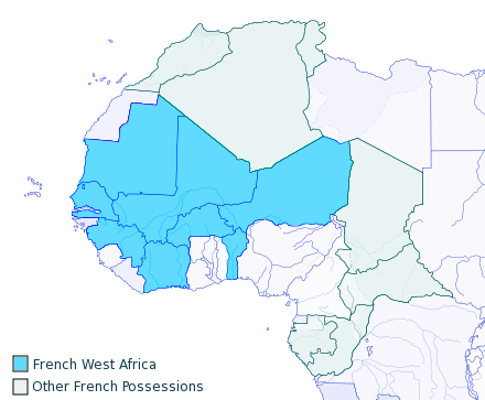
French West Africa (french: Afrique-Occidentale française, ) was a federation of eight French colonial territories in West Africa: Mauritania, Senegal, French Sudan (now Mali), French Guinea (now Guinea), Ivory Coast, Upper Volta (now Burkina Faso), Dahomey (now Benin) and Niger. The federation existed from 1895 until 1958. Its capital was Saint-Louis, Senegal until 1902, and then Dakar until the federation's collapse in 1960. History Until after World War II, almost none of the Africans living in the colonies of France were citizens of France. Rather, they were "French subjects", lacking rights before the law, property ownership rights, rights to travel, dissent, or vote. The exception was the Four Communes of Senegal: those areas had been towns of the tiny Senegal Colony in 1848 when, at the abolition of slavery by the French Second Republic, all residents of France were granted equal political rights. Anyone able to prove they were born in these towns was legally Fre ... [...More Info...] [...Related Items...] OR: [Wikipedia] [Google] [Baidu] |
History Of Mauritania
The original inhabitants of Mauritania were the Bafour, presumably a Mande ethnic group, connected to the contemporary Arabized minor social group of '' Imraguen'' ("fishermen") on the Atlantic coast. The territory of Mauritania was on the fringe of geographical knowledge of Libya in classical antiquity. Berber immigration took place from about the 3rd century. Mauritania takes its name from the ancient Berber kingdom and later Roman province of Mauretania, and thus ultimately from the Mauri people, even though the respective territories do not overlap, historical Mauritania being considerably further north than modern Mauritania. The Umayyads were the first Arab Muslims to enter Mauritania. During the Islamic conquests, they made incursions into Mauritania and were present in the region by the end of the 7th century. Many Berber tribes in Mauritania fled the arrival of the Arabs to the Gao region in Mali. The European colonial powers of the 19th century had little interest ... [...More Info...] [...Related Items...] OR: [Wikipedia] [Google] [Baidu] |
Regional Capitals In Mauritania
In geography, regions, otherwise referred to as zones, lands or territories, are areas that are broadly divided by physical characteristics (physical geography), human impact characteristics (human geography), and the interaction of humanity and the environment (environmental geography). Geographic regions and sub-regions are mostly described by their imprecisely defined, and sometimes transitory boundaries, except in human geography, where jurisdiction areas such as national borders are defined in law. Apart from the global continental regions, there are also hydrospheric and atmospheric regions that cover the oceans, and discrete climates above the land and water masses of the planet. The land and water global regions are divided into subregions geographically bounded by large geological features that influence large-scale ecologies, such as plains and features. As a way of describing spatial areas, the concept of regions is important and widely used among the many branches of ... [...More Info...] [...Related Items...] OR: [Wikipedia] [Google] [Baidu] |
United States Peace Corps
The Peace Corps is an independent agency and program of the United States government that trains and deploys volunteers to provide international development assistance. It was established in March 1961 by an executive order of President John F. Kennedy Executive Order 10924 and authorized by Congress the following September by the Peace Corps Act. Kennedy first publicly proposed the Peace Corps during his 1960 presidential campaign as a means to improve America's global image and leadership in the Cold War; he cited the Soviet Union's deployment of skilled citizens "abroad in the service of world communism" and argued the U.S. must do the same to advance values such as democracy and liberty. The Peace Corps was formally established within three months of Kennedy's presidency, garnering both bipartisan congressional support and popular support, particularly among recent university graduates. The official goal of the Peace Corps is to assist developing countries by providing skil ... [...More Info...] [...Related Items...] OR: [Wikipedia] [Google] [Baidu] |


