|
MauritaniaŌĆōSenegal Border
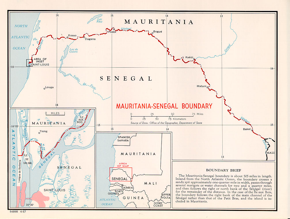
The MauritaniaŌĆōSenegal border is 742 km (461 m) in length and runs from the Atlantic Ocean in the west along the Senegal River to the tripoint with Mali in the east. Description The border starts in the west at the Atlantic coast and then goes east, crossing the Langue de Barbarie spit, and then veers north, utilising the Marigot de Mambatio, before reaching the Senegal river. The border then follows this river eastwards in a broad arc, terminating at the Mali tripoint at the Senegal/Fal├®m├® confluence. History France had begun settling on the coasts of modern Mauritania and Senegal in the 17th-18th centuries, gradually extended their rule further inland as far as modern Mali during the 1850s-80s. As a result of the ŌĆśScramble for AfricaŌĆÖ in the 1880s, France gained control the upper valley of the Niger River (roughly equivalent to the areas of modern Mali and Niger). France occupied this area in 1900, followed by Mauritania in 1903ŌĆō04. Mali (then referred to as Fren ... [...More Info...] [...Related Items...] OR: [Wikipedia] [Google] [Baidu] |
Mauritania Senegal Border
Mauritania (; ar, ┘ģ┘łž▒┘Ŗž¬ž¦┘å┘Ŗž¦, ', french: Mauritanie; Berber languages, Berber: ''Agawej'' or ''Cengit''; Pulaar language, Pulaar: ''Moritani''; Wolof language, Wolof: ''G├Ānnaar''; Soninke language, Soninke:), officially the Islamic Republic of Mauritania ( ar, ž¦┘äž¼┘ģ┘ć┘łž▒┘Ŗž® ž¦┘äžźž│┘䞦┘ģ┘Ŗž® ž¦┘ä┘ģ┘łž▒┘Ŗž¬ž¦┘å┘Ŗž®), is a sovereign country in West Africa. It is bordered by the Atlantic Ocean to the west, Western Sahara to MauritaniaŌĆōWestern Sahara border, the north and northwest, Algeria to AlgeriaŌĆōMauritania border, the northeast, Mali to MaliŌĆōMauritania border, the east and southeast, and Senegal to MauritaniaŌĆōSenegal border, the southwest. Mauritania is the 11th-largest country in Africa and the 28th-largest in the world, and 90% of its territory is situated in the Sahara. Most of its population of 4.4 million lives in the temperate south of the country, with roughly one-third concentrated in the Capital city, capital and largest city, Nouakchott, loca ... [...More Info...] [...Related Items...] OR: [Wikipedia] [Google] [Baidu] |
MauritaniaŌĆōSenegal Border War
The MauritaniaŌĆōSenegal Border War was a conflict fought between the West African countries of Mauritania and Senegal along their shared border during 1989ŌĆō1991. The conflict began around disputes over the two countries' River Senegal border and grazing rights, and resulted in the rupture of diplomatic relations between the two countries for several years, the creation of thousands of refugees from both sides, as well as having a significant impact on domestic Senegalese politics. Background Mauritania's south is mostly populated by the Fula/ Toucouleur, Wolof, and Sonink├®. Senegal, meanwhile, is dominated by the Wolof. The Senegal River basin between Mauritania and Senegal has for centuries been inhabited by both black populations, such as the Fula/Toucouleur, Wolof, Bambara, and Sonink├®, and by Arabs and Berber peoples. Periods of drought throughout the 1980s increased tensions over available arable land, with the basin becoming even more important because of develop ... [...More Info...] [...Related Items...] OR: [Wikipedia] [Google] [Baidu] |
Matam, Senegal
Matam (Hassaniya Arabic: ; Wolof: Mataam) is the capital town of the Matam Region in north-east Senegal, and lies on the S├®n├®gal River on the border with Mauritania. In the census of 2002, Matam had 14,620 inhabitants. In 2007, according to official estimates, the population of the town had increased to 17,324. In 1996, the Upper Senegal River Valley, stretching from Matam to Diamou in Mali was cited as one of the poorest and most inaccessible regions in the western Sahel. Mining Matam has phosphate mines in the vicinity. Climate Matam has a hot desert climate (BWh) with little to no rainfall in all months except July, August and September. Notable people *Samba Diould├® Thiam Samba Diould├® Thiam is a Senegalese politician from Matam. He is a member of the National Assembly of Senegal. See also *Politics of Senegal Politics in Senegal takes place within the framework of a presidential democratic republic. The Pr ... References Populated places in Mat ... [...More Info...] [...Related Items...] OR: [Wikipedia] [Google] [Baidu] |
Sioure
Sioure is a town in the Podor Department of the Saint-Louis Region in Senegal, West Africa. It is situated on the left bank of the Senegal River, located on the border with Mauritania, on the island of Morfil about 250 km (150 miles) from the Atlantic Ocean. Sioure has an estimated population of 2,550, all of whom are Haal'Pulaar'en or speakers of the Fula language, Pulaar. The main economic activities are farming, both arable and pastoral, and fishing. Formerly, the arable farming was based around the flooding of the river in the wet season, and involved beans, potatoes and tomatoes. Since the droughts of the 1970s, most farming is now in irrigated fields, and the main crops are rice, corn and sorghum. The town has a school with six classes, a health centre and a mosque A mosque (; from ar, ┘ģ┘Äž│┘Æž¼┘Éž», masjid, ; literally "place of ritual prostration"), also called masjid, is a place of prayer for Muslims. Mosques are usually covered buildings, but can be any p ... [...More Info...] [...Related Items...] OR: [Wikipedia] [Google] [Baidu] |
Podor
Podor (Wolof: Podoor) is the northernmost town in Senegal, lying on Morfil Island between the S├®n├®gal River and Dou├® River on the border with Mauritania. It was the location of the ancient state Takrur. It is home to a ruined French colonial fort, built in 1854 as a centre for gold trading, and is the birthplace of fashion designer Oumou Sy, as well as musicians Baaba Maal and Mansour Seck. The 2002 census determined the population of the town was 9,472 inhabitants. In 2007, according to official estimates, it had grown to 11,869. It is 99% Muslim Muslims ( ar, ž¦┘ä┘ģž│┘ä┘ģ┘ł┘å, , ) are people who adhere to Islam, a monotheistic religion belonging to the Abrahamic tradition. They consider the Quran, the foundational religious text of Islam, to be the verbatim word of the God of Abrah .... References Populated places in Saint-Louis Region Communes of Senegal {{Senegal-geo-stub ... [...More Info...] [...Related Items...] OR: [Wikipedia] [Google] [Baidu] |
Dagana, Senegal
Dagana is a town situated in the Saint-Louis Region of Senegal and it is the capital of the Dagana Department. Dagana shares its border with Mauritania. The different ethnic groups in Dagana include Wolof, Fula ( ff, Ful╔ōe; french: Peul ''or'' Peulh), and Moor Moor or Moors may refer to: Nature and ecology * Moorland, a habitat characterized by low-growing vegetation and acidic soils. Ethnic and religious groups * Moors, Muslim inhabitants of the Maghreb, Iberian Peninsula, Sicily, and Malta during .... Populated places in Saint-Louis Region Saint-Louis Region Communes of Senegal {{Senegal-geo-stub ... [...More Info...] [...Related Items...] OR: [Wikipedia] [Google] [Baidu] |
Saint-Louis, Senegal
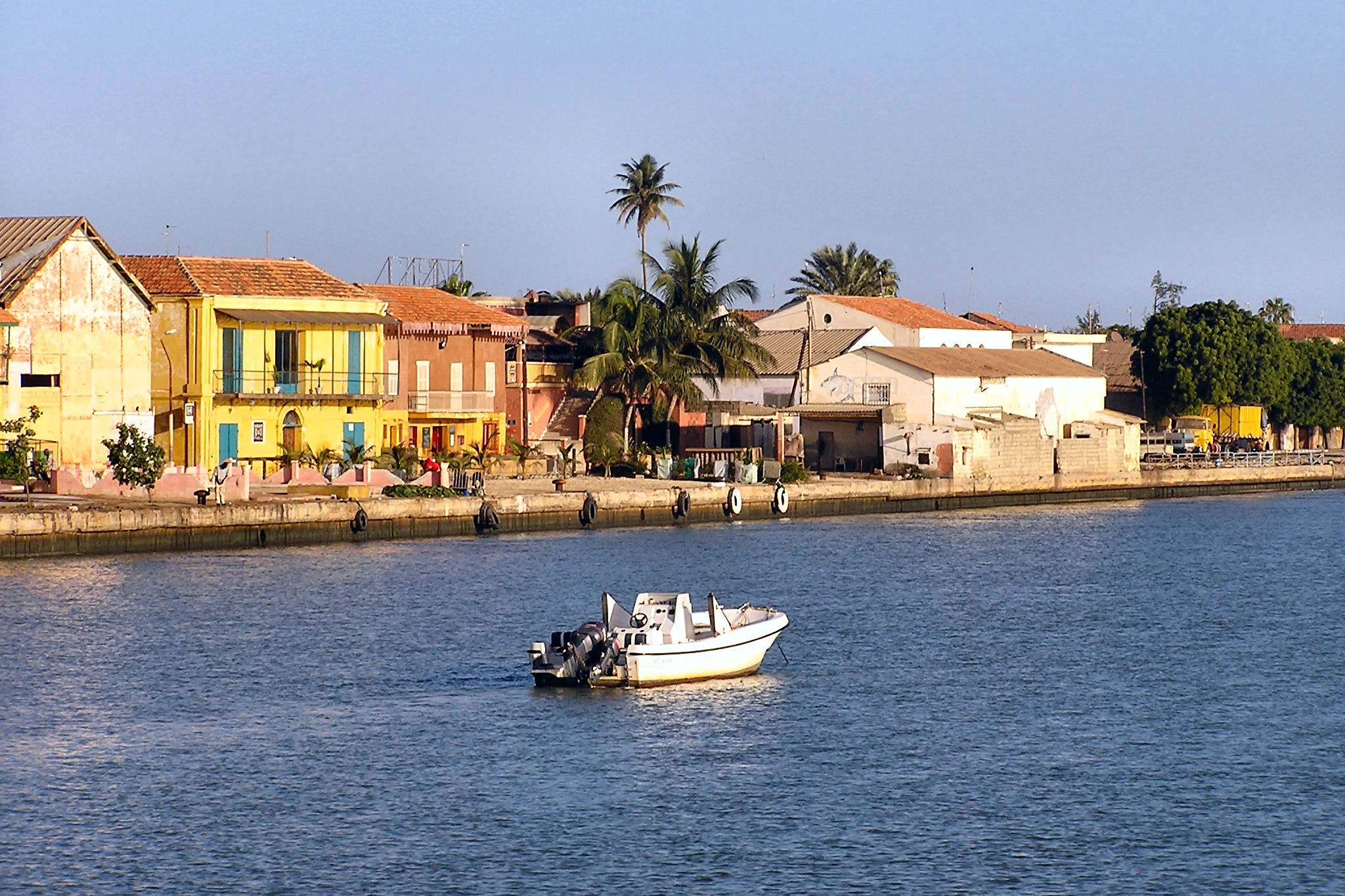
Saint Louis or Saint-Louis ( wo, Ndar), is the capital of Senegal's Saint-Louis Region. Located in the northwest of Senegal, near the mouth of the Senegal River, and 320 km north of Senegal's capital city Dakar, it has a population officially estimated at 258,592 in 2021. Saint-Louis was the capital of the French colony of Senegal from 1673 until 1902 and French West Africa from 1895 until 1902, when the capital was moved to Dakar. From 1920 to 1957, it also served as the capital of the neighboring colony of Mauritania. The town was an important economic center during French West Africa, but it is less important now. However it still has important industries, including tourism, a commercial center, a center of sugar production, and fishing. The Tourism industry is in part due to the city being listed as a UNESCO World Heritage Site in 2000. However, the city is also Climate change vulnerability, vulnerable to climate changeŌĆöwhere sea level rise is expected to threaten the ci ... [...More Info...] [...Related Items...] OR: [Wikipedia] [Google] [Baidu] |
Sagne, Mauritania
Sagne is a village and Communes of Mauritania, rural commune in Mauritania, located on the MauritaniaŌĆōSenegal border, border with Senegal. Communes of Mauritania {{Mauritania-geo-stub ... [...More Info...] [...Related Items...] OR: [Wikipedia] [Google] [Baidu] |
Ka├®di
Ka├®di ( ar, ┘ā┘Ŗ┘ć┘Ŗž»┘Ŗ) is the largest city and administrative center of the Gorgol Region of Southern Mauritania, located on the border with Senegal. It is approximately 435 km from Mauritania's capital, Nouakchott. Overview The city sits within the " Chemama" Riverine zone along the north bank of the River Senegal where it connects with the Gorgol River. This region is one of the few areas of settled agriculture in the country. Culturally, the city is among the most diverse in Mauritania, consisting of ethnic "White Moors" (Arabic: ž¦┘äž©┘ŖžČž¦┘å) and "Black Moors" (Arabic: ž¦┘äž│┘łž»ž¦┘å), as well as Pulaar, and Soninke communities. It is known as a market town, a medical centre, and a centre for local farmers. The market reflects the sub-Saharan culture of neighboring Senegal somewhat more than the Moorish-Arabic culture found further north in the country. Most of the architecture consists of brown, flat-roofed buildings, undistinguished except that most are su ... [...More Info...] [...Related Items...] OR: [Wikipedia] [Google] [Baidu] |
Mbagne
Mbagne is a town and commune in the Brakna Region of southern Mauritania on the border with Senegal. Mbagne has a high unemployment rate and an unstable agriculture system, according to the OECD The Organisation for Economic Co-operation and Development (OECD; french: Organisation de coop├®ration et de d├®veloppement ├®conomiques, ''OCDE'') is an intergovernmental organisation with 38 member countries, founded in 1961 to stimulate e .... In 2000 it had a population of 10,383. References Communes of Brakna Region {{Mauritania-geo-stub ... [...More Info...] [...Related Items...] OR: [Wikipedia] [Google] [Baidu] |
Babab├®
Babab├® is a town and commune in the Brakna Region of southern Mauritania, located on the border with Senegal Senegal,; Wolof: ''Senegaal''; Pulaar: ׿ģ׿½×ż▓׿½×ż║׿óןä׿ż×żŁ (Senegaali); Arabic: ž¦┘äž│┘åž║ž¦┘ä ''As-Sinighal'') officially the Republic of Senegal,; Wolof: ''R├®ewum Senegaal''; Pulaar : ׿ł×ż½×ż▓׿Ż×żóןä׿▓׿Ż×żŁ .... In 2000 it had a population of 11,802. References Communes of Brakna Region {{Mauritania-geo-stub ... [...More Info...] [...Related Items...] OR: [Wikipedia] [Google] [Baidu] |
Bogh├®
Bogh├® (also Bogu├®) is a town and commune in the Brakna Region of southern Mauritania, located on the border with Senegal Senegal,; Wolof: ''Senegaal''; Pulaar: ׿ģ׿½×ż▓׿½×ż║׿óןä׿ż×żŁ (Senegaali); Arabic: ž¦┘äž│┘åž║ž¦┘ä ''As-Sinighal'') officially the Republic of Senegal,; Wolof: ''R├®ewum Senegaal''; Pulaar : ׿ł×ż½×ż▓׿Ż×żóןä׿▓׿Ż×żŁ × .... In 2013, it had a census population of 40,341. The city has a high school but no university. Efforts are under way to build a hospital to serve the city and its region. Climate In Bogh├®, the climate is warm and temperate. There is little rainfall. The K├Čppen-Geiger climate classification is BSh. The average annual temperature in Boghe is . About of precipitation falls annually. References Communes of Brakna Region {{Mauritania-geo-stub ... [...More Info...] [...Related Items...] OR: [Wikipedia] [Google] [Baidu] |


