|
Rail Transport In Burkina Faso
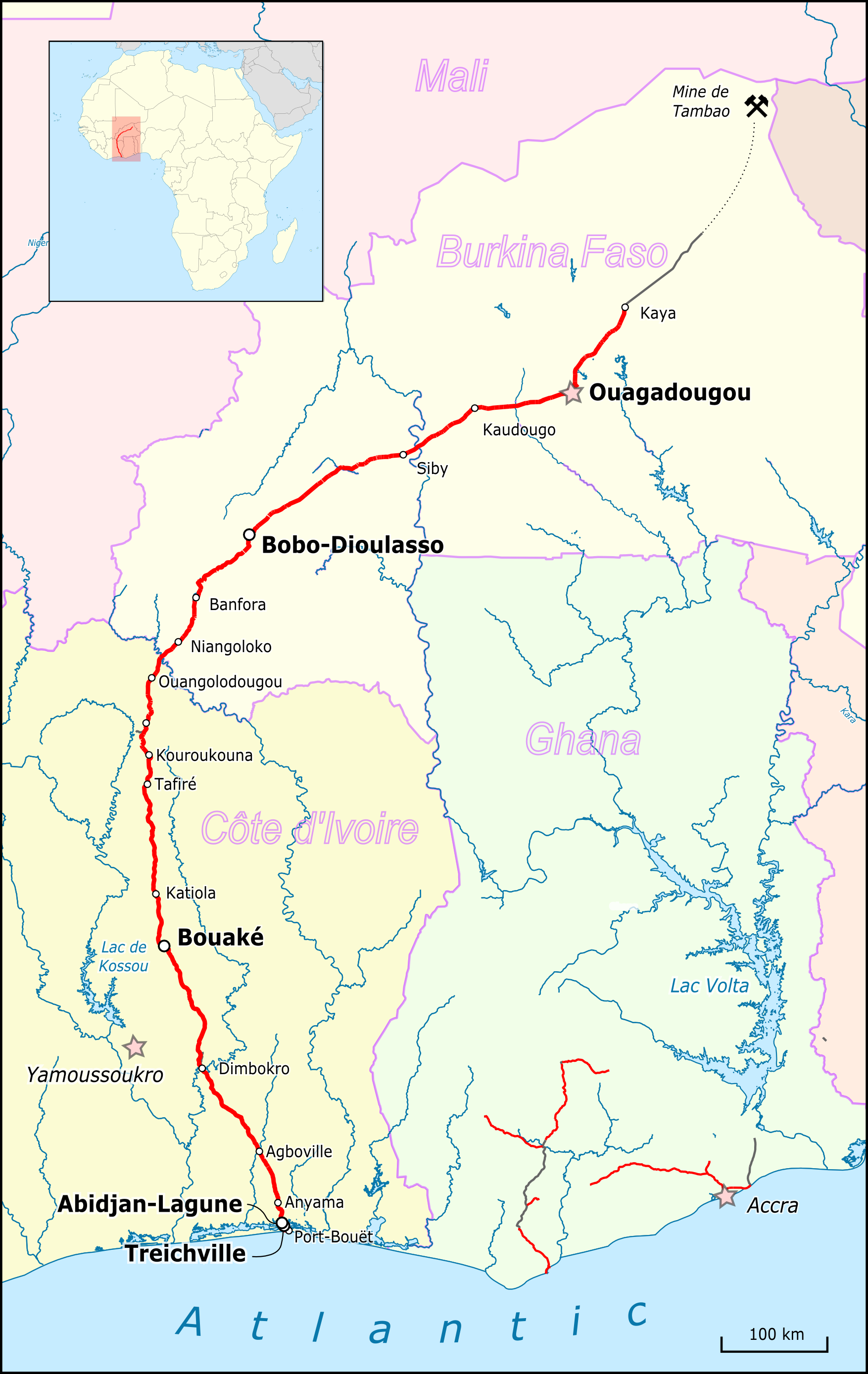
There are 622 kilometres of railway in Burkina Faso, which run from Kaya to the border with Côte d'Ivoire and is part of the Abidjan-Ouagadougou railway. As of June 2014, 'Sitarail' operates a passenger train three times a week along the route from Ouagadougou to Abidjan. Journey time is 43 to 48 hours. Burkina Faso is landlocked, but the railway to Abidjan provides rail access to a port. Links to railways in Ghana and the port of Takoradi have been repeatedly proposed. Stations The following towns of Burkina Faso are served by the country's railways: * - - border * Niangoloko * Banfora * Peni * Bobo-Dioulasso * Sala * Koudougou * Bingo * Ouagadougou (national capital) * Ziniaré (service suspended) * Kaya terminus Construction resuming * (for 3MTpa manganese - 2014)? * Kaya (terminus) * Dori (approx. 100 km of the extension from Kaya to Dori; visible on Google Earth dated 15/2/07) * Markoye * Tambao (manganese), near Niger/Mali borders Proposed * ( gauge) ... [...More Info...] [...Related Items...] OR: [Wikipedia] [Google] [Baidu] |
Abidjan-Ouagadougou Railway
The Abidjan-Niger Railway is a single-track metre gauge line in francophone West Africa that links Abidjan, the economic capital of Ivory Coast to Ouagadougou, the capital of Burkina Faso. The railway, like others on the continent, was constructed by the colonial power to encourage economic development in the region, although detractors would claim that it was to exploit the region solely for their own advantage. Although the railway was once the predominant transporter of passengers in the region, by 2000 it was facing strong competition from road transport. Now, the railway's main role is servicing international freight traffic (petroleum products, containers, fertilizers, grain, clinker, cement, cotton etc) to and from Burkina Faso and the north of Côte d'Ivoire. Communities served A passenger train still runs three times a week, on Tuesdays, Thursdays and Saturdays. The journey has been reported to take from 36 to 48 hours. The passenger train serves the following stat ... [...More Info...] [...Related Items...] OR: [Wikipedia] [Google] [Baidu] |
Sala, Houet
Sala is a town in central Burkina Faso. It is in Satiri Department, Houet Province, Hauts-Bassins Region. Transport It is served by a station on the Abidjan-Niger Railway The Abidjan-Niger Railway is a single-track metre gauge line in francophone West Africa that links Abidjan, the economic capital of Ivory Coast to Ouagadougou, the capital of Burkina Faso. The railway, like others on the continent, was constructe .... See also * Railway stations in Burkina Faso References Populated places in the Hauts-Bassins Region {{Houet-geo-stub ... [...More Info...] [...Related Items...] OR: [Wikipedia] [Google] [Baidu] |
Bagré Village
Bagré (or ''Bagré-Village'') is a village and seat of the Bagré Department Bagré is a department or commune of Boulgou Province in eastern Burkina Faso. Its capital lies at the town of Bagré. According to the 2006 census, actualized for the municipal élections of 2013, the department has a total population of 29,16 ... of Boulgou Province in south-eastern Burkina Faso. As of 2012, the village has a population of 4,993. References {{DEFAULTSORT:Bagre Populated places in the Centre-Est Region Boulgou Province ... [...More Info...] [...Related Items...] OR: [Wikipedia] [Google] [Baidu] |
Bolgatanga
Bolgatanga ( Frafra: ''''), colloquially known as ''Bolga'', is a town and the capital of the Bolgatanga Municipal District and Upper East Region of Ghana, adjacent to the border with Burkina Faso. Bolgatanga has over 2012 settlement and a population of about 66,685 people. Bolgatanga is 161 km (about 100 miles) to the north of Tamale. Bolgatanga lies in the Red Volta River Valley (which serves as a major migration route of elephants), with the White Volta River and the cliffs of the Gambaga Escarpment to the south of the town forming the southern boundary of the Upper East Region. History of Bolgatanga The name Bolgatanga (Bolbatanga) was derived from the Guresi words ''bolba'' "migrants" and ''tanŋa'' "pyramid." Historically Bolgatanga was situated at the southern terminus of the ancient Trans-Saharan trade route. The eastern route converged with the Sahelian route, near Bolgatanga. Along the route, handicrafts—especially straw baskets, hats and fans, as well as leat ... [...More Info...] [...Related Items...] OR: [Wikipedia] [Google] [Baidu] |
Navrongo
Navrongo is a town and the capital of Kassena-Nankana District in the Upper East Region of northern Ghana, adjacent to the border with Burkina Faso. Navrongo is the capital of Kassena-Nankana District – which is within the Upper East Region of northern Ghana. Navrongo has a 2012 settlement population of 27,306 people. Navrongo is an important market town, known for its cathedral and its grotto. Navrongo is located at . Navrongo's population in 2005 was estimated to be 25,470, and its population in 2012 was estimated to be 27,306. The terrain is flat and the ecology is typical of the Sahel – arid grassland with occasional shrubbery. The first ever Solar Plant with a capacity of 2 Megawatts in Ghana is located at Navrongo: Navrongo Solar Power Station. ''ghana.gov.gh''. History The ...[...More Info...] [...Related Items...] OR: [Wikipedia] [Google] [Baidu] |
Mali
Mali (; ), officially the Republic of Mali,, , ff, 𞤈𞤫𞤲𞥆𞤣𞤢𞥄𞤲𞤣𞤭 𞤃𞤢𞥄𞤤𞤭, Renndaandi Maali, italics=no, ar, جمهورية مالي, Jumhūriyyāt Mālī is a landlocked country in West Africa. Mali is the eighth-largest country in Africa, with an area of over . The population of Mali is million. 67% of its population was estimated to be under the age of 25 in 2017. Its capital and largest city is Bamako. The sovereign state of Mali consists of eight regions and its borders on the north reach deep into the middle of the Sahara Desert. The country's southern part is in the Sudanian savanna, where the majority of inhabitants live, and both the Niger and Senegal rivers pass through. The country's economy centres on agriculture and mining. One of Mali's most prominent natural resources is gold, and the country is the third largest producer of gold on the African continent. It also exports salt. Present-day Mali was once part of t ... [...More Info...] [...Related Items...] OR: [Wikipedia] [Google] [Baidu] |
Niger
) , official_languages = , languages_type = National languagesRépublique du Niger, "Loi n° 2001-037 du 31 décembre 2001 fixant les modalités de promotion et de développement des langues nationales." L'aménagement linguistique dans le monde (accessed 21 September 2016) , languages = , religion_ref = , religion_year = 2012 , religion = , demonym = Nigerien , capital = , coordinates ... [...More Info...] [...Related Items...] OR: [Wikipedia] [Google] [Baidu] |
Tambao
Tambao is a Manganese deposit and potential mine site in the Oudalan Province, located in the Sahel Region, which the far northeastern part of Burkina Faso. Tambao has been estimated, when exploited, to be one of the largest deposits in the region. Its development, a major priority of the Burkinabe state, has been an on and off project since the 1990s. Barely served by roads or other infrastructure, the Tambao reserves are some north of Kaya and northeast of the capital, namely Ouagadougou. The Tambao Airport has been recently built to serve the deposit and the corresponding villages. Industry Manganese is mined here. For at least two decades it has been considered the most potentially lucrative mining resource in Burkina, and is believed the region's largest Manganese deposit, estimated at 20 million tonnes at %52 to %53 Manganese to ore, making it one of the cryptomelane-richest ore resources in the world. [...More Info...] [...Related Items...] OR: [Wikipedia] [Google] [Baidu] |
Markoye
Markoye is a town in northern Burkina Faso, in the province of Oudalan. It is the site of Burkina Faso’s coldest recorded temperature of . Economy There is a weekly cattle and camel A camel (from: la, camelus and grc-gre, κάμηλος (''kamēlos'') from Hebrew or Phoenician: גָמָל ''gāmāl''.) is an even-toed ungulate in the genus ''Camelus'' that bears distinctive fatty deposits known as "humps" on its back. C ... market in the town and it is close to a manganese mine in Tambao.Historical Dictionary of Burkina Faso, by Lawrence Rupley, Lamissa Bangali, Boureima Diamitani, 2013, Third edition, Scarecrow Press, Inc. Transport It is a station on a proposed phosphate railway. See also * Railway stations in Burkina Faso References External links Markoye, Under the Acacias Populated places in the Centre-Nord Region {{Oudalan-geo-stub ... [...More Info...] [...Related Items...] OR: [Wikipedia] [Google] [Baidu] |
Dori, Burkina Faso
Dori (also known as Winde or Wendu) is a town in northeastern Burkina Faso, near the border of Niger. It is located at around . It is the capital of Sahel Region and has a population of 46,512 (2019). The main ethnic group is the Fula (Fulani) but Tuaregs, Songhai, and Hausa people are often present. It is a town known for its herders and popular livestock markets. Dori recorded a temperature of in 1984, which is the highest temperature to have ever been recorded in Burkina Faso. Mines In 2004, a proposal surfaced to link the manganese mines by rail with the seaports of Ghana. Notable people * Roukiatou Maiga, humanitarian * Albert Ouédraogo, former Burkinabé Prime Minister See also * Railway stations in Burkina Faso Gallery File:ASC Leiden - van Achterberg Collection - 5 - 050 - Le vieux quartier de Dori avec ses habitants - Dori, Séno, Burkina Faso, 19-26 août 2001.tif, The old district of Dori with its inhabitants, 2001 File:ASC Leiden - van Achterberg Collect ... [...More Info...] [...Related Items...] OR: [Wikipedia] [Google] [Baidu] |

