|
Río Turbio
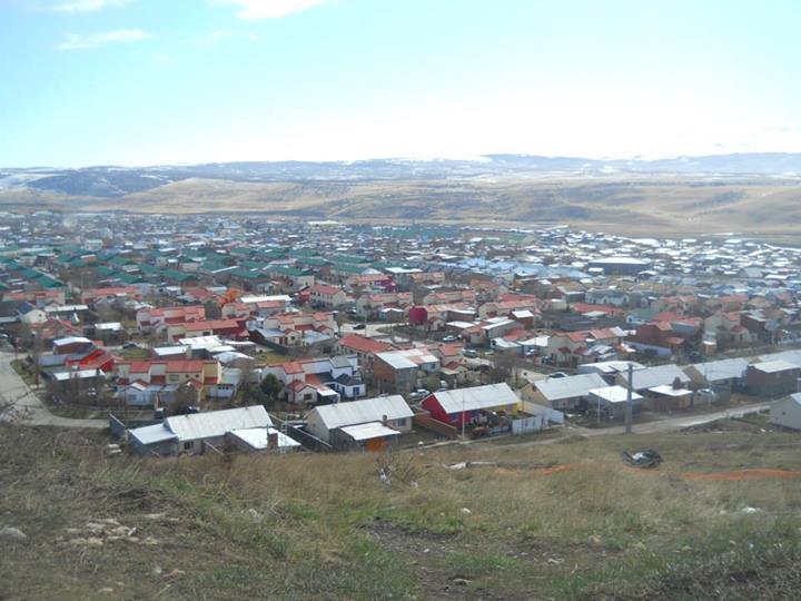
Río Turbio is a town and municipality in the Güer Aike Department of the Santa Cruz Province in southern Argentina. It was founded in late 1942, as a consequence of the coal mining in the area. Rio Turbio was home to the state-owned coal extraction company YCF. The mine is currently operated by Yacimientos Carboníferos Río Turbio. Río Turbio Airport is located near to 28 de Noviembre town, about 16 km southwest of Rio Turbio. Climate Under the Köppen climate classification, Río Turbio is classified as a subpolar oceanic climate (Köppen climate classification The Köppen climate classification is one of the most widely used climate classification systems. It was first published by German-Russian climatologist Wladimir Köppen (1846–1940) in 1884, with several later modifications by Köppen, notabl ...: Cfc) with cold winters. The climate is characterized by strong westerly winds, which are generated by the influence of the two semi-permanent high pressure s ... [...More Info...] [...Related Items...] OR: [Wikipedia] [Google] [Baidu] |
Yacimientos Carboníferos Río Turbio
Yacimientos Carboníferos Río Turbio (''Rio Turbio Coal Mines'', abbrevriated YCRT) is an Argentine coal mining company created in 1994 to replace Yacimientos Carboníferos Fiscales, along with the privatization of many other state-owned enterprises, the trademark of the national administration of the time. It was created to extract, ship and sell the coal from Rio Turbio and its coal basin. It is the only coal mine in all of Argentina and a geopolitical key are, since it is located in the south west extreme of the country, one of the furthest south settlements of the country. YCRT runs the Río Turbio coal mine, in the southern province of Santa Cruz, along the Andes border with Chile. It also has a rail line connecting to the Punta Loyola port, a 25 MW power station for internal use, and a 240 MW thermal power station (under construction) linked to the Argentinian Interconnection. It was a privately managed company between 1994 and 2002, when the government intervened it b ... [...More Info...] [...Related Items...] OR: [Wikipedia] [Google] [Baidu] |
Provinces Of Argentina
Argentina Argentina (), officially the Argentine Republic ( es, link=no, República Argentina), is a country in the southern half of South America. Argentina covers an area of , making it the second-largest country in South America after Brazil, t ... is subdivided into twenty-three federated states called provinces ( es, provincias, singular ''provincia'') and one called the autonomous city (''ciudad autónoma'') of Buenos Aires, which is the federal capital of the republic ( es, Capital Federal, links=no) as decided by the National Congress of Argentina, Argentine Congress. The provinces and the capital have their own constitutions, and exist under a federalism, federal system. History During the Argentine War of Independence, War of Independence the main cities and their surrounding countrysides became provinces though the intervention of their Cabildo (council), ''cabildos''. The Anarchy of the Year XX completed this process, shaping the original thirteen p ... [...More Info...] [...Related Items...] OR: [Wikipedia] [Google] [Baidu] |
Departments Of Argentina
Departments ( es, departamentos) form the second level of administrative division (below the provinces), and are subdivided in municipalities. They are extended in all of Argentina except for the Province of Buenos Aires and the Autonomous City of Buenos Aires, the national capital, each of which has different administrative arrangements (respectively ''partidos'' and ''comunas''). Except in La Rioja, Mendoza, and San Juan Provinces, departments have no executive authorities or assemblies of their own. However, they serve as territorial constituencies for the election of members of the legislative bodies of most provinces. For example, in Santa Fe Province, each department returns one senator to the provincial senate. In Tucumán Province, on the other hand, where legislators are elected by zone (Capital, East, West) the departments serve only as districts for the organization of certain civil agencies, such as the police or the health system. There are 377 departments ... [...More Info...] [...Related Items...] OR: [Wikipedia] [Google] [Baidu] |
Güer Aike Department
Güer Aike Department is a department in Santa Cruz Province, Argentina. It has a population of 113,267 and an area of 33,841 km². The seat of the department is in Río Gallegos which also has the majority of the population with 97,742. Veintiocho de Noviembre has the next largest population with 6,145 inhabitants. The name means 'large camp' in the ''aonikenk'' (or 'tehuelche') language of southern Patagonia. Settlements * El Turbio * Julia Dufour * Mina 3 * Río Gallegos * Río Turbio * Rospentek * Veintiocho de Noviembre * Güer Aike * Camusu Aike References *Instituto Nacional de Estadísticas y Censos, INDEC The National Institute of Statistics and Censuses ( es, link=no, Instituto Nacional de Estadística y Censos; INDEC) is an Argentine decentralized public body that operates within the Ministry of Economy, which exercises the direction of all of ... Departments of Santa Cruz Province, Argentina {{SantaCruzAR-geo-stub ... [...More Info...] [...Related Items...] OR: [Wikipedia] [Google] [Baidu] |
Köppen Climate Classification
The Köppen climate classification is one of the most widely used climate classification systems. It was first published by German-Russian climatologist Wladimir Köppen (1846–1940) in 1884, with several later modifications by Köppen, notably in 1918 and 1936. Later, the climatologist Rudolf Geiger (1894–1981) introduced some changes to the classification system, which is thus sometimes called the Köppen–Geiger climate classification system. The Köppen climate classification divides climates into five main climate groups, with each group being divided based on seasonal precipitation and temperature patterns. The five main groups are ''A'' (tropical), ''B'' (arid), ''C'' (temperate), ''D'' (continental), and ''E'' (polar). Each group and subgroup is represented by a letter. All climates are assigned a main group (the first letter). All climates except for those in the ''E'' group are assigned a seasonal precipitation subgroup (the second letter). For example, ''Af'' i ... [...More Info...] [...Related Items...] OR: [Wikipedia] [Google] [Baidu] |
Oceanic Climate
An oceanic climate, also known as a marine climate, is the humid temperate climate sub-type in Köppen classification ''Cfb'', typical of west coasts in higher middle latitudes of continents, generally featuring cool summers and mild winters (for their latitude), with a relatively narrow annual temperature range and few extremes of temperature. Oceanic climates can be found in both hemispheres generally between 45 and 63 latitude, most notably in northwestern Europe, northwestern America, as well as New Zealand. Precipitation Locations with oceanic climates tend to feature frequent cloudy conditions with precipitation, low hanging clouds, and frequent fronts and storms. Thunderstorms are normally few, since strong daytime heating and hot and cold air masses meet infrequently in the region. In most areas with an oceanic climate, precipitation comes in the form of rain for the majority of the year. However, some areas with this climate see some snowfall annually during winter. ... [...More Info...] [...Related Items...] OR: [Wikipedia] [Google] [Baidu] |
Santa Cruz Province, Argentina
Santa Cruz Province ( es, Provincia de Santa Cruz, , 'Holy Cross') is a province of Argentina, located in the southern part of the country, in Patagonia. It borders Chubut Province to the north, and Chile to the west and south, with an Atlantic coast on its east. Santa Cruz is the second-largest province of the country (after Buenos Aires Province), and the least densely populated in mainland Argentina. The indigenous people of the province are the Tehuelches, who despite European exploration from the 16th century onwards, retained independence until the late 19th century. Soon after the Conquest of the Desert in the 1870s, the area was organised as the Territory of Santa Cruz, named after its original capital in Puerto Santa Cruz. The capital moved to Rio Gallegos in 1888 and has remained there ever since. Immigrants from various European countries came to the territory in the late 19th and early 20th century during a gold rush. Santa Cruz became a province of Argentina in ... [...More Info...] [...Related Items...] OR: [Wikipedia] [Google] [Baidu] |
Argentina
Argentina (), officially the Argentine Republic ( es, link=no, República Argentina), is a country in the southern half of South America. Argentina covers an area of , making it the second-largest country in South America after Brazil, the fourth-largest country in the Americas, and the eighth-largest country in the world. It shares the bulk of the Southern Cone with Chile to the west, and is also bordered by Bolivia and Paraguay to the north, Brazil to the northeast, Uruguay and the South Atlantic Ocean to the east, and the Drake Passage to the south. Argentina is a federal state subdivided into twenty-three provinces, and one autonomous city, which is the federal capital and largest city of the nation, Buenos Aires. The provinces and the capital have their own constitutions, but exist under a federal system. Argentina claims sovereignty over the Falkland Islands, South Georgia and the South Sandwich Islands, and a part of Antarctica. The earliest recorded ... [...More Info...] [...Related Items...] OR: [Wikipedia] [Google] [Baidu] |
Río Turbio Airport
Río Turbio Airport is an airport serving Río Turbio, a town in the Santa Cruz Province of Argentina. The airport is just south of 28 de Noviembre, a town southeast of Rio Turbio. The international border with Chile is west of the airport. Runway length includes displaced threshold A displaced threshold or DTHR is a runway threshold located at a point other than the physical beginning or end of the runway. The portion of the runway behind a displaced threshold may be used for takeoff in either direction and landings from the ...s on each end. The Puerto Natales VOR-DME (Ident: PNT) is located southwest of the airport. The El Turbio non-directional beacon (Ident: BIO) is located on the field. See also * * * Transport in Argentina * List of airports in Argentina References External linksRYO flights [...More Info...] [...Related Items...] OR: [Wikipedia] [Google] [Baidu] |
28 De Noviembre
28 de Noviembre, written out as Veintiocho de Noviembre, is a town in southwestern Santa Cruz Province, Argentina. It has roughly 5,300 inhabitants, most of whom are of Argentinian and Italian origin, and is located west of Río Gallegos and south of Río Turbio. The town is near the border with Chile, not far from Puerto Natales. Its main economic activity is coal mining. The town was officially founded on November 28, 1959, on the second anniversary of the adoption of the provincial constitution, when a decree merged several settlements into one town which was named after the date of foundation. 28 de Noviembre is the nearest town to Río Turbio Airport Río Turbio Airport is an airport serving Río Turbio, a town in the Santa Cruz Province of Argentina. The airport is just south of 28 de Noviembre, a town southeast of Rio Turbio. The international border with Chile is west of the airpor .... References Populated places in Santa Cruz Province, Argenti ... [...More Info...] [...Related Items...] OR: [Wikipedia] [Google] [Baidu] |
Subpolar Oceanic Climate
An oceanic climate, also known as a marine climate, is the humid temperate climate sub-type in Köppen classification ''Cfb'', typical of west coasts in higher middle latitudes of continents, generally featuring cool summers and mild winters (for their latitude), with a relatively narrow annual temperature range and few extremes of temperature. Oceanic climates can be found in both hemispheres generally between 45 and 63 latitude, most notably in northwestern Europe, northwestern America, as well as New Zealand. Precipitation Locations with oceanic climates tend to feature frequent cloudy conditions with precipitation, low hanging clouds, and frequent fronts and storms. Thunderstorms are normally few, since strong daytime heating and hot and cold air masses meet infrequently in the region. In most areas with an oceanic climate, precipitation comes in the form of rain for the majority of the year. However, some areas with this climate see some snowfall annually during winter. ... [...More Info...] [...Related Items...] OR: [Wikipedia] [Google] [Baidu] |


