|
Route 7 (Laos)
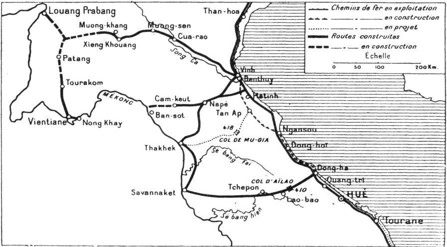
Route 7 of Laos, ເສັ້ນ ທາງ ເລກ 7 ຂອງປະເທດລາວ (ທ. 7) is a provincial road served from east to west in Xiangkhouang province, Laos. It runs from Nong Het in the east to Phoukhoune District in the west. This is where people change connections to go to Luang prabang or Vientiane. History Route 7 (Laos) is built in the early 1905 by a Resident, Mr. ''Sestier''. It started from Vinh to Cua-rao, Vietnam, then to Muong-sen and Tran-Ninh, the former capital of Xieng khouang at the time, in XiangKhouang province, Laos, for a distance of 402 kilometers. During construction, a credit of 300,000 piastres was granted by Mr. Beau, one of the Governor Generals of Indochina at the time. Subsequently, the road was abandoned due to costly maintenance and upkeep. Afterwards, in 1911, it was taken over by a vigorous administrator-creator, Mr. Barthelemy, government commissioner of the Laotian province of Tran-Ninh (Xiangkhouang Plateau), XiangKh ... [...More Info...] [...Related Items...] OR: [Wikipedia] [Google] [Baidu] |
Laos
Laos (, ''Lāo'' )), officially the Lao People's Democratic Republic ( Lao: ສາທາລະນະລັດ ປະຊາທິປະໄຕ ປະຊາຊົນລາວ, French: République démocratique populaire lao), is a socialist state and the only landlocked country in Southeast Asia. At the heart of the Indochinese Peninsula, Laos is bordered by Myanmar and China to the northwest, Vietnam to the east, Cambodia to the southeast, and Thailand to the west and southwest. Its capital and largest city is Vientiane. Present-day Laos traces its historic and cultural identity to Lan Xang, which existed from the 14th century to the 18th century as one of the largest kingdoms in Southeast Asia. Because of its central geographical location in Southeast Asia, the kingdom became a hub for overland trade and became wealthy economically and culturally. After a period of internal conflict, Lan Xang broke into three separate kingdoms: Luang Phrabang, Vientiane and Champasak. In ... [...More Info...] [...Related Items...] OR: [Wikipedia] [Google] [Baidu] |
Plain Of Jars
The Plain of Jars ( Lao: ທົ່ງໄຫຫິນ ''Thong Hai Hin'', ) is a megalithic archaeological landscape in Laos. It consists of thousands of stone jars scattered around the upland valleys and the lower foothills of the central plain of the Xiangkhoang Plateau. The jars are arranged in clusters ranging in number from one to several hundred. The Xiangkhoang Plateau is at the northern end of the Annamese Cordillera, the principal mountain range of Indochina. French researcher Madeleine Colani concluded in 1930 that the jars were associated with burial practices. Excavation by Lao and Japanese archaeologists in the intervening years has supported this interpretation with the discovery of human remains, burial goods and ceramics around the jars. Researchers (using optically stimulated luminescence) determined that the jars were put in place as early as 1240 to 660 BC. The jars at Site 1 (using detrital zircon geochronology) were determined to have been transported to their ... [...More Info...] [...Related Items...] OR: [Wikipedia] [Google] [Baidu] |
UNESCO
The United Nations Educational, Scientific and Cultural Organization is a specialized agency of the United Nations (UN) aimed at promoting world peace and security through international cooperation in education, arts, sciences and culture. It has 193 member states and 12 associate members, as well as partners in the non-governmental, intergovernmental and private sector. Headquartered at the World Heritage Centre in Paris, France, UNESCO has 53 regional field offices and 199 national commissions that facilitate its global mandate. UNESCO was founded in 1945 as the successor to the League of Nations's International Committee on Intellectual Cooperation.English summary). Its constitution establishes the agency's goals, governing structure, and operating framework. UNESCO's founding mission, which was shaped by the Second World War, is to advance peace, sustainable development and human rights by facilitating collaboration and dialogue among nations. It pursues this objective t ... [...More Info...] [...Related Items...] OR: [Wikipedia] [Google] [Baidu] |
Paksan
Pakxan (''Paksan'' or ''Muang Pakxan'') ( Lao ປາກຊັນ) (french: Paksane) is a district and a town in Bolikhamsai Province, in western Laos. It is the capital of Pakxan District. The Nam Xan River joins the Mekong River at Pakxan on the border with Thailand, opposite Bueng Kan. Pakxan is connected to the south of Laos by Route 13. History Pakxan was founded in the late-19th century. The Pakxan region had experienced insecurity since the invasion by Annam in 1834, followed by invasions by the Siamese, and Siamese sovereignty over Laos in 1836, and especially after 1865 with the invasions of Haws or "red flags", gangs from southern China. These invasions began to reduce the populations of Xieng Khouang and Bolikhamsai, but it was the Siamese who completed the depopulation by deporting most of the Phou Eun inhabiting the region.Jean-Louis Archet, ''Formes et résultat des activités du monde rural dans le Koueng Borikhane (Laos)'', mémoire de géographie du sous-d ... [...More Info...] [...Related Items...] OR: [Wikipedia] [Google] [Baidu] |
Phonsavan - Plain Of Jars
Phonsavan ( Lao: ໂພນສະຫວັນ), population 37,507, is the capital of Xiangkhouang Province. Phonsavan was built in the late-1970s and replaced the old Xiangkhouang (today: Muang Khoune) which was destroyed during the Second Indochina War. Phonsavan is known for the nearby Plain of Jars, a UNESCO World Heritage site. The main economic activities in Phonsavan are based on governmental administration, mining by Chinese and Australian companies, tourism, and the work of non-governmental organizations (NGOs) clearing unexploded ordnance (UXO). History While the origin of the Plain of Jars people is unknown, the recorded history of Xiangkhouang is interlinked with the Tai Phuan. The Tai Phuan or Phuan people are a Buddhist Tai-Lao ethnic group that migrated to Laos from southern China and by the 13th century had formed the independent principality Muang Phuan at the Plain of Jars with Xiangkhouang (the contemporary Muang Khoun) as the capital. They prospered from ... [...More Info...] [...Related Items...] OR: [Wikipedia] [Google] [Baidu] |
Houaphanh Province
Houaphanh province ( Laotian: ຫົວພັນ ; Romanization of Lao: ''Houaphan'') is a province in eastern Laos. Its capital is Xam Neua. Houaphanh province covers an area of . The province is bordered by Vietnam to the north, east, and southeast, Xiangkhouang province to the south and southwest, and Luang Prabang province to the west. The terrain is rugged, with dense, forested mountains forming much of the province, particularly on the western side. The main road running through the province is Route 6. The principal rivers are the Nam Ma, which flows from and into Vietnam, passing the village of Ban Muang-Et, and the Nam Sam, on which the towns of Sam Neua and Sam Tai lie. The province is the home to the Viengxay caves, an extensive network of caves used by the Pathet Lao, and the Hintang Archaeological Park, one of the most important pre-historic sites in northern Laos, dotted with standing megaliths. Houaphanh is one of the poorest areas of Laos, but has dramat ... [...More Info...] [...Related Items...] OR: [Wikipedia] [Google] [Baidu] |
Samneua
Xam Neua (ຊຳເໜືອ , sometimes transcribed as ''Sam Neua'' or ''Samneua'', literally 'northern swamp'), is the capital of Houaphanh Province, Laos, in northeast Laos. Demographics Residents are mostly Lao, Vietnamese, and Hmong, with some Tai Dam, Tai Daeng, and Tai Lu. The predominant language is Lao language, Lao with minorities of Vietnamese language, Vietnamese and Hmong language, Hmong. French language, French is spoken by a minority of people as a legacy of the French colonial era. It is taught in schools and used in public works and government. Daily life Xam Neua is in a valley in Houaphanh Province. At 05:45 and 17:45 each day there are public addresses from loudspeakers atop a tower on the school playground, expounding on communist life and philosophy. These addresses are usually accompanied by Lao music. It is said that there is a communist re-education camp in Xam Neua and that it was the Pathet Lao capital during the Laotian Civil War Battle of Lima Si ... [...More Info...] [...Related Items...] OR: [Wikipedia] [Google] [Baidu] |
Vietnam War
The Vietnam War (also known by #Names, other names) was a conflict in Vietnam, Laos, and Cambodia from 1 November 1955 to the fall of Saigon on 30 April 1975. It was the second of the Indochina Wars and was officially fought between North Vietnam and South Vietnam. The north was supported by the Soviet Union, China, and other communist states, while the south was United States in the Vietnam War, supported by the United States and other anti-communism, anti-communist Free World Military Forces, allies. The war is widely considered to be a Cold War-era proxy war. It lasted almost 20 years, with direct U.S. involvement ending in 1973. The conflict also spilled over into neighboring states, exacerbating the Laotian Civil War and the Cambodian Civil War, which ended with all three countries becoming communist states by 1975. After the French 1954 Geneva Conference, military withdrawal from Indochina in 1954 – following their defeat in the First Indochina War – the Viet Minh to ... [...More Info...] [...Related Items...] OR: [Wikipedia] [Google] [Baidu] |
Miao People
The Miao are a group of linguistically-related peoples living in Southern China and Southeast Asia, who are recognized by the government of China as one of the 56 List of ethnic groups in China, official ethnic groups. The Miao live primarily in southern China's mountains, in the provinces of Guizhou, Yunnan, Sichuan, Hubei, Hunan, Guangxi, Guangdong, and Hainan. Some sub-groups of the Miao, most notably the Hmong people, have migrated out of China into Southeast Asia (Myanmar, Northern Vietnam, Laos, and Thailand). Following the History of Laos since 1945#Communist Laos, communist takeover of Laos in 1975, a large group of Hmong refugees resettled in several Western nations, mainly in the United States, France, and Australia. Miao is a Chinese language, Chinese term, while the component groups of people have their own autonyms, such as (with some variant spellings) Hmong people, Hmong, Hmu, Qo Xiong language, Xong (Qo-Xiong), and A-Hmao. These people (except those in Hainan) spea ... [...More Info...] [...Related Items...] OR: [Wikipedia] [Google] [Baidu] |
Hmong People
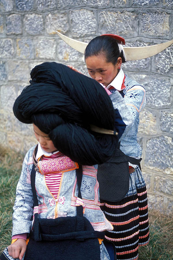
The Hmong people ( RPA: ''Hmoob'', Nyiakeng Puachue: , Pahawh Hmong: , ) are a sub-ethnic group of the Miao people who originated from Central China. The modern Hmongs presently reside mainly in Southwest China (Guizhou, Yunnan, Sichuan, Chongqing, and Guangxi) and countries in Southeast Asia such as Vietnam, Laos, Thailand, and Myanmar. There is also a very large diasporic community in the United States, comprising more than 300,000 Hmong. The Hmong diaspora also has smaller communities in Australia and South America (specifically Argentina and French Guiana, the latter being an overseas region of France). During the First and Second Indo-China Wars, France and the United States intervened in the Lao Civil War by recruiting thousands of Hmong people to fight against forces from North and South Vietnam, which were stationed in Laos in accordance with their mission to support the communist Pathet Lao insurgents. The CIA operation is known as the Secret War. Etymol ... [...More Info...] [...Related Items...] OR: [Wikipedia] [Google] [Baidu] |


