|
Round Island (Detroit River)
Round Island is an island in the Detroit River in southeast Michigan. It is part of Grosse Ile Township, in Wayne County. Its coordinates are , and the United States Geological Survey The United States Geological Survey (USGS), formerly simply known as the Geological Survey, is a scientific agency of the United States government. The scientists of the USGS study the landscape of the United States, its natural resources, ... gave its elevation as in 1980. References Islands of Wayne County, Michigan Islands of the Detroit River River islands of Michigan {{WayneCountyMI-geo-stub ... [...More Info...] [...Related Items...] OR: [Wikipedia] [Google] [Baidu] |
United States Geological Survey
The United States Geological Survey (USGS), formerly simply known as the Geological Survey, is a scientific agency of the United States government. The scientists of the USGS study the landscape of the United States, its natural resources, and the natural hazards that threaten it. The organization's work spans the disciplines of biology, geography, geology, and hydrology. The USGS is a fact-finding research organization with no regulatory responsibility. The agency was founded on March 3, 1879. The USGS is a bureau of the United States Department of the Interior; it is that department's sole scientific agency. The USGS employs approximately 8,670 people and is headquartered in Reston, Virginia. The USGS also has major offices near Lakewood, Colorado, at the Denver Federal Center, and Menlo Park, California. The current motto of the USGS, in use since August 1997, is "science for a changing world". The agency's previous slogan, adopted on the occasion of its hundredt ... [...More Info...] [...Related Items...] OR: [Wikipedia] [Google] [Baidu] |
Michigan
Michigan () is a state in the Great Lakes region of the upper Midwestern United States. With a population of nearly 10.12 million and an area of nearly , Michigan is the 10th-largest state by population, the 11th-largest by area, and the largest by area east of the Mississippi River.''i.e.'', including water that is part of state territory. Georgia is the largest state by land area alone east of the Mississippi and Michigan the second-largest. Its capital is Lansing, and its largest city is Detroit. Metro Detroit is among the nation's most populous and largest metropolitan economies. Its name derives from a gallicized variant of the original Ojibwe word (), meaning "large water" or "large lake". Michigan consists of two peninsulas. The Lower Peninsula resembles the shape of a mitten, and comprises a majority of the state's land area. The Upper Peninsula (often called "the U.P.") is separated from the Lower Peninsula by the Straits of Mackinac, a channel that joins Lak ... [...More Info...] [...Related Items...] OR: [Wikipedia] [Google] [Baidu] |
Wayne County, Michigan
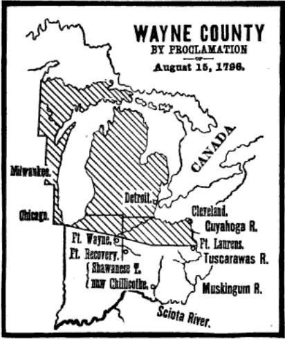
Wayne County is the most populous county in the U.S. state of Michigan. As of 2020, the United States Census placed its population at 1,793,561, making it the 19th-most populous county in the United States. The county seat is Detroit. The county was founded in 1796 and organized in 1815. Wayne County is included in the Detroit-Warren- Dearborn, MI Metropolitan Statistical Area. It is one of several U.S. counties named after Revolutionary War-era general Anthony Wayne. History Wayne County was the sixth county in the Northwest Territory, formed August 15, 1796 from portions of territorial Hamilton County, territorial Knox County and unorganized territory. It was named for the U.S. general "Mad Anthony" Wayne. It originally encompassed the entire area of the Lower Peninsula of Michigan, most of the Upper Peninsula, as well as smaller sections that are now part of northern Ohio, Indiana, Illinois and Wisconsin. By proclamation of the Territorial Secretary and Acting Govern ... [...More Info...] [...Related Items...] OR: [Wikipedia] [Google] [Baidu] |
Detroit River
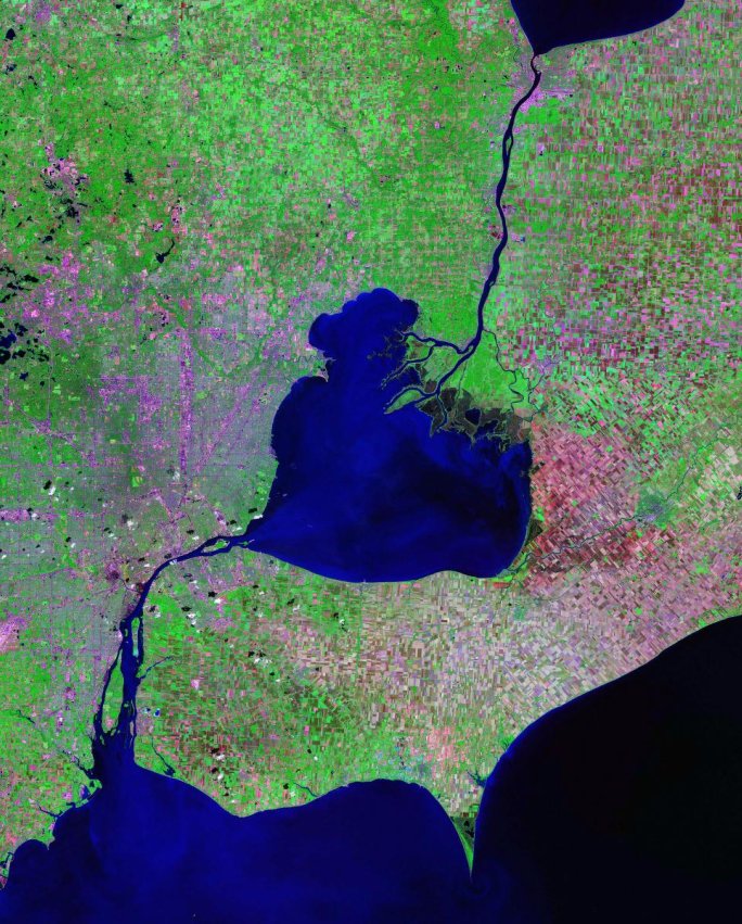
The Detroit River flows west and south for from Lake St. Clair to Lake Erie as a strait in the Great Lakes system. The river divides the metropolitan areas of Detroit, Michigan, and Windsor, Ontario, Windsor, Ontario—an area collectively referred to as Detroit–Windsor—and forms part of the Canada–United States border, border between Canada and the United States. The Ambassador Bridge, the Detroit–Windsor Tunnel, and the Michigan Central Railway Tunnel connect the cities. The river's English name comes from the French language, French (translated as "River of the Strait"). The Detroit River has served an important role in the history of Detroit and Windsor, and is one of the world's busiest waterways. It is an important transportation route connecting Lake Michigan, Lake Huron, and Lake Superior to Lake Erie and eventually to Lake Ontario, the Saint Lawrence Seaway, St. Lawrence Seaway and the Erie Canal. When Detroit underwent rapid industrialization at the turn of th ... [...More Info...] [...Related Items...] OR: [Wikipedia] [Google] [Baidu] |
Southeast Michigan
Southeast Michigan, also called southeastern Michigan, is a region in the Lower Peninsula of Michigan that is home to a majority of the state's businesses and industries as well as slightly over half of the state's population, most of whom are concentrated in Metro Detroit. Geography It is bordered in the northeast by Lake St. Clair, to the south-east Lake Erie, and the Detroit River which connects these two lakes. Principal cities *Detroit, the state's largest city (and the nation's eighteenth-largest) and the county seat of Wayne County. * Mount Clemens, the county seat of Macomb County. *Pontiac, the county seat of Oakland County. Other important cities within the core counties of Oakland, Macomb, and Wayne *Birmingham * Dearborn *Livonia * Novi *Romulus, home to Detroit Metro Airport *Royal Oak * Southfield *Sterling Heights, the fourth-largest city (by population) in Michigan. *Troy *Warren, third-largest city (by population) in Michigan, location of General Motors Tec ... [...More Info...] [...Related Items...] OR: [Wikipedia] [Google] [Baidu] |
Grosse Ile Township
Grosse Ile Township is a civil township of Wayne County in the U.S. state of Michigan. The population was 10,777 at the 2020 census. The township encompasses several islands in the Detroit River, of which the largest is named as Grosse Ile. Named by French explorers in 1679, ''Grosse Île'' means "Big Island". Later taken under British rule after 1763, the island was not settled by European Americans until after the United States achieved independence in the American Revolutionary War. Grosse Ile Township was organized in 1914 after it split away from Monguagon Township. Geography According to the United States Census Bureau, the township has a total area of , of which is land and (50.72%) is water. Grosse Ile is the largest island on the Detroit River. The township of Grosse Ile is composed of twelve islands, although the community is most often identified with the main island (which residents simply refer to as "The Island"). Grosse Ile's main island is technically c ... [...More Info...] [...Related Items...] OR: [Wikipedia] [Google] [Baidu] |
Islands Of Wayne County, Michigan
An island (or isle) is an isolated piece of habitat that is surrounded by a dramatically different habitat, such as water. Very small islands such as emergent land features on atolls can be called islets, skerries, cays or keys. An island in a river or a lake island may be called an eyot or ait, and a small island off the coast may be called a holm. Sedimentary islands in the Ganges delta are called chars. A grouping of geographically or geologically related islands, such as the Philippines, is referred to as an archipelago. There are two main types of islands in the sea: continental and oceanic. There are also artificial islands, which are man-made. Etymology The word ''island'' derives from Middle English ''iland'', from Old English ''igland'' (from ''ig'' or ''ieg'', similarly meaning 'island' when used independently, and -land carrying its contemporary meaning; cf. Dutch ''eiland'' ("island"), German ''Eiland'' ("small island")). However, the spelling of the word w ... [...More Info...] [...Related Items...] OR: [Wikipedia] [Google] [Baidu] |
Islands Of The Detroit River
The following is a description of islands in the Detroit River. The Detroit River is a major waterway in the Great Lakes system, and it flows for from Lake St. Clair south to Lake Erie. The river serves as a major shipping channel, jointly controlled by the United States and Canada, and it is a major component of the Canada–United States border. The majority of islands are on the American side of the river, which are all within Wayne County in Michigan. The Canadian islands are part of Essex County in Ontario. There are no islands in the Detroit River that are divided by the international border, as Michigan and Ontario share no land borders at any point. Most of the islands are very small and uninhabited, and many of these islands around the southern portion of the river serve as nature reserves as part of the Detroit River International Wildlife Refuge. The largest and most populated island is Grosse Ile, and many islands are part of Grosse Ile Township. Several is ... [...More Info...] [...Related Items...] OR: [Wikipedia] [Google] [Baidu] |


