|
Richard L. Lawson
Richard Laverne Lawson (December 19, 1929 – January 20, 2020) was a general and deputy commander in chief, Headquarters United States European Command, Stuttgart-Vaihingen, Germany. Biography Early life Lawson was born in Fairfield, Iowa, in 1929, where he graduated from high school. He attended the University of Iowa. While at Parsons College, Lawson enlisted in the Iowa Army National Guard and was later called to active duty as the 133rd Infantry Regiment's sergeant major at Fort Riley, Kansas. He was commissioned a second lieutenant in November 1951 and assigned as adjutant for the 133rd Aircraft Control and Warning Squadron, Alexandria, Louisiana. He graduated from Parsons in 1951 with a bachelor of science degree. In May 1952, Lawson transferred to the regular Air Force entered pilot training at Columbus Air Force Base, Mississippi, and completed training at Reese Air Force Base, Texas in July 1953. He was then assigned to the 69th Bombardment Squadron at Loring Air ... [...More Info...] [...Related Items...] OR: [Wikipedia] [Google] [Baidu] |
Fairfield, Iowa
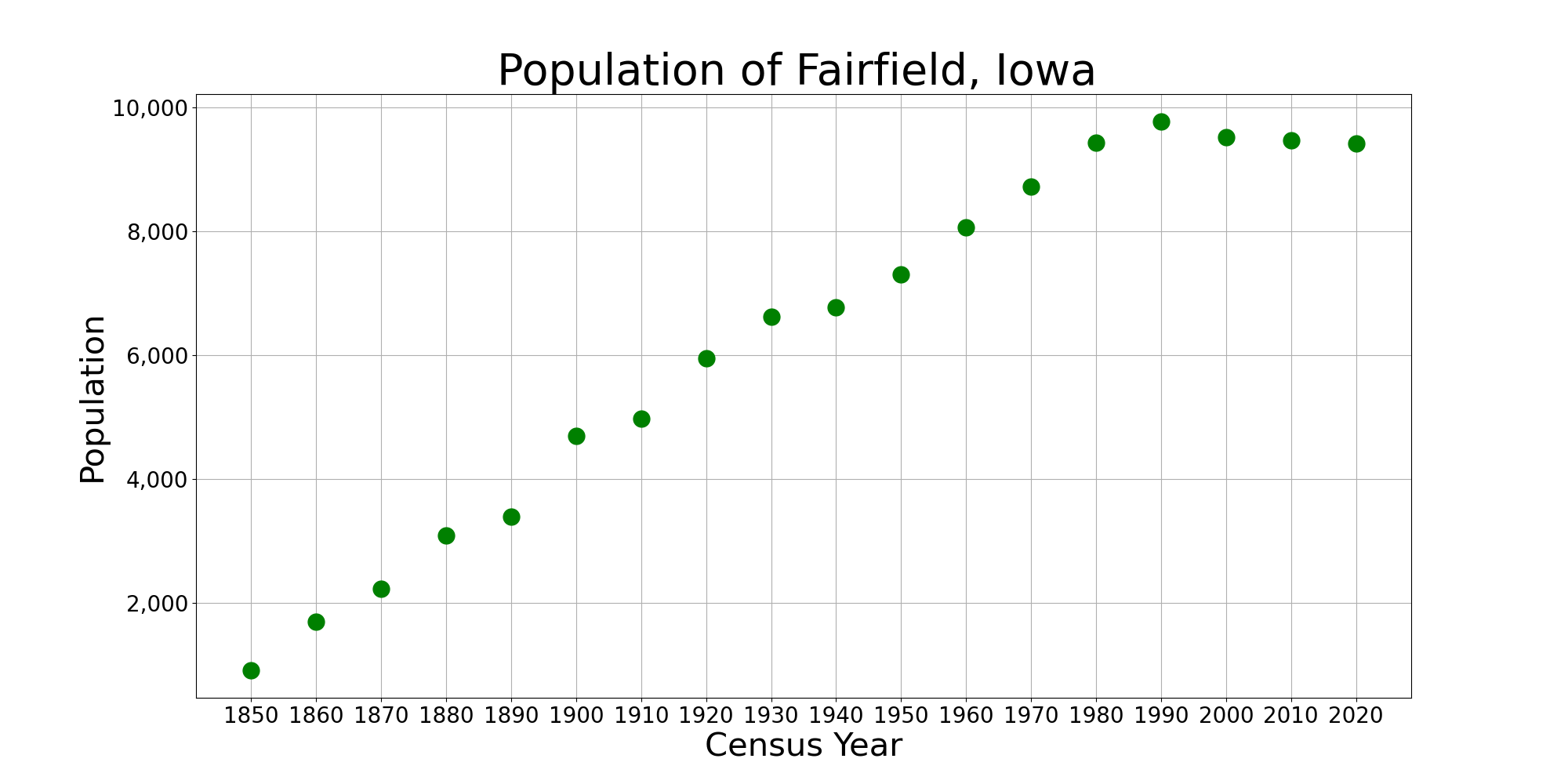
Fairfield is a city in, and the county seat of, Jefferson County, Iowa. It has a population of 9,416 people, according to the 2020 census. The median family income is $46,138, with 10% of families below the poverty line. The city is typical of the American Midwest, being situated amidst rolling farmlands filled with corn, soybean, cattle, and hogs. It became the county seat in 1839 with 110 residents and grew to 650 by 1847. Its library was established in 1853, and it held its first fair in 1854. Early architecture in Fairfield includes work by George Franklin Barber and Barry Byrne, who trained under Frank Lloyd Wright. History The area now known as Jefferson County was first settled in 1836, and became Jefferson County in 1839, with the new community of Fairfield as the county seat. The name was suggested by Nancy Bonnifield, one of the settlers, because it aptly described the fair fields of the area. But also author Susan Welty suggests it was a play of words on her own na ... [...More Info...] [...Related Items...] OR: [Wikipedia] [Google] [Baidu] |
Convair B-36 Peacemaker
The Convair B-36 "Peacemaker" is a strategic bomber that was built by Convair and operated by the United States Air Force (USAF) from 1949 to 1959. The B-36 is the largest mass-produced piston-engined aircraft ever built. It had the longest wingspan of any combat aircraft ever built, at . The B-36 was the first bomber capable of delivering any of the nuclear weapons in the U.S. arsenal from inside its four bomb bays without aircraft modifications. With a range of and a maximum payload of , the B-36 was capable of intercontinental flight without refuelling. Entering service in 1948, the B-36 was the primary nuclear weapons delivery vehicle of Strategic Air Command (SAC) until it was replaced by the jet-powered Boeing B-52 Stratofortress beginning in 1955. All but four aircraft have been scrapped. Development The genesis of the B-36 can be traced to early 1941, prior to the entry of the United States into World War II. At the time, the threat existed that Britain might fall t ... [...More Info...] [...Related Items...] OR: [Wikipedia] [Google] [Baidu] |
Maine
Maine () is a state in the New England and Northeastern regions of the United States. It borders New Hampshire to the west, the Gulf of Maine to the southeast, and the Canadian provinces of New Brunswick and Quebec to the northeast and northwest, respectively. The largest state by total area in New England, Maine is the 12th-smallest by area, the 9th-least populous, the 13th-least densely populated, and the most rural of the 50 U.S. states. It is also the northeasternmost among the contiguous United States, the northernmost state east of the Great Lakes, the only state whose name consists of a single syllable, and the only state to border exactly one other U.S. state. Approximately half the area of Maine lies on each side of the 45th parallel north in latitude. The most populous city in Maine is Portland, while its capital is Augusta. Maine has traditionally been known for its jagged, rocky Atlantic Ocean and bayshore coastlines; smoothly contoured mountains; heavily f ... [...More Info...] [...Related Items...] OR: [Wikipedia] [Google] [Baidu] |
Loring Air Force Base
Loring Air Force Base was a United States Air Force installation in northeastern Maine, near Limestone and Caribou in Aroostook County. It was one of the largest bases of the U.S. Air Force's Strategic Air Command during its existence, and was transferred to the newly created Air Combat Command in 1992. The base's origins began in 1947 with an order for construction of an airfield by the New England Division of the United States Army Corps of Engineers. The chosen site, in northeastern Maine within both Limestone Township and Caswell Plantation, was the closest point in the continental U.S. to Europe, providing high strategic value during the Cold War. The base was originally named Limestone Army Air Field, and was renamed Limestone Air Force Base following the establishment of the Air Force in 1947. It was named in 1954 for Major Charles J. Loring, Jr., USAF, a Medal of Honor recipient during the Korean War. From 1951 to 1962, it was co-located next to Caribou Air Force Statio ... [...More Info...] [...Related Items...] OR: [Wikipedia] [Google] [Baidu] |
Texas
Texas (, ; Spanish language, Spanish: ''Texas'', ''Tejas'') is a state in the South Central United States, South Central region of the United States. At 268,596 square miles (695,662 km2), and with more than 29.1 million residents in 2020, it is the second-largest U.S. state by both List of U.S. states and territories by area, area (after Alaska) and List of U.S. states and territories by population, population (after California). Texas shares borders with the states of Louisiana to the east, Arkansas to the northeast, Oklahoma to the north, New Mexico to the west, and the Mexico, Mexican States of Mexico, states of Chihuahua (state), Chihuahua, Coahuila, Nuevo León, and Tamaulipas to the south and southwest; and has a coastline with the Gulf of Mexico to the southeast. Houston is the List of cities in Texas by population, most populous city in Texas and the List of United States cities by population, fourth-largest in the U.S., while San Antonio is the second most pop ... [...More Info...] [...Related Items...] OR: [Wikipedia] [Google] [Baidu] |
Reese Air Force Base
Reese Technology Center is a research and business park located on the grounds of former Reese Air Force Base in western Lubbock at the unincorporated community of Reese Center. History Reese Technology Center began as the Lubbock Army Air Corps Advanced Flying School in 1942. It was renamed Lubbock Army Flying School in 1943 and then Lubbock Army Airfield later that same year. In 1949, it was renamed Reese Air Force Base in honor of a local West Texas pilot, Augustus F. Reese, Jr., who was killed in a bombing raid over Italy during World War II. Over the years, many milestones were accomplished at Reese Air Force Base, including a special pilot training program, the first flight simulator used in a training program, and a joint pilot training program with the Navy. More than 25,000 pilots, who fought in every conflict since World War II, were trained at Reese. In 1995, word reached the Lubbock community that Reese Air Force Base was on the Pentagon’s list for base closures. ... [...More Info...] [...Related Items...] OR: [Wikipedia] [Google] [Baidu] |
Mississippi
Mississippi () is a state in the Southeastern region of the United States, bordered to the north by Tennessee; to the east by Alabama; to the south by the Gulf of Mexico; to the southwest by Louisiana; and to the northwest by Arkansas. Mississippi's western boundary is largely defined by the Mississippi River. Mississippi is the 32nd largest and 35th-most populous of the 50 U.S. states and has the lowest per-capita income in the United States. Jackson is both the state's capital and largest city. Greater Jackson is the state's most populous metropolitan area, with a population of 591,978 in 2020. On December 10, 1817, Mississippi became the 20th state admitted to the Union. By 1860, Mississippi was the nation's top cotton-producing state and slaves accounted for 55% of the state population. Mississippi declared its secession from the Union on January 9, 1861, and was one of the seven original Confederate States, which constituted the largest slaveholding states in t ... [...More Info...] [...Related Items...] OR: [Wikipedia] [Google] [Baidu] |
Columbus Air Force Base
Columbus Air Force Base is a United States Air Force base located in Columbus, Mississippi. The host unit at Columbus AFB is the 14th Flying Training Wing (14 FTW), which is a part of Air Education and Training Command (AETC). The residential portion of the base is a census-designated place, with a population of 1,604 at the 2020 census. Base history Columbus Air Force Base (AFB) was established in 1941, after the US War Department authorized a pilot training base in Columbus, Mississippi. It was originally named Kaye Field, after World War I flying ace Samuel Kaye Jr., but confusion with nearby Key Field in Meridian, Mississippi led to it being renamed as Columbus Army Flying School. The base was deactivated after the end of World War II, but was reactivated four years later with the beginning of the Korean War. In 1955, Columbus AFB was transferred to Strategic Air Command (SAC) and was occupied by the 4228th Strategic Wing, which later became the 454th Bombardment Wi ... [...More Info...] [...Related Items...] OR: [Wikipedia] [Google] [Baidu] |
Alexandria, Louisiana
Alexandria is the ninth-largest city in the state of Louisiana and is the parish seat of Rapides Parish, Louisiana, United States. It lies on the south bank of the Red River in almost the exact geographic center of the state. It is the principal city of the Alexandria metropolitan area (population 153,922) which encompasses all of Rapides and Grant parishes. Its neighboring city is Pineville. In 2010, the population was 47,723, an increase of 3 percent from the 2000 census. History Located along the Red River, the city of Alexandria was originally home to a community which supported activities of the adjacent French trader outpost of ''Post du Rapides''. The area developed as an assemblage of traders, Caddo people, and merchants in the agricultural lands bordering the mostly unsettled areas to the north and providing a link from the south to the El Camino Real and then larger settlement of Natchitoches, the oldest permanent settlement in the Louisiana Purchase. Ale ... [...More Info...] [...Related Items...] OR: [Wikipedia] [Google] [Baidu] |


