|
Rannes
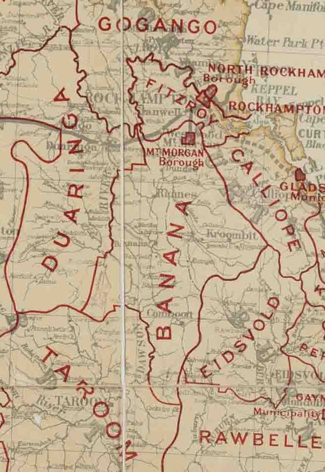
Rannes is a rural town in the west of the locality of Goovigen in the Shire of Banana, Queensland, Australia. Geography Rannes is in Central Queensland between Wowan and Banana on the Leichhardt Highway and the Don River. History Rannes was established as a pastoral sheep station property in April 1853 by Scottish brothers James, Norman and Charles Leith Hay. The brothers were the offspring of Peninsula War veteran Andrew Leith Hay and the grandsons of General Alexander Leith Hay of Leith Hall. They were the first Europeans to occupy the region and at that time Rannes was the northern-most outpost of British colonisation in Eastern Australia. The brothers named the property Rannes after a Leith Hay family manor house located near Buckie in Scotland. On 11 May 1853, James Leith Hay sent a letter to Lieutenant John Murray, reporting that two of his shepherds had been murdered by Aborigine men and requested the services of the Native Police. On 16 May, Murray and a ... [...More Info...] [...Related Items...] OR: [Wikipedia] [Google] [Baidu] |
Callide Valley Railway Line
The Callide Valley railway line ran from Rannes to Lawgi in Queensland, Australia. The Callide Valley lies to the south-west of Rockhampton in Central Queensland. History There were grand plans to link Monto by railway with the south, east and north. Links with Maryborough to the south and Gladstone to the east materialised but the northern link terminated at Lawgi some 70 kilometres away. Rannes was already linked by rail to Rockhampton by the Dawson Valley railway line via Mount Morgan and a branch line from Rannes to Lawgi provided access to the rich Callide Valley and justified its construction. Opening The first stage commenced from Rannes, heading south-east to Callide (originally called Callidi) and opened on 3 May 1924. Stops en route were Jooro, Goovigen, Jambin and Argoon. A mixed train ran twice a week from Baralaba, west of Rannes on the Dawson Valley branch, to Callide and connected at Rannes with a service northeast to Rockhampton. A 22 kilometre ... [...More Info...] [...Related Items...] OR: [Wikipedia] [Google] [Baidu] |
Goovigen
Goovigen is a rural town and locality in the Shire of Banana, Queensland, Australia. In the , the locality of Goovigen had a population of 215 people. A second town, Rannes (), is also within the locality of Goovigen, near its western boundary. Koorngoo is a neighbourhood () within the locality, just west of centre, based around a former railway station. Geography The town is towards the south-east of the locality, approximately north west of the state capital, Brisbane. The Burnett Highway enters the locality from the north ( Dixalea) and exits to the east ( Jambin) without coming close to either of the two towns. The Leichhardt Highway enters the locality from the south-west ( Kokotunga / Woolein) and then. forms the south-west boundary of the locality and passes immediately west of the town of Rannes before exiting to the west ( Dumpy Creek). The now-closed Callide Valley railway line ran through the locality which was served by a number of now-abandoned railway stati ... [...More Info...] [...Related Items...] OR: [Wikipedia] [Google] [Baidu] |
Dawson Valley (Theodore) Railway Line
The Dawson Valley Branch Railway was a railway line in Central Queensland, Australia. It branched from the Central Western railway line at Kabra in the Rockhampton Region and went via Mount Morgan to Theodore in the Shire of Banana. It opened in a series of sections between 1898 and 1927, and featured a rack railway section, one of only 3 such systems in Australia. History Gold was discovered in the Mount Morgan region of Central Queensland in 1882. The Mount Morgan Gold Mining Company was authorised by government in 1890 to build a railway link to Rockhampton but it did not proceed. Revised plans were approved by Queensland Parliament in December 1896 for a government-built line. The 1890 proposal had involved a conventional line with 1 in 50 (2%) grades and a tunnel at the crest of the Razorback Range. Its cost and the risk of the mine having a short life deterred both the government and the company. By adopting a rack railway section the cost of building the line ... [...More Info...] [...Related Items...] OR: [Wikipedia] [Google] [Baidu] |
Shire Of Banana
The Shire of Banana is a local government area located in the Capricorn region of Queensland, Australia, inland from the regional city of Gladstone. The shire was named after the first township in the region (Banana), which in turn was named for the burial site of a huge dun coloured bullock named 'Banana'. The council sits in the town of Biloela, which is the largest town in the Shire. Major industries in the shire include coal mining, beef production, power generation, dryland cropping and irrigation cropping such as lucerne and cotton. History Banana Division was created on 11 November 1879 as one of 74 divisions around Queensland under the ''Divisional Boards Act 1879'' with a population of 2155. The name ''Banana'' does not relate to the fruit, but rather the area was named after a dun-coloured bullock called ''Banana''. On 20 April 1881 part of Banana Division was separated to create Duaringa Division. With the passage of the ''Local Authorities Act 1902'', Bana ... [...More Info...] [...Related Items...] OR: [Wikipedia] [Google] [Baidu] |
Banana, Queensland
Banana is a rural town and locality in the Shire of Banana, Queensland, Australia. In the , the locality of Banana had a population of 356 people. Geography Banana is located at the intersection of the Dawson and Leichhardt highways, west of the shire's administrative centre, Biloela. History '' Gangalu (Gangulu, Kangulu, Kanolu, Kaangooloo, Khangulu)'' is an Australian Aboriginal language spoken on Gangula country. The Gangula language region includes the towns of Clermont and Springsure extending south towards the Dawson River. In 1853, James, Norman and Charles Leith-Hay established the Rannes pastoral lease and Banana was an outstation of this property. Banana became its own squatting leasehold sheep station property in 1855 with the Leith-Hays and Thomas Holt holding the licence. In 1855 a group of Aboriginal people attacked Banana Station wounding five people and stealing 3,000 sheep. In April 1858, a number of Aboriginal people in an unprovoked attack, murdered 4 me ... [...More Info...] [...Related Items...] OR: [Wikipedia] [Google] [Baidu] |
Wowan, Queensland
Wowan is a rural town and locality in the Shire of Banana, Queensland, Australia. In the , the locality of Wowan had a population of 216 people. The town of Deeford is also within the locality. Geography The '' Dee River'' forms part of the eastern boundary. Both towns are located in the north-east of the locality with Deeford at near a crossing point of the Dee River. There are also a number of neighbourhoods within the location: * Buneru () * Cooneel () * Muruguran () The Leichhardt Highway runs through from north to south through the localityl, passing through the town of Wowan. History Wowan takes its name from the Wowan railway station, which in turn was named from the Aboriginal word for Australian brush-turkey. Deeford was originally known as Dundee, but was renamed Deeford on 6 November 1913 by the Queensland Surveyor-General. Dundee Provisional School opened on 1 June 1900. It closed in 1904 but reopened in 1905. On 1 January 1909 it became Dundee State Schoo ... [...More Info...] [...Related Items...] OR: [Wikipedia] [Google] [Baidu] |
Biloela
Biloela ( ) is a rural town and locality in Shire of Banana, Central Queensland, Australia. It is situated inland from the port city of Gladstone at the junction of the Burnett and Dawson highways. Biloela is the administrative centre of Banana Shire, which has an area of . In the , the locality of Biloela had a population of 5,692 people. History Aboriginal history The town was established on what is Gangulu tribal lands. '' Gangalu (Gangulu, Kangulu, Kanolu, Kaangooloo, Khangulu)'' is an Australian Aboriginal language spoken on Gangula country. The Gangula language region includes the towns of Clermont and Springsure extending south towards the Dawson River. There was a ceremonial bora ground behind what is now the main street of Bileola and the local entombment custom was to place the skeletal remains of their dead in hollowed out burial trees which were specially marked with red ochre. Dingoes were used in the process of mustering and killing of kangaroo and emu for food ... [...More Info...] [...Related Items...] OR: [Wikipedia] [Google] [Baidu] |
Native Police
Australian native police units, consisting of Aboriginal troopers under the command (usually) of at least one white officer, existed in various forms in all Australian mainland colonies during the nineteenth and, in some cases, into the twentieth centuries. The Native Mounted Police utilised horses as their transportation mode in the days before motor cars, and patrolled huge geographic areas. The introduction of a Police presence helped provide law & order to areas which were already struggling with crime issues. From established base camps they patrolled vast areas to investigate law breaches, including alleged murders. Often armed with rifles, carbines and swords, they sometimes also escorted surveying groups, pastoralists and prospectors through country considered to be dangerous. The Aboriginal men within the Native Police were routinely recruited from areas that were very distant from the locations in which they were deployed. As the troopers were Aboriginal, this benefit ... [...More Info...] [...Related Items...] OR: [Wikipedia] [Google] [Baidu] |
John Murray (native Police Officer)
John Murray (23 February 1827 – 30 July 1876) was a Scottish officer in the Australian native police in the British colonies of New South Wales and Queensland. He was an integral part of this paramilitary force for nearly twenty years, supporting European colonisation in south-eastern, central and northern Queensland. He also had an important role in recruiting troopers for the Native Police from the Riverina District in New South Wales. Early life John Murray was born on 23 February 1827 at his family's ''Georgefield'' estate near Langholm in southern Scotland. His grandfather was Lieutenant Colonel Matthew Murray of the East India Company who married a Malayali woman named Contity from Kerala while in India. The offspring of this marriage, including John's father James Murray, were collectively dubbed the "Black Murrays" on account of their darker skin colour. In 1843, at the age of sixteen, John Murray arrived in New South Wales with his parents and siblings. After initi ... [...More Info...] [...Related Items...] OR: [Wikipedia] [Google] [Baidu] |
Andrew Leith Hay
Sir Andrew Leith Hay of Rannes (17 February 1785 – 13 October 1862) was a Scottish soldier, Whig politician and writer on architecture. Biography Andrew Leith Hay was the eldest son of General Alexander Leith Hay of Rannes and Mary Forbes of Ballogie (died 1824), and was born at Aberdeen on 17 February 1785. He entered the army as an Ensign (rank), ensign in the 72nd Regiment of Foot, 72nd Foot on 8 January 1806, went to the Peninsula in 1808 as aide-de-camp to his uncle, General Sir James Leith (British Army officer), James Leith, and served through the war until 1814. He was much employed in gaining intelligence, and was present at many of the actions from Battle of Corunna, Corunna to the Siege of San Sebastian, storming of San Sebastian. Wherever he went he made sketches, and in 1831 worked up these materials into two volumes, entitled ''A Narrative of the Peninsula War''. On General Leith being appointed to the governorship of Barbados, Barbadoes in 1816, his nephew acco ... [...More Info...] [...Related Items...] OR: [Wikipedia] [Google] [Baidu] |
Alexander Leith Hay
thumb General Alexander Leith-Hay 'formerly'' Alexander Leith(1758 – 16 May 1838), was a British Army officer. Life Hay was born in Aberdeen on 21 December 1758, the second son of John Leith (1731–1763) of Leith Hall, Aberdeenshire and his wife, Harriet (d. 1780), daughter and heir of Alexander Steuart of Auchluncart. He was appointed a lieutenant in the 7th Dragoons immediately on his birth, captain 1768, and colonel in the army 1794. Upon the death of Andrew Hay in 1789 he inherited the estate of Rannes, Aberdeenshire, and assumed the additional title Hay of Rannes, being descended from that family through his paternal grandmother. On 1 October in the same year he was gazetted colonel of a regiment raised by himself and called by his name. He was promoted to be major-general 1796, lieutenant-general 1803 and full general 1838. He was deputy lieutenant and justice of the peace for the county of Aberdeenshire. Family He married in 1784 Mary, daughter of Charles Forbes of ... [...More Info...] [...Related Items...] OR: [Wikipedia] [Google] [Baidu] |
Buckie
Buckie ( gd, Bucaidh) is a burgh town (defined as such in 1888) on the Moray Firth coast of Scotland. Historically in Banffshire, Buckie was the largest town in the county until the administrative area was abolished in 1975. The town is the third largest in the Moray council area after Elgin and Forres and within the definitions of statistics published by the General Register Office for Scotland was ranked at number 75 in the list of population estimates for settlements in Scotland mid-year 2006. Buckie is virtually equidistant to Banff to the east and Elgin to the west, with both approximately distant whilst Keith lies to the south by road. Etymology The origin of the name of the town is not entirely clear. Although the folk etymology is that Buckie is named after a seashell (genus ''buccinum'') the reality is that the shared marine background is a coincidence. The name Buckie would not have originally identified a place immediately adjacent to the sea, so alternative ... [...More Info...] [...Related Items...] OR: [Wikipedia] [Google] [Baidu] |


