|
Rani Kot
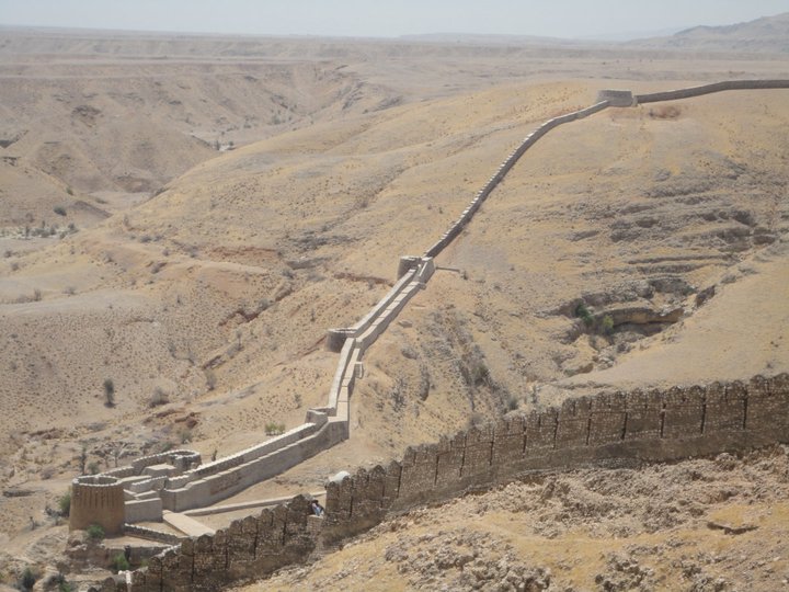
Ranikot Fort ( sd, راڻي ڪوٽ) (also known as Rannikot) is a historical Talpur fort near Sann, Jamshoro District, Sindh. in Pakistan .Ranikot Fort is also known as The Great Wall of Sindh and is believed to be the world's largest fort, with a circumference of approximately . The fort's ramparts have been compared to the Great Wall of China. The site was nominated in 1993 by the Pakistan National Commission for UNESCO world heritage status, and has since been on the tentative list of UNESCO World Heritage Sites. The fort is listed as a historical site under the Antiquities Act, 1975 and its subsequent amendments, and is provided protection. Location Ranikot Fort is to the north of Hyderabad on the indus highway (N55). There is also an easy access of about an hour's journey from Karachi to Sann on the Indus Highway. A diversion road, starting a little distance away from Sann, the nearest town, leads to the fort along a rugged road and reaches the eastern gate of the fort ... [...More Info...] [...Related Items...] OR: [Wikipedia] [Google] [Baidu] |
List Of Forts In Pakistan
The following is a partial list of forts and castles in Pakistan: See also * Tourism in Pakistan * List of UNESCO World Heritage Sites in Pakistan * List of museums in Pakistan * Lahore Fort * Rohtas Fort * Noor Mahal * Derawar Fort References External links Forts of Pakistan by Shaikh Muhammad Ali {{Castles in Pakistan Castles in Pakistan, * Forts in Pakistan, * Lists of forts, Pakistan Pakistan military-related lists, Forts Lists of tourist attractions in Pakistan, Forts ... [...More Info...] [...Related Items...] OR: [Wikipedia] [Google] [Baidu] |
Jamshoro District
Jamshoro District ( sd, ضلعو ڄام شورو, ur, ), is a district of Sindh province, Pakistan. Jamshoro city is the capital while Kotri is the largest city of the Jamshoro District. The district borders Dadu district to the north. To the east, the Indus separates it from Nawab Shah, Matyari and Hyderabad districts. Thatta district lies to the south, and Karachi district to the south west. To the west, the Kheerthar Range separates it from the Sindh and Lasbela district of Baluchistan. Jamshoro District was split from Dadu District in 14th December 2004 It is situated on the west bank of River Indus. Geography The total geographical area of the district is 11,260 square kilometres. It is about 220 kilometers from north to south and about 100 kilometres wide from east to west. A 2 to 6 kilometres wide belt of the west bank of River Indus is cultivated and irrigated and the remaining land of the district is either hilly or cultivated. Agriculture is the main source of in ... [...More Info...] [...Related Items...] OR: [Wikipedia] [Google] [Baidu] |
Archaeologists
Archaeology or archeology is the scientific study of human activity through the recovery and analysis of material culture. The archaeological record consists of artifacts, architecture, biofacts or ecofacts, sites, and cultural landscapes. Archaeology can be considered both a social science and a branch of the humanities. It is usually considered an independent academic discipline, but may also be classified as part of anthropology (in North America – the four-field approach), history or geography. Archaeologists study human prehistory and history, from the development of the first stone tools at Lomekwi in East Africa 3.3 million years ago up until recent decades. Archaeology is distinct from palaeontology, which is the study of fossil remains. Archaeology is particularly important for learning about prehistoric societies, for which, by definition, there are no written records. Prehistory includes over 99% of the human past, from the Paleolithic until the adve ... [...More Info...] [...Related Items...] OR: [Wikipedia] [Google] [Baidu] |
Hyderabad District, Pakistan
Hyderabad District ( sd, ضلعو حيدرآباد ur, ), is a district of Sindh, Pakistan. Its capital is the city of Hyderabad. The district is the second most urbanized in Sindh, after Karachi, with 80% of its residents live in urban areas. History The East India Company occupied Sindh in 1843; They formed three districts in Sindh administratively: Hyderabad, Karachi and Shikarpur (now Sukkur district). In 1982, the largest area of the district in eastern side bifurcated to create a new district Thar and Parkar district with the headquarters Umerkot. In 1907, create a new taluka named Nasrat from Sakrand and Shahdadpur taluka. In 1912, the northern side of the district separated to form Nawabshah district. In 1975, Southern side also separated to form Badin district. After 1998 census, two new talukas created in the district named; Hyderabad city and Latifabad talukas. After 2002 elections, a new taluka created in the district named Qasimabad from Hyderabad City ta ... [...More Info...] [...Related Items...] OR: [Wikipedia] [Google] [Baidu] |
Forts In Sindh
A fortification is a military construction or building designed for the defense of territories in warfare, and is also used to establish rule in a region during peacetime. The term is derived from Latin ''fortis'' ("strong") and ''facere'' ("to make"). From very early history to modern times, defensive walls have often been necessary for cities to survive in an ever-changing world of invasion and conquest. Some settlements in the Indus Valley civilization were the first small cities to be fortified. In ancient Greece, large stone walls had been built in Mycenaean Greece, such as the ancient site of Mycenae (famous for the huge stone blocks of its 'cyclopean' walls). A Greek '' phrourion'' was a fortified collection of buildings used as a military garrison, and is the equivalent of the Roman castellum or English fortress. These constructions mainly served the purpose of a watch tower, to guard certain roads, passes, and borders. Though smaller than a real fortress, they ... [...More Info...] [...Related Items...] OR: [Wikipedia] [Google] [Baidu] |
List Of Museums In Pakistan
This is a list of museums, galleries, and related building structures in Pakistan. Museums and galleries Archaeological and historical museums * Harappa Museum, Harappa * Bahawalpur Museum, Bahawalpur * Bannu Museum, Bannu * Chitral Museum * City Museum, Gorkhatri, Peshawar * Dir Museum, Chakdara * Hund Museum, Swabi * Kasur Museum, Kasur * Kalasha Dur Museum, Chitral * Lahore Museum, Lahore ... [...More Info...] [...Related Items...] OR: [Wikipedia] [Google] [Baidu] |
List Of UNESCO World Heritage Sites In Pakistan
The United Nations Educational, Scientific and Cultural Organization (UNESCO) World Heritage Sites are places of importance to cultural or natural heritage as described in the UNESCO World Heritage Convention, established in 1972. Cultural heritage consists of monuments (such as architectural works, monumental sculptures, or inscriptions), groups of buildings, and sites (including archaeological sites). Natural features (consisting of physical and biological formations), geological and physiographical formations (including habitats of threatened species of animals and plants), and natural sites which are important from the point of view of science, conservation or natural beauty, are defined as natural heritage. Pakistan accepted the convention on 23 July 1976, making its sites eligible for inclusion on the list. , there are six World Heritage Sites in Pakistan, and a further 26 on the tentative list. The first three sites were listed in 1980, the Archaeological Ruins at Moenjodar ... [...More Info...] [...Related Items...] OR: [Wikipedia] [Google] [Baidu] |
Dadu District
Dadu District ( sd, ضلعو دادو), ( ur, ) is a district of Sindh Province, Pakistan. With headquarters the city of Dadu, the district was created in 1931 by merging Kotri and Mahal Kohistan (later Jamshoro) tehsils from Karachi District and Mehar, Khairpur Nathan Shah, Dadu, Johi and Sehwan tehsils from Larkana District. In 2004, several talukas in the south were split off to create the new Jamshoro District. Its boundary touches with four districts of Sindh i.e. Jamshoro, Naushahro Feroze, Shaheed Benazirabad and Kamber Shahdadkot. Demographics At the time of the 2017 census, Dadu district had a population of 1,550,390, of which 795,700 were males and 754,480 were females. The rural population was 1,166,984 (75.27%) and urban 383,406 (24.72%). The literacy rate is 47.26%: 57.92% for males and 36.02% for females. The majority religion is Islam, with 99.37% of the population. Hinduism (including those from Scheduled Castes) is practiced by 0.58% of the population. Sind ... [...More Info...] [...Related Items...] OR: [Wikipedia] [Google] [Baidu] |
Architectural Carving Rani Kort
Architecture is the art and technique of designing and building, as distinguished from the skills associated with construction. It is both the process and the product of sketching, conceiving, planning, designing, and constructing buildings or other structures. The term comes ; ; . Architectural works, in the material form of buildings, are often perceived as cultural symbols and as works of art. Historical civilizations are often identified with their surviving architectural achievements. The practice, which began in the prehistoric era, has been used as a way of expressing culture for civilizations on all seven continents. For this reason, architecture is considered to be a form of art. Texts on architecture have been written since ancient times. The earliest surviving text on architectural theories is the 1st century AD treatise '' De architectura'' by the Roman architect Vitruvius, according to whom a good building embodies , and (durability, utility, and beauty). Ce ... [...More Info...] [...Related Items...] OR: [Wikipedia] [Google] [Baidu] |
Internal Wall Detailed Structure At Rani Kort
{{disambig ...
Internal may refer to: * Internality as a concept in behavioural economics * Neijia, internal styles of Chinese martial arts * Neigong or "internal skills", a type of exercise in meditation associated with Daoism *'' Internal (album)'' by Safia, 2016 See also * * Internals (other) *External (other) External may refer to: * External (mathematics), a concept in abstract algebra * Externality In economics, an externality or external cost is an indirect cost or benefit to an uninvolved third party that arises as an effect of another party' ... [...More Info...] [...Related Items...] OR: [Wikipedia] [Google] [Baidu] |
Kalhora
The Kalhora () is a Sindhi tribe of Sindh, Pakistan, they claim Arab origin and direct descendants from Al-Hakim I and ultimately Abbas ibn Abd al-Muttalib, companion and paternal uncle of Islamic prophet Muhammad. They founded the Kalhora Dynasty that ruled the Sindh stretched from Karachi to Multan and Dera Ghazi Khan for nearly a century from 1701 – 1783 CE. See also * Mian Atur Khan Kalhoro * Tomb paintings of Sindh * Battle at Khore * Battle of Kachhi Battle of Kachhi was fought between His Highness The Khan of Kalat Mir Abdullah Khan Brauhvi and Main Noor Mohammad Kalhoro Amir of Sindh to establish their rule in Kachhi. In the year 1142 AH (1729 AD) Murad Kaleri , was appointed by Main No ... References Social groups of Pakistan Sindhi tribes Surnames Kalhora dynasty {{Pakistan-ethno-stub ... [...More Info...] [...Related Items...] OR: [Wikipedia] [Google] [Baidu] |
British Empire
The British Empire was composed of the dominions, colonies, protectorates, mandates, and other territories ruled or administered by the United Kingdom and its predecessor states. It began with the overseas possessions and trading posts established by England between the late 16th and early 18th centuries. At its height it was the largest empire in history and, for over a century, was the foremost global power. By 1913, the British Empire held sway over 412 million people, of the world population at the time, and by 1920, it covered , of the Earth's total land area. As a result, its constitutional, legal, linguistic, and cultural legacy is widespread. At the peak of its power, it was described as "the empire on which the sun never sets", as the Sun was always shining on at least one of its territories. During the Age of Discovery in the 15th and 16th centuries, Portugal and Spain pioneered European exploration of the globe, and in the process established large overse ... [...More Info...] [...Related Items...] OR: [Wikipedia] [Google] [Baidu] |


.jpg)


