|
Quarterbridge
Quarterbridge Crossing ''(''Manx'': Crossag Droghad y Cherroo)'' was the first major crossing point of the Isle of Man Railway's first line from Douglas to Peel. It opened in 1873, but closed in 1968, with the rest of the line. History A gated railway crossing and keeper's lodge was built at the Quarterbridge near the confluence of the Rivers Dhoo and Glass in the town of Douglas, Isle of Man, for the opening of the first passenger narrow-gauge (3 ft) railway in 1873. The approach to the Quarterbridge, a mile from Douglas Terminus, was by an 86 ft lattice girder bridge across the River Glass which replaced an earlier structure in 1902. The Douglas to Peel railway line crossed the A5 ''New Castletown Road'' at the Quarterbridge and followed the River Dhoo and a gradient of 1/105 for a short distance. The line at this point ran parallel to the A1 Douglas to Peel road which is part of the Snaefell Mountain Course used for the Isle of Man TT and Manx Grand Prix races ... [...More Info...] [...Related Items...] OR: [Wikipedia] [Google] [Baidu] |
Quarterbridge, Isle Of Man
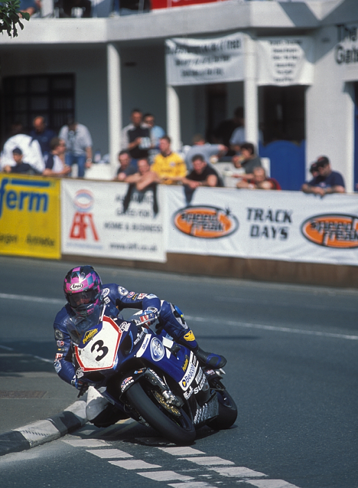
Quarterbridge (The Quarters or Quarter Dub: quarterlands of Ballabrooie and Ballaquayle) is situated soon after the 1 mile-marker measured from the TT Grandstand, part of the Snaefell Mountain Course used for the Isle of Man TT races, at the junction of the primary A1 Douglas to Peel road, A2 Douglas to Ramsey road and the A5 Douglas to Port Erin road which forms the boundary between the parishes of Braddan and Onchan in the Isle of Man. Name The Quarterbridge forms the boundary between the quarterlands of Ballabrooie and Ballaquayle. A quarterland is an old land division in the Isle of Man, which includes a farmstead or ''Kerroo'' within the quarterland. In this system four of these divisions became a ''treen'' and land rights were entrusted to a landholder, who in turn cultivated one of the quarterlands. The three other quarterlands were rented to freemen paying dues in the form of rents, produce, parish services including the maintenance of a small church or ''keeil'' with ... [...More Info...] [...Related Items...] OR: [Wikipedia] [Google] [Baidu] |
Snaefell Mountain Course
The Isle of Man TT Mountain Course or ''TT Course'' is a street and public rural road circuit located in the Isle of Man, used for motorcycle racing. The motorcycle ''TT Course'' is used principally for the Isle of Man TT Races and also the separate event of the Isle of Man Festival of Motorcycling for the Manx Grand Prix and Classic TT Races held in September of each year. The start-line for the Isle of Man TT Mountain Course is located on Glencrutchery Road in the town of Douglas, Isle of Man.Daily Express page 38 Friday 7 September 1979 The clockwise course has a lap of , from the start line at the TT Grandstand on Glencrutchery Road ( A2 Ramsey to Douglas) in the island's main town of Douglas. After negotiating urban streets, the racing circuit turns right to leave Douglas at Quarter Bridge, then proceeds along the A1 Douglas to Peel road through the villages of Braddan, Union Mills, Glen Vine, Crosby, and Greeba. The course then turns right at Ballacraine on to the ... [...More Info...] [...Related Items...] OR: [Wikipedia] [Google] [Baidu] |
Isle Of Man TT
The Isle of Man TT or Tourist Trophy races are an annual motorcycle racing event run on the Isle of Man in May/June of most years since its inaugural race in 1907 Isle of Man TT, 1907. The event is often called one of the most dangerous racing events in the world as List of Isle of Man TT Mountain Course fatalities, many competitors have died. Overview The Isle of Man TT is run in a Time trial, time-trial format on public roads closed to the public by an Act of Tynwald (the parliament of the Isle of Man). The event consists of one week of practice sessions followed by one week of racing. It has been a tradition, perhaps started by racing competitors in the early 1920s, for spectators to tour the Isle of Man TT Mountain Course, Snaefell Mountain Course on motorcycles during the Isle of Man TT on Mad Sunday, an informal and unofficial sanctioned event held on the Sunday between Practice Week and Race Week. The first Isle of Man TT race was held on Tuesday 28 May 1907 and was ca ... [...More Info...] [...Related Items...] OR: [Wikipedia] [Google] [Baidu] |
Isle Of Man Railway Stations
This article details each of the lines operated by the Isle of Man Railway, including the original line to Peel in the west, opened in 1873, followed by the Port Erin line the following year (which is still fully operational today), as well as the Manx Northern Railway's line between St John's and Ramsey and the Foxdale Railway's line between St John's and Foxdale (the latter two of which were independent companies bought out in 1905 by the Isle Of Man Railway Company). All lines The South Line (open) The line to Port Erin was the second to be opened by the railway company, in 1874 one year after the shorter line to Peel had been opened. This line's construction involved considerably more civil engineering work than the relatively straightforward westerly line, including two major rock cuttings on the climb out of Douglas railway station at "The Nunnery" and Keristal. The story goes that the work nearly bankrupted the contractors and the second cutting wa ... [...More Info...] [...Related Items...] OR: [Wikipedia] [Google] [Baidu] |
Douglas Railway Station
Douglas railway station ( Manx: ''Stashoon Raad Yiarn Ghoolish'') is the main terminus of the Isle of Man Railway and is located at the landward end of the quay in Douglas, the capital of the Isle of Man. It was once the hub for now closed lines to Peel, Ramsey and Foxdale. Location The station is located on the southern side of the island's capital, Douglas, and is at the far landward end of the North quay close to the old town and finance centre. It has car parking available for railway patrons on the site of the former goods yard and departure platforms and is served by nearby bus services from many locations on the island. The current station buildings in red Ruabon brick were constructed between 1887 and 1913 replacing timber constructions established upon the opening of the line in 1873. The site was reclaimed from marshland, the nearby Lake Road attesting this fact. History The Isle of Man Railway Company bought the site in 1872, and diverted the Douglas River to ... [...More Info...] [...Related Items...] OR: [Wikipedia] [Google] [Baidu] |
A5 Road (Isle Of Man)
"A" roads "B" roads Note: Many of these roads in rural areas do not lead to or from anywhere remotely notable, while many of the roads within towns and villages are very short indeed. This makes it problematic to include "to" or "from" destinations. "C" roads * C3 Switchback road * C4 Ballaleigh road * C5 Ballabooie road * C6 Thurot Cottage road * C7 Rhendoo road * C8 Garey road * C9 Ballamodda road * C10 Scholag road * C11 Ellerslie road * C12 Rushen Abbey road * C13 Jacks Lane, Lewaigue to Port-e-Vullen road * C14 Ballacorey road * C15 Dogmills to Regaby road * C16 Tynwald Hill road * C17 Gleneedle Road * C19 Orrisdale road * C20 Mullinaragher road * C21 Mount Murray Back road * C22 Little Mill road * C24 Kentraugh Back road * C25 Staarvey road * C26 Ballagawne road * C27 Port Cornaa road * C28 Killane road * C29 Old Windmill road * C30 Ballaterson road * C31 Dollagh Mooar road * C32 Glen Vine road * C33 Archallagan road * C34 Ballavar and L ... [...More Info...] [...Related Items...] OR: [Wikipedia] [Google] [Baidu] |
Braddan Bridge
Braddan Bridge (Irish: ''Naomh Breandán'', Saint Brendan of Clonfert, ''the Navigator'' or ''the Voyager'') is a bridge over the river Dhoo on the Douglas to Peel road, from which a halt on the Isle of Man Railway's first line to Peel took its name. It is a landmark on the Isle of Man TT road-race course, situated in countryside close to the outskirts of Douglas town where motorcycles slow to negotiate a left-right 'S' bend over the river. A traditional viewing spot with seating, in common with other vantage points around the local Douglas area, it is within walking distance of the Ferry Terminal where sea ferries from England, Scotland and Ireland traditionally disembarked day-trip or longer-stay passengers. Bridge and TT races The bridge is on the boundary between the parishes of Braddan and Onchan. It is situated between the 1st and 2nd Milestone road-side markers on the Snaefell Mountain Course used for the Isle of Man TT and Manx Grand Prix races, on the junction of ... [...More Info...] [...Related Items...] OR: [Wikipedia] [Google] [Baidu] |
Manx Language
Manx ( or , pronounced or ), also known as Manx Gaelic, is a Gaelic language of the insular Celtic branch of the Celtic language family, itself a branch of the Indo-European language family. Manx is the historical language of the Manx people. Although only few children native to the Isle of Man speak Manx as a first language, there has been a steady increase in the number of speakers since the death of Ned Maddrell in 1974. He was considered to be the last speaker to grow up in a Manx-speaking community environment. Despite this, the language has never fallen completely out of use, with a minority having some knowledge of it as a heritage language, and it is still an important part of the island's culture and cultural heritage. Manx is often cited as a good example of language revival efforts; in 2015, around 1,800 people had varying levels of second-language conversational ability. Since the late 20th century, Manx has become more visible on the island, with increa ... [...More Info...] [...Related Items...] OR: [Wikipedia] [Google] [Baidu] |
Railway Stations In The Isle Of Man
Rail transport (also known as train transport) is a means of transport that transfers passengers and goods on wheeled vehicles running on rails, which are incorporated in Track (rail transport), tracks. In contrast to road transport, where the vehicles run on a prepared flat surface, rail vehicles (rolling stock) are directionally guided by the tracks on which they run. Tracks usually consist of steel rails, installed on Railroad tie, sleepers (ties) set in track ballast, ballast, on which the rolling stock, usually fitted with metal wheels, moves. Other variations are also possible, such as "slab track", in which the rails are fastened to a concrete foundation resting on a prepared subsurface. Rolling stock in a rail transport system generally encounters lower friction, frictional resistance than rubber-tyred road vehicles, so passenger and freight cars (carriages and wagons) can be coupled into longer trains. The rail transport operations, operation is carried out by a ... [...More Info...] [...Related Items...] OR: [Wikipedia] [Google] [Baidu] |
Roads In The Isle Of Man
There are a number of transport services around the Isle of Man, mostly consisting of paved roads, public transport, rail services, sea ports and an airport. Roads The island has a total of of public roads, all of which are paved. Roads are numbered using a numbering scheme similar to the numbering schemes of Great Britain and Northern Ireland; each road is assigned a letter, which represents the road's category, followed by a 1 or 2 digit number. ''A'' roads are the main roads of the island whilst roads labelled ''B'', ''C'', ''D'' or ''U'' decrease in size and/or quality. (The C, D and U numbers are not marked on most maps or on signposts.) There is no national speed limit – some roads may be driven at any speed which is safe and appropriate. Careless and dangerous driving laws still apply, so one may not drive at absolutely any speed, and there are local speed limits on many roads. Many unrestricted roads have frequent bends which even the most experienced driver cann ... [...More Info...] [...Related Items...] OR: [Wikipedia] [Google] [Baidu] |


