|
Portpatrick
Portpatrick is a village and civil parish in the historical county of Wigtownshire, Dumfries and Galloway, Scotland. It is located on the west coast of the Rhins of Galloway. The parish is about in length and in breadth, covering . History Dating back some 700 years and built adjacent to the ruins of nearby Dunskey Castle, Portpatrick's position on the Rhins of Galloway affords visitors views of the Northern Irish coast to the west, with cliff-top walks and beaches both north and south. The Gulf Stream, flowing in from the north, gives the coastline a pleasant climate, in which subtropical plant life can flourish. Portpatrick has a Community Council, and an annual Life Boat Week, featuring parades, activities, and a firework display. There are bowls clubs, a golf club, many guesthouses and hotels, and rustic public houses. The village is also home to a mini putting course. By the inner harbour is the starting point of the Southern Upland Way, a long-distance walking route ... [...More Info...] [...Related Items...] OR: [Wikipedia] [Google] [Baidu] |
Portpatrick Railway
The Portpatrick and Wigtownshire Joint RailwaysThe final word is in the plural. was a network of railway lines serving sparsely populated areas of south-west Scotland. The title appeared in 1885 when the previously independent Portpatrick Railway (PPR) and Wigtownshire Railway (WR) companies were amalgamated by Act of Parliament into a new company jointly owned by the Caledonian Railway, Glasgow & South Western Railway, Midland Railway and the London & North Western Railway and managed by a committee called the Portpatrick and Wigtownshire Joint Committee. The Portpatrick Railway connected and , opened in 1861 and 1862 and was intended to revive the transit to the north of Ireland through Portpatrick, although Stranraer actually became the dominant port. The line became known as the ''Paddy'' because of its connection to Ireland. [...More Info...] [...Related Items...] OR: [Wikipedia] [Google] [Baidu] |
Portpatrick Old Kirk - Geograph
Portpatrick is a village and civil parish in the historical county of Wigtownshire, Dumfries and Galloway, Scotland. It is located on the west coast of the Rhins of Galloway. The parish is about in length and in breadth, covering . History Dating back some 700 years and built adjacent to the ruins of nearby Dunskey Castle, Portpatrick's position on the Rhins of Galloway affords visitors views of the Northern Irish coast to the west, with cliff-top walks and beaches both north and south. The Gulf Stream, flowing in from the north, gives the coastline a pleasant climate, in which subtropical plant life can flourish. Portpatrick has a Community Council, and an annual Life Boat Week, featuring parades, activities, and a firework display. There are bowls clubs, a golf club, many guesthouses and hotels, and rustic public houses. The village is also home to a mini putting course. By the inner harbour is the starting point of the Southern Upland Way, a long-distance walking route ... [...More Info...] [...Related Items...] OR: [Wikipedia] [Google] [Baidu] |
Rhins Of Galloway
gd, Na Rannaibh , photo = File:Luce Bay.jpg , photo_width = , photo_alt = , photo_caption = Looking south over the Rhins of Galloway towards Luce Bay , map = UK Scotland , map_width = , map_caption = The Rhins in the context of Scotland (map marks its highest point, Cairn Pat) , map_alt = , relief = 1 , location = Wigtownshire, Dumfries & Galloway , coordinates = , highest_point = Cairn Pat , highest_elevation = 182m , highest_coords = 54.86, -5.049 , area = , free_label_1 = Northern extremity , free_data_1 = Milleur Point , free_label_2 = Southern extermity , free_data_2 = Mull of Galloway (also Scotland's most southerly point) The Rhins of Galloway, otherwise known as the Rhins of Wigtownshire (or as The Rhins, also spelt The Rhinns; gd, Na Rannaibh), is a hammer-head peninsula in Dumfries and Galloway, Scotland. St ... [...More Info...] [...Related Items...] OR: [Wikipedia] [Google] [Baidu] |
Dunskey Castle
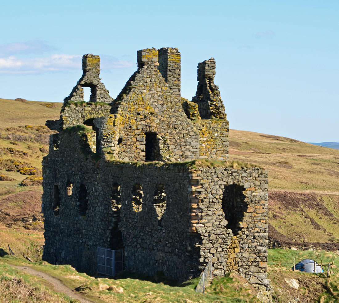
Dunskey Castle is a ruined, 12th-century tower house or castle, located south of the village of Portpatrick, Rhinns, Wigtownshire, on the south-west coast of Scotland. Dunskey Castle is a scheduled monument, a 'nationally important' archaeological site or historic building, given protection against unauthorised change. Description The three-storey L-plan structure is sited on a promontory, with a rock-cut ditch, wide by deep, defending the only access, from the north-east. The castle measures , with walls thick, although the building is now a roofless shell. The north-east wing is of a later date, and the foundations of a south range are visible. Near the castle are the remains of a watchtower, square, built on the cliff edge. Timothy Pont's map drawn c. 1580 – 1590 shows Dunskay Castle with 2 watchtowers on the cliff edge fronting the sea. Francis Grose's drawing dated show of 10 May 1790s the ruins of the foundations and sea-wall on the south, and what looks to be the ... [...More Info...] [...Related Items...] OR: [Wikipedia] [Google] [Baidu] |
Southern Upland Way
The Southern Upland Way is a coast-to-coast long-distance footpath in southern Scotland. The route links Portpatrick in the west and Cockburnspath in the east via the hills of the Southern Uplands. The Way is designated as one of Scotland's Great Trails by NatureScot and is the longest of the 29 Great Trails. The Southern Upland Way meets with seven of the other Great Trails: the Annandale Way, the Berwickshire Coastal Path, the Borders Abbeys Way, the Cross Borders Drove Road, the Mull of Galloway Trail, the Romans and Reivers Route and St Cuthbert's Way. The path is maintained by the local authorities of the two main council areas through which it passes: Dumfries and Galloway Council and Scottish Borders Council; a short section in the Lowther Hills lies in South Lanarkshire.Ordnance Survey ''Landranger'' 1:50000 map. Sheet 78 (Nithsdale & Annandale). It is primarily intended for walkers, but many parts are suitable for mountain bikers; some sections are also suitable for ... [...More Info...] [...Related Items...] OR: [Wikipedia] [Google] [Baidu] |
Stranraer
Stranraer ( , in Scotland also ; gd, An t-Sròn Reamhar ), also known as The Toon, is a town in Dumfries and Galloway, Scotland. It is located in the historical parish of Inch in the historic county of Wigtownshire. It lies on the shores of Loch Ryan, on the northern side of the isthmus joining the Rhins of Galloway to the mainland. Stranraer is Dumfries and Galloway's second-largest town, with a population including the immediate surrounding area of nearly 13,000 inhabitants. Stranraer is an administrative centre for the West Galloway Wigtownshire area of Dumfries and Galloway. It was formerly a ferry port, connecting Scotland with Belfast and Larne in Northern Ireland; the last service was transferred to nearby Cairnryan in November 2011. It lies by road southwest of Glasgow, miles southwest of Ayr and to the west of Dumfries. The name comes from Scottish Gaelic '' An t-Sròn Reamhar'' meaning "the broad headland" or "the fat nose". History The Battle of Loch Ryan was ... [...More Info...] [...Related Items...] OR: [Wikipedia] [Google] [Baidu] |
Wigtownshire
Wigtownshire or the County of Wigtown (, ) is one of the historic counties of Scotland, covering an area in the south-west of the country. Until 1975, Wigtownshire was an administrative county used for local government. Since 1975 the area has formed part of Dumfries and Galloway for local government purposes. Wigtownshire continues to be used as a territory for land registration, being a registration county. The historic county is all within the slightly larger Wigtown Area, which is one of the lieutenancy areas of Scotland and was used in local government as the Wigtown District from 1975 to 1996. Wigtownshire forms the western part of the medieval lordship of Galloway, which retained a degree of autonomy until it was fully absorbed by Scotland in the 13th century. In 1369, the part of Galloway east of the River Cree was placed under the control of a steward and so became known as the Stewartry of Kirkcudbright. The rest of Galloway remained under the authority of a sheriff, an ... [...More Info...] [...Related Items...] OR: [Wikipedia] [Google] [Baidu] |
Donaghadee
Donaghadee ( , ) is a small town in County Down, Northern Ireland. It lies on the northeast coast of the Ards Peninsula, about east of Belfast and about six miles (10 km) south east of Bangor. It is in the civil parish of Donaghadee and the historic barony of Ards Lower. It had a population of 6,869 people in the 2011 Census. History The name 'Donaghadee' comes from Irish ''Domhnach Daoi'', which has two possible meanings: "church of Daoi", after an unattested saint, or "church of the motte". Originally the site of a Gaelic ringfort, the Anglo-Normans built a motte-and-bailey castle on the site after they conquered the area in the late 12th century.Donaghadee History . Visit Donaghadee. Retrieved 21 November 2021. In the early 17th century, [...More Info...] [...Related Items...] OR: [Wikipedia] [Google] [Baidu] |
Dumfries And Galloway
Dumfries and Galloway ( sco, Dumfries an Gallowa; gd, Dùn Phrìs is Gall-Ghaidhealaibh) is one of 32 unitary council areas of Scotland and is located in the western Southern Uplands. It covers the counties of Scotland, historic counties of Dumfriesshire, Kirkcudbrightshire, and Wigtownshire, the latter two of which are collectively known as Galloway. The administrative centre and largest settlement is the town of Dumfries. The second largest town is Stranraer, on the North Channel (Great Britain and Ireland), North Channel coast, some to the west of Dumfries. Following the 1975 reorganisation of local government in Scotland, the three counties were joined to form a single regions and districts of Scotland, region of Dumfries and Galloway, with four districts within it. The districts were abolished in 1996, since when Dumfries and Galloway has been a unitary local authority. For lieutenancy areas of Scotland, lieutenancy purposes, the area is divided into three lieutenancy a ... [...More Info...] [...Related Items...] OR: [Wikipedia] [Google] [Baidu] |
Dunskey Castle2
Dunskey Estate (''also known as Portree Estate'') is north of Portpatrick on the west coast of Scotland. The B-listed mansion dates from the start of the twentieth century and replaced an earlier early-eighteenth century house. Since 2017 it has been used as a tourist, wedding and film venue. Prior to the early 1700s Dunskey Castle was the main building on the estate; it is now a ruined building and scheduled monument with no public access. The estate was the property of the Hunter-Blair family, later of Blairquhan in Ayrshire, and was acquired when Jane (or Jean) Blair of Dunskey, wife of James Hunter, succeeded her brother to Dunskey estates in 1777. A house dating from 1706 was extended in the 1830s. The Rev James Blair acquired the estate in 1648. Dunskey Estate has been in the Orr Ewing family since 1900. The house was built 1901-04 for Charles Lindsay Orr-Ewing Charles Lindsay Orr-Ewing (8 September 1860 – 24 December 1903) was a Scottish Tory A Tory () is a per ... [...More Info...] [...Related Items...] OR: [Wikipedia] [Google] [Baidu] |
Irish Sea Bridge
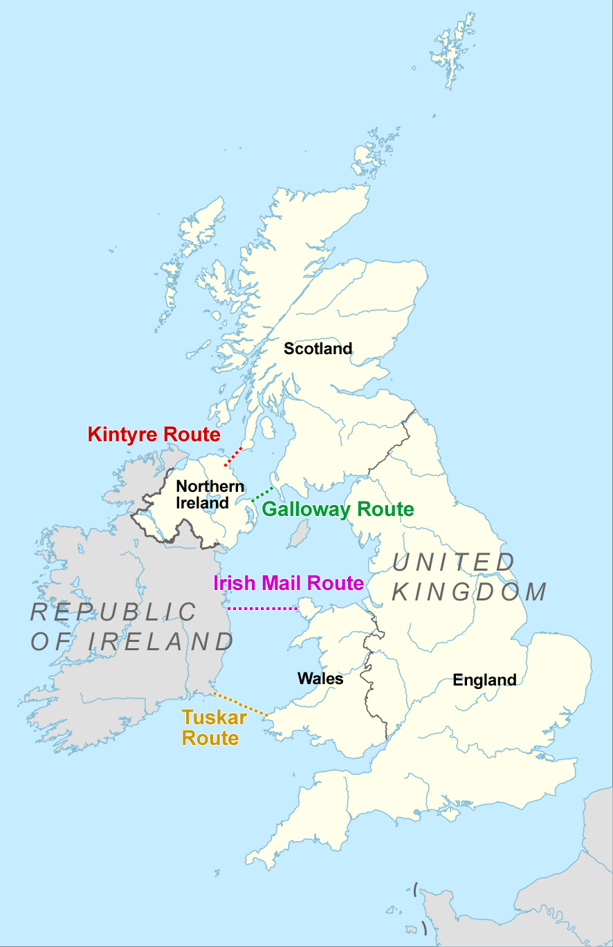
The Irish Sea Bridge, sometimes called the Celtic Crossing by the media, is a hypothetical rail and road bridge that would span the Irish Sea and connect the island of Ireland to the island of Great Britain. It is one of a number of such proposed fixed sea links across the British Isles. The bridge's length would depend upon the route taken; one such route, known as the Galloway route, would cross the North Channel, close to that taken by an existing ferry service, between Portpatrick in Dumfries and Galloway, and Larne in County Antrim, Northern Ireland, a distance of . The concept of an Irish Sea Bridge had been proposed many times since the Victorian Era. In 2018 Professor Alan Dunlop at the University of Liverpool revived the idea. By February 2020, British government officials began scoping the possible route and type of crossing. Particular risks to such a project include the depth of North Channel and the presence of a large underwater munitions dump at Beaufort's Dyke. I ... [...More Info...] [...Related Items...] OR: [Wikipedia] [Google] [Baidu] |
Inch, Wigtownshire
Inch is a Civil parishes in Scotland, civil parish in Dumfries and Galloway, southwest Scotland. It lies on the shore of Loch Ryan, in the traditional county of Wigtownshire. The parish is in length, and in one part nearly of the same breadth, comprising . Location The northern section of the parish lies between Loch Ryan and the Water of Luce and consists of hills and heath. The southern section lies chiefly in the isthmus between Loch Ryan and Luce Bay, and is low and gently undulating. The principal town is Stranraer, which is partly within the parish. The Water of Luce, which flows south into Luce Bay, divides the parish from New Luce to the east. Settlements At Lochans, Dumfries and Galloway, Lochans Village there is a Community Centre and Primary School. Nearby is Kilhilt (also spelt Kinhilt), which gave its name to the Barony of Killhelt. The village of Castle Kennedy, east of Stranraer, is named after the castle which was built in 1607, and burned down in 1716. Stra ... [...More Info...] [...Related Items...] OR: [Wikipedia] [Google] [Baidu] |


.jpg)

.jpg)
