|
Palić
Palić ( sr-Cyrl, Палић; hu, Palics; german: Palitsch) is a town located in the city of Subotica, North Bačka District, autonomous province of Vojvodina, Serbia. It is also located from the border between Serbia and Hungary. The town has a Hungarian ethnic majority and its population numbering 7,771 inhabitants (as of 2011 census). Many tourists come to Palić every year because of the Palić lake and spa. There are over 450 guest houses, and even a five-star hotel. It is known for its Palić European Film Festival which takes place every summer. In 2008 the life achievement award was presented to the British film director Ken Loach. Demographics Historical population *1961: 6,135 *1971: 7,253 *1981: 6,974 *1991: 7,375 *2002: 7,745 *2011: 7,771 Ethnic groups *Hungarians = 4,178 (53.95%) *Serbs = 1,930 (24.92%) *Croats = 399 (5.15%) *Yugoslavs = 351 (4.53%) *Bunjevci = 335 (4.33%) Cityscape Unique in Serbia, Palić and adjacent Subotica have the most buildings built i ... [...More Info...] [...Related Items...] OR: [Wikipedia] [Google] [Baidu] |
Palić Lake
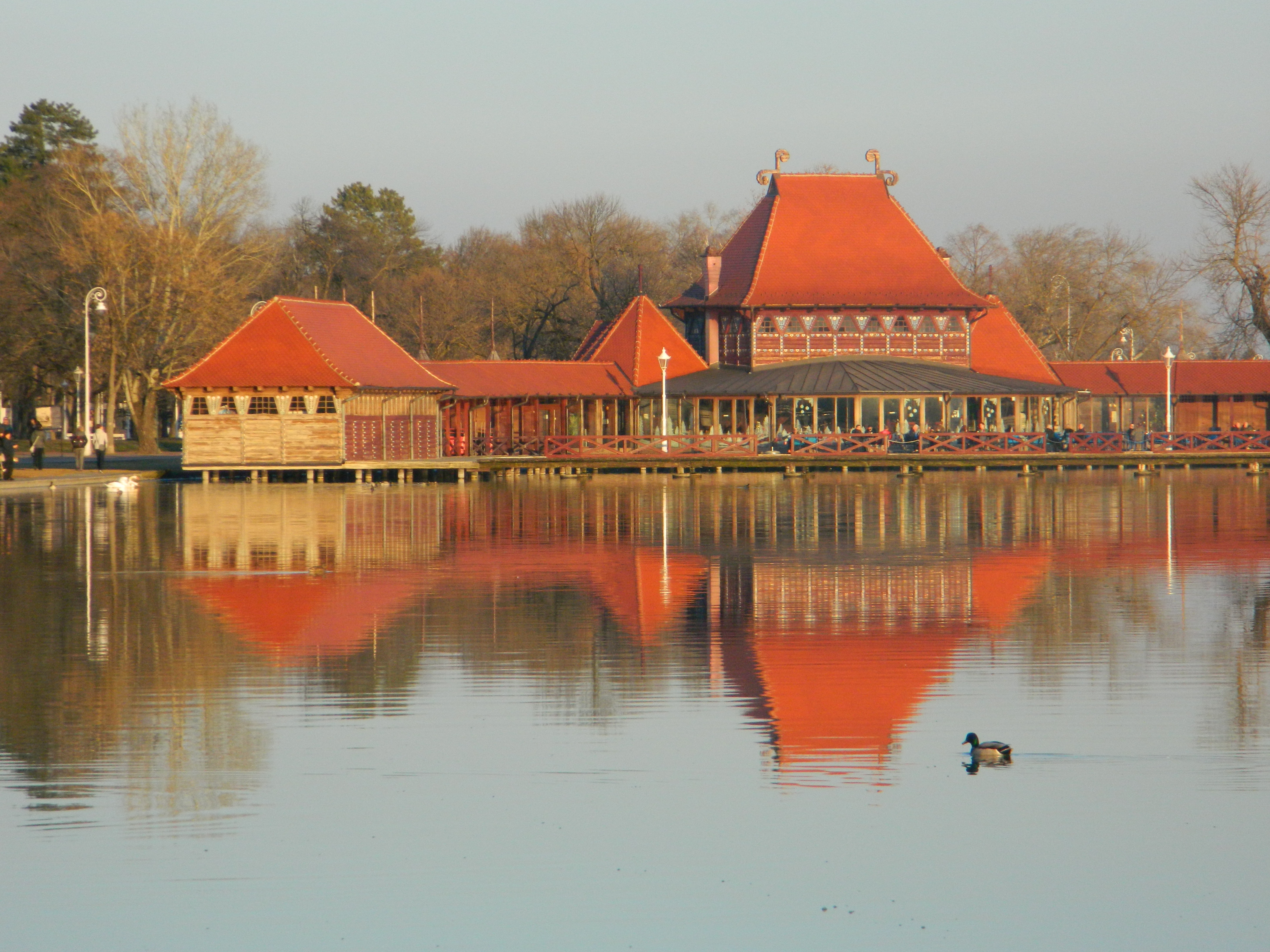
Palić ( sr-Cyrl, Палић; hu, Palics; german: Palitsch) is a town located in the city of Subotica, North Bačka District, autonomous province of Vojvodina, Serbia. It is also located from the border between Serbia and Hungary. The town has a Hungarian ethnic majority and its population numbering 7,771 inhabitants (as of 2011 census). Many tourists come to Palić every year because of the Palić lake and spa. There are over 450 guest houses, and even a five-star hotel. It is known for its Palić European Film Festival which takes place every summer. In 2008 the life achievement award was presented to the British film director Ken Loach. Demographics Historical population *1961: 6,135 *1971: 7,253 *1981: 6,974 *1991: 7,375 *2002: 7,745 *2011: 7,771 Ethnic groups *Hungarians = 4,178 (53.95%) *Serbs = 1,930 (24.92%) *Croats = 399 (5.15%) *Yugoslavs = 351 (4.53%) *Bunjevci = 335 (4.33%) Cityscape Unique in Serbia, Palić and adjacent Subotica have the most buildings buil ... [...More Info...] [...Related Items...] OR: [Wikipedia] [Google] [Baidu] |
Subotica
Subotica ( sr-cyrl, Суботица, ; hu, Szabadka) is a List of cities in Serbia, city and the administrative center of the North Bačka District in the autonomous province of Vojvodina, Serbia. Formerly the largest city of Vojvodina region, contemporary Subotica is now the second largest city in the province, following the city of Novi Sad. According to the 2011 census, the city itself has a population of 97,910, while the urban area of Subotica (with adjacent urban settlement of Palić included) has 105,681 inhabitants, and the population of metro area (the administrative area of the city) stands at 141,554 people. Name The name of the city has changed frequently over time.History of Subotica Retrieved 8 September 2022. The earliest known written name of the city was ''Zabotka'' or ''Zabatka'', [...More Info...] [...Related Items...] OR: [Wikipedia] [Google] [Baidu] |
Palić European Film Festival
Palić European Film Festival is a European film festival that takes place in the town of Palić (a lake resort near Subotica, north Serbia). As of 2019, it has been held 26 times. The Festival includes nine programs: Official Selection, Young Spirit of Europe; Parallels and Encounters Programme, Hommage programme, Country in Focus, New Hungarian film, Eco Dox, Children’s programme and Underground Spirit. See also *Serbian culture Serbian culture is a term that encompasses the artistic, culinary, literary, musical, political and social elements that are representative of Serbs and Serbia. History The Byzantine Empire had a great influence on Serbian culture as it i ... References External linkswww.palicfilmfestival.com Film festivals in Serbia Palić Culture of Vojvodina {{Europe-film-festival-stub ... [...More Info...] [...Related Items...] OR: [Wikipedia] [Google] [Baidu] |
Újszász
Újszász is a town in Jász-Nagykun-Szolnok county, in the Northern Great Plain region of central Hungary. Geography It covers an area of and has a population of 6153 people (2015). Twin towns – sister cities Újszász is twinned with: * Auzeville-Tolosane, France (1997) * Ciceu, Romania (2005) * Gmina Dębica __NOTOC__ Gmina Dębica is a rural gmina (administrative district) in Dębica County, Subcarpathian Voivodeship, in south-eastern Poland. Its seat is the town of Dębica, although the town is not part of the territory of the gmina. The gmina cover ..., Poland (2004) * Palić (Subotica), Serbia (2013) References External links * in Hungarian Populated places in Jász-Nagykun-Szolnok County {{Jasz-geo-stub ... [...More Info...] [...Related Items...] OR: [Wikipedia] [Google] [Baidu] |
Art Nouveau
Art Nouveau (; ) is an international style of art, architecture, and applied art, especially the decorative arts. The style is known by different names in different languages: in German, in Italian, in Catalan, and also known as the Modern Style (British Art Nouveau style), Modern Style in English. It was popular between 1890 and 1910 during the Belle Époque period, and was a reaction against the academic art, eclecticism and historicism of 19th century architecture and decoration. It was often inspired by natural forms such as the sinuous curves of plants and flowers. Other characteristics of Art Nouveau were a sense of dynamism and movement, often given by asymmetry or whiplash lines, and the use of modern materials, particularly iron, glass, ceramics and later concrete, to create unusual forms and larger open spaces.Sembach, Klaus-Jürgen, ''L'Art Nouveau'' (2013), pp. 8–30 One major objective of Art Nouveau was to break down the traditional distinction between fine ... [...More Info...] [...Related Items...] OR: [Wikipedia] [Google] [Baidu] |
Vojvodina
Vojvodina ( sr-Cyrl, Војводина}), officially the Autonomous Province of Vojvodina, is an autonomous province that occupies the northernmost part of Serbia. It lies within the Pannonian Basin, bordered to the south by the national capital Belgrade and the Sava and Danube Rivers. The administrative center, Novi Sad, is the second-largest city in Serbia. The historic regions of Banat, Bačka, and Syrmia overlap the province. Modern Vojvodina is multi-ethnic and multi-cultural, with some 26 ethnic groups and six official languages. About two million people, nearly 27% of Serbia's population, live in the province. Naming ''Vojvodina'' is also the Serbian word for voivodeship, a type of duchy overseen by a voivode. The Serbian Voivodeship, a precursor to modern Vojvodina, was an Austrian province from 1849 to 1860. Its official name is the Autonomous Province of Vojvodina. Its name in the province's six official languages is: * Croatian: ''Autonomna Pokrajina Vojvodina'' * ... [...More Info...] [...Related Items...] OR: [Wikipedia] [Google] [Baidu] |
List Of Places In Serbia
This is the list of populated places in Serbia (excluding Kosovo), as recorded by the 2002 census, sorted alphabetically by municipalities. Settlements denoted as "urban" (towns and cities) are marked bold. Population for every settlement is given in brackets. The same list in alphabetic order is in List of populated places in Serbia (alphabetic). A Ada Aleksandrovac Aleksinac Alibunar Apatin Aranđelovac Arilje B Babušnica Bač Bačka Palanka Bačka Topola Bački Petrovac Bajina Bašta Barajevo Batočina Bečej Bela Crkva Bela Palanka Beočin Blace Bogatić Bojnik Boljevac Bor Bosilegrad Brus Bujanovac C Crna Trava Č Čačak Čajetina Čoka Čukarica Ć Ćićevac Ćuprija D Despotovac Dimitrovgrad Doljevac G Gadžin Han Golubac Gornji Milanovac Grocka I Inđija Irig Ivanjica J Jagodina K Kanjiža Kikinda Kladovo Knić Knjaževac Koceljeva Kosjerić Kovačica Kovi ... [...More Info...] [...Related Items...] OR: [Wikipedia] [Google] [Baidu] |
Pánd
Pánd is a village in Pest county, Hungary. Location Pánd is located between the towns of Káva and Tápióbicske along the minor road connecting Nagykáta and Monor. It is almost entirely located in the valleys of Őr Hill and Dobos Hill. A smaller stream crosses the southern part of the settlement that empties into the river Tápió which is part of the Danube's drainage basin. Twin towns – twin cities * Celje – Slovenia (1998) * Nanterre – France (1999) * Syddjurs Municipality – Denmark (2000) * Andrijevica – Montenegro (2000) * Maasmechelen – Belgium (2001) * Sveti Nikole – North Macedonia (2002) * Marstrand – Sweden (2004) * Vaslui – Romania (2004) * Schwerte – Germany (2005) * Ancona – Italy (2009) * Kamzë – Albania (2013) * Vigo – Spain (2014) * Dornbirn – Austria (2015) * Yambol – Bulgaria (2016) * São Domingos de Rana – Portugal (2018) * Bugojno – Bosnia and Herzegovina (2018) * Stará Ľubovňa – Slovakia ... [...More Info...] [...Related Items...] OR: [Wikipedia] [Google] [Baidu] |
Hungary
Hungary ( hu, Magyarország ) is a landlocked country in Central Europe. Spanning of the Carpathian Basin, it is bordered by Slovakia to the north, Ukraine to the northeast, Romania to the east and southeast, Serbia to the south, Croatia and Slovenia to the southwest, and Austria to the west. Hungary has a population of nearly 9 million, mostly ethnic Hungarians and a significant Romani minority. Hungarian, the official language, is the world's most widely spoken Uralic language and among the few non-Indo-European languages widely spoken in Europe. Budapest is the country's capital and largest city; other major urban areas include Debrecen, Szeged, Miskolc, Pécs, and Győr. The territory of present-day Hungary has for centuries been a crossroads for various peoples, including Celts, Romans, Germanic tribes, Huns, West Slavs and the Avars. The foundation of the Hungarian state was established in the late 9th century AD with the conquest of the Carpathian Basin by Hungar ... [...More Info...] [...Related Items...] OR: [Wikipedia] [Google] [Baidu] |
Humid Subtropical Climate
A humid subtropical climate is a zone of climate characterized by hot and humid summers, and cool to mild winters. These climates normally lie on the southeast side of all continents (except Antarctica), generally between latitudes 25° and 40° and are located poleward from adjacent tropical climates. It is also known as warm temperate climate in some climate classifications. Under the Köppen climate classification, ''Cfa'' and ''Cwa'' climates are either described as humid subtropical climates or warm temperate climates. This climate features mean temperature in the coldest month between (or ) and and mean temperature in the warmest month or higher. However, while some climatologists have opted to describe this climate type as a "humid subtropical climate", Köppen himself never used this term. The humid subtropical climate classification was officially created under the Trewartha climate classification. In this classification, climates are termed humid subtropical when the ... [...More Info...] [...Related Items...] OR: [Wikipedia] [Google] [Baidu] |
Köppen Climate Classification
The Köppen climate classification is one of the most widely used climate classification systems. It was first published by German-Russian climatologist Wladimir Köppen (1846–1940) in 1884, with several later modifications by Köppen, notably in 1918 and 1936. Later, the climatologist Rudolf Geiger (1894–1981) introduced some changes to the classification system, which is thus sometimes called the Köppen–Geiger climate classification system. The Köppen climate classification divides climates into five main climate groups, with each group being divided based on seasonal precipitation and temperature patterns. The five main groups are ''A'' (tropical), ''B'' (arid), ''C'' (temperate), ''D'' (continental), and ''E'' (polar). Each group and subgroup is represented by a letter. All climates are assigned a main group (the first letter). All climates except for those in the ''E'' group are assigned a seasonal precipitation subgroup (the second letter). For example, ''Af'' indi ... [...More Info...] [...Related Items...] OR: [Wikipedia] [Google] [Baidu] |
Tisza
The Tisza, Tysa or Tisa, is one of the major rivers of Central and Eastern Europe. Once, it was called "the most Hungarian river" because it flowed entirely within the Kingdom of Hungary. Today, it crosses several national borders. The Tisza begins near Rakhiv in Ukraine, at the confluence of the White Tisa and Black Tisa, which is at coordinates 48.07465560782065, 24.24443465360461 (the former springs in the Chornohora mountains; the latter in the Gorgany range). From there, the Tisza flows west, roughly following Ukraine's borders with Romania and Hungary, then shortly as border between Slovakia and Hungary, later into Hungary, and finally into Serbia. It enters Hungary at Tiszabecs. It traverses Hungary from north to south. A few kilometers south of the Hungarian city of Szeged, it enters Serbia. Finally, it joins the Danube near the village of Stari Slankamen in Vojvodina, Serbia. The Tisza drains an area of about and has a length of Its mean annual discharge is seas ... [...More Info...] [...Related Items...] OR: [Wikipedia] [Google] [Baidu] |


