|
Pweto Airport
Pweto Airport is an airport serving Pweto, a town in the Democratic Republic of the Congo. Pweto is on the northernmost corner of Lake Mweru, and on the border with Zambia. The airport is north of the town. It is new, replacing the previous dirt runway to the west of Pweto. It was built by Australian company Mawson West in 2012–2013 to serve its proposed copper mine to the east at Kapulo. After construction of the runway, Mawson put the mining plans on hold due to low copper prices, and was subsequently acquired and taken private. See also * * *Transport in the Democratic Republic of the Congo *List of airports in the Democratic Republic of the Congo This is a list of airports in the Democratic Republic of the Congo, sorted by location. Airports Airport names shown in bold indicate the airport has scheduled service on commercial airlines. See also * Transport in the Democratic Republic ... References Airports in Haut-Katanga Province {{DRCongo-airport- ... [...More Info...] [...Related Items...] OR: [Wikipedia] [Google] [Baidu] |
Pweto
Pweto is a town in the Haut-Katanga Province of the Democratic Republic of the Congo (DRC). It is the administrative center of Pweto Territory. The town was the scene of a decisive battle in December 2000 during the Second Congo War which resulted in both sides making more active efforts to achieve peace. Pweto and the surrounding region were devastated during the war. little had been done to restore infrastructure or rebuild the economy. The town is served by Pweto Airport. Location Pweto lies at the north end of Lake Mweru on the border with Zambia. The Luvua River, a headstream of the Congo River, leaves the lake just west of Pwetu to flow north to its confluence with the Lualaba River opposite the town of Ankoro. Where the Luvua exits the lake it runs through a series of violent rapids, falling several meters from the lake level. The Mitumba mountains rise to the west, forming a giant barrier between the lake and the Congo Basin broken by the Luvua valley. A fertile plain str ... [...More Info...] [...Related Items...] OR: [Wikipedia] [Google] [Baidu] |
Democratic Republic Of The Congo
The Democratic Republic of the Congo (french: République démocratique du Congo (RDC), colloquially "La RDC" ), informally Congo-Kinshasa, DR Congo, the DRC, the DROC, or the Congo, and formerly and also colloquially Zaire, is a country in Central Africa. It is bordered to the northwest by the Republic of the Congo, to the north by the Central African Republic, to the northeast by South Sudan, to the east by Uganda, Rwanda, and Burundi, and by Tanzania (across Lake Tanganyika), to the south and southeast by Zambia, to the southwest by Angola, and to the west by the South Atlantic Ocean and the Cabinda exclave of Angola. By area, it is the second-largest country in Africa and the 11th-largest in the world. With a population of around 108 million, the Democratic Republic of the Congo is the most populous officially Francophone country in the world. The national capital and largest city is Kinshasa, which is also the nation's economic center. Centered on the Cong ... [...More Info...] [...Related Items...] OR: [Wikipedia] [Google] [Baidu] |
Lake Mweru
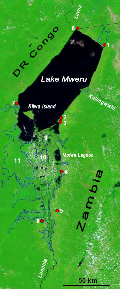
Lake Mweru (also spelled ''Mwelu'', ''Mwero'') is a freshwater lake on the longest arm of Africa's second-longest river, the Congo. Located on the border between Zambia and Democratic Republic of the Congo, it makes up of the total length of the Congo, lying between its Luapula River (upstream) and Luvua River (downstream) segments.Google Earth accessed 29 March 2007. When in flood Lake Bangweulu and its swamps may temporarily have a larger area, but not a larger volume. Mweru means 'lake' in a number of Bantu languages, so it is often referred to as just 'Mweru'.The ''Northern Rhodesia Journal'' online at NZRAM.org: J B W Anderson: "Kilwa Island and the Luapula." Vol II, No. 3 pp87–88 (1954) Physical geography Mweru is mainly fed by the Luapula River, which comes in through swamps from the south, and the Kalungwishi River from the east. At its north end the lake is drained by the Luvua River, which flows in a northwesterly direction to join the Lualaba River and thence to th ... [...More Info...] [...Related Items...] OR: [Wikipedia] [Google] [Baidu] |
Zambia
Zambia (), officially the Republic of Zambia, is a landlocked country at the crossroads of Central Africa, Central, Southern Africa, Southern and East Africa, although it is typically referred to as being in Southern Africa at its most central point. Its neighbours are the Democratic Republic of the Congo to the north, Tanzania to the northeast, Malawi to the east, Mozambique to the southeast, Zimbabwe and Botswana to the south, Namibia to the southwest, and Angola to the west. The capital city of Zambia is Lusaka, located in the south-central part of Zambia. The nation's population of around 19.5 million is concentrated mainly around Lusaka in the south and the Copperbelt Province to the north, the core economic hubs of the country. Originally inhabited by Khoisan peoples, the region was affected by the Bantu expansion of the thirteenth century. Following the arrival of European exploration of Africa, European explorers in the eighteenth century, the British colonised the r ... [...More Info...] [...Related Items...] OR: [Wikipedia] [Google] [Baidu] |
Kapulo
The Kapulo mine is a cassiterite mine and a planned copper mine in the Democratic Republic of the Congo. It is located near a village of the same name. In 2007 one of the two remaining full FARDC brigades in Katanga was stationed in Pweto Territory. This brigade, the 62nd, was illegally exploiting the Cassiterite mine in Kapulo. The ore is exported through the Musosa, Moba Territory border crossing into Zambia, bypassing customs posts. The Australian mining company Mawson West acquired the rights to a copper mine in the area from Anvil Mining in May 2010. The ore deposit is on the eastern edge the Katanga sedimentary basin, and is north of the main copper belt in the Kundelungu Plateau zone. There are two ore zones, Shaba and Safari, separated by the long Kapulo fault. In July 2011, Mawson West announced that a feasibility study for an open cut copper mine at Kapulo had given positive results. The find was valued at $141 million. Basic reserves are estimated at 200,000 tonn ... [...More Info...] [...Related Items...] OR: [Wikipedia] [Google] [Baidu] |
Transport In The Democratic Republic Of The Congo
Ground transport in the Democratic Republic of the Congo (DRC) has always been difficult. The terrain and climate of the Congo Basin present serious barriers to road and rail construction, and the distances are enormous across this vast country. Furthermore, chronic economic mismanagement and internal conflict has led to serious under-investment over many years. On the other hand, the DRC has thousands of kilometres of navigable waterways, and traditionally water transport has been the dominant means of moving around approximately two-thirds of the country. Transport problems As an illustration of transport difficulties in the DRC, even before wars damaged the infrastructure, the so-called "national" route, used to get supplies to Bukavu from the seaport of Matadi, consisted of the following: *Matadi to Kinshasa – rail *Kinshasa to Kisangani – river boat *Kisangani to Ubundu – rail *Ubundu to Kindu – river boat *Kindu to Kalemie – rail *Kalemie to Kalundu (the lake po ... [...More Info...] [...Related Items...] OR: [Wikipedia] [Google] [Baidu] |
List Of Airports In The Democratic Republic Of The Congo ...
This is a list of airports in the Democratic Republic of the Congo, sorted by location. Airports Airport names shown in bold indicate the airport has scheduled service on commercial airlines. See also * Transport in the Democratic Republic of the Congo * List of airports by ICAO code: F#FZ - Democratic Republic of the Congo (DRC), formerly known as Zaire * Wikipedia: WikiProject Aviation/Airline destination lists: Africa#Congo, Democratic Republic of the References * * * External links * Lists of airports in the Democratic Republic of the Congo: *Great Circle Mapper*World Aero Data* {{DRC topics Congo Airports Airports Congo, Democratic Republic of the The Democratic Republic of the Congo (french: République démocratique du Congo (RDC), colloquially "La RDC" ), informally Congo-Kinshasa, DR Congo, the DRC, the DROC, or the Congo, and formerly and also colloquially Zaire, is a country in ... [...More Info...] [...Related Items...] OR: [Wikipedia] [Google] [Baidu] |

