|
Promethei Terra
Promethei Terra is a large Martian region covering 3300 km at its broadest extent. It lies to the east of the massive Hellas basin. Like much of the southern part of the planet it is a heavily cratered, highland region. Promethei Terra was named for a classic albedo feature of Mars, with the original name derived from that of the Greek god Prometheus. Promethei Terra lies mostly in the Hellas quadrangle of Mars. Lobate debris aprons One very important feature common in Promethei Terra are piles of material surrounding cliffs. These materials are called lobate debris aprons (LDAs). Recently, research with the Shallow Radar on the Mars Reconnaissance Orbiter has provided strong evidence that the LDAs are glaciers that are covered with a thin layer of rocks. Large amounts of water ice are believed to be in the LDAs. Available evidence strongly suggests this area accumulated snow in the past. When the tilt (obliquity) of Mars increases the southern ice cap releases large ... [...More Info...] [...Related Items...] OR: [Wikipedia] [Google] [Baidu] |
Hellas Basin
Hellas Planitia is a plain located within the huge, roughly circular impact basin Hellas located in the southern hemisphere of the planet Mars. Hellas is the third- or fourth-largest known impact crater in the Solar System. The basin floor is about deep, deeper than the Moon's South Pole-Aitken basin, and extends about east to west.The part below zero datum, see Geography of Mars#Zero elevation It is centered at Hellas Planitia spans the boundary between the Hellas quadrangle and the Noachis quadrangle. Description With a diameter of about , it is the largest unambiguous impact structure on the planet; the obscured Utopia Planitia is slightly larger (the Borealis Basin, if it proves to be an impact crater, is considerably larger). Hellas Planitia is thought to have been formed during the Late Heavy Bombardment period of the Solar System, approximately 4.1 to 3.8 billion years ago, when a protoplanet or large asteroid hit the surface. The altitude difference between the ... [...More Info...] [...Related Items...] OR: [Wikipedia] [Google] [Baidu] |
Albedo Feature
An albedo feature is a large area on the surface of a planet (or other Solar System body) which shows a contrast in brightness or darkness (albedo) with adjacent areas. Historically, albedo features were the first (and usually only) features to be seen and named on Mars and Mercury. Early classical maps (such as those of Schiaparelli and Antoniadi) showed only albedo features, and it was not until the arrival of space probes that other surface features such as craters could be seen. On bodies other than Mars and Mercury, an albedo feature is sometimes called a regio. On bodies with a very thick atmosphere like Venus or Titan, permanent albedo features cannot be seen using ordinary optical telescopes because the surface is not visible, and only clouds and other transient atmospheric phenomena are seen. The '' Cassini–Huygens'' probe observed multiple albedo features on Titan after its arrival in Saturn's orbit in 2004. The first albedo feature ever seen on another plane ... [...More Info...] [...Related Items...] OR: [Wikipedia] [Google] [Baidu] |
Prometheus
In Greek mythology, Prometheus (; , , possibly meaning "forethought")Smith"Prometheus". is a Titan god of fire. Prometheus is best known for defying the gods by stealing fire from them and giving it to humanity in the form of technology, knowledge, and more generally, civilization. In some versions of the myth, he is also credited with the creation of humanity from clay. Prometheus is known for his intelligence and for being a champion of humankind, and is also generally seen as the author of the human arts and sciences. He is sometimes presented as the father of Deucalion, the hero of the flood story. The punishment of Prometheus as a consequence of the theft of fire and giving it to humans is a popular subject of both ancient and modern culture. Zeus, king of the Olympian gods, sentenced Prometheus to eternal torment for his transgression. Prometheus was bound to a rock, and an eagle—the emblem of Zeus—was sent to eat his liver (in ancient Greece, the liver was thoug ... [...More Info...] [...Related Items...] OR: [Wikipedia] [Google] [Baidu] |
Hellas Quadrangle
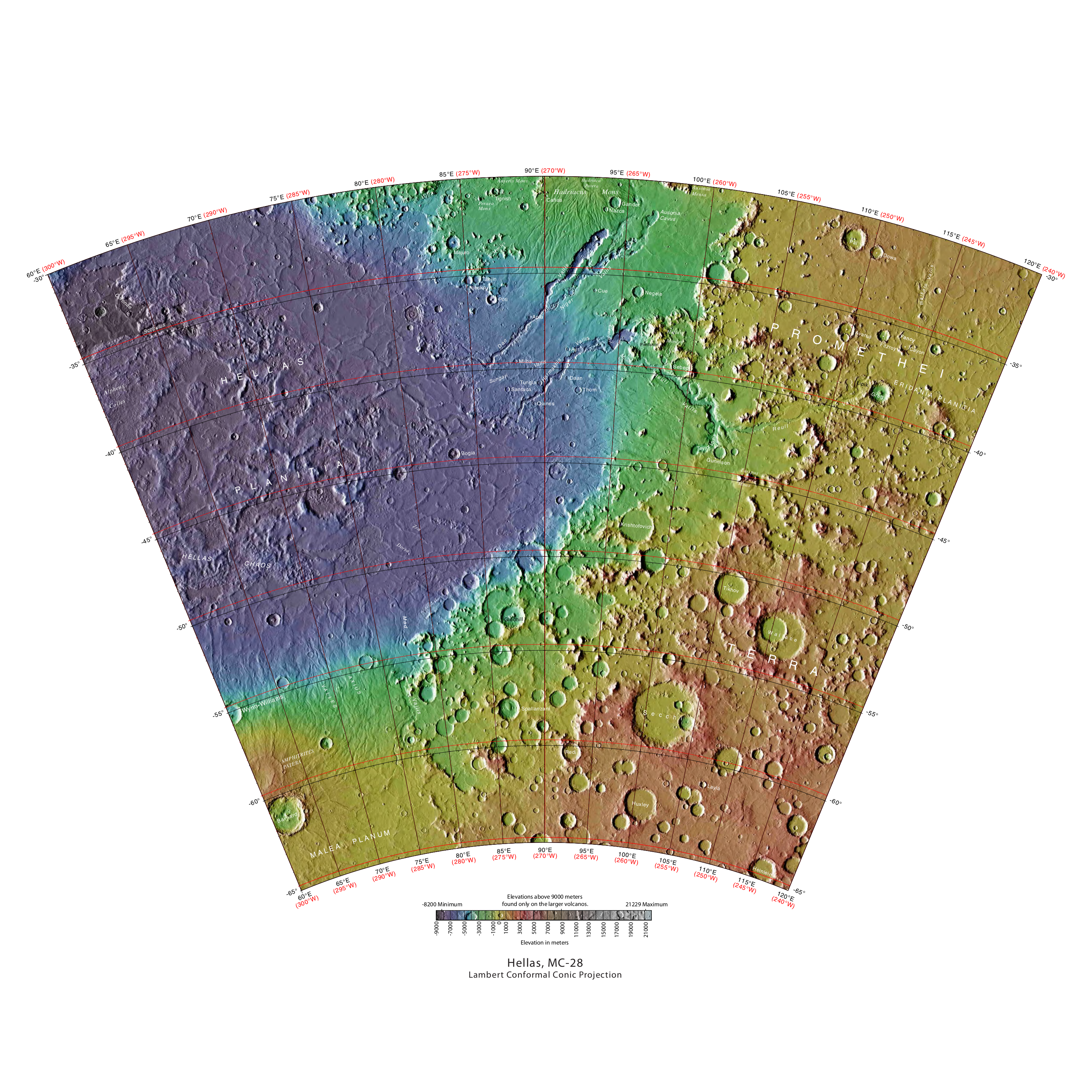
The Hellas quadrangle is one of a series of 30 quadrangle maps of Mars used by the United States Geological Survey (USGS) Astrogeology Research Program. The Hellas quadrangle is also referred to as MC-28 (Mars Chart-28). The Hellas quadrangle covers the area from 240° to 300° west longitude and 30° to 65° south latitude on the planet Mars. Within the Hellas quadrangle lies the classic features Hellas Planitia and Promethei Terra. Many interesting and mysterious features have been discovered in the Hellas quadrangle, including the giant river valleys Dao Vallis, Niger Vallis, Harmakhis, and Reull Vallis—all of which may have contributed water to a lake in the Hellas basin in the distant past. Many places in the Hellas quadrangle show signs of ice in the ground, especially places with glacier-like flow features. Hellas Basin The Hellas quadrangle contains part of the Hellas Basin, the largest known impact crater on the surface of Mars and the second largest in the solar sys ... [...More Info...] [...Related Items...] OR: [Wikipedia] [Google] [Baidu] |
Lobate Debris Apron
Lobate debris aprons (LDAs) are geological features on Mars, first seen by the Viking Orbiters, consisting of piles of rock debris below cliffs. These features have a convex topography and a gentle slope from cliffs or escarpments, which suggest flow away from the steep source cliff. In addition, lobate debris aprons can show surface lineations as do rock glaciers on the Earth. File:Wikictxp13clifflda.jpg, alt=Wide view of mesa with CTX showing Cliff face and location of lobate debris apron (LDA) Location is Ismenius Lacus quadrangle., Wide view of mesa with CTX showing cliff face and location of lobate debris apron (LDA) Location is Ismenius Lacus quadrangle. File:Wikifretesp 028313 2220cliff.jpg, Enlargement of previous CTX image of mesa This image shows the cliff face and detail in the LDA. Image taken with HiRISE under HiWish program. Location is Ismenius Lacus quadrangle. File:Wikildaf03 036777 2287.jpg, alt=Lobate debris aprons (LDAs) around a mesa, as seen by CTX. Mesa ... [...More Info...] [...Related Items...] OR: [Wikipedia] [Google] [Baidu] |
Mars Reconnaissance Orbiter
''Mars Reconnaissance Orbiter'' (MRO) is a spacecraft designed to study the geology and climate of Mars, provide reconnaissance of future landing sites, and relay data from surface missions back to Earth. It was launched on August 12, 2005, and reached Mars on March 10, 2006. In November 2006, after five months of aerobraking, it entered its final science orbit and began its primary science phase. The cost to develop and operate MRO through the end of its prime mission in 2010 was . The spacecraft continues to operate at Mars, far beyond its intended design life. Due to its critical role as a high-speed data-relay for ground missions, NASA intends to continue the mission as long as possible, at least through the late 2020s. Pre-launch After the twin failures of the ''Mars Climate Orbiter'' and the Mars Polar Lander missions in 1999, NASA reorganized and replanned its Mars Exploration Program. In October 2000, NASA announced its reformulated Mars plans, which reduced the numb ... [...More Info...] [...Related Items...] OR: [Wikipedia] [Google] [Baidu] |
Glacier
A glacier (; ) is a persistent body of dense ice that is constantly moving under its own weight. A glacier forms where the accumulation of snow exceeds its Ablation#Glaciology, ablation over many years, often Century, centuries. It acquires distinguishing features, such as Crevasse, crevasses and Serac, seracs, as it slowly flows and deforms under stresses induced by its weight. As it moves, it abrades rock and debris from its substrate to create landforms such as cirques, moraines, or fjords. Although a glacier may flow into a body of water, it forms only on land and is distinct from the much thinner sea ice and lake ice that form on the surface of bodies of water. On Earth, 99% of glacial ice is contained within vast ice sheets (also known as "continental glaciers") in the polar regions, but glaciers may be found in mountain ranges on every continent other than the Australian mainland, including Oceania's high-latitude oceanic island countries such as New Zealand. Between lati ... [...More Info...] [...Related Items...] OR: [Wikipedia] [Google] [Baidu] |
Romer Lake
Romer Lake ( da, Romer Sø) is a land-locked freshwater fjord at the northern end of King Frederick VIII Land, near Greenland's northeastern coast. The Danish military base/weather station Nord —the only inhabited place in the area— lies to the northeast. The lake and its surroundings are part of the Northeast Greenland National Park zone. Romer Lake was first mapped in 1933 by Lauge Koch during aerial surveys made during the 1931–34 Three-year Expedition to East Greenland ''(Treårsekspeditionen)''. It was likely named after the Danish Astronomer/Inventor Ole Rømer (1644–1710). Geography Romer Lake is located at the western end of the Crown Prince Christian Land peninsula to the west of the Princess Elizabeth Alps. It lies in long and narrow depression running parallel to the Denmark Fjord system further north and stretching roughly from NE to SW for about . A glacier has its terminus at the northern end and the Nunataami Elv river valley flows out of the southern e ... [...More Info...] [...Related Items...] OR: [Wikipedia] [Google] [Baidu] |
Climate Of Mars
The climate of Mars has been a topic of scientific curiosity for centuries, in part because it is the only terrestrial planet whose surface can be directly observed in detail from the Earth with help from a telescope. Although Mars is smaller than the Earth, 11% of Earth's mass, and 50% farther from the Sun than the Earth, its climate has important similarities, such as the presence of polar ice caps, seasonal changes and observable weather patterns. It has attracted sustained study from planetologists and climatologists. While Mars' climate has similarities to Earth's, including periodic ice ages, there are also important differences, such as much lower thermal inertia. Mars' atmosphere has a scale height of approximately , 60% greater than that on Earth. The climate is of considerable relevance to the question of whether life is or ever has been present on the planet. The climate briefly received more interest in the news due to NASA measurements indicating increased sublima ... [...More Info...] [...Related Items...] OR: [Wikipedia] [Google] [Baidu] |
Glacier
A glacier (; ) is a persistent body of dense ice that is constantly moving under its own weight. A glacier forms where the accumulation of snow exceeds its Ablation#Glaciology, ablation over many years, often Century, centuries. It acquires distinguishing features, such as Crevasse, crevasses and Serac, seracs, as it slowly flows and deforms under stresses induced by its weight. As it moves, it abrades rock and debris from its substrate to create landforms such as cirques, moraines, or fjords. Although a glacier may flow into a body of water, it forms only on land and is distinct from the much thinner sea ice and lake ice that form on the surface of bodies of water. On Earth, 99% of glacial ice is contained within vast ice sheets (also known as "continental glaciers") in the polar regions, but glaciers may be found in mountain ranges on every continent other than the Australian mainland, including Oceania's high-latitude oceanic island countries such as New Zealand. Between lati ... [...More Info...] [...Related Items...] OR: [Wikipedia] [Google] [Baidu] |


