|
Port Carlisle
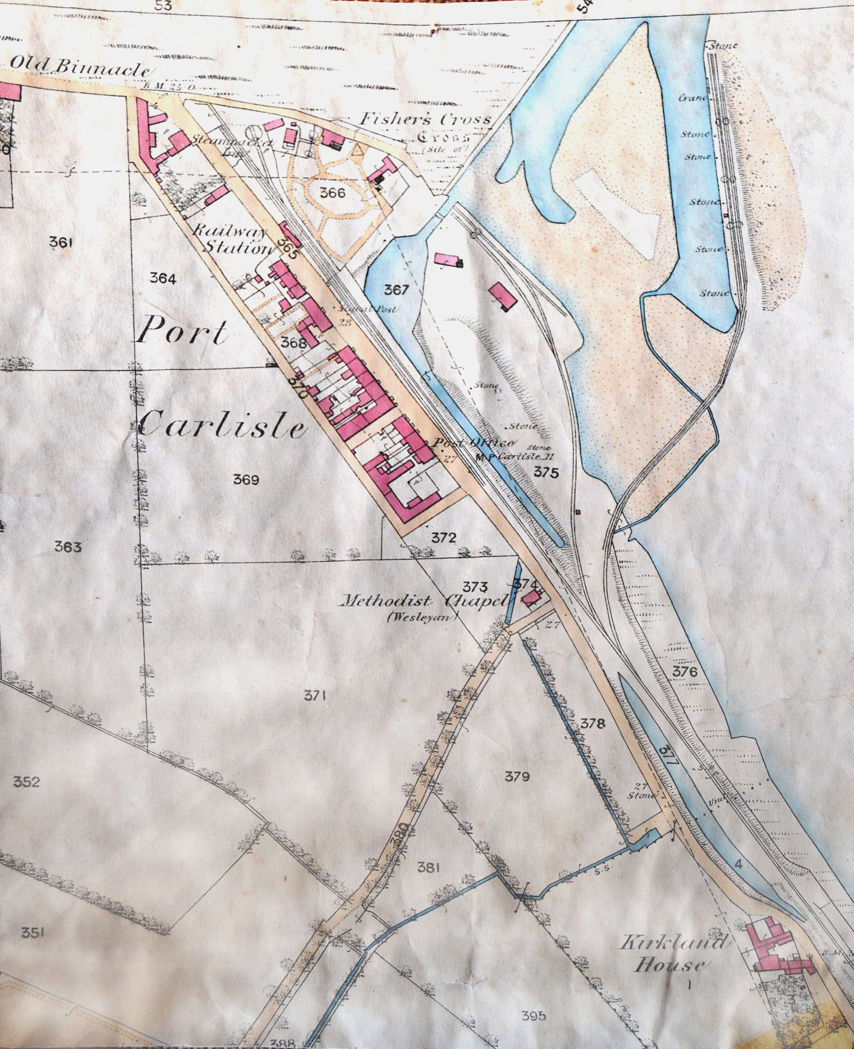
Port Carlisle is a coastal village in Allerdale, Cumbria, England. It is in the civil parish of Bowness-on-Solway. Its original name was Fisher's Cross, but when it became the terminus of the Carlisle Canal it was renamed Port Carlisle. During the lifetime of the canal it was of considerable importance as the sea outlet for Carlisle, handling both freight and passengers. With the building of the much bigger Silloth docks, the canal was redundant. Some through trade continued via the Port Carlisle Railway, but diminished as the Solway silted up. The canal and railway The Carlisle canal was built to allow sea access for Carlisle to Ireland, Scotland and Liverpool. The sea terminus was at Port Carlisle, and a sea lock and basin was built there in 1819. Four years later the canal was completed to Carlisle, and Port Carlisle became the centre of a good deal of transhipment trade, and passenger traffic via steam packets. However, the canal was short-lived due to competition from dee ... [...More Info...] [...Related Items...] OR: [Wikipedia] [Google] [Baidu] |
Bowness-on-Solway
Bowness-on-Solway is a village in the Allerdale borough of Cumbria, England. It is situated to the west of Carlisle on the southern side of the Solway Firth estuary separating England and Scotland. The civil parish had a population of 1,126 at the 2011 census. The western end of Hadrian's Wall is a notable tourist destination, though the Wall itself is no longer to be seen here above ground. The west end of the Hadrian's Wall Path is marked by a pavilion on the small coastal cliff at Bowness. The village is part of the Solway Coast Area of Outstanding Natural Beauty. Etymology 'Bowness' means 'rounded', or bow-shaped headland', from either the Old English 'boga', 'bow', and 'næss', or, more probably, the Old Norse 'bogi' and 'nes'. Roman era The village is situated on the site of the Roman fort called Maia, the second largest on Hadrian's Wall. There was also a small civilian settlement (''vicus'') outside the south gate of this fort. Governance Bowness-on-Solway is pa ... [...More Info...] [...Related Items...] OR: [Wikipedia] [Google] [Baidu] |
Allerdale
Allerdale is a non-metropolitan district of Cumbria, England, with borough status. Its council is based in Workington and the borough has a population of 93,492 according to the 2001 census, increasing to 96,422 at the 2011 Census. The Borough of Allerdale was formed under the Local Government Act 1972, on 1 April 1974 by the merger of the municipal borough of Workington, the urban districts of Maryport, Cockermouth and Keswick; and the rural districts of Cockermouth and Wigton, all of which were within the administrative county of Cumberland. In 1995 Allerdale was granted borough status. The name derives from the ancient region of Allerdale, represented latterly by the two wards of Cumberland, called Allerdale-above-Derwent and Allerdale-below-Derwent, the present borough corresponding largely to the latter with parts of the former. Much of the area during the medieval period was a royal forest subject to forest law. In July 2021 the Ministry of Housing, Communities an ... [...More Info...] [...Related Items...] OR: [Wikipedia] [Google] [Baidu] |
Cumbria
Cumbria ( ) is a ceremonial and non-metropolitan county in North West England, bordering Scotland. The county and Cumbria County Council, its local government, came into existence in 1974 after the passage of the Local Government Act 1972. Cumbria's county town is Carlisle, in the north of the county. Other major settlements include Barrow-in-Furness, Kendal, Whitehaven and Workington. The administrative county of Cumbria consists of six districts ( Allerdale, Barrow-in-Furness, Carlisle, Copeland, Eden and South Lakeland) and, in 2019, had a population of 500,012. Cumbria is one of the most sparsely populated counties in England, with 73.4 people per km2 (190/sq mi). On 1 April 2023, the administrative county of Cumbria will be abolished and replaced with two new unitary authorities: Westmorland and Furness (Barrow-in-Furness, Eden, South Lakeland) and Cumberland ( Allerdale, Carlisle, Copeland). Cumbria is the third largest ceremonial county in England by area. It i ... [...More Info...] [...Related Items...] OR: [Wikipedia] [Google] [Baidu] |
Workington (UK Parliament Constituency)
Workington is a Constituencies of the Parliament of the United Kingdom, constituency in Cumbria represented in the House of Commons of the United Kingdom, House of Commons of the Parliament of the United Kingdom, UK Parliament since 2019 United Kingdom general election, 2019 by Mark Jenkinson, a Conservative Party (UK), Conservative. Boundaries The constituency covers much of the north-west of Cumbria, corresponding largely to the Allerdale borough, except for the areas around Wigton and Keswick, Cumbria, Keswick. As well as Workington itself, the constituency contains the towns of Cockermouth, Maryport, Aspatria and Silloth. Boundary review 1918–1950: The Municipal Borough of Workington, the Urban Districts of Arlecdon and Frizington, Aspatria, Harrington, and Maryport, and parts of the Rural Districts of Cockermouth, Whitehaven, and Wigton. 1950–1983: The Municipal Borough of Workington, the Urban Districts of Cockermouth, Keswick, and Maryport, and the Rural District of ... [...More Info...] [...Related Items...] OR: [Wikipedia] [Google] [Baidu] |
Civil Parish
In England, a civil parish is a type of administrative parish used for local government. It is a territorial designation which is the lowest tier of local government below districts and counties, or their combined form, the unitary authority. Civil parishes can trace their origin to the ancient system of ecclesiastical parishes, which historically played a role in both secular and religious administration. Civil and religious parishes were formally differentiated in the 19th century and are now entirely separate. Civil parishes in their modern form came into being through the Local Government Act 1894, which established elected parish councils to take on the secular functions of the parish vestry. A civil parish can range in size from a sparsely populated rural area with fewer than a hundred inhabitants, to a large town with a population in the tens of thousands. This scope is similar to that of municipalities in Continental Europe, such as the communes of France. However, ... [...More Info...] [...Related Items...] OR: [Wikipedia] [Google] [Baidu] |
Carlisle Canal
The Carlisle Canal opened in 1823, to link Carlisle to the Solway Firth, to facilitate the transport of goods to and from the city. It was a short-lived venture, being replaced by a railway which used the canal bed for most of its route in 1854. History The River Eden flows through the city of Carlisle, and into the Solway Firth. There were coal mines at Maryport, a little further down the coast, and prior to 1720, places along the river were supplied with coal by boats. However, this trade ended in 1720, when duties were levied on all goods carried around the coast by sea, and it became cheaper to transport the coal by land. Three traders from Carlisle, John Hicks, Henry Orme and Thomas Pattinson, sought an Act of Parliament which would waive the coastwise duties between Ellen Foot, as Maryport was then known, and Bank End, which was locate on the river close to Carlisle. The Act enabled them to build wharves, cranes and warehouses, and to dredge the river. They obtained the Act in ... [...More Info...] [...Related Items...] OR: [Wikipedia] [Google] [Baidu] |
Silloth
Silloth (sometimes known as Silloth-on-Solway) is a port town and civil parish in the Allerdale borough of Cumbria, England. Historically in the county of Cumberland, the town is an example of a Victorian seaside resort in the North of England. Silloth had a population of 2,932 at the 2001 Census, falling slightly to 2,906 at the 2011 Census. Location It sits on the shoreline of the Solway Firth, north of Workington and west of Carlisle. The town of Maryport lies south, down the B5300 coast road which also passes through the villages of Blitterlees, Beckfoot, Mawbray, and Allonby. Wigton is east, along the B5302 road, which also passes through the village of Abbeytown, southeast. History Silloth developed in the 1860s onwards around the terminus of the railway from Carlisle and associated docks which had begun construction in 1855 to replace Port Carlisle as the deep-water port for Carlisle. Workers from the factories of Carlisle were presented with access to t ... [...More Info...] [...Related Items...] OR: [Wikipedia] [Google] [Baidu] |
Port Carlisle Railway
There were two interlinked railways on the south shore of the Solway Firth. The Port Carlisle Dock and Railway Company was opened in 1854, following the route of a former canal, intended to connect Port Carlisle, to which sea-going ships could navigate, with the city of Carlisle. The Carlisle and Silloth Bay Railway and Dock Company was built as an extension of the Port Carlisle line, opening in 1856, because silting of the Solway was making Port Carlisle unusable. The two railways operated collaboratively, but neither was successful financially and insolvency seemed inevitable. However the North British Railway (NBR) was building the line that became the Waverley Route from Edinburgh to Carlisle. The established railways at Carlisle obstructed the NBR's intended access, so the NBR leased the Port Carlisle and the Silloth companies, and connected with them at the Port Carlisle's station in Carlisle. The NBR sent goods traffic for English destinations on to Silloth and by coasta ... [...More Info...] [...Related Items...] OR: [Wikipedia] [Google] [Baidu] |
Carlisle
Carlisle ( , ; from xcb, Caer Luel) is a city that lies within the Northern England, Northern English county of Cumbria, south of the Anglo-Scottish border, Scottish border at the confluence of the rivers River Eden, Cumbria, Eden, River Caldew, Caldew and River Petteril, Petteril. It is the administrative centre of the City of Carlisle district which, (along with Cumbria County Council) will be replaced by Cumberland (district), Cumberland Council in April 2023. The city became an established settlement during the Roman Empire to serve forts on Hadrian's Wall. During the Middle Ages, the city was an important military stronghold due to its proximity to the Kingdom of Scotland. Carlisle Castle, still relatively intact, was built in 1092 by William II of England, William Rufus, served as a prison for Mary, Queen of Scots in 1568 and now houses the Duke of Lancaster's Regiment and the Border Regiment Museum. In the early 12th century, Henry I of England, Henry I allowed a pri ... [...More Info...] [...Related Items...] OR: [Wikipedia] [Google] [Baidu] |
Drumburgh Railway Station
Drumburgh railway station was near the village of Drumburgh (pronounced "Drumbruff"), Cumbria, England. It was the junction station for the Port Carlisle Railway branch and the Silloth branch, serving both as a junction and transfer station and also serving the small village of Drumburgh. The station closed on 4 July 1955; nothing now remains of the station. The line to Silloth closed on 7 September 1964 as part of the Beeching cuts. Port Carlisle was two and a half miles away by train and Glasson was one and a quarter miles away. The journey time was nine minutes, although Glasson was a request stop.Cumbria Railways Retrieved : 2012-08-23 History [...More Info...] [...Related Items...] OR: [Wikipedia] [Google] [Baidu] |
Port Carlisle Railway Station
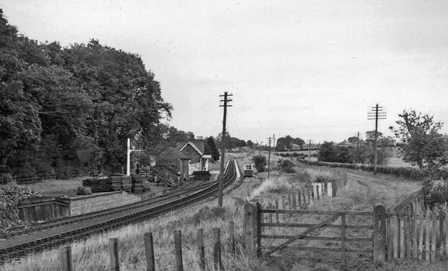
Port Carlisle railway station was a railway station in Port Carlisle, Cumbria; the terminus on the Port Carlisle Railway, serving the village and old port and the steamer service to Liverpool that ran from here until 1856, when it was transferred to Silloth. Port Carlisle was two and a half miles away by train from Drumburgh and Glasson was one and a quarter miles away. The journey time to Drumburgh was nine minutes, although Glasson was a request stop. History A port was built in 1819 at the hamlet of Fisher's Cross, later renamed Port Carlisle, and four years later, in 1821, the eleven and a half mile-long Carlisle Navigation Canal was built to take goods to Carlisle. The canal was closed in 1853 and the canal basin at Carlisle and parts of the canal were filled in by the Port Carlisle Railway Company, who constructed a railway that started passenger services commenced in 1854, discontinuing them two years later when the Carlisle & Silloth Bay Railway & Dock Company's (C& ... [...More Info...] [...Related Items...] OR: [Wikipedia] [Google] [Baidu] |
List Of Places In Cumbria
This is a list of cities, towns and villages in the county of Cumbria, England. A *Abbeytown, Ackenthwaite, Adgarley, Aglionby * Aiketgate, Aikhead, Aikshaw, Aikton, Ainstable, Aisgill * Albyfield, Aldingham, Aldoth, Allenwood * Allhallows, Allithwaite, Allonby * Alston, Alston Moor *Ambleside * Angerton, Allerdale, Angerton, South Lakeland, Annaside, Anthorn *Appleby-in-Westmorland, Applethwaite *Arkleby, Arlecdon, Armaside, Armathwaite * Arnaby, Arnside, Arrad Foot, Arthuret, Asby *Ashgill, Askam-in-Furness, Askham, Askerton *Aspatria, Aughertree, Ayside B *Backbarrow, Baggrow, Baldwinholme, Bampton, Bampton Grange * Bandrake Head, Banks, Barber Green, Barbon * Barclose, Bardsea, Barepot, Barras *Barrow Island, Barrow-in-Furness * Barrows Green, Barton *Bassenthwaite *Baycliff, Bayles, Beanthwaite, Beaumont * Beck Bottom, Beck Foot, Beck Head, Beck Side * Beckces, Beckermet, Beckfoot, Beckside *Beetham, Belah, Belle Vue, B ... [...More Info...] [...Related Items...] OR: [Wikipedia] [Google] [Baidu] |


