|
Poor Servants Of The Mother Of God
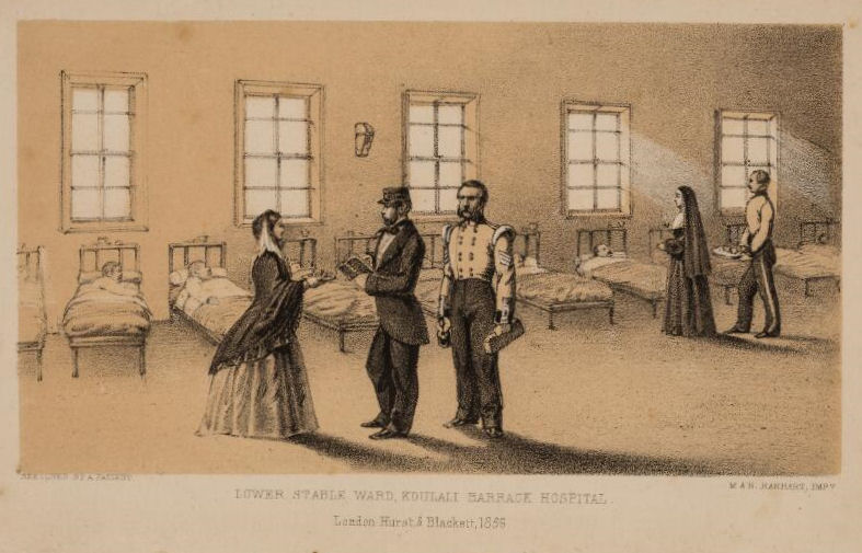
The Poor Servants of the Mother of God are a religious congregation founded in 1869 by Mary Magdalen of the Sacred Heart, Frances Margaret Taylor. She was closely assisted by her friend and benefactor Lady Georgiana Fullerton, and following her death, by her husband, A G Fullerton (1808-1907). History Frances Taylor had served as a nurse in the Crimea, where she encountered the Sisters of Mercy. She was received into the Roman Catholic Church by Father Woollett on 14 April 1855, and later wrote a book about her wartime experiences. Upon her return to England, she consulted Henry Edward Manning, rector of St Mary of the Angels, Bayswater, who put her in touch with Catholic charitable organisations, allowing her to work with the London poor as she desired.Steele, Francesca. "Frances Margaret Taylor. ... [...More Info...] [...Related Items...] OR: [Wikipedia] [Google] [Baidu] |
Frances Margaret Taylor
Frances Margaret Taylor, whose religious name was Mother Magdalen of the Sacred Heart (20 January 1832 – 9 June 1900) was an English nurse, editor and writer, nun, and Superior General and founder of the Roman Catholic religious congregation the Poor Servants of the Mother of God. Early life Frances Taylor was born in Stoke Rochford, the youngest of ten children of Henry Taylor (1777–1842), Anglican Rector of a rural Lincolnshire parish, and his wife Louisa Maria Jones (1793–1869). Her paternal grandfather Richard Taylor (fl.1745–1829) had been rector of parishes in Wiltshire and Hampshire. On her mother's side, her family were merchants and shopkeepers in the City of London. Her father, a graduate of Lincoln College, Oxford, had been a curate at St Mary Abbots, Kensington, where in 1816 he married. His final appointment was to Stoke Rochford in 1824, where he was instituted by his patron, the vicar of Kensington, Thomas Rennell (scholar), whose High Church sympathies ... [...More Info...] [...Related Items...] OR: [Wikipedia] [Google] [Baidu] |
Margate
Margate is a seaside resort, seaside town on the north coast of Kent in south-east England. The town is estimated to be 1.5 miles long, north-east of Canterbury and includes Cliftonville, Garlinge, Palm Bay, UK, Palm Bay and Westbrook, Kent, Westbrook. The town has been a significant maritime port since the Middle Ages, and was associated with Dover as part of the Cinque Ports in the 15th century. It became a popular place for holidaymakers in the 18th century, owing to easy access via the Thames, and later with the arrival of the railways. Popular landmarks include the sandy beaches and the Dreamland Margate, Dreamland amusement park. During the late 20th century, the town went into decline along with other British seaside resorts, but attempts are being made to revitalise the economy. History Margate was listed in the Domesday Book of 1086 as lying within the hundred of Thanet and the county of Kent. Margate was recorded as "Meregate" in 1264 and as "Margate" in 1299, b ... [...More Info...] [...Related Items...] OR: [Wikipedia] [Google] [Baidu] |
Selkirk, Scottish Borders
Selkirk is a town and historic royal burgh in the Scottish Borders council district of southeastern Scotland. It lies on the Ettrick Water, a tributary of the River Tweed. The people of the town are known as Souters, which means cobblers (shoe makers and menders). At the time of the 2011 census, Selkirk's population was 5,784. History Selkirk was formerly the county town of Selkirkshire. Selkirk is one of the oldest Royal Burghs in Scotland and is the site of the earliest settlements in what is now the Scottish Borders. The town's name means "church by the hall" from the Old English ''sele'' ("hall" or "manor") and ''cirice'' ("church"). Selkirk was the site of the first Borders abbey, a community of Tironensian monks who moved to Kelso Abbey during the reign of King David I. In 1113, King David I granted Selkirk large amounts of land. William Wallace was declared guardian of Scotland in the town at the Kirk o' the Forest in 1297. Selkirk sent a contingent of 80 men to fi ... [...More Info...] [...Related Items...] OR: [Wikipedia] [Google] [Baidu] |
Rhyl
Rhyl (; cy, Y Rhyl, ) is a seaside town and community (Wales), community in Denbighshire, Wales. The town lies within the Historic counties of Wales, historic boundaries of Flintshire (historic), Flintshire, on the north-east coast of Wales at the mouth of the River Clwyd (Welsh language, Welsh: ''Afon Clwyd''). To the west is Kinmel Bay and Towyn, to the east Prestatyn, and to the southeast Rhuddlan and St Asaph. At the United Kingdom Census 2011, 2011 Census, Rhyl had a population of 25,149, with Rhyl–Kinmel Bay having 31,229. Rhyl forms a conurbation with Prestatyn and its two outlying villages, the Rhyl/Prestatyn Built-up area, whose 2011 population of 46,267 makes it north Wales's most populous non-city (the city of Wrexham's being greater). Rhyl was once an elegant Victorian era, Victorian resort town but suffered rapid decline around the 1990s and 2000s but has since been improved by major regeneration around and in the town. Etymology Early documents refer to a dwel ... [...More Info...] [...Related Items...] OR: [Wikipedia] [Google] [Baidu] |
Liverpool
Liverpool is a city and metropolitan borough in Merseyside, England. With a population of in 2019, it is the 10th largest English district by population and its metropolitan area is the fifth largest in the United Kingdom, with a population of 2.24 million. On the eastern side of the Mersey Estuary, Liverpool historically lay within the ancient hundred of West Derby in the county of Lancashire. It became a borough in 1207, a city in 1880, and a county borough independent of the newly-created Lancashire County Council in 1889. Its growth as a major port was paralleled by the expansion of the city throughout the Industrial Revolution. Along with general cargo, freight, and raw materials such as coal and cotton, merchants were involved in the slave trade. In the 19th century, Liverpool was a major port of departure for English and Irish emigrants to North America. It was also home to both the Cunard and White Star Lines, and was the port of registry of the ocean li ... [...More Info...] [...Related Items...] OR: [Wikipedia] [Google] [Baidu] |
Paris
Paris () is the capital and most populous city of France, with an estimated population of 2,165,423 residents in 2019 in an area of more than 105 km² (41 sq mi), making it the 30th most densely populated city in the world in 2020. Since the 17th century, Paris has been one of the world's major centres of finance, diplomacy, commerce, fashion, gastronomy, and science. For its leading role in the arts and sciences, as well as its very early system of street lighting, in the 19th century it became known as "the City of Light". Like London, prior to the Second World War, it was also sometimes called the capital of the world. The City of Paris is the centre of the Île-de-France region, or Paris Region, with an estimated population of 12,262,544 in 2019, or about 19% of the population of France, making the region France's primate city. The Paris Region had a GDP of €739 billion ($743 billion) in 2019, which is the highest in Europe. According to the Economist Intelli ... [...More Info...] [...Related Items...] OR: [Wikipedia] [Google] [Baidu] |
Dublin
Dublin (; , or ) is the capital and largest city of Republic of Ireland, Ireland. On a bay at the mouth of the River Liffey, it is in the Provinces of Ireland, province of Leinster, bordered on the south by the Dublin Mountains, a part of the Wicklow Mountains range. At the 2016 census of Ireland, 2016 census it had a population of 1,173,179, while the preliminary results of the 2022 census of Ireland, 2022 census recorded that County Dublin as a whole had a population of 1,450,701, and that the population of the Greater Dublin Area was over 2 million, or roughly 40% of the Republic of Ireland's total population. A settlement was established in the area by the Gaels during or before the 7th century, followed by the Vikings. As the Kings of Dublin, Kingdom of Dublin grew, it became Ireland's principal settlement by the 12th century Anglo-Norman invasion of Ireland. The city expanded rapidly from the 17th century and was briefly the second largest in the British Empire and sixt ... [...More Info...] [...Related Items...] OR: [Wikipedia] [Google] [Baidu] |
Streatham
Streatham ( ) is a district in south London, England. Centred south of Charing Cross, it lies mostly within the London Borough of Lambeth, with some parts extending into the neighbouring London Borough of Wandsworth. Streatham was in Surrey before becoming part of the County of London in 1889, and then Greater London in 1965. The area is identified in the London Plan as one of 35 major centres in Greater London. History Streatham means "the hamlet on the street". The street in question, the London to Brighton Way, was the Roman road from the capital Londinium to the south coast near Portslade, today within Brighton and Hove. It is likely that the destination was a Roman port now lost to coastal erosion, which has been tentatively identified with 'Novus Portus' mentioned in Ptolemy's Geographia. The road is confusingly referred to as Stane Street (Stone Street) in some sources and diverges from the main London-Chichester road at Kennington. After the departure of the ... [...More Info...] [...Related Items...] OR: [Wikipedia] [Google] [Baidu] |
Rome
, established_title = Founded , established_date = 753 BC , founder = King Romulus (legendary) , image_map = Map of comune of Rome (metropolitan city of Capital Rome, region Lazio, Italy).svg , map_caption = The territory of the ''comune'' (''Roma Capitale'', in red) inside the Metropolitan City of Rome (''Città Metropolitana di Roma'', in yellow). The white spot in the centre is Vatican City. , pushpin_map = Italy#Europe , pushpin_map_caption = Location within Italy##Location within Europe , pushpin_relief = yes , coordinates = , coor_pinpoint = , subdivision_type = Country , subdivision_name = Italy , subdivision_type2 = Region , subdivision_name2 = Lazio , subdivision_type3 = Metropolitan city , subdivision_name3 = Rome Capital , government_footnotes= , government_type = Strong Mayor–Council , leader_title2 = Legislature , leader_name2 = Capitoline Assemb ... [...More Info...] [...Related Items...] OR: [Wikipedia] [Google] [Baidu] |
St Helens, Merseyside
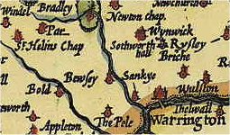
St Helens () is a town in Merseyside, England, with a population of 102,629. It is the administrative centre of the Metropolitan Borough of St Helens, which had a population of 176,843 at the United Kingdom Census 2001, 2001 Census. St Helens is in the south-west of the Historic counties of England, historic county of Lancashire, north of the River Mersey. The town historically lay within the ancient Lancashire division of West Derby (hundred), West Derby known as a hundred (county division), ''hundred''. The town initially started as a small settlement in the Township (England), township of Windle, St Helens, Windle but, by the mid 1700s, the town had become synonymous with a wider area; by 1838, it was formally made responsible for the administration of the four townships of Eccleston, St Helens, Eccleston, Parr, St Helens, Parr, Sutton, St Helens, Sutton and Windle. In 1868, the town was created by incorporation as a municipal borough and later became a county borough in 1887 ... [...More Info...] [...Related Items...] OR: [Wikipedia] [Google] [Baidu] |
Roehampton
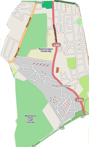
Roehampton is an area in southwest London, in the Putney SW15 postal district, and takes up a far western strip running north to south of the London Borough of Wandsworth. It contains a number of large council house estates and is home to the University of Roehampton. Etymology The ''Roe'' in Roehampton's name is thought to refer to the large number of rooks that still inhabit the area. Location Roehampton is centred about 6.3 miles (roughly 10 km) south-west of Charing Cross. It occupies high land, with Barnes to the north, Putney and Putney Heath to the east, and Richmond Park and Richmond Park Golf Course to the west. To the south is Roehampton Vale, that straddles the A3, with Wimbledon Common and Putney Vale beyond. History Roehampton was originally a small village – with only 14 houses during the reign of Henry VII – with the area largely forest and heath. The population gradually increased in the 18th and 19th centuries as it became a favoured residential ou ... [...More Info...] [...Related Items...] OR: [Wikipedia] [Google] [Baidu] |
County Cork
County Cork ( ga, Contae Chorcaí) is the largest and the southernmost county of Ireland, named after the city of Cork, the state's second-largest city. It is in the province of Munster and the Southern Region. Its largest market towns are Mallow, Macroom, Midleton, and Skibbereen. the county had a population of 581,231, making it the third- most populous county in Ireland. Cork County Council is the local authority for the county, while Cork City Council governs the city of Cork and its environs. Notable Corkonians include Michael Collins, Jack Lynch, Roy Keane, Sonia O'Sullivan and Cillian Murphy. Cork borders four other counties: Kerry to the west, Limerick to the north, Tipperary to the north-east and Waterford to the east. The county contains a section of the Golden Vale pastureland that stretches from Kanturk in the north to Allihies in the south. The south-west region, including West Cork, is one of Ireland's main tourist destinations, known for its rugged coast ... [...More Info...] [...Related Items...] OR: [Wikipedia] [Google] [Baidu] |

.jpg)


