|
Pontrilas Railway Station
Pontrilas railway station is a former station which served the Herefordshire villages of Pontrilas and Ewyas Harold, and was a little distance from Grosmont, in Monmouthshire, Wales. It was located on the Welsh Marches Line between Hereford and Abergavenny. The Golden Valley Railway ran from here through to the Midland Railway line at Hay on Wye. The station is now a private house offering B&B and a self-catering cottage. The station closed in 1958 (see Pontrilas). The remaining railway infrastructure includes the operating signal box. The sidings are still in use for infrastructure work and, less often, as a freight loop. It is at the end of the long climb from Abergavenny; freight and steam specials on this route provide a noisy spectacle coming through the station site. In the southbound direction the long section between Pontrilas and Abergavenny frequently results in trains being held here awaiting a clear run into Abergavenny. The branch line junction and bridge, c ... [...More Info...] [...Related Items...] OR: [Wikipedia] [Google] [Baidu] |
Pontrilas
Pontrilas ('' en, Bridge over Three Rivers'') is a village in south Herefordshire, England, half a mile from the border with Wales. It is in the parish of Kentchurch and lies midway between Hereford and Abergavenny. In 2011 the main village contained 66 residential dwellings, as well as Pontrilas Business Park. The village name comes from the Welsh language, and means 'bridge over three rivers' due to the River Dore, Dulas brook and another smaller stream (which descends via Dineterwood but appears to have no specific name) meeting there. The main A465 road skirts the west of the village. The neighbouring villages include; Ewyas Harold, Llangua, Dulas, Wormbridge, Kilpeck, Bagwyllydiart, Abbey Dore and Howton. History There has been a settlement in the area since at least 1086 when the hamlet was called Elwistone, possibly originating from the Welsh names Elwin or Helys. Over the centuries there have been several variations of name e.g. Ailstone and Heliston. The latter bein ... [...More Info...] [...Related Items...] OR: [Wikipedia] [Google] [Baidu] |
Hereford
Hereford () is a cathedral city, civil parish and the county town of Herefordshire, England. It lies on the River Wye, approximately east of the border with Wales, south-west of Worcester and north-west of Gloucester. With a population of 53,112 in 2021 it is by far the largest settlement in Herefordshire. An early town charter from 1189, granted by Richard I of England, describes it as "Hereford in Wales". Hereford has been recognised as a city since time immemorial, with the status being reconfirmed as recently as October 2000. It is now known chiefly as a trading centre for a wider agricultural and rural area. Products from Hereford include cider, beer, leather goods, nickel alloys, poultry, chemicals and sausage rolls, as well as the famous Hereford breed of cattle. Toponymy The Herefordshire edition of Cambridge County Geographies states "a Welsh derivation of Hereford is more probable than a Saxon one" but the name "Hereford" is also said to come from the Angl ... [...More Info...] [...Related Items...] OR: [Wikipedia] [Google] [Baidu] |
Former Great Western Railway Stations
A former is an object, such as a template, gauge or cutting die, which is used to form something such as a boat's hull. Typically, a former gives shape to a structure that may have complex curvature. A former may become an integral part of the finished structure, as in an aircraft fuselage, or it may be removable, being using in the construction process and then discarded or re-used. Aircraft formers Formers are used in the construction of aircraft fuselage, of which a typical fuselage has a series from the nose to the empennage, typically perpendicular to the longitudinal axis of the aircraft. The primary purpose of formers is to establish the shape of the fuselage and reduce the column length of stringers to prevent instability. Formers are typically attached to longerons, which support the skin of the aircraft. The "former-and-longeron" technique (also called stations and stringers) was adopted from boat construction, and was typical of light aircraft built until the a ... [...More Info...] [...Related Items...] OR: [Wikipedia] [Google] [Baidu] |
Freightliner Group
Freightliner Group is a rail freight and logistics company headquartered in the United Kingdom. It is presently a wholly owned subsidiary of the American holding company Genesee & Wyoming. It was originally created after the Transport Act 1968 as ''Freightliner Ltd'', a British government-owned company . From its onset, Freightliner was focused on the haulage of international traffic, thus came to centre its activities around Britain's sea ports, often building new multimodal freight depots adjacent to such locations to better capture this business. During the late 1970s, it was reorganised under British Rail, and became a part of its Railfreight Distribution subsidiary during the late 1980s. Work to expand the loading gauge on routes such as the East Coast Main Line were undertaken, allowing trains hauling larger containers to be routes, were conducted around this time. Numerous domestic depots previously operated by Freightliner were closed during the 1990s in preparation for t ... [...More Info...] [...Related Items...] OR: [Wikipedia] [Google] [Baidu] |
British Rail
British Railways (BR), which from 1965 traded as British Rail, was a state-owned company that operated most of the overground rail transport in Great Britain from 1948 to 1997. It was formed from the nationalisation of the Big Four British railway companies, and was privatised in stages between 1994 and 1997. Originally a trading brand of the Railway Executive of the British Transport Commission, it became an independent statutory corporation in January 1963, when it was formally renamed the British Railways Board. The period of nationalisation saw sweeping changes in the railway. A process of dieselisation and electrification took place, and by 1968 steam locomotives had been entirely replaced by diesel and electric traction, except for the Vale of Rheidol Railway (a narrow-gauge tourist line). Passengers replaced freight as the main source of business, and one-third of the network was closed by the Beeching cuts of the 1960s in an effort to reduce rail subsidies. On privatis ... [...More Info...] [...Related Items...] OR: [Wikipedia] [Google] [Baidu] |
Signal Box
In signal processing, a signal is a function that conveys information about a phenomenon. Any quantity that can vary over space or time can be used as a signal to share messages between observers. The ''IEEE Transactions on Signal Processing'' includes audio, video, speech, image, sonar, and radar as examples of signal. A signal may also be defined as observable change in a quantity over space or time (a time series), even if it does not carry information. In nature, signals can be actions done by an organism to alert other organisms, ranging from the release of plant chemicals to warn nearby plants of a predator, to sounds or motions made by animals to alert other animals of food. Signaling occurs in all organisms even at cellular levels, with cell signaling. Signaling theory, in evolutionary biology, proposes that a substantial driver for evolution is the ability of animals to communicate with each other by developing ways of signaling. In human engineering, signals are typi ... [...More Info...] [...Related Items...] OR: [Wikipedia] [Google] [Baidu] |
Hay On Wye
Hay-on-Wye ( cy, Y Gelli Gandryll), simply known locally as "Hay" ( cy, Y Gelli), is a market town and community in Powys, Wales; it was historically in the county of Brecknockshire. With over twenty bookshops, it is often described as "the town of books"; it is both the ''National Book Town of Wales'' and the site of the annual Hay Festival. The population of the town in 1841 was 1,455; this had grown to 1,680 by 1901. The town has grown little since, with 2018 estimates at 1,900. The built-up area includes Cusop across the border in England and has a population of around 2,000. Location The town lies on the south-east bank of the River Wye and is within the north-easternmost tip of the Brecon Beacons National Park, just north of the Black Mountains. The town is just on the Welsh side of the border with Herefordshire, England, here defined by the Dulas Brook. Where the brook joins the River Wye just north of the town, the border continues northwards along the river. The Wye ... [...More Info...] [...Related Items...] OR: [Wikipedia] [Google] [Baidu] |
Golden Valley Railway
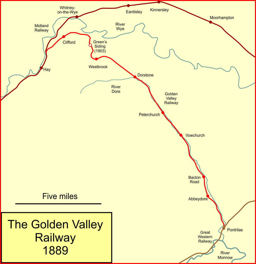
The Golden Valley Railway was a railway company which constructed a branch line from Pontrilas in Herefordshire, England, to Hay on Wye. Pontrilas was on the Great Western Railway main line between Newport and Hereford. The Golden Valley company opened the first part of its line from Pontrilas to Dorstone in 1881. It was constantly beset with shortage of money, but opened an extension to Hay in 1889. Its directors had grand ideas of extending further to Monmouth and forming part of a long distance trunk route. It issued misleading promotional material which secured significant investment from the public, but exposure of the falsehoods resulted in collapse. The line closed in 1898, and the company sold its undertaking to the Great Western Railway in 1899 for £11,000; the capital expended on the line had already amounted to £334,786. Passenger operation on the line ceased in 1941 and it closed completely in 1957. First railways to Hay Hay, later renamed Hay on Wye, was connect ... [...More Info...] [...Related Items...] OR: [Wikipedia] [Google] [Baidu] |
Abergavenny
Abergavenny (; cy, Y Fenni , archaically ''Abergafenni'' meaning "mouth of the River Gavenny") is a market town and community in Monmouthshire, Wales. Abergavenny is promoted as a ''Gateway to Wales''; it is approximately from the border with England and is located where the A40 trunk road and the A465 Heads of the Valleys road meet. Originally the site of a Roman fort, Gobannium, it became a medieval walled town within the Welsh Marches. The town contains the remains of a medieval stone castle built soon after the Norman conquest of Wales. Abergavenny is situated at the confluence of the River Usk and a tributary stream, the Gavenny. It is almost entirely surrounded by mountains and hills: the Blorenge (), the Sugar Loaf (), Ysgyryd Fawr (Great Skirrid), Ysgyryd Fach (Little Skirrid), Deri, Rholben and Mynydd Llanwenarth, known locally as " Llanwenarth Breast". Abergavenny provides access to the nearby Black Mountains and the Brecon Beacons National Park. The M ... [...More Info...] [...Related Items...] OR: [Wikipedia] [Google] [Baidu] |


.jpg)


