|
Point Escuminac
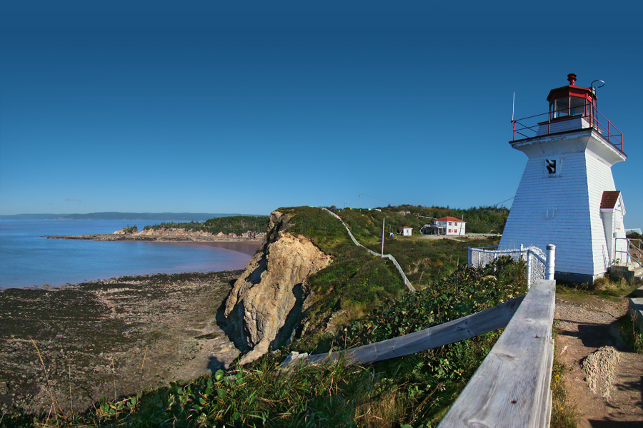
Point Escuminac is a cape located in eastern New Brunswick, Canada. Its geographic coordinates are 47º04'N, 64º48'W. It is the dividing point for delineating the western limits of the Northumberland Strait. It is located near the unincorporated fishing community of Escuminac, at the mouth of Miramichi Bay. See also *List of lighthouses in New Brunswick This is a list of lighthouses in New Brunswick. Lighthouses See also *List of lighthouses in Canada References External links New Brunswick Lighthouses''Lighthouses Friends''. Retrieved 18 February 2017 List of Lights, Buoys and Fog Signal ... References External links Point Escuminac, NBLighthouse Friends Aids to Navigation''Canadian Coast Guard'' Escuminac Landforms of Northumberland County, New Brunswick Lighthouses in New Brunswick {{NewBrunswick-geo-stub ... [...More Info...] [...Related Items...] OR: [Wikipedia] [Google] [Baidu] |
Miramichi Bay
Miramichi Bay is an estuary located on the west coast of the Gulf of St. Lawrence in New Brunswick, at the mouth of the Miramichi River. Miramichi Bay is separated into the "inner bay" and the "outer bay", with the division being a line of uninhabited barrier islands which are continually reshaped by ocean storms. The largest of these islands is the uninhabited Portage Island, which was broken in two during a violent storm in the 1950s. The islands provide some protection to the inner bay from ocean storms in the Gulf of St. Lawrence. Miramichi Bay was named by Jacques Cartier in 1534. The Inner Miramichi Bay, and the lower portions of its tributary rivers (including the Miramichi River), are parts of a drowned river valley system. Since deglaciation, sea level rise in Miramichi Bay has flooded the mouths of these rivers with saltwater. The flooded, meandering, ancient Miramichi river channel forms a navigable route through the Inner Bay for ocean-going ships entering the p ... [...More Info...] [...Related Items...] OR: [Wikipedia] [Google] [Baidu] |
New Brunswick
New Brunswick (french: Nouveau-Brunswick, , locally ) is one of the thirteen provinces and territories of Canada. It is one of the three Maritime provinces and one of the four Atlantic provinces. It is the only province with both English and French as its official languages. New Brunswick is bordered by Quebec to the north, Nova Scotia to the east, the Gulf of Saint Lawrence to the northeast, the Bay of Fundy to the southeast, and the U.S. state of Maine to the west. New Brunswick is about 83% forested and its northern half is occupied by the Appalachians. The province's climate is continental with snowy winters and temperate summers. New Brunswick has a surface area of and 775,610 inhabitants (2021 census). Atypically for Canada, only about half of the population lives in urban areas. New Brunswick's largest cities are Moncton and Saint John, while its capital is Fredericton. In 1969, New Brunswick passed the Official Languages Act which began recognizing French as an ... [...More Info...] [...Related Items...] OR: [Wikipedia] [Google] [Baidu] |
Canada
Canada is a country in North America. Its ten provinces and three territories extend from the Atlantic Ocean to the Pacific Ocean and northward into the Arctic Ocean, covering over , making it the world's second-largest country by total area. Its southern and western border with the United States, stretching , is the world's longest binational land border. Canada's capital is Ottawa, and its three largest metropolitan areas are Toronto, Montreal, and Vancouver. Indigenous peoples have continuously inhabited what is now Canada for thousands of years. Beginning in the 16th century, British and French expeditions explored and later settled along the Atlantic coast. As a consequence of various armed conflicts, France ceded nearly all of its colonies in North America in 1763. In 1867, with the union of three British North American colonies through Confederation, Canada was formed as a federal dominion of four provinces. This began an accretion of provinces an ... [...More Info...] [...Related Items...] OR: [Wikipedia] [Google] [Baidu] |
Northumberland Strait
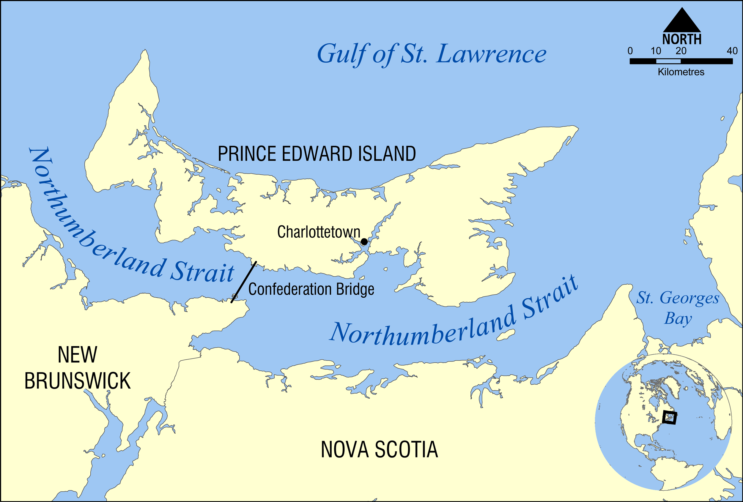
The Northumberland Strait (French: ''détroit de Northumberland'') is a strait in the southern part of the Gulf of Saint Lawrence in eastern Canada. The strait is formed by Prince Edward Island and the gulf's eastern, southern, and western shores. Boundaries The western boundary of the strait is delineated by a line running between North Cape, Prince Edward Island and Point Escuminac, New Brunswick while the eastern boundary is delineated by a line running between East Point, Prince Edward Island and Inverness, Nova Scotia. Hydrography The Northumberland Strait varies in depth between 17 and 65 metres, with the deepest waters at either end. The tidal patterns are complex; the eastern end has the usual two tides per day, with a tidal range of 1.2 to 1.8 metres, while the western end effectively has only one tide per day. The strait's shallow depths lend to warm water temperatures in summer months, with some areas reaching 25° C, or 77° F. Consequently, the strait is repo ... [...More Info...] [...Related Items...] OR: [Wikipedia] [Google] [Baidu] |
Escuminac, New Brunswick
Escuminac (2011 population: 212) is a rural community in Northumberland County, New Brunswick, Canada. The local service district of Escuminac takes its name from the community. Located on the south shore of Miramichi Bay, the community is several kilometres west of Point Escuminac, the southeastern limit of the bay. Canada's largest inshore fishing vessel harbour is home to the local fishing fleet. Industries include two fish processing & freezing plants and a boat building facility. One of Canada's important herring spawning grounds is located beside Point Escuminac. According to Joseph-Étienne Guinard, a missionary and Cree language specialist with some experience with the Mi'kmaq, the word means "here are small fruits". This perfectly describes the area as berries proliferate en masse in this low-lying flat area, and the first colonist were amazed at the amount of Ericaceae. Peat bogs and rare peat cliffs are situated in the vicinity of Point Escuminac, approximatel ... [...More Info...] [...Related Items...] OR: [Wikipedia] [Google] [Baidu] |
List Of Lighthouses In New Brunswick ...
This is a list of lighthouses in New Brunswick. Lighthouses See also *List of lighthouses in Canada References External links New Brunswick Lighthouses''Lighthouses Friends''. Retrieved 18 February 2017 List of Lights, Buoys and Fog Signals''Canadian Coast Guard''. Retrieved 18 February 2017 {{Lighthouses of Canada Newfoundland and Labrador Lighthouses A lighthouse is a tower, building, or other type of physical structure designed to emit light from a system of lamps and lenses and to serve as a beacon for navigational aid, for maritime pilots at sea or on inland waterways. Lighthouses mark ... [...More Info...] [...Related Items...] OR: [Wikipedia] [Google] [Baidu] |
20131003T174909Z TY12964-PointEscuminacNB , the New Jersey Transit bus
{{numberdis ...
131 may refer to: *131 (number) *AD 131 *131 BC *131 (album), the album by Emarosa *131 (MBTA bus), the Massachusetts Bay Transportation Authority bus. For the MBTA bus, see 131 (MBTA bus). *131 (New Jersey bus) 131 may refer to: * 131 (number) *AD 131 *131 BC * 131 (album), the album by Emarosa *131 (MBTA bus) The Massachusetts Bay Transportation Authority bus division operates bus routes in the Boston, Massachusetts metropolitan area. All routes conn ... [...More Info...] [...Related Items...] OR: [Wikipedia] [Google] [Baidu] |
Headlands Of New Brunswick
A headland, also known as a head, is a coastal landform, a point of land usually high and often with a sheer drop, that extends into a body of water. It is a type of promontory. A headland of considerable size often is called a cape.Whittow, John (1984). ''Dictionary of Physical Geography''. London: Penguin, 1984, pp. 80, 246. . Headlands are characterised by high, breaking waves, rocky shores, intense erosion, and steep sea cliff. Headlands and bays are often found on the same coastline. A bay is flanked by land on three sides, whereas a headland is flanked by water on three sides. Headlands and bays form on discordant coastlines, where bands of rock of alternating resistance run perpendicular to the coast. Bays form when weak (less resistant) rocks (such as sands and clays) are eroded, leaving bands of stronger (more resistant) rocks (such as chalk, limestone, and granite) forming a headland, or peninsula. Through the deposition of sediment within the bay and the erosion of ... [...More Info...] [...Related Items...] OR: [Wikipedia] [Google] [Baidu] |
Landforms Of Northumberland County, New Brunswick
A landform is a natural or anthropogenic land feature on the solid surface of the Earth or other planetary body. Landforms together make up a given terrain, and their arrangement in the landscape is known as topography. Landforms include hills, mountains, canyons, and valleys, as well as shoreline features such as bays, peninsulas, and seas, including submerged features such as mid-ocean ridges, volcanoes, and the great ocean basins. Physical characteristics Landforms are categorized by characteristic physical attributes such as elevation, slope, orientation, stratification, rock exposure and soil type. Gross physical features or landforms include intuitive elements such as berms, mounds, hills, ridges, cliffs, valleys, rivers, peninsulas, volcanoes, and numerous other structural and size-scaled (e.g. ponds vs. lakes, hills vs. mountains) elements including various kinds of inland and oceanic waterbodies and sub-surface features. Mountains, hills, plateaux, and plains are the fou ... [...More Info...] [...Related Items...] OR: [Wikipedia] [Google] [Baidu] |


.jpg)