|
Poeketi Airstrip
Poeketi Airstrip is an airstrip serving Poeketi, Suriname. Charter airlines and destinations Charter Airlines serving this airport are: See also * * * List of airports in Suriname * Transport in Suriname The Republic of Suriname ( nl, Republiek Suriname) has a number of forms of transport. Transportation emissions are an increasing part of Suriname's contributions to climate change, as part of the Nationally Determined Contributions for the Par ... References External linksOpenStreetMap - Poeketi Airports in Suriname {{Suriname-airport-stub ... [...More Info...] [...Related Items...] OR: [Wikipedia] [Google] [Baidu] |
Luchtvaartdienst Suriname
The Luchtvaartdienst Suriname is the Civil Aviation Department of the Suriname Ministry of Transport, Communication and Tourism. It is responsible for the regulation of all aviation activities in the country, and ensures that all activities are carried out in compliance with international standards. It is a member of the International Civil Aviation Organization The International Civil Aviation Organization (ICAO, ) is a specialized agency of the United Nations that coordinates the principles and techniques of international air navigation, and fosters the planning and development of international sc ... (ICAO). In April 2010, John Veira, the head of Luchtvaartdienst Suriname, was killed in his home by gunmen. Dutch language Airports and Airst ...
|
Poeketi
Poeketi or Puketi is a Ndyuka village in Suriname. It lies in Sipaliwini District. On May 15, 2010, a plane crashed near Poeketi. Energy Between 1981 and 1987, electricity was provided by the Puketi hydroelectric power plant. After this power plant stopped working during the Surinamese Interior War there have been attempts to rehabilitate the facility, but after a university delegation in 2003 and 2004 investigated the possibilities for hydroelectric power in the region, the Ministry for Regional Development decided to instead fund the construction of a larger hydroelectric power plant at the Gran Olo rapids nearby. This power plant is still to be completed. Transportation By air Poeketi is served by Poeketi Airstrip, offering Caricom Airways scheduled services from Paramaribo Paramaribo (; ; nicknamed Par'bo) is the capital and largest city of Suriname, located on the banks of the Suriname River in the Paramaribo District. Paramaribo has a population of roughly ... [...More Info...] [...Related Items...] OR: [Wikipedia] [Google] [Baidu] |
Suriname
Suriname (; srn, Sranankondre or ), officially the Republic of Suriname ( nl, Republiek Suriname , srn, Ripolik fu Sranan), is a country on the northeastern Atlantic coast of South America. It is bordered by the Atlantic Ocean to the north, French Guiana to the east, Guyana to the west, and Brazil to the south. At just under , it is the smallest sovereign state in South America. It has a population of approximately , dominated by descendants from the slaves and labourers brought in from Africa and Asia by the Dutch Empire and Republic. Most of the people live by the country's (north) coast, in and around its capital and largest city, Paramaribo. It is also List of countries and dependencies by population density, one of the least densely populated countries on Earth. Situated slightly north of the equator, Suriname is a tropical country dominated by rainforests. Its extensive tree cover is vital to the country's efforts to Climate change in Suriname, mitigate climate ch ... [...More Info...] [...Related Items...] OR: [Wikipedia] [Google] [Baidu] |
Airstrip
An aerodrome (Commonwealth English) or airdrome (American English) is a location from which aircraft flight operations take place, regardless of whether they involve air cargo, passengers, or neither, and regardless of whether it is for public or private use. Aerodromes include small general aviation airfields, large commercial airports, and military air bases. The term ''airport'' may imply a certain stature (having satisfied certain certification criteria or regulatory requirements) that not all aerodromes may have achieved. That means that all airports are aerodromes, but not all aerodromes are airports. Usage of the term "aerodrome" remains more common in Ireland and Commonwealth nations, and is conversely almost unknown in American English, where the term "airport" is applied almost exclusively. A water aerodrome is an area of open water used regularly by seaplanes, floatplanes or amphibious aircraft for landing and taking off. In formal terminology, as defined by th ... [...More Info...] [...Related Items...] OR: [Wikipedia] [Google] [Baidu] |
Blue Wing Airlines
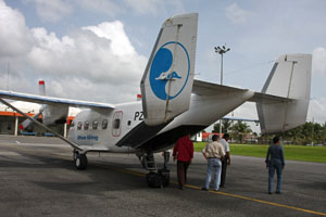
Blue Wing Airlines n.v. is an airline with its head office on the grounds of Zorg en Hoop Airport in Paramaribo, Suriname.Eight feared dead in Suriname air crash " ''''. 16 May 2010. Retrieved on 17 May 2010. The airline started operations in January 2002 and operates charter and scheduled services from to destinations in the interior of , |
Zorg En Hoop Airport
Zorg en Hoop Airport is an airport serving general aviation in the city of Paramaribo, Suriname. It is west of the Suriname River, between the city quarters of Zorg en Hoop and Flora. The runway length includes a displaced threshold on Runway 11. The airport is suitable for charters and regular services with smaller aircraft, and for helicopter flights. Connection is maintained from the airport for several smaller airports in the interior of Suriname, and for charter flights to the Caribbean. The only regular international service is to Georgetown, Guyana Georgetown is the capital (political), capital and largest city of Guyana. It is situated in Demerara-Mahaica, region 4, on the Atlantic Ocean coast, at the mouth of the Demerara River. It is nicknamed the "Garden City of the Caribbean." It is t ..., with flights operated by Trans Guyana Airways and Gum Air with smaller propeller aircraft. Airlines operating jet aircraft serve Paramaribo via Johan Adolf Pengel Internation ... [...More Info...] [...Related Items...] OR: [Wikipedia] [Google] [Baidu] |
Gum Air
Gum Air is a Surinamese airline based at Zorg en Hoop Airport in Paramaribo, Suriname. Gum Air cooperates with Trans Guyana Airways to provide daily flights between Zorg en Hoop Airport, Zorg en Hoop Airport (ORG) in Paramaribo, Suriname and Ogle Airport, Ogle Airport (OGL) in Georgetown, Guyana. History Gum Air was founded in 1971 by six brothers of the Gummels family. The company they started in March 1964 was agriculture airspray company named Surinam Sky Farmers and Gum Air its offspring focused more on domestic flights and regional charters. Whereas Surinam Sky Farmers has its base in the rice district of Nickerie District, Nickerie at the Wageningen Airstrip together with Overeem Air Service maintaining Grumman Ag Cat aircraft, Gum Air has set up its domestic airline at the Zorg en Hoop Airport in the city. Current operation Gum Air has its base at Zorg en Hoop airfield in the capital city Paramaribo and now mainly flies with single engine Cessna airplanes and twin-engin ... [...More Info...] [...Related Items...] OR: [Wikipedia] [Google] [Baidu] |
List Of Airports In Suriname
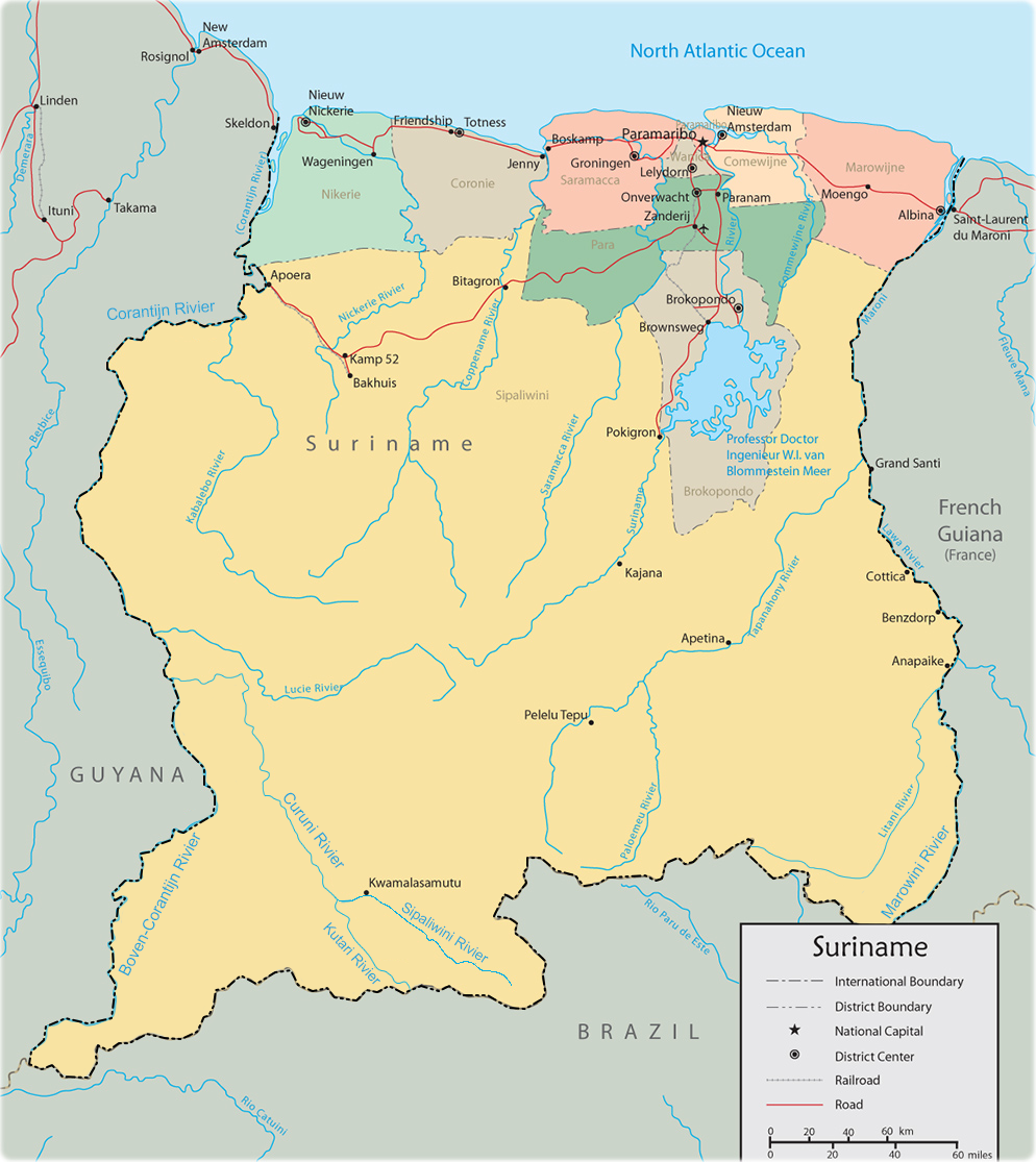
This is a list of airports in Suriname, sorted by location. Suriname, officially the Republic of Suriname, is a country in northern South America. It is situated between French Guiana to the east and Guyana to the west. The southern border is shared with Brazil and the northern border is the Atlantic coast. Suriname is the smallest sovereign state in terms of area and population in South America. The country is the only Dutch-speaking region in the Western Hemisphere that is not a part of the Kingdom of the Netherlands. __TOC__ Airports Airport names shown in bold indicate the airport has scheduled service on commercial airlines. Airports with unverified coordinates: Map See also * Transport in Suriname * Operation Grasshopper * List of airports by ICAO code: S#SM - Suriname * Wikipedia: WikiProject Aviation/Airline destination lists: South America#Suriname References Civil Aviation Department of Suriname* * - includes IATA codes World Aero Data: Airports ... [...More Info...] [...Related Items...] OR: [Wikipedia] [Google] [Baidu] |
Transport In Suriname
The Republic of Suriname ( nl, Republiek Suriname) has a number of forms of transport. Transportation emissions are an increasing part of Suriname's contributions to climate change, as part of the Nationally Determined Contributions for the Paris Agreement, Suriname has committed to emissions controls for vehicles and increased public transit investment. Railways *Railways, total: 166 km single track. **standard gauge: 80 km gauge in West-Suriname, but not in use. This stretch was constructed as part of the West Suriname Plan. **narrow gauge: 86 km gauge Lawa Railway from Onverwacht to Sarakreek, currently not in use. In 2014, a plan had been announced to reopen the line between Onverwacht and Paramaribo Central Station. The intention was for the line to be extended onto Paramaribo Adolf Pengel Airport, but as of May 2020, the project has not started. Rail links with adjacent countries * None Highways Afobakaweg The Afobakaweg is a paved 2-lane road connect ... [...More Info...] [...Related Items...] OR: [Wikipedia] [Google] [Baidu] |


.jpg)

.jpg)