|
Plynlimon And Hafan Tramway
The Plynlimon and Hafan Tramway was a gauge narrow gauge railway in Cardiganshire (now Ceredigion) in Mid Wales. It ran from (later renamed ''Llandre station'') on the Cambrian Line, through the village of Tal-y-bont, Ceredigion, Tal-y-bont and the valley of the Afon Leri, into the foothills of Plynlimon Fawr. It was built to serve the Metal mining in Wales, lead mines at Bwlch Glas and stone quarries around Hafan and opened in 1897, closing just two years later. The line was a little over long and, despite running a short-lived passenger service, it served no communities of more than 100 people. History Background: before 1895 Mining of minerals in the hills east of Tal-y-bont, Ceredigion, Talybont in Mid-Wales dates back as far as 1698, with the Hafan Mine, which principally produced lead ore, but also copper ore and zinc.Wade, p. 16 In 1890, Captain John Davis of Talybont and Thomas Molyneux, an industrialist of Earlestown in Lancashire, joined forces to exploit mine ... [...More Info...] [...Related Items...] OR: [Wikipedia] [Google] [Baidu] |
Wales
Wales ( cy, Cymru ) is a Countries of the United Kingdom, country that is part of the United Kingdom. It is bordered by England to the Wales–England border, east, the Irish Sea to the north and west, the Celtic Sea to the south west and the Bristol Channel to the south. It had a population in 2021 of 3,107,500 and has a total area of . Wales has over of coastline and is largely mountainous with its higher peaks in the north and central areas, including Snowdon (), its highest summit. The country lies within the Temperateness, north temperate zone and has a changeable, maritime climate. The capital and largest city is Cardiff. Welsh national identity emerged among the Celtic Britons after the Roman withdrawal from Britain in the 5th century, and Wales was formed as a Kingdom of Wales, kingdom under Gruffydd ap Llywelyn in 1055. Wales is regarded as one of the Celtic nations. The Conquest of Wales by Edward I, conquest of Wales by Edward I of England was completed by 1283, th ... [...More Info...] [...Related Items...] OR: [Wikipedia] [Google] [Baidu] |
Earlestown
Earlestown is a town and electoral ward in the Metropolitan Borough of St Helens in Merseyside, England. It forms the western part of the wider Newton-le-Willows urban area. At the 2011 Census the ward population was 10,830. History Earlestown is named after Sir Hardman Earle (11 July 1792 – 25 January 1877) a slave owner whose family was steeped in the slave trade. He was the Chairman of the London and North Western Railway. In July 1831, the Warrington and Newton Railway was opened, less than 6 months after the Liverpool and Manchester railway began service. A railway station was built at the junction of the two railways, a mile west of the town of Newton in Makerfield, now Newton-le-Willows and was given the name Newton Junction. A locomotive and wagon works was built just west of the station and a model town was constructed for its workers. In 1837, the name of the station was changed to Earlestown. Locomotive building was concentrated in another area within Newton-le-W ... [...More Info...] [...Related Items...] OR: [Wikipedia] [Google] [Baidu] |
Vale Of Rheidol Railway
The Vale of Rheidol Railway ( cy, Rheilffordd Cwm Rheidol) is a narrow gauge heritage railway in Ceredigion, Wales, between Aberystwyth and Devil's Bridge; a journey of . It opened in 1902, and from the withdrawal of main line steam on British Rail in 1968 until privatisation in 1989, it was the sole steam-operated line on the 1948 nationalised British Rail network. It was one of the first parts of British Rail to be privatised. Unlike most other preserved railways in the United Kingdom, the Vale of Rheidol Railway did not have a period of closure between its being part of the national rail system and becoming a heritage railway, and so has operated a continuous service for residents and tourists. History Vale of Rheidol Light Railway Company A narrow-gauge railway in the area of Aberystwyth was first proposed after the initial route planned for the Manchester and Milford Railway, from Llanidloes to Aberystwyth via Devil's Bridge, was altered, and then abandoned, before co ... [...More Info...] [...Related Items...] OR: [Wikipedia] [Google] [Baidu] |
James Szlumper
Sir James Weeks Szlumper JP DL (29 January 1834 – 27 October 1926) was an English civil engineer. He was Chief Engineer on a number of key railway engineering projects in the Victorian era. Biography Szlumper was born in Westminster to Albert Szlumper, a Polish tailor, and his first wife, Eliza. He began his career with a London firm of engineers, and in 1853 was appointed surveyor to the county of Cardiganshire, a position in which he held for 25 years. In this position, he was often in correspondence and conflict with the local landowners, particularly John Waddingham, the then owner of thHafod Estate His younger half-brother Alfred Weeks Szlumper (1858–1934) was also a railway engineer. Railway engineer Szlumper had a dual career as a railway engineer, laying out some of key lines linking the major routes to the wider countryside of Wales and the West. He started his railway career engineering parts of the London Underground in employment in London. When he took the ... [...More Info...] [...Related Items...] OR: [Wikipedia] [Google] [Baidu] |
Gogerddan
__NOTOC__ Gogerddan, or in English, Gogarthen, was an estate near to Trefeurig and the most important in what was then the county of Cardiganshire, Wales. Owned since at least the fifteenth century by the Pryse family, the main house, called Plas Gogerddan, still stands and is a Grade II listed building. The estate became especially wealthy from the seventeenth century on the profits from lead mining, which is when the house was constructed. The house was significantly altered in the 1860s and was sold by Sir Pryse Loveden Saunders-Pryse to University College of Wales in 1949. Gogerddan provisionally held the high temperature record for Wales – 35.3°C, which was recorded on 18 July 2022. It replaced the previous record holder Hawarden which held the record for almost 32 years. This record was short-lived, however, as by the end of the same day, Hawarden recorded a temperature of 37.1°C. See also * Pryse baronets There have been two baronetcies created for members of th ... [...More Info...] [...Related Items...] OR: [Wikipedia] [Google] [Baidu] |
Llandre Railway Station
Llandre, or Llanfihangel Genau'r Glyn, is a village in Ceredigion, Wales. It lies 5 miles north of Aberystwyth in the north-west of the county, on the road from Rhydypennau to Borth. To the north of the community lies the village of Dôl-y-bont. The community is called Geneu'r Glyn. Toponymy The traditional placename of the village was Llanfihangel Genau'r Glyn ( en, St Michaels at the Mouth of the Valley), which derives from its location in the old cwmwd of Genau'r Glyn, part of the cantref of Penweddig. Before that, the name was Llanfihangel Castell Gwallter. The name changed to Llanfihangel Genau'r Glyn in the 16th century. When the railway station opened in 1864 the nameboards read simply "Llanfihangel", but in 1916, at the request of Cynnull Mawr Parish Council "as Llanfihangel is a very common place name in Wales and much confusion is causing considerable inconvenience", the name was changed to Llandre ( en, Churchtown). The old name of Llanfihangel Genau'r Glyn sti ... [...More Info...] [...Related Items...] OR: [Wikipedia] [Google] [Baidu] |
Clarach Bay
Clarach Bay is a small bay on the coast of Ceredigion, Wales, to the north of Aberystwyth, where the Afon Clarach The Afon Clarach ( en, River Clarach) is a small river discharging into Cardigan Bay north of Aberystwyth. It flows through a largely agricultural and forested landscape except in its lowest reaches where its banks are crowded with holiday devel ... flows into the sea. It has given homes to the two main caravan parks of Clarach Bay Holiday Village and Glan Y Mor Leisure Park plus a few smaller ones for holiday makers, the coastal paths runs from Aberystwyth to Borth via Clarach. External links Illustrated description [...More Info...] [...Related Items...] OR: [Wikipedia] [Google] [Baidu] |
Aberystwyth
Aberystwyth () is a university and seaside town as well as a community in Ceredigion, Wales. Located in the historic county of Cardiganshire, means "the mouth of the Ystwyth". Aberystwyth University has been a major educational location in Wales since the establishment of University College Wales in 1872. The town is situated on Cardigan Bay on the west coast of Wales, near the confluence of the River Ystwyth and Afon Rheidol. Following the reconstruction of the harbour, the Ystwyth skirts the town. The Rheidol passes through the town. The seafront, with a pier, stretches from Constitution Hill at the north end of the Promenade to the harbour at the south. The beach is divided by the castle. The town is divided into five areas: Aberystwyth Town; Llanbadarn Fawr; Waunfawr; Llanbadarn; Trefechan; and the most populous, Penparcau. In 2011 the population of the town was 13,040. This rises to nearly 19,000 for the larger conurbation of Aberystwyth and Llanbadarn Fawr. Th ... [...More Info...] [...Related Items...] OR: [Wikipedia] [Google] [Baidu] |
Machynlleth
Machynlleth () is a market town, community and electoral ward in Powys, Wales and within the historic boundaries of Montgomeryshire. It is in the Dyfi Valley at the intersection of the A487 and the A489 roads. At the 2001 Census it had a population of 2,147, rising to 2,235 in 2011. It is sometimes referred to colloquially as ''Mach''. Machynlleth was the seat of Owain Glyndŵr's Welsh Parliament in 1404,''The Welsh Academy Encyclopaedia of Wales''. John Davies, Nigel Jenkins, Menna Baines and Peredur Lynch (2008) pg527 and as such claims to be the "ancient capital of Wales". However, it has never held any official recognition as a capital. It applied for city status in 2000 and 2002, but was unsuccessful. It is twinned with Belleville, Michigan. Machynlleth hosted the National Eisteddfod in 1937 and 1981. Etymology The etymology of the name Machynlleth derives from "ma-" ield, plainand "Cynllaith". History There is a long history of human activity in the Machynllet ... [...More Info...] [...Related Items...] OR: [Wikipedia] [Google] [Baidu] |
Cambrian Railways
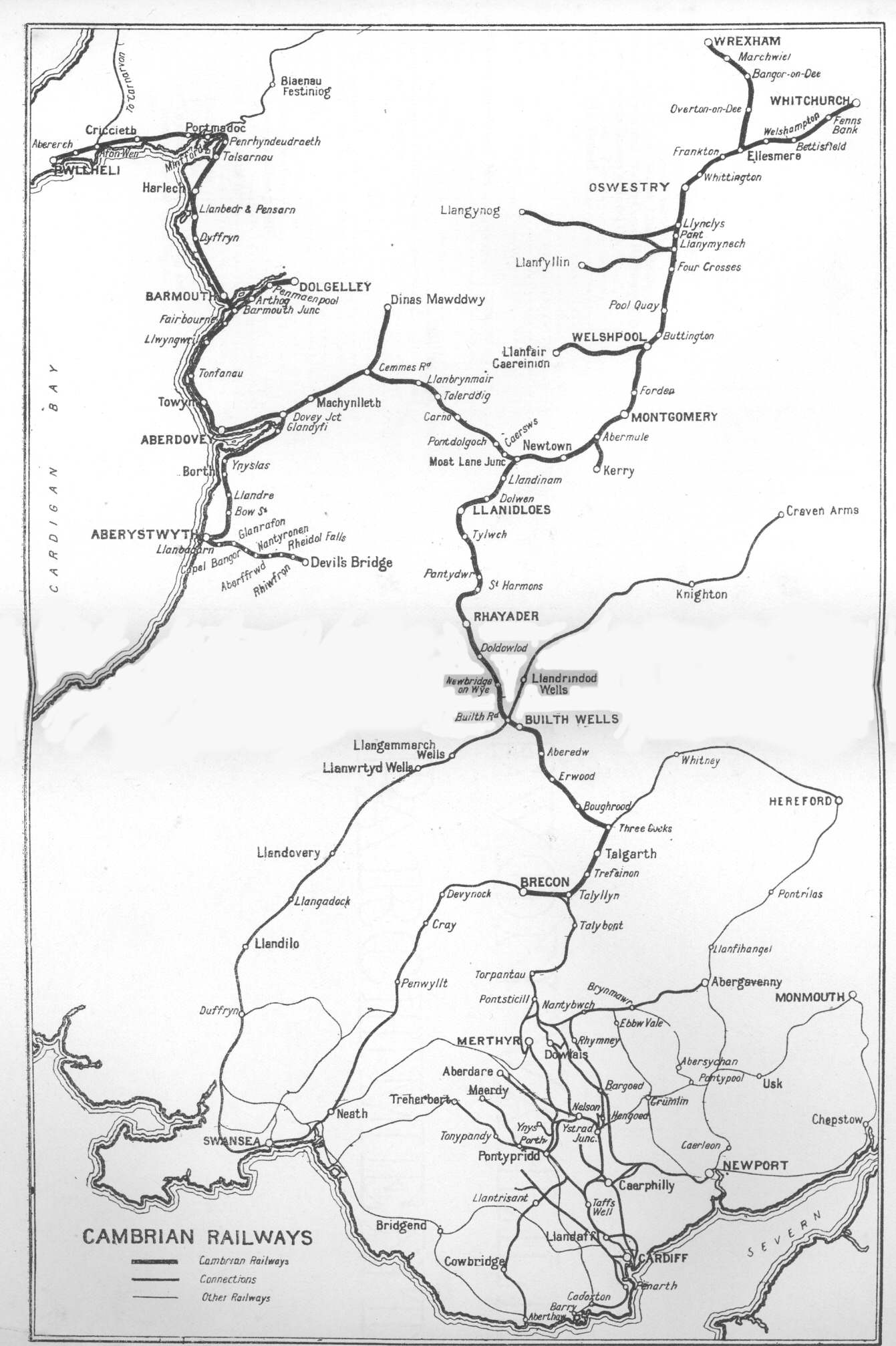
The Cambrian Railways owned of track over a large area of mid Wales. The system was an amalgamation of a number of railways that were incorporated in 1864, 1865 and 1904. The Cambrian connected with two larger railways with connections to the northwest of England via the London and North Western Railway, and the Great Western Railway for connections between London and Wales. The Cambrian Railways amalgamated with the Great Western Railway on 1 January 1922 as a result of the Railways Act 1921. The name is continued today in the route known as the Cambrian Line. History Creation of the Cambrian Railways: 1864 The Cambrian Railways Company was created on 25 July 1864 when the Cambrian Railways Act of Parliament received Royal Assent. The company was formed by amalgamating most of the railway companies in mid Wales: the Oswestry and Newtown Railway, the Llanidloes and Newtown Railway, the Newtown and Machynlleth Railway and the Oswestry, Ellesmere and Whitchurch Railway. ... [...More Info...] [...Related Items...] OR: [Wikipedia] [Google] [Baidu] |
Cors Fochno
Cors Fochno is a raised peat bog near the village of Borth, in the county of Ceredigion, Wales. Lying on the south side of the Dyfi estuary, it forms a component part of the Dyfi National Nature Reserve. It was designated a UNESCO (United Nations Educational, Scientific and Cultural Organization) biosphere reserve in 1976, and is the only such reserve in Wales. Joint Nature Conservation Committee (JNCC) 20 March 2008 A significant portion of the former complex was taken for agriculture; the surviving core area supports the largest expanse of primary near-natural in an [...More Info...] [...Related Items...] OR: [Wikipedia] [Google] [Baidu] |


.jpg)


