|
Pico Do Castelo
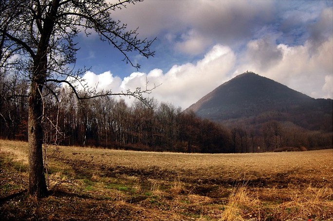
Pico do Castelo () is a high volcano-shaped peak on Porto Santo Island. The peak is covered with conifer Conifers are a group of conifer cone, cone-bearing Spermatophyte, seed plants, a subset of gymnosperms. Scientifically, they make up the phylum, division Pinophyta (), also known as Coniferophyta () or Coniferae. The division contains a single ...s and has a panoramic terrace and a picnic spot. On the top, there is a bust in homage to Schiappa de Azevedo, who contributed strongly to the afforestation of the hill, which was once more deserted, and there are also ruins of a 16th century fortress, symbol of the defense of the population against the continued pirate attacks on the island, during troubled centuries. References {{Reflist Geography of Madeira Mountains of Portugal ... [...More Info...] [...Related Items...] OR: [Wikipedia] [Google] [Baidu] |
Vila Baleira here, in 1479.
{{Madeira-geo-stub ...
Vila Baleira is the main city in the municipality of Porto Santo, located on Porto Santo Island, Madeira, Portugal. It was made a city on 7 August 1996. References Porto Santo Island Populated places in Madeira Trivia Christopher Columbus is thought to have married his wife and Portuguese Nobelwoman Filipa Moniz Perestrelo Filipa Moniz Perestrelo (c. 1455 – between 1479 and 1484) was a Portuguese noblewoman from Porto Santo Island, in Madeira, Portugal. She was the wife of Christopher Columbus, married in 1479 in Vila Baleira on the island. History Filipa ... [...More Info...] [...Related Items...] OR: [Wikipedia] [Google] [Baidu] |
Porto Santo Island
Porto Santo Island () is a Portuguese island northeast of Madeira Island in the North Atlantic Ocean; it is the northernmost and easternmost island of the archipelago of Madeira, located in the Atlantic Ocean west of Europe and Africa. The municipality of Porto Santo occupies the entire island and small neighboring islands. It was elevated to city status on 6 August 1996. The sole parish of the municipality is also named Porto Santo. The population in 2011 was 5,483, in an area of 42.59 km². The main settlement on the island is Vila Baleira. History It appears that some knowledge of Atlantic islands, such as Madeira, existed before the discovery and settlement of these lands, as the islands appear on maps as early as 1339. From a portolan dating to 1351, and preserved in Florence, Italy, it would appear that the islands of Madeira had been discovered long before being claimed by the Portuguese expedition of 1418. In ''Libro del Conocimiento'' (1348–1349), a Castilian ... [...More Info...] [...Related Items...] OR: [Wikipedia] [Google] [Baidu] |
Madeira
) , anthem = ( en, "Anthem of the Autonomous Region of Madeira") , song_type = Regional anthem , image_map=EU-Portugal_with_Madeira_circled.svg , map_alt=Location of Madeira , map_caption=Location of Madeira , subdivision_type=Sovereign state , subdivision_name=Portugal , established_title=Discovery , established_date=1418-1419 , established_title2=Settlement , established_date2=c. 1425 , established_title3=Autonomous status , established_date3=30 April 1976 , named_for = en, wood ( pt, madeira) , official_languages=Portuguese , demonym= en, Madeiran ( pt, Madeirense) , capital = Funchal , government_type=Autonomous Region , leader_title1=Representative of the Republic , leader_name1=Irineu Barreto , leader_title2=President of the Regional Government of Madeira , leader_name2=Miguel Albuquerque , leader_title3=President of the Legislative Assembly , leader_name3=José Manuel Rodrigues , legislature= Legislative Assembly , national_representation=National ... [...More Info...] [...Related Items...] OR: [Wikipedia] [Google] [Baidu] |
Conical Hill
A conical hill (also cone or conical mountain) is a landform with a distinctly conical shape. It is usually isolated or rises above other surrounding foothills, and is often of volcanic origin. Conical hills or mountains occur in different shapes and are not necessarily geometrically-shaped cones; some are more tower-shaped or have an asymmetric curve on one side of the hill. Typically, however, they have a circular base and smooth sides with a gradient of up to 30°. Such conical mountains are found in all volcanically-formed areas of the world such as the Bohemian Central Uplands in the Czech Republic, the Rhön in Germany or the Massif Central in France. Term The conical hill as a geomorphological term first appeared in the German language, as ''Kegelberg'', coined by Goethe and geologists of his era. From their natural appearance these were mostly basaltic or phonolitic landforms in the shape of a mathematical cone, hence why the term came to be used in the early geolo ... [...More Info...] [...Related Items...] OR: [Wikipedia] [Google] [Baidu] |
Conifer
Conifers are a group of conifer cone, cone-bearing Spermatophyte, seed plants, a subset of gymnosperms. Scientifically, they make up the phylum, division Pinophyta (), also known as Coniferophyta () or Coniferae. The division contains a single extant class (biology), class, Pinopsida. All Neontology, extant conifers are perennial plant, perennial woody plants with secondary growth. The great majority are trees, though a few are shrubs. Examples include Cedrus, cedars, Pseudotsuga, Douglas-firs, Cupressaceae, cypresses, firs, junipers, Agathis, kauri, larches, pines, Tsuga, hemlocks, Sequoioideae, redwoods, spruces, and Taxaceae, yews.Campbell, Reece, "Phylum Coniferophyta". Biology. 7th. 2005. Print. P. 595 As of 1998, the division Pinophyta was estimated to contain eight families, 68 genera, and 629 living species. Although the total number of species is relatively small, conifers are ecology, ecologically important. They are the dominant plants over large areas of land, most ... [...More Info...] [...Related Items...] OR: [Wikipedia] [Google] [Baidu] |
Geography Of Madeira
) , anthem = ( en, "Anthem of the Autonomous Region of Madeira") , song_type = Regional anthem , image_map=EU-Portugal_with_Madeira_circled.svg , map_alt=Location of Madeira , map_caption=Location of Madeira , subdivision_type=Sovereign state , subdivision_name=Portugal , established_title=Discovery , established_date=1418-1419 , established_title2=Settlement , established_date2=c. 1425 , established_title3=Autonomous status , established_date3=30 April 1976 , named_for = en, wood ( pt, madeira) , official_languages=Portuguese , demonym= en, Madeiran ( pt, Madeirense) , capital = Funchal , government_type=Autonomous Region , leader_title1=Representative of the Republic , leader_name1=Irineu Barreto , leader_title2=President of the Regional Government of Madeira , leader_name2=Miguel Albuquerque , leader_title3=President of the Legislative Assembly , leader_name3=José Manuel Rodrigues , legislature= Legislative Assembly , national_representation=National ... [...More Info...] [...Related Items...] OR: [Wikipedia] [Google] [Baidu] |
