|
Petrus Plancius
Petrus Plancius (; 1552 – 15 May 1622) was a Dutch-Flemish astronomer, cartographer and clergyman. He was born as Pieter Platevoet in Dranouter, now in Heuvelland, West Flanders. He studied theology in Germany and England. At the age of 24 he became a minister in the Dutch Reformed Church. Plancius fled from Brussels to Amsterdam to avoid religious prosecution by the Inquisition after the city fell into Spanish hands in 1585. In Amsterdam he became interested in navigation and cartography and, having access to nautical charts recently brought from Portugal, he was soon recognized as an expert on safe maritime routes to India and the nearby "spice islands". This enabled colonies and port trade in both, including what would become the Dutch East Indies, named after the Dutch East India Company set up in 1602. He saw strong potential in the little-mapped Arctic Sea and strongly believed in the idea of a Northeast Passage until the failure of Willem Barentsz's third voyage in 15 ... [...More Info...] [...Related Items...] OR: [Wikipedia] [Google] [Baidu] |
Dutch People
The Dutch (Dutch: ) are an ethnic group and nation native to the Netherlands. They share a common history and culture and speak the Dutch language. Dutch people and their descendants are found in migrant communities worldwide, notably in Aruba, Suriname, Guyana, Curaçao, Argentina, Brazil, Canada,Based on Statistics Canada, Canada 2001 Censusbr>Linkto Canadian statistics. Australia, South Africa, New Zealand and the United States.According tFactfinder.census.gov The Low Countries were situated around the border of France and the Holy Roman Empire, forming a part of their respective peripheries and the various territories of which they consisted had become virtually autonomous by the 13th century. Under the Habsburgs, the Netherlands were organised into a single administrative unit, and in the 16th and 17th centuries the Northern Netherlands gained independence from Spain as the Dutch Republic. The high degree of urbanization characteristic of Dutch society was attained at a ... [...More Info...] [...Related Items...] OR: [Wikipedia] [Google] [Baidu] |
Dutch East Indies
The Dutch East Indies, also known as the Netherlands East Indies ( nl, Nederlands(ch)-Indië; ), was a Dutch colony consisting of what is now Indonesia. It was formed from the nationalised trading posts of the Dutch East India Company, which came under the administration of the Dutch government in 1800. During the 19th century, the Dutch possessions and hegemony expanded, reaching the greatest territorial extent in the early 20th century. The Dutch East Indies was one of the most valuable colonies under European rule, and contributed to Dutch global prominence in spice and cash crop trade in the 19th to early 20th centuries. The colonial social order was based on rigid racial and social structures with a Dutch elite living separate from but linked to their native subjects. The term ''Indonesia'' came into use for the geographical location after 1880. In the early 20th century, local intellectuals began developing the concept of Indonesia as a nation state, and set the stage ... [...More Info...] [...Related Items...] OR: [Wikipedia] [Google] [Baidu] |
New World
The term ''New World'' is often used to mean the majority of Earth's Western Hemisphere, specifically the Americas."America." ''The Oxford Companion to the English Language'' (). McArthur, Tom, ed., 1992. New York: Oxford University Press, p. 33: "[16c: from the feminine of ''Americus'', the Latinized first name of the explorer Amerigo Vespucci (1454–1512). The name ''America'' first appeared on a map in 1507 by the German cartographer Martin Waldseemüller, referring to the area now called Brazil]. Since the 16c, a name of the western hemisphere, often in the plural ''Americas'' and more or less synonymous with ''the New World''. Since the 18c, a name of the United States of America. The second sense is now primary in English: ... However, the term is open to uncertainties: ..." The term gained prominence in the early 16th century, during Europe's Age of Discovery, shortly after the Italian explorer Amerigo Vespucci concluded that America (now often called ''the Am ... [...More Info...] [...Related Items...] OR: [Wikipedia] [Google] [Baidu] |
Henry Hudson
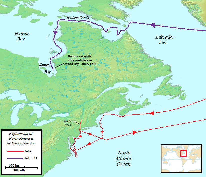
Henry Hudson ( 1565 – disappeared 23 June 1611) was an English sea explorer and navigator during the early 17th century, best known for his explorations of present-day Canada and parts of the northeastern United States. In 1607 and 1608, Hudson made two attempts on behalf of English merchants to find a rumoured Northeast Passage to Cathay via a route above the Arctic Circle. In 1609, he landed in North America on behalf of the Dutch East India Company and explored the region around the modern New York metropolitan area. Looking for a Northwest Passage to Asia on his ship ''Halve Maen'' ("Half Moon"), he sailed up the Hudson River, which was later named after him, and thereby laid the foundation for Dutch colonization of the region. On his final expedition, while still searching for the Northwest Passage, Hudson became the first European to see Hudson Strait and the immense Hudson Bay. In 1611, after wintering on the shore of James Bay, Hudson wanted to press on to t ... [...More Info...] [...Related Items...] OR: [Wikipedia] [Google] [Baidu] |
Mercator Projection
The Mercator projection () is a cylindrical map projection presented by Flemish geographer and cartographer Gerardus Mercator in 1569. It became the standard map projection for navigation because it is unique in representing north as up and south as down everywhere while preserving local directions and shapes. The map is thereby conformal. As a side effect, the Mercator projection inflates the size of objects away from the equator. This inflation is very small near the equator but accelerates with increasing latitude to become infinite at the poles. As a result, landmasses such as Greenland, Antarctica and Russia appear far larger than they actually are relative to landmasses near the equator, such as Central Africa. History There is some controversy over the origins of the Mercator. German polymath Erhard Etzlaub engraved miniature "compass maps" (about 10×8 cm) of Europe and parts of Africa that spanned latitudes 0°–67° to allow adjustment of his portable pocket-s ... [...More Info...] [...Related Items...] OR: [Wikipedia] [Google] [Baidu] |
Longitude
Longitude (, ) is a geographic coordinate that specifies the east–west position of a point on the surface of the Earth, or another celestial body. It is an angular measurement, usually expressed in degrees and denoted by the Greek letter lambda (λ). Meridians are semicircular lines running from pole to pole that connect points with the same longitude. The prime meridian defines 0° longitude; by convention the International Reference Meridian for the Earth passes near the Royal Observatory in Greenwich, England on the island of Great Britain. Positive longitudes are east of the prime meridian, and negative ones are west. Because of the Earth's rotation, there is a close connection between longitude and time measurement. Scientifically precise local time varies with longitude: a difference of 15° longitude corresponds to a one-hour difference in local time, due to the differing position in relation to the Sun. Comparing local time to an absolute measure of time allows ... [...More Info...] [...Related Items...] OR: [Wikipedia] [Google] [Baidu] |
Valencia
Valencia ( va, València) is the capital of the Autonomous communities of Spain, autonomous community of Valencian Community, Valencia and the Municipalities of Spain, third-most populated municipality in Spain, with 791,413 inhabitants. It is also the capital of the Province of Valencia, province of the same name. The wider urban area also comprising the neighbouring municipalities has a population of around 1.6 million, constituting one of the List of coastal settlements of the Mediterranean Sea, major urban areas on the European side of the Mediterranean Sea. It is located on the banks of the Turia (river), Turia, on the east coast of the Iberian Peninsula, at the Gulf of Valencia, north of the Albufera lagoon. Valencia was founded as a Roman Republic, Roman colony in 138 BC. Al-Andalus, Islamic rule and acculturation ensued in the 8th century, together with the introduction of new irrigation systems and crops. Crown of Aragon, Aragonese Christian conquest took place in ... [...More Info...] [...Related Items...] OR: [Wikipedia] [Google] [Baidu] |
Real Colegio Seminario Del Corpus Christi
The Real Colegio Seminario del Corpus Christi (Royal College and Seminary of Corpus Christi) is a former Roman Catholic school and seminary founded in 1583 in the Spanish city of Valencia. It is located in calle de la Nau in the old city, opposite La Nau, the former Universidad Literaria. History The college complex was built between 1586 and 1615. It is structured around a large renaissance cloister enclosing the church, the communion chapel, the library, the sleeping quarters and the classrooms. There is another courtyard at the back and a small belfry is located in the corner of the plaza. The Patriarch was designated a National Monument in 1962 and a Monument of Cultural Interest in 2007, and remains a principal example of the Italian influence on renaissance architecture in Spain. Part of the building now hosts the Museum of the Patriarch.Daniel Izquierdo Hänni ''DuMont direkt Valencia'' 2011 Page 74 "Museo del Patriarca 11–13.30 Uhr, Eintritt 1,20 € Nur wenige Valencian ... [...More Info...] [...Related Items...] OR: [Wikipedia] [Google] [Baidu] |
Petrus Plancius Instructing Students In The Science Of Navigation
Petrus may refer to: People * Petrus (given name) * Petrus (surname) * Petrus Borel, pen name of Joseph-Pierre Borel d'Hauterive (1809–1859), French Romantic writer * Petrus Brovka, pen name of Pyotr Ustinovich Brovka (1905–1980), Soviet Belarusian poet Other uses * Château Pétrus, a Pomerol Bordeaux wine producer * ''Petrus'' (fish), a genus of ray-finned fish * Pétrus (restaurant), London * ''Pétrus'' (film), a 1946 French comedy film * Petrus, a band with Ruthann Friedman that performed in 1968 in the San Francisco area See also * Petrus killings The Petrus killings were a series of extrajudicial executions in Indonesia that occurred between 1983 and 1985 under President Suharto's New Order regime. Without undergoing a trial, thousands of criminals and other offenders were killed by under ..., a series of executions in Indonesia between 1983 and 1985 * Petrus method, a speedcubing method * {{Disambiguation ... [...More Info...] [...Related Items...] OR: [Wikipedia] [Google] [Baidu] |
Golden Age Of Netherlandish Cartography
The history of cartography refers to the development and consequences of cartography, or mapmaking technology, throughout human history. Maps have been one of the most important human inventions for millennia, allowing humans to explain and navigate their way through the world. When and how the earliest maps were made are unknown, but maps of local terrain are believed to have been independently invented by many cultures. The earliest surviving maps include cave paintings and etchings on tusk and stone. Maps were produced extensively by ancient Babylon, Greece, Rome, China, and India. The earliest maps ignored the curvature of Earth's surface, both because the shape of the Earth was uncertain and because the curvature is not important across the small areas being mapped. However, since the age of Classical Greece, maps of large regions, and especially of the world, have used projection from a model globe in order to control how the inevitable distortion gets apportioned on the ... [...More Info...] [...Related Items...] OR: [Wikipedia] [Google] [Baidu] |
History Of Cartography
The history of cartography refers to the development and consequences of cartography, or mapmaking technology, throughout human history. Maps have been one of the most important human inventions for millennia, allowing humans to explain and navigate their way through the world. When and how the earliest maps were made are unknown, but maps of local terrain are believed to have been independently invented by many cultures. The earliest surviving maps include cave paintings and etchings on tusk and stone. Maps were produced extensively by ancient Babylon, Greece, Rome, China, and India. The earliest maps ignored the curvature of Earth's surface, both because the shape of the Earth was uncertain and because the curvature is not important across the small areas being mapped. However, since the age of Classical Greece, maps of large regions, and especially of the world, have used projection from a model globe in order to control how the inevitable distortion gets apportioned on the ... [...More Info...] [...Related Items...] OR: [Wikipedia] [Google] [Baidu] |
Willem Barentsz
Willem Barentsz (; – 20 June 1597), anglicized as William Barents or Barentz, was a Dutch Republic, Dutch navigator, cartographer, and Arctic explorer. Barentsz went on three expeditions to the far north in search for a Northern Sea Route, Northeast passage. He reached as far as Novaya Zemlya and the Kara Sea in his first two voyages, but was turned back on both occasions by ice. During a third expedition, the crew discovered Spitsbergen and Bear Island (Norway), Bear Island, but subsequently became stranded on Novaya Zemlya for almost a year. Barentsz died on the return voyage in 1597. The Barents Sea, among many other places, is named after him. Life and career Willem Barentsz was born around 1550 in the village Formerum on the island Terschelling in the Seventeen Provinces, present-day Netherlands. ''Barentsz'' was not his surname but rather his Dutch_name#Patronymics, patronymic name, short for ''Barentszoon'' "Barent's son". A cartographer by trade, Barentsz sailed to ... [...More Info...] [...Related Items...] OR: [Wikipedia] [Google] [Baidu] |


.jpg)
.jpg)