|
Penzance
Penzance ( ; kw, Pennsans) is a town, civil parish and port in the Penwith district of Cornwall, United Kingdom. It is the most westerly major town in Cornwall and is about west-southwest of Plymouth and west-southwest of London. Situated in the shelter of Mount's Bay, the town faces south-east onto the English Channel, is bordered to the west by the fishing port of Newlyn, to the north by the civil parish of Madron and to the east by the civil parish of Ludgvan. The civil parish includes the town of Newlyn and the villages of Mousehole, Paul, Gulval, and Heamoor. Granted various royal charters from 1512 onwards and incorporated on 9 May 1614, it has a population of 21,200 (2011 census). Penzance's former main street Chapel Street has a number of interesting features, including the Egyptian House, The Admiral Benbow public house (home to a real life 1800s smuggling gang and allegedly the inspiration for '' Treasure Island''s "Admiral Benbow Inn"), the Uni ... [...More Info...] [...Related Items...] OR: [Wikipedia] [Google] [Baidu] |
Madron
Madron ( kw, Eglos Madern) is a civil parish and village in west Cornwall, Great Britain. Madron is named after Saint Madern's Church. Its annual Trafalgar Service commemorating the death of Vice Admiral Horatio Nelson was started on 27 October 1946, following a local tradition that his death was first announced on British soil in the Union Hotel, Penzance. Geography It is a large rural parish on the Penwith peninsula north of Penzance, bounded by the parishes of Sancreed and St Just to the west, by Zennor and Morvah to the north, by the sea and the parish of Paul in the south and by the parishes of Gulval and Penzance to the east. Madron village is centred on an elevated site approximately two miles (3 km) northwest of Penzance town centre. The main villages and hamets are Tredinnick, Lower Ninnes, New Mill, Newbridge and Tregavarah. The population was 1,466 at the 2001 census, rising to 1,591 at the 2011 census. The parish church is in the churchtown and is de ... [...More Info...] [...Related Items...] OR: [Wikipedia] [Google] [Baidu] |
Newlyn
Newlyn ( kw, Lulyn: Lu 'fleet', Lynn/Lydn 'pool') is a seaside town and fishing port (the largest fishing port in England) in south-west Cornwall, UK.Ordnance Survey: Landranger map sheet 203 ''Land's End'' Newlyn lies on the shore of Mount's Bay and forms a small conurbation with the neighbouring town of Penzance. It is part of the Penzance civil parish. The principal industry is fishing, although there are also a variety of yachts and pleasure boats in the harbour, as Newlyn has become a popular holiday destination with pubs and restaurants. Although the parish is now listed under Penzance there is an electoral ward in separate existence called Newlyn and Mousehole. The population as of the 2011 census was 4,432. Toponymy The settlement is recorded as ''Nulyn'' in 1279 and as ''Lulyn'' in 1290, and the name is thought to be derived from the Cornish for ''"pool for a fleet of boats"'' which is thought to refer to the shallows offshore known as ''Gwavas Lake'', tradition ... [...More Info...] [...Related Items...] OR: [Wikipedia] [Google] [Baidu] |
Mount's Bay
Mount's Bay ( kw, Baya an Garrek) is a large, sweeping bay on the English Channel coast of Cornwall, United Kingdom, stretching from the Lizard Point to Gwennap Head. In the north of the bay, near Marazion, is St Michael's Mount; the origin of name of the bay. In summer, it is a large, benign, scenic, natural harbour. However, in winter, onshore gales present maritime risks, particularly for sailing ships. There are more than 150 known wrecks from the nineteenth century in the area.Corin, J and Farr, G. (1983) ''Penlee Lifeboat''. Penzance: Penzance and Penlee Branch of the RNLI. The eastern side of the bay centred around Marazion and St Michael's Mount was designated as a Marine Conservation Zone in January 2016. Geography and geology Mount's Bay is the biggest bay in Cornwall. Its half-moon shape is similar to that of Donegal Bay in Ireland and Cardigan Bay in Wales, although, unlike the aforementioned bays, Mount's Bay is relatively sheltered from the prevailing Atlantic we ... [...More Info...] [...Related Items...] OR: [Wikipedia] [Google] [Baidu] |
Egyptian House, Penzance
The Egyptian House is a grade I listed building in the Cornish town of Penzance. It is built in the style of Egyptian Revival architecture and has been in the ownership of the Landmark Trust since the 1970s. The current building dates from 1835 to 1836. History The building is at 6–7 Chapel Street, Penzance. An older building on the site was owned by Richard Hitchens of Madron and later, John Fleming, (described as Perukemaker). The site or building was put up for auction on 3 April 1835 by James Tregarthen, a master mariner of St Mary's, Isles of Scilly and was purchased by John Lavin, a mineralogist of Penzance.Laws, Peter. ''A Review of the Architecture of Penzance''. In: Pool, Peter A S (1974). ''The History of the Town and Borough of Penzance.'' Penzance: Corporation of Penzance. There is some dispute over the architect and the date of build. George Clement Boase (1890) writes that the Egyptian Hall was built by John Lavin, and a deed of 1850 states that he occupi ... [...More Info...] [...Related Items...] OR: [Wikipedia] [Google] [Baidu] |
Morrab Gardens
Morrab Gardens are a municipal garden covering to the south of Penzance town centre, Cornwall. It is known for its Mediterranean and sub-tropical plants; and for housing the Morrab Library in the grounds. Morrab House with its walled garden was built in 1841 for brewer Samuel Pidwell. The house is described as "...a large stucco villa in the Georgian manner with columned porch". Shortly after the Pidwell family moved to Portugal the property was purchased by Charles Campbell Ross, a banker and Member of Parliament for the St Ives Constituency. In September 1881, Ross advertised Morrab House for rent. There was also a cottage suitable for a coachman or gardener, stables for three horses, a conservatory with hot water apparatus, a dairy, coach-house, fruit and flower gardens, lawn and meadow land. Morrab House was auctioned on 29 August 1887 and was purchased for £2,800 by Mr King, who was Her Majesty's Inspector of Schools for the district. At that time a tenant was paying £ ... [...More Info...] [...Related Items...] OR: [Wikipedia] [Google] [Baidu] |
Jubilee Pool
Jubilee Pool ( Cornish: ) is an Art Deco lido in Penzance, Cornwall. It is Grade II listed, being recognised as the finest surviving example of its type with the exception of Saltdean Lido. With a capacity of 5 million litres and 600 swimmers and measuring 300 feet long and 160 feet wide, it is the UK's largest seawater pool. History Construction and opening The plan to build a pool in Penzance became something of a political issue, with local councillors seeing it as a choice between the pool or improving the town's water supply. One town councillor predicted the project would be "the biggest white elephant Penzance has ever had". The lido was designed between 1931 and 1934 to be built on Battery Rocks, which was already a popular bathing spot, to designs by Captain Frank Latham, the Borough Engineer of Penzance. Its design has been described as "Art Deco", "Art Nouveau-styled" and " cubist-inspired", and is reportedly influenced by the shape of a seagull in flight. It was ope ... [...More Info...] [...Related Items...] OR: [Wikipedia] [Google] [Baidu] |
Penwith
Penwith (; kw, Pennwydh) is an area of Cornwall, England, United Kingdom, located on the peninsula of the same name. It is also the name of a former local government district, whose council was based in Penzance. The area is named after one of the ancient administrative hundreds of Cornwall which derives from two Cornish words, ''penn'' meaning 'headland' and ''wydh'' meaning 'at the end'. Natural England have designated the peninsula as national character area 156 and named it West Penwith. It is also known as the Land's End Peninsula. Geography The Penwith peninsula sits predominantly on granite bedrock that has led to the formation of a rugged coastline with many fine beaches. The contact between the granite and the adjoining sedimentary rock (mostly shales) is most clearly seen forming the cliffs at Land's End, the most westerly point in the district and this geology has resulted in the mining that has made Cornwall famous. Tin and copper have been mined in the area ... [...More Info...] [...Related Items...] OR: [Wikipedia] [Google] [Baidu] |
St Ives (UK Parliament Constituency)
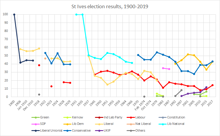
St Ives is a parliamentary constituency covering the western end of Cornwall and the Isles of Scilly. The constituency has been represented in the House of Commons of the UK Parliament since 2015 by Derek Thomas, a Conservative MP. The area's voters produced the 22nd closest result in the 2017 general election; a winning margin of 312 votes. Since 1992, the same locally leading two parties' candidates who were fielded (varying at different times) have won at least 27.2% of the vote each; the third placed candidate, that of the Labour Party, has fluctuated between 8.2% and 15.2% of share of the vote. Constituency profile The seat covers the southern end of Cornwall and the Isles of Scilly. Tourism is a significant sector in this former mining area. History St Ives has elected MPs to every Parliament since 1558, except for a brief period during the Protectorate. It was originally a mere parliamentary borough that returned two MPs until the Great Reform Act of 1832, when its r ... [...More Info...] [...Related Items...] OR: [Wikipedia] [Google] [Baidu] |
Heamoor
Heamoor (formerly Hea) ( kw, An Hay) is a village in Cornwall, England. Formerly a secondary settlement of the village of Madron, Heamoor is situated approximately one-and-a half kilometres (just over a mile) northwest of Penzance town centre. The village is in the civil parish of Penzance and forms a single ward on Penzance Town Council. The principal local authority is Cornwall Council. In May 2019, Heamoor residents voted at a public meeting to submit a bid under Cornwall Council's Community Governance Review to split from Penzance Town Council and form a separate parish council to be known as Heamoor Village Council. Volunteers from the community have set up a Steering Group to prepare a bid (submitted in July 2019), build community awareness, and manage the transitional arrangements. Heamoor is one of only two communities in Cornwall to have applied to create a new local council in the Community Governance Review. Heamoor has a number of shops, The Sportsman's Arms pub, ... [...More Info...] [...Related Items...] OR: [Wikipedia] [Google] [Baidu] |
Mousehole
Mousehole (; kw, Porthenys) is a village and fishing port in Cornwall, England, UK. It is approximately south of Penzance on the shore of Mount's Bay. The village is in the civil parish of Penzance. An islet called St Clement's Isle lies about offshore from the harbour entrance. Mousehole lies within the Cornwall Area of Outstanding Natural Beauty (AONB). 27% of Cornwall has AONB designation, with the same status and protection as a National Park. History The first mention of the village of ''Mousehole'' is in 1283 and the first mention of ''Portheness'' is in 1267. Although usually thought of as the same place, a document from 1309 names ''Porthenys juxta Mousehole'' (i.e. next to Mousehole), implying two separate places. Compare with nearby Newlyn which is separated by a stream from Tolcarne and both were once considered individual places. There is also a 1339 document naming ''Porthengrous juxta Porthenes'' (harbour by the cross, next to the harbour by the island) ... [...More Info...] [...Related Items...] OR: [Wikipedia] [Google] [Baidu] |
Gulval
Gulval ( kw, Lannystli) is a village in Cornwall, England, United Kingdom. Although historically a parish in its own right, Gulval was incorporated into the parishes of Ludgvan, Madron and Penzance in 1934, and is now considered to be a suburb of Penzance. Gulval still maintains its status as an ecclesiastical parish and parts of the village church date back to the 12th-century. Together with Heamoor, Gulval still retains its status as an electoral ward. The ward population at the 2011 census was 4,185. Name origins The parish is named after a 6th-century saint, Gulval, the original form of which was probably Welvela or Wolvela. Baring-Gould thought this was Wilgitha, the sister of Saint Juthwara: David Nash Ford agrees. Gilbert Hunter Doble, however, favoured an identification with one of the male Welsh missionaries, Gudwall or Gurwall who are honoured in Brittany, eponym of Locoal-Mendon. A life of each one is to be found in the ''Acta Sanctorum'', June; Bollandists, 18 ... [...More Info...] [...Related Items...] OR: [Wikipedia] [Google] [Baidu] |


.jpg)


