|
Peel Hall Tram Stop
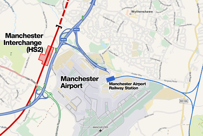
Peel Hall is a tram stop for Phase 3b of the Manchester Metrolink. The station opened on 3 November 2014 and is on the Airport Line on Simonsway next to the junction of Peel Hall Road. The station serves the Peel Hall district of Wythenshawe, Manchester. Services Trams run every 12 minutes north to Victoria and south to Manchester Airport Manchester Airport is an international airport in Ringway, Manchester, England, south-west of Manchester city centre. In 2019, it was the third busiest airport in the United Kingdom in terms of passenger numbers and the busiest of those n ... (every 20 minutes before 6 am). Ticket zones In January 2019, Metrolink ticketing was updated to use a zoned system, and Peel Hall was placed in zone 4. References External links Metrolink stop informationPeel Hall area mapAirport route map Tram stops in Manchester {{UK-metro-stub ... [...More Info...] [...Related Items...] OR: [Wikipedia] [Google] [Baidu] |
Manchester Metrolink
Manchester Metrolink (branded locally simply as Metrolink) is a tram/ light rail system in Greater Manchester, England. The network has 99 stops along of standard-gauge route, making it the most extensive light rail system in the United Kingdom. Metrolink is owned by the public body Transport for Greater Manchester (TfGM) and operated and maintained under contract by a Keolis/ Amey consortium. In 2021/22, 26 million passenger journeys were made on the system. The network consists of eight lines which radiate from Manchester city centre to termini at Altrincham, Ashton-under-Lyne, Bury, East Didsbury, Eccles, Manchester Airport, Rochdale and Trafford Centre. It runs on a mixture of on-street track shared with other traffic; reserved track sections segregated from other traffic, and converted former railway lines. Metrolink is operated by a fleet of 147 high-floor Bombardier M5000 light rail vehicles. Each service runs to a 12-minute headway; stops with more than one serv ... [...More Info...] [...Related Items...] OR: [Wikipedia] [Google] [Baidu] |
Wythenshawe
Wythenshawe () is a district of the city of Manchester, England. Historic counties of England, Historically in Cheshire, Wythenshawe was transferred in 1931 to the City of Manchester, which had begun building a massive housing estate there in the 1920s. With an area of approximately , Wythenshawe became the largest Public housing#United Kingdom, council estate in Europe. Wythenshawe includes the estates of Baguley, Benchill, Brooklands, Manchester, Brooklands, Peel Hall, Wythenshawe, Peel Hall, Newall Green, Woodhouse Park, #Moss Nook, Moss Nook, Northern Moor, Northenden and Sharston. History The name of Wythenshawe seems to come from the Old English language, Old English ''wiðign'' = "willow, withy tree" and ''sceaga'' = "wood" (compare dialectal word Shaw (woodland), shaw). The three ancient townships of Northenden, Baguley and Northen Etchells formally became the present-day Wythenshawe when they were merged with Manchester in 1931. Until then, the name had referred only to ... [...More Info...] [...Related Items...] OR: [Wikipedia] [Google] [Baidu] |
City Of Manchester
Manchester () is a city in Greater Manchester, England. It had a population of 552,000 in 2021. It is bordered by the Cheshire Plain to the south, the Pennines to the north and east, and the neighbouring city of Salford to the west. The two cities and the surrounding towns form one of the United Kingdom's most populous conurbations, the Greater Manchester Built-up Area, which has a population of 2.87 million. The history of Manchester began with the civilian settlement associated with the Roman fort (''castra'') of ''Mamucium'' or ''Mancunium'', established in about AD 79 on a sandstone bluff near the confluence of the rivers Medlock and Irwell. Historically part of Lancashire, areas of Cheshire south of the River Mersey were incorporated into Manchester in the 20th century, including Wythenshawe in 1931. Throughout the Middle Ages Manchester remained a manorial township, but began to expand "at an astonishing rate" around the turn of the 19th century. Manchester's unpla ... [...More Info...] [...Related Items...] OR: [Wikipedia] [Google] [Baidu] |
Airport Line (Manchester Metrolink)
The Airport Line is a tram line of the Manchester Metrolink in Greater Manchester running from Manchester city centre to Manchester Airport via the suburb of Wythenshawe. The line was opened in November 2014 as part of phase three of the system's expansion. Route The line runs mostly on reserved track alignments with short sections of street–running. The southern half of the route mostly uses the wide grass verges alongside roads. From Manchester city centre, the route is shared with the Altrincham Line as far as , and then the South Manchester Line as far as . The Airport Line proper starts at a junction just south of St Werburgh's Road stop, where the line leaves the former railway trackbed, and runs off to the south-west. It joins Mauldeth Road, running along the central reservation to stop. It then runs on street along Hardy Lane for a short distance, before crossing onto a tram only viaduct crossing the River Mersey and the Mersey Valley flood plain. The line then con ... [...More Info...] [...Related Items...] OR: [Wikipedia] [Google] [Baidu] |
Tram Stop
A tram stop, tram station, streetcar stop, or light rail station is a place designated for a tram, streetcar, or light rail vehicle to stop so passengers can board or alight it. Generally, tram stops share most characteristics of bus stops, but because trams operate on rails, they often include railway platforms, especially if stepless entries are provided for accessibility. However, trams may also be used with bus stop type flags and with mid-street pavements as platforms, in street running mode. Examples Most tram or streetcar stops in Melbourne and Toronto and other systems with extensive sections of street-running have no associated platforms, with stops in the middle of the roadway pavement. In most jurisdictions, traffic cannot legally pass a tram or streetcar whose doors are open, unless the tram is behind a safety zone or has a designated platform. On the other hand, several light rail systems have high-platform stops or stations with dedicated platforms at railway ... [...More Info...] [...Related Items...] OR: [Wikipedia] [Google] [Baidu] |
Peel Hall, Wythenshawe
Peel Hall is a suburb of Manchester, England, nine miles south of the city centre and a mile north of Manchester Airport. Peel Hall is on the eastern edge of Wythenshawe and borders Heald Green and Gatley in the Metropolitan Borough of Stockport. The area comprises both social and private housing, most of which was built in the 1950s and 1960s. Peel Hall, an Elizabethan moated manor house just off Peel Hall Road at the junction of Lomond Road, belonged to the Egertons of Wythenshawe Hall Wythenshawe Hall is a 16th-century timber-framed historic house and former manor house in Wythenshawe, Manchester, England, five miles (8 km) south of Manchester city centre in Wythenshawe Park. Built for Robert Tatton, it was home to the .... It fell into disrepair in the 1960s and was demolished. The moat survives, surrounded by a park which has recreation facilities and a children's playground. The moat was not defensive but, similar to the one at Little Morton Hall in Cheshire, an ... [...More Info...] [...Related Items...] OR: [Wikipedia] [Google] [Baidu] |
Manchester
Manchester () is a city in Greater Manchester, England. It had a population of 552,000 in 2021. It is bordered by the Cheshire Plain to the south, the Pennines to the north and east, and the neighbouring city of Salford to the west. The two cities and the surrounding towns form one of the United Kingdom's most populous conurbations, the Greater Manchester Built-up Area, which has a population of 2.87 million. The history of Manchester began with the civilian settlement associated with the Roman fort ('' castra'') of ''Mamucium'' or ''Mancunium'', established in about AD 79 on a sandstone bluff near the confluence of the rivers Medlock and Irwell. Historically part of Lancashire, areas of Cheshire south of the River Mersey were incorporated into Manchester in the 20th century, including Wythenshawe in 1931. Throughout the Middle Ages Manchester remained a manorial township, but began to expand "at an astonishing rate" around the turn of the 19th century. Manchest ... [...More Info...] [...Related Items...] OR: [Wikipedia] [Google] [Baidu] |
Manchester Airport Station
Manchester Airport station is a railway, tram, bus and coach station at Manchester Airport, England which opened at the same time as the second air terminal in 1993. The station is south of Manchester Piccadilly, at the end of a short branch from the Styal Line via a triangular junction between Heald Green and Styal stations. Manchester Metrolink tram services were extended to the airport in 2014 and operate to Manchester Victoria. Description The station is south of at the end of a short branch from the Styal Line constructed by British Rail in 1993. A branch of Manchester Metrolink runs into it. It is accessed via a triangular junction located between and . The station platforms are connected by escalator, lift, ramps and an elevated covered walkway (known as the "Sky Link") to the airport terminal buildings in which is a staffed railway ticket office. Throughout the airport complex, the railway station is known as "The Station" and is signposted as such. History New ... [...More Info...] [...Related Items...] OR: [Wikipedia] [Google] [Baidu] |


