|
Pandalur
Pandalur is the headquarters of Neliyalam Municipality and Pandalur taluk in Nilgiri District of Tamilnadu. Location Pandalur is located at 11° 29' 0" N, 76° 20' 0" E, at an altitude of 1100 meters. Its standard time zone is UTC/GMT+05:30. Pandalur is the headquarters of the Pandalur taluk. It is categorized as a third-grade municipality. One roadway is the only access to the town. A number of government bus services are available from: * Ooty (65 km), the district headquarters * Gudalur (23 km), the nearest township * Sulthan Bathery (30 km), one of the nearest municipal towns in Kerala. * The nearest international airports, Calicut International Airport in Kerala (110 km), Coimbatore International Airport (135 km), and Kannur International Airport (137 km) in Kerala. Public and private transportation is available from Pandalur to the nearest villages of the Pandalur Taluk. History The Gudalur and Pandalur taluks of Nilgiris district one t ... [...More Info...] [...Related Items...] OR: [Wikipedia] [Google] [Baidu] |
Pandalur Taluk
Pandalur taluk is a taluk of Nilgiris district of the Indian state of Tamil Nadu. The headquarters of the taluk is the town of Pandalur. History The Gudalur and Pandalur taluks of Nilgiris district one time together constituted the Southeast Wayanad. The total area of Gudalur and the neighboring town of Pandalur is approximately 124,800 acres. In medieval times, before the arrival of the British, the area was divided between three rulers: Vallavanoor, the leader of the Paniya people, Panniyas, Nelliarasi, another adivasi ruler, and the Nilambur Kingdom, Nilambur Kovilakam, a kingdom based in present-day Kerala. Subsequently, the Kovilakam decided to expand its borders by conquering the other two areas. Vallavanoor was killed and Nelliarasi kidnapped and forced to hand over her lands. Despite some resistance from Vallavanoor's community, the Kovilakam succeeded in subjugating the area and taking approximately 100,000 acres under its control. Gudalur was actually a part of Kerala a ... [...More Info...] [...Related Items...] OR: [Wikipedia] [Google] [Baidu] |
Nilgiris District
The Nilgiris district () is one of the 38 districts in the southern Indian state of Tamil Nadu. Nilgiri ( en, Blue Mountains) is the name given to a range of mountains spread across the borders among the states of Tamil Nadu, Karnataka and Kerala. The Nilgiri Hills are part of a larger mountain chain known as the Western Ghats. Their highest point is the mountain of Doddabetta, height 2,637 m. The district is contained mainly within the Nilgiri Mountains range. The administrative headquarters is located at Ooty (Ootacamud or Udhagamandalam). The district is bounded by Malappuram district of Kerala to the west, Coimbatore and Palakkad to the south, Erode to the east, and Chamarajnagar district of Karnataka and Wayanad district of Kerala to the north. As it is located at the junction of three states, namely, Tamil Nadu, Kerala, and Karnataka, significant Malayali and Kannadiga populations reside in the district. Nilgiris district is known for natural mines of Gold, which is ... [...More Info...] [...Related Items...] OR: [Wikipedia] [Google] [Baidu] |
Malabar District
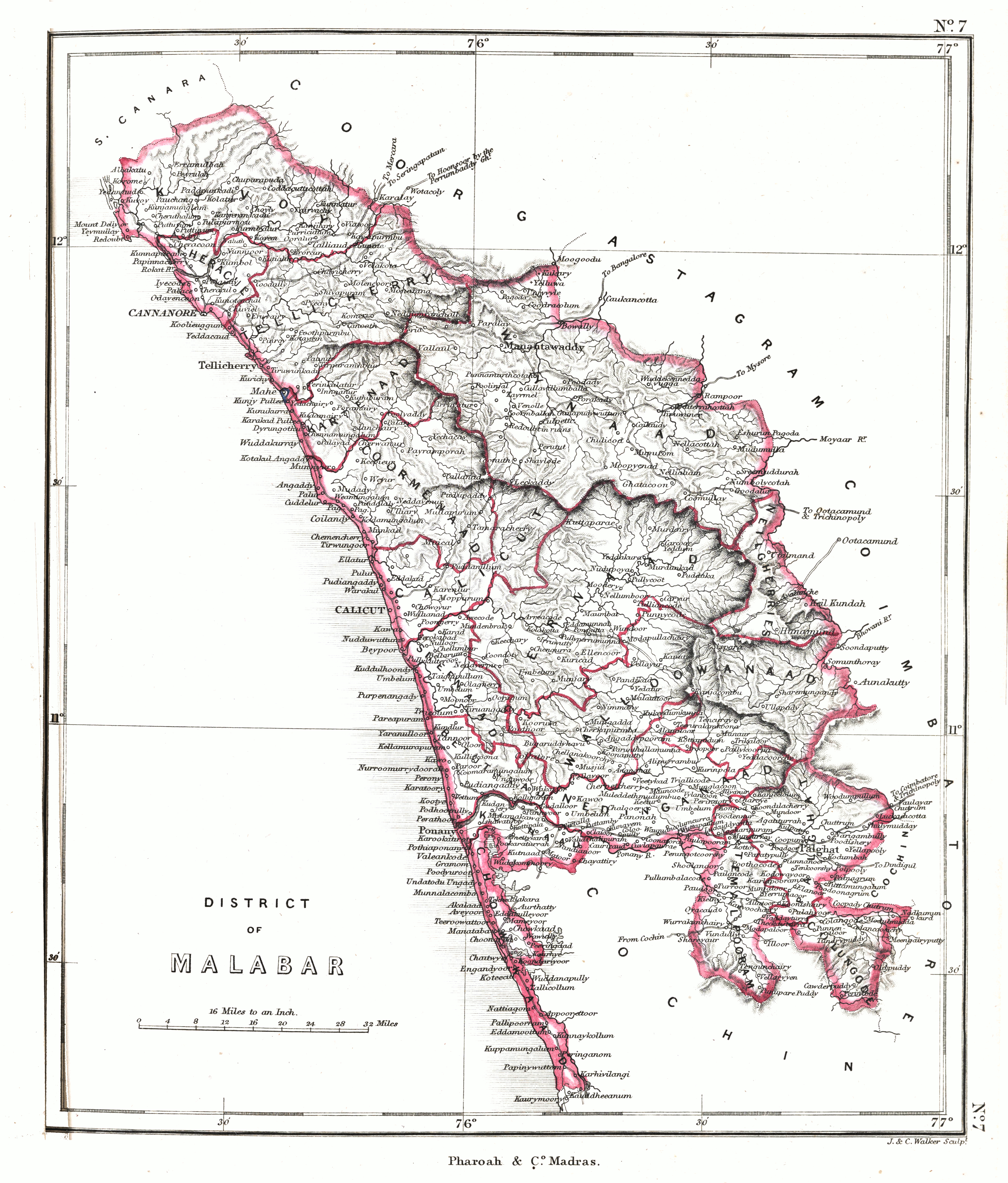
Malabar District, also known as Malayalam District, was an administrative district on the southwestern Malabar Coast of Bombay Presidency (1792-1800) and Madras Presidency (1800-1947) in British India, and independent India's Madras State (1947-1956). It was the most populous and the third-largest district in the erstwhile Madras State. The British district included the present-day districts of Kannur, Kozhikode, Wayanad, Malappuram, Palakkad (excluding Chittur town), Chavakad Taluk and parts of Kodungallur Taluk of Thrissur district (former part of Ponnani Taluk), and Fort Kochi area of Ernakulam district in the northern and central parts of present Kerala state, the Lakshadweep Islands, and a major portion of the Nilgiris district in Tamil Nadu. The detached settlements of Tangasseri and Anchuthengu, which were British colonies within the kingdom of Travancore in southern Kerala, also formed part of Malabar District until 1927. Malayalam was the administrative as well as ... [...More Info...] [...Related Items...] OR: [Wikipedia] [Google] [Baidu] |
Wayanad District
Wayanad () is a district in the north-east of Indian state Kerala with administrative headquarters at the municipality of Kalpetta. It is the only plateau in Kerala. The Wayanad Plateau forms a continuation of the Mysore Plateau, the southern portion of Deccan Plateau. It is set high in the Western Ghats with altitudes ranging from 700 to 2100 meters. Vellari Mala, a high peak situated on the trijunction of Wayanad, Malappuram, and Kozhikode districts, is the highest point in Wayanad district. The district was formed on 1 November 1980 as the 12th district in Kerala, by carving out areas from Kozhikode and Kannur districts. An area of 885.92 km2 of the district is forested. Wayanad has three municipal towns— Kalpetta, Mananthavady and Sulthan Bathery. There are many indigenous tribes in this area. The Kabini River, a tributary of Kaveri River, originates at Wayanad. Wayanad district, along with the Chaliyar valley in neighbouring Nilambur (Eastern Eranad region) i ... [...More Info...] [...Related Items...] OR: [Wikipedia] [Google] [Baidu] |
Wayanad
Wayanad () is a district in the north-east of Indian state Kerala with administrative headquarters at the municipality of Kalpetta. It is the only plateau in Kerala. The Wayanad Plateau forms a continuation of the Mysore Plateau, the southern portion of Deccan Plateau. It is set high in the Western Ghats with altitudes ranging from 700 to 2100 meters. Vellari Mala, a high peak situated on the trijunction of Wayanad, Malappuram, and Kozhikode districts, is the highest point in Wayanad district. The district was formed on 1 November 1980 as the 12th district in Kerala, by carving out areas from Kozhikode and Kannur districts. An area of 885.92 km2 of the district is forested. Wayanad has three municipal towns— Kalpetta, Mananthavady and Sulthan Bathery. There are many indigenous tribes in this area. The Kabini River, a tributary of Kaveri River, originates at Wayanad. Wayanad district, along with the Chaliyar valley in neighbouring Nilambur (Eastern Eranad region) i ... [...More Info...] [...Related Items...] OR: [Wikipedia] [Google] [Baidu] |
Gudalur, Nilgiris
Gudalur is a municipality and taluk in Nilgiris district in the Indian state of Tamil Nadu. Demographics Religions Languages According to 2011 census, Gudalur had a population of 49,535 with a sex-ratio of 1,032 females for every 1,000 males, much above the national average of 929. A total of 5,359 were under the age of six, constituting 2,719 males and 2,640 females. Scheduled Castes and Scheduled Tribes accounted for 27.66% and 3.65% of the population respectively. The literacy rate of the town was 79.48%, compared to the national average of 72.99%. The town had a total of 12101 households. There were a total of 18,807 workers, comprising 551 cultivators, 1,759 main agricultural labourers, 206 household industries, 14,488 other workers, 1,803 marginal workers, 90 marginal cultivators, 278 marginal agricultural labourers, 119 marginal workers in household industries and 1,316 other marginal workers. As per the religious census of 2011, Gudalur had 59.83% Hindus, 26.01% ... [...More Info...] [...Related Items...] OR: [Wikipedia] [Google] [Baidu] |
Mangalore
Mangalore (), officially known as Mangaluru, is a major port city of the Indian state of Karnataka. It is located between the Arabian Sea and the Western Ghats about west of Bangalore, the state capital, 20 km north of Karnataka–Kerala border, 297 km south of Goa. Mangalore is the state's only city to have all four modes of transport—air, road, rail and sea. The population of the urban agglomeration was 619,664 national census of India. It is known for being one of the locations of the Indian strategic petroleum reserves. The city developed as a port in the Arabian Sea during ancient times, and has since become a major port of India that handles 75 percent of India's coffee and cashew exports. It is also the country's seventh largest container port. Mangalore has been ruled by several major powers, including the Kadambas, Alupas, Vijayanagar Empire, Keladi Nayaks, and the Portuguese. The city was a source of contention between the Britis ... [...More Info...] [...Related Items...] OR: [Wikipedia] [Google] [Baidu] |
Kodagu
Kodagu (also known by its former name Coorg) is an administrative district in the Karnataka state of India. Before 1956, it was an administratively separate Coorg State, at which point it was merged into an enlarged Mysore State. It occupies an area of in the Western Ghats of southwestern Karnataka. In 2001 its population was 548,561, 13.74% of which resided in the district's urban centre, making it the least populous of the 31 districts in Karnataka. The nearest railway stations are Mysore Junction, located around away, Thalassery, and Kannur, the latter two located in Kerala at a distance of about . The nearest airports are Kannur International Airport in Kerala ( from Madikeri) and Mangalore International Airport ( from Madikeri). Geography Kodagu is located on the eastern slopes of the Western Ghats. It has a geographical area of . The district is bordered by Dakshina Kannada district to the northwest, Hassan district to the north, Mysore district to the east, Kasara ... [...More Info...] [...Related Items...] OR: [Wikipedia] [Google] [Baidu] |
Sangam Literature
The Sangam literature (Tamil: சங்க இலக்கியம், ''caṅka ilakkiyam'';) historically known as 'the poetry of the noble ones' (Tamil: சான்றோர் செய்யுள், ''Cāṉṟōr ceyyuḷ'') connotes the ancient Tamil literature and is the earliest known literature of South India. The Tamil tradition and legends link it to three literary gatherings around Madurai and Kapāṭapuram ( Pandyan capitals): the first over 4,440 years, the second over 3,700 years, and the third over 1,850 years before the start of the common era. Scholars consider this Tamil tradition-based chronology as ahistorical and mythical. Most scholars suggest the historical Sangam literature era spanned from c. 300 BCE to 300 CE, while others variously place this early classical Tamil literature period a bit later and more narrowly but all before 300 CE. According to Kamil Zvelebil – a Tamil literature and history scholar, the most acceptable range for the Sangam ... [...More Info...] [...Related Items...] OR: [Wikipedia] [Google] [Baidu] |
Mushika Dynasty
Mushika dynasty, also spelled Mushaka, was a minor dynastic power that held sway over the region in and around Mount Ezhi (Ezhimala (hill, Kannur), Ezhimala) in present-day North Malabar, Kerala, India. The country of the Mushikas, ruled by an ancient lineage of the Hehaya clan of the same name, appears in Sangam period, early historic (pre-Pallava) south India.Gurukkal, Rajan. “DID STATE EXIST IN THE PRE-PALLAVAN TAMIL REGION.” ''Proceedings of the Indian History Congress'', vol. 63, 2002, pp. 138–150. Early Tamil poems contain several references to the exploits of Nannan of Ezhimalai. Nannan was known as a great enemy of the pre-Pallava dynasty, Pallava Chera dynasty, Chera chieftains.Narayanan, M. G. S. ''Perumāḷs of Kerala.'' Thrissur (Kerala): CosmoBooks, 2013. 195. The clan also had matrimonial alliances with the Chera, Pandya and Chola chieftains. The Kolathunadu (Kannur) Kingdom, which was the descendant of Mushika dynasty, at the peak of its power, reportedly ext ... [...More Info...] [...Related Items...] OR: [Wikipedia] [Google] [Baidu] |
Coimbatore
Coimbatore, also spelt as Koyamputhur (), sometimes shortened as Kovai (), is one of the major metropolitan cities in the Indian state of Tamil Nadu. It is located on the banks of the Noyyal River and surrounded by the Western Ghats. Coimbatore is the second largest city in Tamil Nadu after Chennai in terms of population and the 16th largest urban agglomeration in India as per the census 2011. It is administered by the Coimbatore Municipal Corporation and is the administrative capital of Coimbatore District. In 1981 Coimbatore formed as third municipal corporation in Tamil Nadu after Chennai and Madurai. Podanur Junction is the oldest Railway station in Coimbatore City. The city is one of the largest exporters of Jewellery, Wet grinders, Poultry and Auto Components; the "Coimbatore Wet Grinder" and the " Kovai Cora Cotton" are recognised as Geographical Indications by the Government of India. Being a hub of textile industry in South India, the city is sometimes referred to ... [...More Info...] [...Related Items...] OR: [Wikipedia] [Google] [Baidu] |


.jpg)
.png)


