|
Pacific Coast Highway Station (Blue Line)
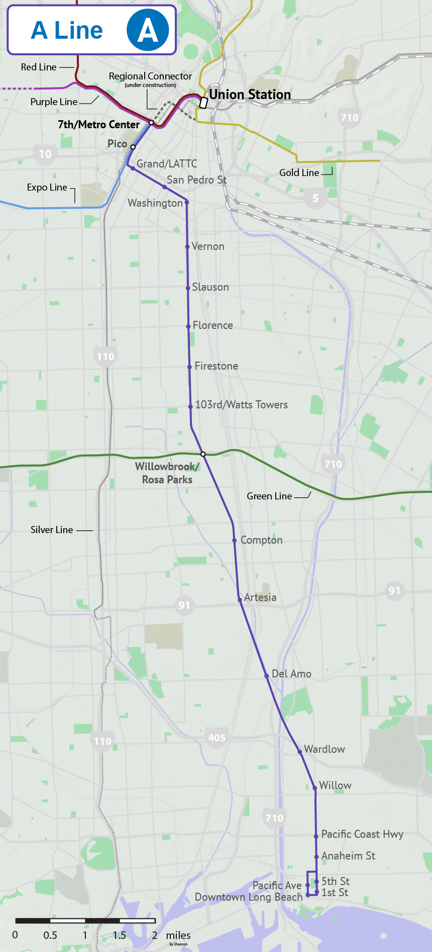
Pacific Coast Highway station is an at grade light rail station on the A Line of the Los Angeles Metro Rail system. The station is located in the median of Long Beach Boulevard at its intersection with Pacific Coast Highway, after which the station is named, in Long Beach, California. North of this station, A Line trains enter an exclusive right-of-way (the historic route of the Pacific Electric Railway) which allows trains to reach higher speeds between stops. A J Line station with an identical name is located approximately west of this station. Service Station layout Hours and frequency Connections , the following connections are available: *Long Beach Transit: , , , , , *Los Angeles Metro Bus Los Angeles Metro Bus is the transit bus service in Los Angeles County, California operated by the Los Angeles County Metropolitan Transportation Authority (Metro). In , the system had a ridership of , or about per weekday as of . , there are ...: Referenc ... [...More Info...] [...Related Items...] OR: [Wikipedia] [Google] [Baidu] |
Long Beach Boulevard (California)
Long Beach Boulevard is a north–south thoroughfare in Los Angeles County. Geography Long Beach Boulevard starts off as a continuation of Pacific Boulevard south of Cudahy Street in Walnut Park. Long Beach Boulevard passes through South Gate, Lynwood, Compton and Long Beach. It ends at Ocean Boulevard in Long Beach. It crosses intersection with Firestone Boulevard (formerly State Route 42), Interstate 105 (Century Freeway), State Route 91 (Gardena Freeway), Interstate 710 (Long Beach Freeway), Interstate 405 (San Diego Freeway), and State Route 1 (Pacific Coast Highway). History A segment of this street in Long Beach was originally named American Avenue, a name provided by local developer William Willmore. In 1958, Gerald Desmond and other members of the Long Beach City Council decided to begin the process of renaming this stretch of road to Long Beach Boulevard. In the 1970s, Long Beach Boulevard was lined with gay, lesbian, and transvestite bars. Sailors fro ... [...More Info...] [...Related Items...] OR: [Wikipedia] [Google] [Baidu] |
Los Angeles Metro Rail
The Los Angeles Metro Rail is an urban rail transit system serving Los Angeles County, California, United States. It consists of seven lines, including five light rail lines (the A Line (Los Angeles Metro), A, C Line (Los Angeles Metro), C, E Line (Los Angeles Metro), E, K Line (Los Angeles Metro), K, L Line (Los Angeles Metro), L lines) and two rapid transit (known locally as a subway) lines (the B Line (Los Angeles Metro), B and D Line (Los Angeles Metro), D lines) serving List of Los Angeles County Metro Rail stations, 99 stations. It connects with the Los Angeles Metro Busway, Metro Busway bus rapid transit system (the G Line (Los Angeles Metro), G and J Line (Los Angeles Metro), J lines), the Metrolink (California), Metrolink commuter rail system, and several Amtrak lines. Metro Rail is owned and operated by the Los Angeles County Metropolitan Transportation Authority (Metro) and started service in 1990. It has been extended significantly since that time and several further ... [...More Info...] [...Related Items...] OR: [Wikipedia] [Google] [Baidu] |
Transportation In Long Beach, California
Transport (in British English), or transportation (in American English), is the intentional movement of humans, animals, and goods from one location to another. Modes of transport include air, land (rail and road), water, cable, pipeline, and space. The field can be divided into infrastructure, vehicles, and operations. Transport enables human trade, which is essential for the development of civilizations. Transport infrastructure consists of both fixed installations, including roads, railways, airways, waterways, canals, and pipelines, and terminals such as airports, railway stations, bus stations, warehouses, trucking terminals, refueling depots (including fueling docks and fuel stations), and seaports. Terminals may be used both for interchange of passengers and cargo and for maintenance. Means of transport are any of the different kinds of transport facilities used to carry people or cargo. They may include vehicles, riding animals, and pack animals. Vehicles may inclu ... [...More Info...] [...Related Items...] OR: [Wikipedia] [Google] [Baidu] |
A Line (Los Angeles Metro) Stations
A-line or A Line may refer to: Transport * A (New York City Subway service), rapid transit line * A Line (Los Angeles Metro), a light rail line in Los Angeles County, California * A Line (RTD), commuter rail line between Denver and Aurora, Colorado * Atlantic Coast Line Railroad, rail line in Florida * A Line (Minnesota), a bus rapid transit line in Minneapolis, Saint Paul, and Roseville, Minnesota * A-Line (Hamilton), planned rapid transit line in Hamilton, Ontario, Canada * RapidRide A Line, bus route in King County, Washington * Line A (Buenos Aires Underground), Argentina * RER A, commuter rail line in Paris, France * A (Los Angeles Railway), former streetcar service Other uses * A-line (clothing), a style of skirt or dress * Arterial line, a thin catheter inserted into an artery * A-line - a finding in medical ultrasound of the lung See also * A-A line * Aline (other) * Line A (other) * Line (other) Line most often refers to: * Line (geometr ... [...More Info...] [...Related Items...] OR: [Wikipedia] [Google] [Baidu] |
Pacific Coast Highway Station (J Line)
Pacific Coast Highway station is a elevated busway station on the J Line of the Los Angeles Metro Busway system. The station is located on the shoulder of Interstate 110 at its intersection with Pacific Coast Highway, after which the station is named, in Los Angeles County, California. It is one of two stations along the Harbor Freeway are outside of the Harbor Transitway, a shared busway and high occupancy toll lane. South of this station the J Line exits the Harbor Freeway and starts serving San Pedro, starting with the Harbor Beacon Park & Ride. Traveling north on I-110 the next station is Carson. The station is located close to Los Angeles Harbor College, Kaiser Permanente South Bay Medical Center, Ken Malloy Harbor Regional Park, and has a 240 space park and ride lot. An A Line station with an identical name is located approximately east of the station. Service Station layout The side platforms can be accessed on foot from the Pacific Coast Highway using stai ... [...More Info...] [...Related Items...] OR: [Wikipedia] [Google] [Baidu] |
J Line (Los Angeles Metro)
The J Line (formerly the Silver Line, sometimes listed as Line 910/950) is a bus rapid transit route that runs between El Monte, Downtown Los Angeles and Gardena, with some trips continuing to San Pedro. It is one of the two lines in the Metro Busway system operated by the Los Angeles County Metropolitan Transportation Authority (Metro). The J Line offers frequent, all-stops service along the El Monte Busway and the Harbor Transitway, two grade-separated transit facilities built into the Southern California freeway system. The line was created on December 13, 2009, as part of the conversion of the facilities from high-occupancy vehicle lanes into high-occupancy toll lanes (branded as Metro ExpressLanes) that allow solo drivers to pay a toll to use lanes. The tolls collected have been used to operate the J Line and refurbish the aged stations on the line. As J Line buses travel along the El Monte Busway and the Harbor Transitway they serve stations built into the center ... [...More Info...] [...Related Items...] OR: [Wikipedia] [Google] [Baidu] |
Pacific Electric Railway
The Pacific Electric Railway Company, nicknamed the Red Cars, was a privately owned mass transit system in Southern California consisting of electrically powered streetcars, interurban cars, and buses and was the largest electric railway system in the world in the 1920s. Organized around the city centers of Los Angeles and San Bernardino, it connected cities in Los Angeles County, Orange County, San Bernardino County and Riverside County. The system shared dual gauge track with the narrow gauge Los Angeles Railway, "Yellow Car," or "LARy" system on Main Street in downtown Los Angeles (directly in front of the 6th and Main terminal), on 4th Street, and along Hawthorne Boulevard south of downtown Los Angeles toward the cities of Hawthorne, Gardena, and Torrance. Districts The system had four districts: * Northern District: San Gabriel Valley, including Pasadena, Mount Lowe, South Pasadena, Alhambra, El Monte, Covina, Duarte, Glendora, Azusa, Sierra Madre, and Monrovia. * ... [...More Info...] [...Related Items...] OR: [Wikipedia] [Google] [Baidu] |
Right-of-way (railroad)
A right-of-way (ROW) is a right to make a way over a piece of land, usually to and from another piece of land. A right of way is a type of easement granted or reserved over the land for transportation purposes, such as a highway, public footpath, rail transport, canal, as well as electrical transmission lines, oil and gas pipelines. In the case of an easement, it may revert to its original owners if the facility is abandoned. This American English term is also used to denote the land itself. A right of way is granted or reserved over the land for transportation purposes, usually for private access to private land and, historically for a highway, public footpath, rail transport, canal, as well as electrical transmission lines, oil and gas pipelines.Henry Campbell Black: ''Right-of-way.'' In''A law dictionary containing definitions of the terms and phrases of American and English jurisprudence, ancient and modern: and including the principal terms of international, constitutiona ... [...More Info...] [...Related Items...] OR: [Wikipedia] [Google] [Baidu] |
California State Route 1
State Route 1 (SR 1) is a major north–south state highway that runs along most of the Pacific coastline of the U.S. state of California. At , it is the longest state route in California, and the second-longest in the US after Montana Highway 200. SR 1 has several portions designated as either Pacific Coast Highway (PCH), Cabrillo Highway, Shoreline Highway, or Coast Highway. Its southern terminus is at Interstate 5 (I-5) near Dana Point in Orange County and its northern terminus is at U.S. Route 101 (US 101) near Leggett in Mendocino County. SR 1 also at times runs concurrently with US 101, most notably through a stretch in Ventura and Santa Barbara counties, and across the Golden Gate Bridge. The highway is designated as an All-American Road. In addition to providing a scenic route to numerous attractions along the coast, the route also serves as a major thoroughfare in the Greater Los Angeles Area, the San Francisco Bay Area, and several ... [...More Info...] [...Related Items...] OR: [Wikipedia] [Google] [Baidu] |
A Line (Los Angeles Metro)
The A Line (formerly, from 1990-2019, and colloquially known as Blue Line) is a light rail line running north–south between Los Angeles and Long Beach, California, passing through Downtown Los Angeles, South Los Angeles, Watts, Willowbrook, Compton, Rancho Dominguez, and Long Beach in Los Angeles County. It is one of seven lines in the Metro Rail system. Opened in 1990, it is the system's oldest and third-busiest line with an estimated 22.38 million boardings per year . It is operated by the Los Angeles County Metropolitan Transportation Authority. The A Line passes near the cities of Vernon, Huntington Park, South Gate, Lynwood, and Carson. The famous Watts Towers art installation is visible from the train tracks near 103rd Street station. The under-construction Regional Connector will directly link this line to Union Station and into the San Gabriel Valley along the current route of the L Line, resulting in a longer A Line and the elimination of the L Line. Se ... [...More Info...] [...Related Items...] OR: [Wikipedia] [Google] [Baidu] |
Long Beach, California
Long Beach is a city in Los Angeles County, California. It is the 42nd-most populous city in the United States, with a population of 466,742 as of 2020. A charter city, Long Beach is the seventh-most populous city in California. Incorporated in 1897, Long Beach lies in Southern California in the southern part of Los Angeles County. Long Beach is approximately south of downtown Los Angeles, and is part of the Gateway Cities region. The Port of Long Beach is the second busiest container port in the United States and is among the world's largest shipping ports. The city is over an oilfield with minor wells both directly beneath the city as well as offshore. The city is known for its waterfront attractions, including the permanently docked and the Aquarium of the Pacific. Long Beach also hosts the Grand Prix of Long Beach, an IndyCar race and the Long Beach Pride Festival and Parade. California State University, Long Beach, one of the largest universities in California b ... [...More Info...] [...Related Items...] OR: [Wikipedia] [Google] [Baidu] |
.jpg)


