|
Oryukdo
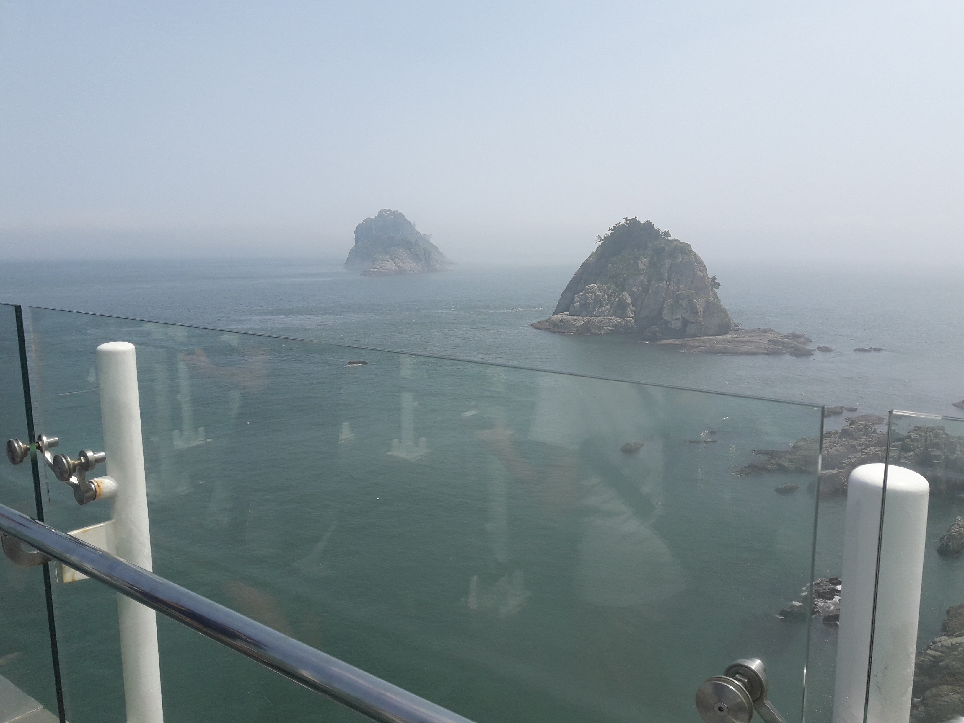
Oryukdo (literally meaning ''Five–Six island'') is group of islands located in Yongho-dong, Nam-gu, Busan, South Korea South Korea, officially the Republic of Korea (ROK), is a country in East Asia, constituting the southern part of the Korean Peninsula and sharing a land border with North Korea. Its western border is formed by the Yellow Sea, while its eas .... The name reflects the fact that the island group can consist of either five or six islands, depending on the current tides. The islands are uninhabited except for Deungdaedo, which has a lighthouse. The other islands are Usakdo, Surido, Gonggotdo, and Guldo. Depending on water level, Usakdo can also be separated into two islands, which are then named Bangpaedo and Sol. The Oryukdo Skywalk is a glass viewing platform positioned on a cliff overlooking the islands which opened in 2013. References Islands of Busan Nam District, Busan Islands of the Sea of Japan {{SouthKorea-geo-stub ... [...More Info...] [...Related Items...] OR: [Wikipedia] [Google] [Baidu] |
Oryukdo Skywalk
Oryukdo (literally meaning ''Five–Six island'') is group of islands located in Yongho-dong, Nam-gu, Busan, South Korea South Korea, officially the Republic of Korea (ROK), is a country in East Asia, constituting the southern part of the Korean Peninsula and sharing a land border with North Korea. Its western border is formed by the Yellow Sea, while its eas .... The name reflects the fact that the island group can consist of either five or six islands, depending on the current tides. The islands are uninhabited except for Deungdaedo, which has a lighthouse. The other islands are Usakdo, Surido, Gonggotdo, and Guldo. Depending on water level, Usakdo can also be separated into two islands, which are then named Bangpaedo and Sol. The Oryukdo Skywalk is a glass viewing platform positioned on a cliff overlooking the islands which opened in 2013. References Islands of Busan Nam District, Busan Islands of the Sea of Japan {{SouthKorea-geo-stub ... [...More Info...] [...Related Items...] OR: [Wikipedia] [Google] [Baidu] |
Nam District, Busan
Nam District (literally ''south district'') is a '' gu'', or district, in south central Busan, South Korea. Much of Nam-gu sticks out into the Sea of Japan ( East Sea), forming a peninsula which separates Suyeong Bay from Busan Harbor. It has an area of 25.91 km². Nam-gu officially became a ''gu'' of Busan in 1975. In 1995 part of Nam-gu was divided to form Suyeong-gu. The Busan International Finance Center is located here. Demographics Nam-gu is home to some 300,000 people, for a population density exceeding 11,000 per square kilometer. Less than 1,000 of its inhabitants are non-Korean. Busan Subway The Busan Subway (line 2) passes through Nam-gu, where an interchange connects it to the highway leading to the Gwangan Bridge. Six subway stations along Busan Subway (line 2) are located in Nam-gu, going from ''Kyungsung University'' · ''Pukyong National University'' Station to ''Busan International Finance Center'' Station. Geography Nam-gu contains a total of 7 islands, a ... [...More Info...] [...Related Items...] OR: [Wikipedia] [Google] [Baidu] |
Yongho-dong, Busan
Yongho-dong is a '' dong'' on the coast of Busan, a major port city in southeastern South Korea. Its mainland portion is bordered on three sides by water, standing on a peninsula which separates Busan Harbor from Suyeong Bay. Its boundaries include the famed islets of Oryukdo, and several other small uninhabited islands. Yongho-dong is a legal ''dong''; for administrative purposes, it is divided into four administrative ''dong'': Yongho 1,2,3, and 4-dong. Yongho 1-dong alone, with more than 43,000 people, is the most heavily populated administrative dong in Nam-gu. Yongho-dong is densely populated; its 7 square kilometers of land are home to more than 72,000 people. Thanks to its proximity to the harbor, it is also the site of a campus of the Korea Institute of Maritime and Fisheries Technology. There are varying accounts of the origin of the name "Yongho," which dates to the Japanese occupation. The second syllable ''ho'' means lake, and refers to a salt pan which once ... [...More Info...] [...Related Items...] OR: [Wikipedia] [Google] [Baidu] |
Korea Strait
The Korea Strait is a sea passage in East Asia between Korea and Japan, connecting the East China Sea, the Yellow Sea and the Sea of Japan in the northwest Pacific Ocean. The strait is split by the Tsushima Island into the Western Channel and the Tsushima Strait or Eastern Channel. Geography To the north, the Korea Strait is bounded by the southern coast of the Korean Peninsula. And to the south, it by the southwestern Japanese islands of Kyūshū and Honshū. It is about wide and averages about 90 to 100 meters (300 ft) deep. Tsushima Island divides the Korea Strait into the western channel and the Tsushima Strait. The western channel is deeper (up to 227 meters) and narrower than the Tsushima Strait. Currents A branch of the Kuroshio Current passes through the strait. Its warm branch is sometimes called the Tsushima Current. Originating along the Japanese islands this current passes through the Sea of Japan then divides along either shore of Sakhalin Isla ... [...More Info...] [...Related Items...] OR: [Wikipedia] [Google] [Baidu] |
South Korea
South Korea, officially the Republic of Korea (ROK), is a country in East Asia, constituting the southern part of the Korea, Korean Peninsula and sharing a Korean Demilitarized Zone, land border with North Korea. Its western border is formed by the Yellow Sea, while its eastern border is defined by the Sea of Japan. South Korea claims to be the sole legitimate government of the entire peninsula and List of islands of South Korea, adjacent islands. It has a Demographics of South Korea, population of 51.75 million, of which roughly half live in the Seoul Capital Area, the List of metropolitan areas by population, fourth most populous metropolitan area in the world. Other major cities include Incheon, Busan, and Daegu. The Korean Peninsula was inhabited as early as the Lower Paleolithic period. Its Gojoseon, first kingdom was noted in Chinese records in the early 7th century BCE. Following the unification of the Three Kingdoms of Korea into Unified Silla, Silla and Balhae in the ... [...More Info...] [...Related Items...] OR: [Wikipedia] [Google] [Baidu] |
Busan
Busan (), officially known as is South Korea's most populous city after Seoul, with a population of over 3.4 million inhabitants. Formerly romanized as Pusan, it is the economic, cultural and educational center of southeastern South Korea, with its port being Korea's busiest and the sixth-busiest in the world. The surrounding "Southeastern Maritime Industrial Region" (including Ulsan, South Gyeongsang, Daegu, and some of North Gyeongsang and South Jeolla) is South Korea's largest industrial area. The large volumes of port traffic and urban population in excess of 1 million make Busan a Large-Port metropolis using the Southampton System of Port-City classification . Busan is divided into 15 major administrative districts and a single county, together housing a population of approximately 3.6 million. The full metropolitan area, the Southeastern Maritime Industrial Region, has a population of approximately 8 million. The most densely built-up areas of the city are situated in ... [...More Info...] [...Related Items...] OR: [Wikipedia] [Google] [Baidu] |
Lighthouse
A lighthouse is a tower, building, or other type of physical structure designed to emit light from a system of lamps and lenses and to serve as a beacon for navigational aid, for maritime pilots at sea or on inland waterways. Lighthouses mark dangerous coastlines, hazardous shoals, reefs, rocks, and safe entries to harbors; they also assist in aerial navigation. Once widely used, the number of operational lighthouses has declined due to the expense of maintenance and has become uneconomical since the advent of much cheaper, more sophisticated and effective electronic navigational systems. History Ancient lighthouses Before the development of clearly defined ports, mariners were guided by fires built on hilltops. Since elevating the fire would improve the visibility, placing the fire on a platform became a practice that led to the development of the lighthouse. In antiquity, the lighthouse functioned more as an entrance marker to ports than as a warning signal for reefs a ... [...More Info...] [...Related Items...] OR: [Wikipedia] [Google] [Baidu] |
Islands Of Busan
An island (or isle) is an isolated piece of habitat that is surrounded by a dramatically different habitat, such as water. Very small islands such as emergent land features on atolls can be called islets, skerry, skerries, cays or keys. An river island, island in a river or a lake island may be called an ait, eyot or ait, and a small island off the coast may be called a holm (island), holm. Sedimentary islands in the Ganges delta are called List of islands of Bangladesh, chars. A grouping of geographically or geologically related islands, such as the Philippines, is referred to as an archipelago. There are two main types of islands in the sea: continental and oceanic. There are also artificial islands, which are man-made. Etymology The word ''island'' derives from Middle English ''iland'', from Old English ''igland'' (from ''ig'' or ''ieg'', similarly meaning 'island' when used independently, and -land carrying its contemporary meaning; cf. Dutch language, Dutch ''eiland'' ... [...More Info...] [...Related Items...] OR: [Wikipedia] [Google] [Baidu] |


