|
Ongar Rural District
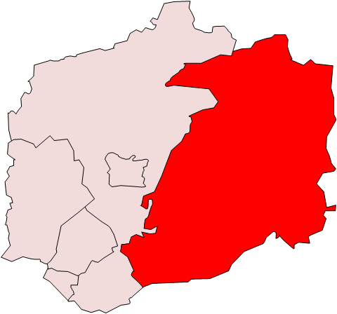
Ongar Rural District was a local government district in Essex, England from 1894 to 1955. – Ongar RD It included the small town of and the parishes surrounding it. It was abolished in 1955 and combined with part of to create Epping and Ongar Rural District
Epping and Ongar Rural District was a rural district in the county of Essex, England from 1955 to 1974.http://w ...
[...More Info...] [...Related Items...] OR: [Wikipedia] [Google] [Baidu] |
Chipping Ongar
Chipping Ongar () is a market town and former civil parish, now in the parish of Ongar, in the Epping Forest District of the county of Essex, England. It is located east of Epping, southeast of Harlow and northwest of Brentwood. In 2020 the built-up area had an estimated population of 6420. In 1961 the parish had a population of 1673. Origin of the name The name "Ongar" means "grass land" (akin to the German word Anger). "Chipping" is from Old English ''cēping'', "a market, a market-place", akin to Danish "købing" and Swedish "köping"; the same element is found in other towns such as Chipping Norton, Chipping Sodbury, Chipping Barnet and Chipping (now High) Wycombe. History Ongar was an important market town in the Medieval era, at the centre of a hundred and has the remains of a Norman castle (see below). The Church of England parish church, St Martin's, dates from the 11th century and shows signs of Norman work. A small window in the chancel is believed to indicat ... [...More Info...] [...Related Items...] OR: [Wikipedia] [Google] [Baidu] |
Rural District
Rural districts were a type of local government area – now superseded – established at the end of the 19th century in England, Wales, and Ireland for the administration of predominantly rural areas at a level lower than that of the Administrative county, administrative counties.__TOC__ England and Wales In England and Wales they were created in 1894 (by the Local Government Act 1894) along with Urban district (Great Britain and Ireland), urban districts. They replaced the earlier system of sanitary districts (themselves based on poor law unions, but not replacing them). Rural districts had elected rural district councils (RDCs), which inherited the functions of the earlier sanitary districts, but also had wider authority over matters such as local planning, council house, council housing, and playgrounds and cemeteries. Matters such as education and major roads were the responsibility of county councils. Until 1930 the rural district councillors were also poor law gu ... [...More Info...] [...Related Items...] OR: [Wikipedia] [Google] [Baidu] |
Epping And Ongar Rural District
Epping and Ongar Rural District was a rural district in the county of Essex, England from 1955 to 1974.http://www.visionofbritain.org.uk/unit_page.jsp?u_id=10074174 Creation It was created in 1955 by the merger of the disbanded Ongar Rural District and most of the disbanded Epping Rural District, except the civil parishes of Great Parndon, Harlow, Latton, Little Parndon and Netteswell, which were largely transferred to the newly created Harlow Urban District reflecting its new town status. The Epping and Ongar administration was based in Epping. List of parishes Abolition At the time of its dissolution it consisted of 29 civil parishes. Since 1 April 1974 it has formed part of the District of Epping Forest, except for the civil parishes of Blackmore, Doddinghurst, Kelvedon Hatch, Navestock and Stondon Massey, which became part of the Borough of Brentwood. See also * Epping Ongar Railway The Epping Ongar Railway is a heritage railway in south-west Essex, England, run ... [...More Info...] [...Related Items...] OR: [Wikipedia] [Google] [Baidu] |
Ongar RD 1911
{{geodis ...
Ongar may refer to: Essex, England *Ongar, Essex, a civil parish *Chipping Ongar, a town **Ongar railway station, a former London Underground station *Hundred of Ongar, an ancient administrative unit *High Ongar, a village in Essex Other uses *Ongar, Dublin, Ireland * Ongar, Sindh, an archaeological site in Pakistan *Ileana Ongar (born 1950), Italian Olympic hurdler See also * Onga (other) Onga may refer to: *Onga District, Fukuoka, a district of Fukuoka Prefecture, Japan **Onga, Fukuoka is a town located in Onga District, Fukuoka Prefecture, Japan. As of 2016, the town has an estimated population of 18,762 and a density of 850 ... [...More Info...] [...Related Items...] OR: [Wikipedia] [Google] [Baidu] |
Essex
Essex () is a county in the East of England. One of the home counties, it borders Suffolk and Cambridgeshire to the north, the North Sea to the east, Hertfordshire to the west, Kent across the estuary of the River Thames to the south, and Greater London to the south and south-west. There are three cities in Essex: Southend, Colchester and Chelmsford, in order of population. For the purposes of government statistics, Essex is placed in the East of England region. There are four definitions of the extent of Essex, the widest being the ancient county. Next, the largest is the former postal county, followed by the ceremonial county, with the smallest being the administrative county—the area administered by the County Council, which excludes the two unitary authorities of Thurrock and Southend-on-Sea. The ceremonial county occupies the eastern part of what was, during the Early Middle Ages, the Anglo-Saxon Kingdom of Essex. As well as rural areas and urban areas, it forms ... [...More Info...] [...Related Items...] OR: [Wikipedia] [Google] [Baidu] |
England
England is a country that is part of the United Kingdom. It shares land borders with Wales to its west and Scotland to its north. The Irish Sea lies northwest and the Celtic Sea to the southwest. It is separated from continental Europe by the North Sea to the east and the English Channel to the south. The country covers five-eighths of the island of Great Britain, which lies in the North Atlantic, and includes over 100 smaller islands, such as the Isles of Scilly and the Isle of Wight. The area now called England was first inhabited by modern humans during the Upper Paleolithic period, but takes its name from the Angles, a Germanic tribe deriving its name from the Anglia peninsula, who settled during the 5th and 6th centuries. England became a unified state in the 10th century and has had a significant cultural and legal impact on the wider world since the Age of Discovery, which began during the 15th century. The English language, the Anglican Church, and Engli ... [...More Info...] [...Related Items...] OR: [Wikipedia] [Google] [Baidu] |
Epping Rural District
Epping was, from 1894 to 1955, a rural district in the administrative county of Essex, England. – Epping RD historic map ) Formation and boundary changes The district was formed by the as successor to the Epping . The rural district was governed by a directly elected rural district council (RDC), which re ...[...More Info...] [...Related Items...] OR: [Wikipedia] [Google] [Baidu] |
Districts Of England Created By The Local Government Act 1894
A district is a type of administrative division that, in some countries, is managed by the local government. Across the world, areas known as "districts" vary greatly in size, spanning regions or counties, several municipalities, subdivisions of municipalities, school district, or political district. By country/region Afghanistan In Afghanistan, a district (Persian ps, ولسوالۍ ) is a subdivision of a province. There are almost 400 districts in the country. Australia Electoral districts are used in state elections. Districts were also used in several states as cadastral units for land titles. Some were used as squatting districts. New South Wales had several different types of districts used in the 21st century. Austria In Austria, the word is used with different meanings in three different contexts: * Some of the tasks of the administrative branch of the national and regional governments are fulfilled by the 95 district administrative offices (). The area a dist ... [...More Info...] [...Related Items...] OR: [Wikipedia] [Google] [Baidu] |
Political History Of Essex
Politics (from , ) is the set of activities that are associated with making decisions in groups, or other forms of power relations among individuals, such as the distribution of resources or status. The branch of social science that studies politics and government is referred to as political science. It may be used positively in the context of a "political solution" which is compromising and nonviolent, or descriptively as "the art or science of government", but also often carries a negative connotation.. The concept has been defined in various ways, and different approaches have fundamentally differing views on whether it should be used extensively or limitedly, empirically or normatively, and on whether conflict or co-operation is more essential to it. A variety of methods are deployed in politics, which include promoting one's own political views among people, negotiation with other political subjects, making laws, and exercising internal and external force, including wa ... [...More Info...] [...Related Items...] OR: [Wikipedia] [Google] [Baidu] |
Epping Forest District
Epping Forest is a local government district in Essex, England. Situated in the west of the county, bordering northeastern Greater London, it is named after, and contains a large part of, Epping Forest. The district, though wholly within the county of Essex, is partly contiguous with Greater London to the south and southwest, and the area around Buckhurst Hill, Chigwell, Waltham Abbey and Loughton is statistically part of the Greater London Built-up Area and forms part of the Ilford (IG) postcode area (except for Waltham Abbey, which forms part of the Enfield (EN) postcode area and Sewardstone, which forms part of the Eastern (E) postcode area). Epping Forest District also borders Hertfordshire both to the northeast and southwest of the neighbouring district of Harlow. Settlement The whole district is divided into civil parishes a majority of which, particularly in the north and east of the district are rural and sparsely populated for an area so close to London; it includ ... [...More Info...] [...Related Items...] OR: [Wikipedia] [Google] [Baidu] |
Borough Of Brentwood
The Borough of Brentwood is a local government district and borough in Essex in the East of England. History and geography The borough is named after its main town of Brentwood. There are still large areas of woodland including Shenfield Common, Hartswood (named after its last private owner, a Mr. Hart), Weald Country Park, and Thorndon Country Park. The original district council was formed in 1974 from the former area of Brentwood Urban District, part of Epping and Ongar Rural District and part of Chelmsford Rural District. By royal charter, the district became a borough on 27 April 1993. Politics The council has 37 councilors, divided between 15 wards with between 1 and 3 councilors. Following the United Kingdom local elections in 2021 the political composition of Brentwood Borough Council is as follows: Boundaries Brentwood is bordered by Epping Forest district (to the north-west), Chelmsford (north-east), Basildon district (south-east), Thurrock (south, aligned wi ... [...More Info...] [...Related Items...] OR: [Wikipedia] [Google] [Baidu] |


.jpg)
