|
Oberpfalz
The Upper Palatinate (german: Oberpfalz, , ) is one of the seven administrative districts of Bavaria, Germany, and is located in the east of Bavaria. Geography The Upper Palatinate is a landscape with low mountains and numerous ponds and lakes in its lowland regions. By contrast with other regions of Germany it is more rural in character and more sparsely settled. It borders (clockwise from the north) on Upper Franconia, the Czech Republic, Lower Bavaria, Upper Bavaria and Middle Franconia. Notable regions are: * Stiftland, former estate and territorial lordship of Waldsassen Abbey with the market town of Konnersreuth, Fockenfeld Abbey, the town of Waldsassen and about 150 other villages. * Upper Palatine Forest with deep valleys and many castles * Upper Palatine Lake District with the Steinberger See * Upper Palatine Jura, part of the Franconian Jura * Steinwald including the Teichelberg and Pechbrunn * Waldnaab/ Wondreb Depression * Bavarian Forest, together with the Boh ... [...More Info...] [...Related Items...] OR: [Wikipedia] [Google] [Baidu] |
Waldnaab
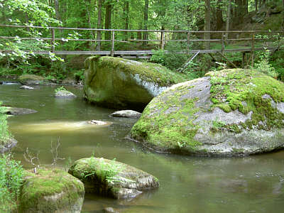
The Waldnaab ( Northern Bavarian: ''Woidnaab'', cs, Lesní Nába, in its upper course: ''Tirschenreuther Waldnaab'') is the left-hand, eastern and longest headstream of the River Naab in the Upper Palatinate (Bavaria, Germany). At its confluence with the Haidenaab near Luhe-Wildenau, the Naab is formed. The Waldnaab is 99.1 km long; combined with the Naab, the total length is . Course The Tirschenreuth Waldnaab The river rises at on the German-Czech border in the Upper Palatine Forest not far from the 901 m high Entenbühl and near its smaller brother, the ''Naabberg'' (). Its source, also called the ''Kreuzbrunnen'', lies in the district of Tirschenreuth, near ''Silberhütte''. From its wellspring the water flows for just under three metres on German soil, before crossing into Bohemia for almost a kilometre, where it is known as the ''Lesní Nába'', and then flowing northwest, re-crossing the German border and reaching Bärnau. As a result of seasonal fluct ... [...More Info...] [...Related Items...] OR: [Wikipedia] [Google] [Baidu] |
Upper Palatine Jura
The Upper Palatinate Jura, also called the Upper Palatine JuraDietz and Kiefer (2016), p. 42. (german: Oberpfalz Jura) is the part of the Franconian Jura. The main part is located in Upper Palatinate (german: Oberpfalz) in Bavaria, Germany. It extends over the districts of Amberg-Sulzbach, Neumarkt, the east of Nürnberger Land, small part in the west of Schwandorf the northwest of Regensburg and north of Kelheim Kelheim () is a town and municipality in Bavaria, Germany. It is the capital of the district Kelheim and is situated at the confluence of the rivers Altmühl and Danube. Kelheim has a population of around 16,750 (2020). History Kelheim is t .... References Literature * Dietz, Christian and Andreas Kiefer (2016). ''Bats of Britain and Europe.'' London & NY: Bloomsbury. * Walentowski, Helge, Gregor Aas, Alexander Göllner, Lisa Ahl and Martin Feulner (2018). ''Phytosociological studies of Malus sylvestris in North Hesse and Upper Franconia, Germany''. Göttinge ... [...More Info...] [...Related Items...] OR: [Wikipedia] [Google] [Baidu] |
Bavaria
Bavaria ( ; ), officially the Free State of Bavaria (german: Freistaat Bayern, link=no ), is a state in the south-east of Germany. With an area of , Bavaria is the largest German state by land area, comprising roughly a fifth of the total land area of Germany. With over 13 million inhabitants, it is second in population only to North Rhine-Westphalia, but due to its large size its population density is below the German average. Bavaria's main cities are Munich (its capital and largest city and also the third largest city in Germany), Nuremberg, and Augsburg. The history of Bavaria includes its earliest settlement by Iron Age Celtic tribes, followed by the conquests of the Roman Empire in the 1st century BC, when the territory was incorporated into the provinces of Raetia and Noricum. It became the Duchy of Bavaria (a stem duchy) in the 6th century AD following the collapse of the Western Roman Empire. It was later incorporated into the Holy Roman Empire, became an ind ... [...More Info...] [...Related Items...] OR: [Wikipedia] [Google] [Baidu] |
Naab
__NOTOC__ The Naab (Czech: ''Nába'') is a river in Bavaria, Germany, and is a left tributary of the Danube. Including its main source river Waldnaab, it is long. Its average discharge at the mouth is . The Naab is formed by the confluence of the Waldnaab and the Haidenaab in Luhe-Wildenau, south of Weiden in der Oberpfalz. It flows generally south, through the towns Nabburg, Schwandorf and Burglengenfeld. It flows into the Danube near Regensburg. See also *List of rivers of Bavaria A list of rivers of Bavaria, Germany: A * Aalbach *Abens * Ach * Afferbach * Affinger Bach * Ailsbach *Aisch * Aiterach *Alpbach *Alster * Altmühl *Alz * Amper * Anlauter * Arbach * Arbachgraben *Aschaff * Aschbach * Attel * Aubach, tributary of ... References Sources * ''Die Naab – mit Waldnaab, Fichtelnaab, Haidenaab.'' (2004) Luftbildband, 132 Seiten, Pustet, Regensburg, 2004. * ''Die Naab – Leben am Fluß im Wandel der Zeit.'' (1998) Buch & Kunstverlag Oberpfalz, Amberg,´ Externa ... [...More Info...] [...Related Items...] OR: [Wikipedia] [Google] [Baidu] |
Steinwald
The Steinwald is a mountain range up to in southern Germany and, at the same time, a nature park (''Steinwald Nature Park'') founded in 1970 with an area of in the province of Upper Palatinate, in North Bavaria. Geography Geographical location The Steinwald lies south of the Upper Franconian county town of Marktredwitz and north of Erbendorf in the district of Tirschenreuth. The Steinwald is separated from the Fichtelgebirge to the northwest by the Waldershof trough (''Waldershofer Senke'') and from the Upper Palatine Forest to the southeast by the Waldnaab-Wondreb-trough. Mountains and hills The mountains and hills in the range and in the Steinwald Nature Park include the following − in order of height in metres (m) above sea level (NN): Geology Like the Fichtelgebirge, the Steinwald consists mainly of granite. In the south and east it is surrounded by a basalt landscape of ''Kuppen'' - gentle, rounded summits - ( Kemnather Land, Nördlicher Steinwald), wh ... [...More Info...] [...Related Items...] OR: [Wikipedia] [Google] [Baidu] |
Konnersreuth
Konnersreuth is a municipality in the district of Tirschenreuth in Bavaria, Germany. It is situated in the northeast foothills of the Steinwald mountains between the Fichtelgebirge mountains and the Upper Palatinate Forest, close to the Czech border. The village is best known as the home of the 20th-century Catholic stigmatist Therese Neumann. History The historical record first mentions Konnersreuth in 1218, in a chronicle kept at Waldsassen Abbey. In 1468 the village was granted the right to hold regular markets. In 1780, the population was 954. The market rights were held by Waldsassen Abbey until about 1803, when the monastery holdings were secularized. The present municipal boundaries were set in the 1818 Bavarian administrative reforms. The coat of arms was awarded in 1468. Three green fir trees stand on a silver background behind a leaping red deer. The coat of arms was renewed in 1978. Therese Neumann In the early 20th century, Konnersreuth was the home of the stigm ... [...More Info...] [...Related Items...] OR: [Wikipedia] [Google] [Baidu] |
Waldsassen Abbey
Waldsassen Abbey (German: ''Abtei Waldsassen'') is a Cistercian nunnery, formerly a Cistercian monastery, located on the River Wondreb at Waldsassen near Tirschenreuth, Oberpfalz, in Bavaria, Germany, close to the border with the Czech Republic. In the Holy Roman Empire it was an Imperial Abbey. History First foundation The monastery, the first Cistercian foundation in Bavaria, was founded by Gerwich of Wolmundstein, a Benedictine monk of Sigeberg Abbey, with the permission of his former abbot Kuno, then Bishop of Regensburg, and built between 1128 and 1132. The original community was sent to Waldsassen from Volkenroda Abbey in Thuringia, of the line of Morimond Abbey. The first abbot was elected in 1133, making this one of the earliest Cistercian foundations. Soon the abbey became one of the most renowned and powerful of the times. As the number of monks increased, several important foundations were made at Senftenberg and Osek in Bohemia, at Walderbach, near Regensbur ... [...More Info...] [...Related Items...] OR: [Wikipedia] [Google] [Baidu] |
Bavarian Forest
The village of Zell in the Bavarian Forest The Bavarian Forest (German: ' or ''Bayerwald''; bar, Boarischa Woid) is a wooded, low-mountain region in Bavaria, Germany that is about 100 kilometres long. It runs along the Czech border and is continued on the Czech side by the Bohemian Forest (Czech: ''Šumava''). Most of the Bavarian Forest lies within the province of Lower Bavaria, but the northern part lies within Upper Palatinate. In the south it reaches the border with Upper Austria. Geologically and geomorphologically, the Bavarian Forest is part of the Bohemian Forest - the highest of the truncated highlands of the Bohemian Massif. The area along the Czech border has been designated as the Bavarian Forest National Park (240 km2), established in 1970 as the first national park in Germany. Another 3,008 km2 has been designated as the Bavarian Forest Nature Park, established 1967, and another 1,738 km2 as the Upper Bavarian Forest Nature Park, established in 1 ... [...More Info...] [...Related Items...] OR: [Wikipedia] [Google] [Baidu] |
Pechbrunn
Pechbrunn is a municipality in the district of Tirschenreuth in Bavaria, Germany Germany,, officially the Federal Republic of Germany, is a country in Central Europe. It is the second most populous country in Europe after Russia, and the most populous member state of the European Union. Germany is situated betwe .... References Tirschenreuth (district) {{Tirschenreuth-geo-stub ... [...More Info...] [...Related Items...] OR: [Wikipedia] [Google] [Baidu] |
Teichelberg
Teichelberg is a mountain of Bavaria, Germany. Mining of a 45-meter thick basalt Basalt (; ) is an aphanitic (fine-grained) extrusive igneous rock formed from the rapid cooling of low-viscosity lava rich in magnesium and iron (mafic lava) exposed at or very near the surface of a rocky planet or moon. More than 90 ... layer started in 1888 References Mountains of Bavaria Mountains under 1000 metres {{Bavaria-geo-stub ... [...More Info...] [...Related Items...] OR: [Wikipedia] [Google] [Baidu] |
Steinberger See
Steinberger See is a lake in Bavaria, Germany. At an elevation of 364 m, its surface area is 1.84 km². Situated in SSE Germany, It is home to its own water Water (chemical formula ) is an Inorganic compound, inorganic, transparent, tasteless, odorless, and Color of water, nearly colorless chemical substance, which is the main constituent of Earth's hydrosphere and the fluids of all known living ... skiing place. References *http://www.wildwakeski.de/ Lakes of Bavaria {{Bavaria-geo-stub ... [...More Info...] [...Related Items...] OR: [Wikipedia] [Google] [Baidu] |
Upper Palatine Forest
The Upper Palatine Forest (german: Oberpfälzer Wald or ''Böhmischer Wald'', cs, Český les) is a mountain range in Central Europe that is divided between Germany and the Czech Republic. It is part of the larger Bohemian Massif and the German Central Uplands. Geography The German side belongs to the Upper Palatinate region of Bavaria, it stretches about from the Bavarian Forest in the south up to the Fichtel Mountains and the Steinwald range in the north. However, the highest peaks of the range lie along the eastern Czech side in the Plzeň Region of western Bohemia, northwest of the Bohemian Forest. The southern rim runs from the Cham and Furth Basin across the border to the Všeruby (''Neumark'') mountain pass, which is part of the Main European Watershed. The other end is marked by Waldsassen, the northernmost town of the Upper Palatinate. The Mittelgebirge range is a mountainous solid mass, its highest point Čerchov being at an altitude of . Prominent rocks includ ... [...More Info...] [...Related Items...] OR: [Wikipedia] [Google] [Baidu] |


