|
Nutana
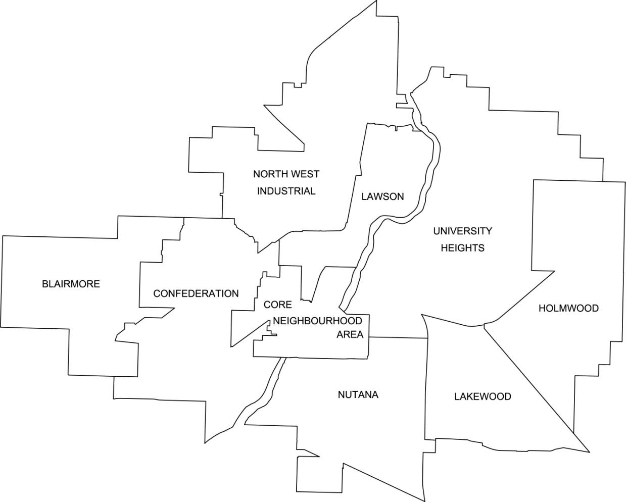
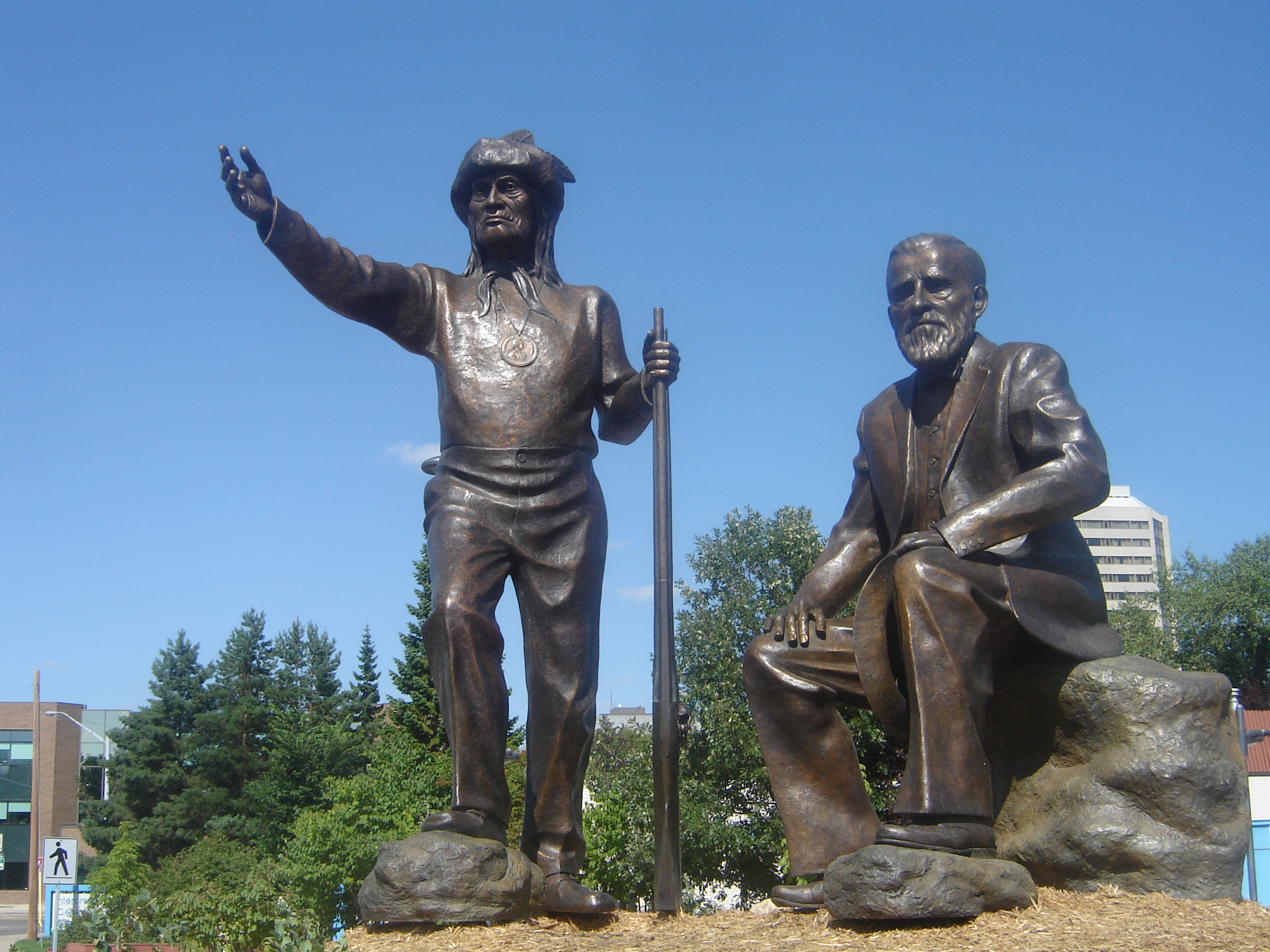
Nutana is a primarily residential neighbourhood located near the centre of Saskatoon, Saskatchewan, Canada. It includes the business district of Broadway Avenue. It comprises a nearly even mixture of low-density, single detached dwellings and apartment-style multiple unit dwellings. As of 2009, the area is home to 6,261 residents. The neighbourhood is considered a middle to upper-income area, with an average family income of $67,657, an average dwelling value of $206,830 and a home ownership rate of 51.3%. First established in 1883, Nutana was the original settlement of what now makes up the city of Saskatoon. History The first permanent settlement was established by the Temperance Colonization Society, a group of Toronto Methodists, under John Neilson Lake. The group moved into the area in 1883, a year after Lake and a scouting party had looked for a suitable colony site. The site chosen by Lake was on the suggestion of Chief Whitecap of the Dakota tribe. The land for the ... [...More Info...] [...Related Items...] OR: [Wikipedia] [Google] [Baidu] |
Core Neighbourhoods SDA, Saskatoon, Saskatchewan
The Core Neighbourhoods Suburban Development Area (SDA) is an area in Saskatoon, Saskatchewan, Canada. It is a part of the west and the east side community of Saskatoon, straddling the South Saskatchewan River. It lies (generally) south of the, east of Confederation SDA, to the west of Confederation SDA (west side) Lawson SDA (east side) University Heights SDA and north of (West side) Confederation SDA and (east side) Nutana SDA. This Suburban Development Area comprises early Saskatoon origins where the first towns of Nutana, West Saskatoon, and Riversdale came together to form the city of Saskatoon in 1906. Neighbourhoods East The east side of the Core Neighbourhoods Suburban Development Area (SDA) brings together the early Temperance Society colony which became later known as Nutana and Varsity View. Nutana was the first settled area on the east side of the South Saskatchewan River. With the beginnings of the University of Saskatchewan, Varsity View saw ra ... [...More Info...] [...Related Items...] OR: [Wikipedia] [Google] [Baidu] |
Central Business District, Saskatoon, Saskatchewan
The Central Business District is one of seven development districts in Saskatoon, Saskatchewan, Canada. The central business district is Ward 6 of a Mayor-Council government represented by councillor Cynthia Block. Formerly called West Saskatoon, this area arose when the steam engines built their pumping stations on the lower west bank of the South Saskatchewan River. Retail enterprises sprang up around the newly created train station and rail yards. The city of Saskatoon's Central Business District has shopping malls and boutiques. History In 1890 the Qu'Appelle, Long Lake and Saskatchewan Railway Line (QLLR) or The Qu'Appelle, Long Lake and Saskatchewan Steamboat and Railway Line (QLLSR) extended from Regina through to Prince Albert, crossing the South Saskatchewan River where the Senator Sid Buckwold Bridge crosses the river presently. Steam engines could be refilled easier on the west banks of the river which were not so steep. Businesses sprang up around the pumping statio ... [...More Info...] [...Related Items...] OR: [Wikipedia] [Google] [Baidu] |
List Of Neighbourhoods In Saskatoon
The city of Saskatoon, Saskatchewan, Canada currently has 65 neighbourhoods divided amongst 9 designated Suburban Development Areas (SDAs). Some neighbourhoods underwent boundary and name changes in the 1990s when the City of Saskatoon adjusted its community map. Definitions * Neighbourhood: the basic unit of residential development, comprehensively planned and maintained over the long term. Many older neighbourhoods were defined by elementary school catchment areas. The boundaries of some neighbourhoods were adjusted when the school boards no longer required students to live in their school catchment area. The boundaries of neighbourhoods are now defined by "natural" barriers such as major streets, railways, and bodies of water. * Suburban Development Area (SDA): a collection of neighbourhoods organized to facilitate long range planning for infrastructure and related community facilities. Each SDA has approximately ten neighbourhoods, 50,000 people, district and multi-district ... [...More Info...] [...Related Items...] OR: [Wikipedia] [Google] [Baidu] |
Saskatoon
Saskatoon () is the largest city in the Provinces and territories of Canada, Canadian province of Saskatchewan. It straddles a bend in the South Saskatchewan River in the central region of the province. It is located along the Trans-Canada Highway, Trans-Canada Yellowhead Highway, and has served as the cultural and economic hub of central Saskatchewan since its founding in 1882 as a Temperance movement, Temperance colony. With a Canada 2021 Census, 2021 census population of 266,141, Saskatoon is the List of cities in Saskatchewan, largest city in the province, and the List of census metropolitan areas and agglomerations in Canada, 17th largest Census Metropolitan Area in Canada, with a 2021 census population of 317,480. Saskatoon is home to the University of Saskatchewan, the Meewasin Valley Authority (which protects the South Saskatchewan River and provides for the city's popular riverbank park spaces), and Wanuskewin Heritage Park (a National Historic Site of Canada and UNES ... [...More Info...] [...Related Items...] OR: [Wikipedia] [Google] [Baidu] |
Traffic Bridge (Saskatoon)
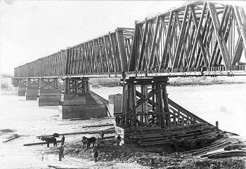
The Traffic Bridge is the name given to two truss bridges constructed across the South Saskatchewan River, connecting Victoria Avenue to 3rd Avenue South and Spadina Crescent in Saskatoon, Saskatchewan, Canada. The original bridge opened on October 10, 1907, and was the first bridge to carry motor vehicle traffic in Saskatoon, replacing an unreliable ferry service. The promised construction of the bridge was considered a prime factor in the amalgamation of the towns of Saskatoon, Nutana and Riversdale into one city named Saskatoon. The Traffic Bridge was the only road bridge in Saskatoon until 1916, when the University Bridge was completed. In 2010, the bridge was permanently closed due to severe corrosion and was demolished by 2016. A new truss bridge, a near-replica of the original except with fewer steel spans and a wider road bed, was constructed on the same site after the original bridge was closed. It opened on October 3, 2018. Names The bridge is known both popularly a ... [...More Info...] [...Related Items...] OR: [Wikipedia] [Google] [Baidu] |
Broadway Avenue (Saskatoon)
Broadway Avenue is an arterial road and commercial street in Saskatoon, Saskatchewan. It begins at the east end of the Broadway Bridge and continues south for about 4 kilometres until terminating at a cul-de-sac in the Avalon neighbourhood. The commercial portion, and the section usually referred to colloquially as "Broadway," is composed of the five blocks running south from the Broadway Bridge to 8th Street East, as well as the adjoining blocks east and west. This section makes up the Broadway Business Improvement District, and is a popular shopping and cultural destination of Saskatoon, featuring many restaurants and bars, boutique shops, local businesses, and annual street festivals, including the Saskatoon Fringe Theatre Festival. History This original portion of Broadway Avenue, between the bridge and 8th Street, was the original main commercial street of the town of Nutana, prior to amalgamation with Saskatoon in 1906. It was also the location of the city's first elementa ... [...More Info...] [...Related Items...] OR: [Wikipedia] [Google] [Baidu] |
Riversdale, Saskatoon
Riversdale is one of the oldest neighbourhoods in Saskatoon, Saskatchewan, Canada, located near the downtown area. It includes the business district of 20th Street. It consists mostly of low-density, single detached dwellings. As of 2021, the area was home to 2,534 residents. Riversdale has experienced an economic and development boom since 2012 and has even been called Canada's Next Great Neighbourhood. However, the neighbourhood is still considered a lower-income area, with (based on the 2016 Canadian Census) an estimated median personal income of $25,920, an estimated average dwelling value of $210,842 and an estimated home ownership rate of 45.5% According to MLS data, the average sale price of a home as of 2021 was $214,724. Incorporated as a town in 1905, Riversdale was one of the three original settlements that merged to form the city of Saskatoon in 1906. History The first record of settlement in the Riversdale area was in the 1890s, when the area was homesteaded. ... [...More Info...] [...Related Items...] OR: [Wikipedia] [Google] [Baidu] |
Prairieland Park
Prairieland Park is an events centre on the south-central edge of Saskatoon, Saskatchewan. The park is located in the Exhibition neighbourhood of Saskatoon. Each year the park hosts an annual Saskatoon Exhibition variably called "The Ex" (previously it was known as Pioneer Days). During the remainder of the year most of the park venues are rented out to special events. Some events held are Western Canadian Crop Production Show, Saskatchewan indemand trade show, Saskatoon Fall Fair cattle show and sale, Pet Expo, Chuckwagon Racing, and the Prairieland Junior Ag Showcase. The Agriculture Department is heavily involved in the community host 4H events. It currently hosts 321 events a year, which attracts 1.6 million people. The Ex The Ex is an annual fair that occurs on the site each August. This includes amusement rides, product exhibitions, music, shows and displays. Normally occurring at the same time are chuckwagon races at the Marquis downs facility. History The organ ... [...More Info...] [...Related Items...] OR: [Wikipedia] [Google] [Baidu] |
Cathy Sproule
Cathy Sproule is a Canadian politician, who was elected to the Legislative Assembly of Saskatchewan in the 2011 election. '''', November 8, 2011. She represented the electoral district of as a member of the Saskatchewan New Democratic Party
The Saskatchewan New Democratic Party (NDP) is a ...
[...More Info...] [...Related Items...] OR: [Wikipedia] [Google] [Baidu] |
City Park, Saskatoon
City Park is a mixed-use neighbourhood located near the center of Saskatoon, Saskatchewan, Canada. It comprises a mix of single-family detached homes, apartment buildings and other semi-detached dwellings. It also contains a number of commercial zones with businesses. As of 2009, the area was home to 4,405 residents. The neighbourhood is considered a middle-income area, with an average family income of $42,236, an average dwelling value of $245,254 and a home ownership rate of 28.6%. History City Park was originally known as Central Park and first had a golf course. In 1903, the annual exhibition was moved from the Louise Grounds in Nutana to City Park, and a horse racing track and grandstand were constructed. By 1910, the exhibition had moved to its permanent home in the city's south end. The outline of the old racetrack can still be seen in what is now Kinsmen Park. City Park was one of the first areas annexed by the city after its incorporation in 1906. The Alexander Resid ... [...More Info...] [...Related Items...] OR: [Wikipedia] [Google] [Baidu] |
Trounce House
Gustin House is a municipal and provincial designated historic building located in the Nutana neighborhood of Saskatoon, Saskatchewan, Canada. Trounce House, also a historic building, is located in the backyard of the Gustin House property. Gustin House is a 1920s style residential home with a special piano studio that connects to the main living room by sliding glass doors, permitting the use of the combined space for performances. In 1928 a back extension was constructed permitting a second rear piano studio to be added, the first remaining in the living room at the front of the house inside the veranda, with a library between the rooms. Dr Gustin's summer-class students also used the piano in Grace-Westminster United Church across the street at the corner of Eastlake Avenue—Westminster Church on 12th Street having closed in the mid-1960s. Built for Dr. Lyell Gustin (1895–1988), pianist and music teacher, the space was used to teach amateur and professional musicians over a ... [...More Info...] [...Related Items...] OR: [Wikipedia] [Google] [Baidu] |
Chief Whitecap
Chief Wapahaska ( fl. 1880s) ( dak, Wápaha Ská), also known as Chief Whitecap, was a Dakota chief from the area now known as Whitecap Dakota Reserve. Founding of Saskatoon John Lake of the Temperance Colonization Society of Toronto arrived in what is now Saskatoon in 1882 to survey the land. Whitecap advised that Lake begin the settlement on the east bank of the South Saskatchewan River, which would later become Nutana. Later life Whitecap was a participant in the North-West Rebellion The North-West Rebellion (french: Rébellion du Nord-Ouest), also known as the North-West Resistance, was a resistance by the Métis people under Louis Riel and an associated uprising by First Nations Cree and Assiniboine of the District of S ..., and was tried for treason after Louis Riel's surrender. He was later found not guilty. References {{reflist Dakota people 19th-century First Nations people First Nations history People of the North-West Rebellion Indigenous leaders in S ... [...More Info...] [...Related Items...] OR: [Wikipedia] [Google] [Baidu] |


