|
North Greenland Ice Core Project
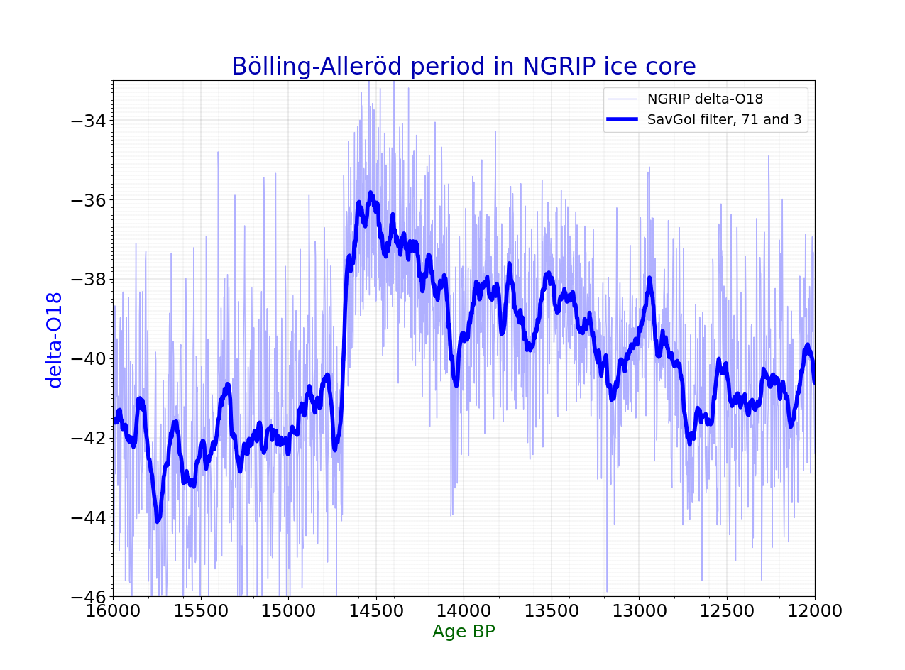
The drilling site of the North Greenland Ice Core Project (NGRIP or NorthGRIP) is near the center of Greenland (75.1 N, 42.32 W, 2917 m, ice thickness 3085). Drilling began in 1999 and was completed at bedrock in 2003. The cores are cylinders of ice 11 centimeters in diameter that were brought to the surface in 3.5-meter lengths. The NGRIP site was chosen to extract a long and undisturbed record stretching into the last glacial, and it succeeded. The site was chosen for a flat basal topography to avoid the flow distortions that render the bottom of the GRIP and GISP cores unreliable. Unusually, there is melting at the bottom of the NGRIP core - believed to be due to a high geothermal heat flux locally. This has the advantage that the bottom layers are less compressed by thinning than they would otherwise be: NGRIP annual layers at 10.5 kyr age are 1.1 cm thick, twice the GRIP thicknesses at equal age. The NGRIP record helps to resolve a problem with the GRIP and GISP2 r ... [...More Info...] [...Related Items...] OR: [Wikipedia] [Google] [Baidu] |
Eemian Stage
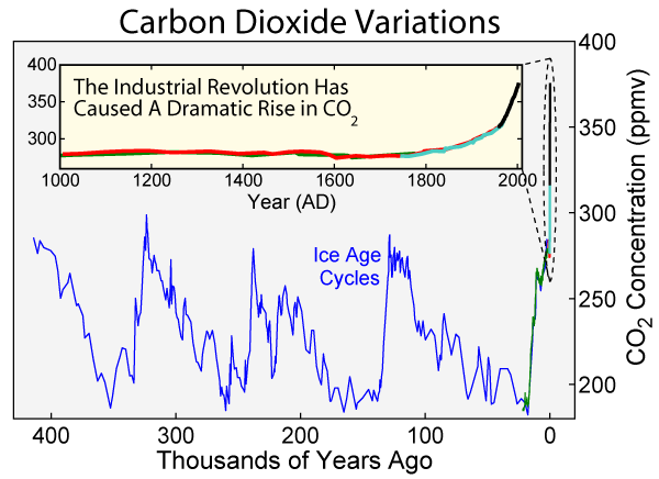
The Eemian (also called the last interglacial, Sangamonian Stage, Ipswichian, Mikulin, Kaydaky, penultimate,NOAA - Penultimate Interglacial Period http://www.ncdc.noaa.gov/global-warming/penultimate-interglacial-period Valdivia or Riss-Würm) was the interglacial period which began about 130,000 years ago at the end of the Penultimate Glacial Period and ended about 115,000 years ago at the beginning of the Last Glacial Period. It corresponds to Marine Isotope Stage 5e. Although sometimes referred to as the "last interglacial" (in the "most recent previous" sense of "last"), it was the second-to-latest interglacial period of the current Ice Age, the most recent being the Holocene which extends to the present day (having followed the last glacial period). The prevailing Eemian climate was, on average, around 1 to 2 degrees Celsius (1.8 to 3.6 Fahrenheit) warmer than that of the Holocene. During the Eemian, the proportion of in the atmosphere was about 280 parts per million. Th ... [...More Info...] [...Related Items...] OR: [Wikipedia] [Google] [Baidu] |
Arctic Research
Arctic studies may include: * Arctic ecology *Geology *Meteorology *Pedology *Oceanography See also * List of Arctic research programs * List of research stations in the Arctic A number of governments maintain permanent research stations in the Arctic. Also known as Arctic bases, polar stations or ice stations, these bases are widely distributed across the northern polar region of Earth. Historically few research st ... References Earth sciences Arctic research {{arctic-stub ... [...More Info...] [...Related Items...] OR: [Wikipedia] [Google] [Baidu] |
Natural History Of Greenland
Nature, in the broadest sense, is the physical world or universe. "Nature" can refer to the phenomena of the physical world, and also to life in general. The study of nature is a large, if not the only, part of science. Although humans are part of nature, human activity is often understood as a separate category from other natural phenomena. The word ''nature'' is borrowed from the Old French ''nature'' and is derived from the Latin word ''natura'', or "essential qualities, innate disposition", and in ancient times, literally meant "birth". In ancient philosophy, ''natura'' is mostly used as the Latin translation of the Greek word ''physis'' (φύσις), which originally related to the intrinsic characteristics of plants, animals, and other features of the world to develop of their own accord. The concept of nature as a whole, the physical universe, is one of several expansions of the original notion; it began with certain core applications of the word φύσις by pre-So ... [...More Info...] [...Related Items...] OR: [Wikipedia] [Google] [Baidu] |
Geochronological Institutions And Organizations
Geochronology is the science of determining the age of rocks, fossils, and sediments using signatures inherent in the rocks themselves. Absolute geochronology can be accomplished through radioactive isotopes, whereas relative geochronology is provided by tools such as paleomagnetism and stable isotope ratios. By combining multiple geochronological (and biostratigraphic) indicators the precision of the recovered age can be improved. Geochronology is different in application from biostratigraphy, which is the science of assigning sedimentary rocks to a known geological period via describing, cataloging and comparing fossil floral and faunal assemblages. Biostratigraphy does not ''directly'' provide an absolute age determination of a rock, but merely places it within an ''interval'' of time at which that fossil assemblage is known to have coexisted. Both disciplines work together hand in hand, however, to the point where they share the same system of naming strata (rock layers) and ... [...More Info...] [...Related Items...] OR: [Wikipedia] [Google] [Baidu] |
Greenlandian
In the geologic time scale, the Greenlandian is the earliest age or lowest stage of the Holocene Epoch or Series, part of the Quaternary. Beginning in 11,650 BP (9701 BCE or 300 HE) and ending 8,276 BP (6237 BCE or 3764 HE), it is the earliest of three sub-divisions of the Holocene. It was officially ratified by the International Commission on Stratigraphy in June 2018 with the later Northgrippian and Meghalayan Ages/Stages. The lower boundary of the Greenlandian Age is the GSSP sample from the North Greenland Ice Core Project in central Greenland (75.1000°N 42.3200°W). The Greenlandian GSSP has been correlated with the end of Younger Dryas The Younger Dryas (c. 12,900 to 11,700 years BP) was a return to glacial conditions which temporarily reversed the gradual climatic warming after the Last Glacial Maximum (LGM, c. 27,000 to 20,000 years BP). The Younger Dryas was the last stag ... (from near-glacial to interglacial) and a "shift in deuterium excess values". Refer ... [...More Info...] [...Related Items...] OR: [Wikipedia] [Google] [Baidu] |
Northgrippian
In the geologic time scale, the Northgrippian is the middle one of three ages or stages of the Holocene Epoch or Series. It was officially ratified by the International Commission on Stratigraphy in June 2018 along with the earlier Greenlandian and later Meghalayan ages/stages. The age takes its name from the North Greenland Ice Core Project (NorthGRIP). The age began 8,276 BP (6326 BCE or 3854 HE), near the 8.2-kiloyear event, and goes up to the start of the Meghalayan, which began 4,200 BP (2250 BCE or 7750 HE), near the 4.2-kiloyear event. See also * Geologic time scale * NorthGRIP The drilling site of the North Greenland Ice Core Project (NGRIP or NorthGRIP) is near the center of Greenland (75.1 N, 42.32 W, 2917 m, ice thickness 3085). Drilling began in 1999 and was completed at bedrock in 2003. The cores are cylinders ... * 5th millennium BC References 7th millennium BC *01 Geological epochs * *03 * {{geochronology-stub ... [...More Info...] [...Related Items...] OR: [Wikipedia] [Google] [Baidu] |
Sediment
Sediment is a naturally occurring material that is broken down by processes of weathering and erosion, and is subsequently transported by the action of wind, water, or ice or by the force of gravity acting on the particles. For example, sand and silt can be carried in suspension in river water and on reaching the sea bed deposited by sedimentation; if buried, they may eventually become sandstone and siltstone ( sedimentary rocks) through lithification. Sediments are most often transported by water ( fluvial processes), but also wind (aeolian processes) and glaciers. Beach sands and river channel deposits are examples of fluvial transport and deposition, though sediment also often settles out of slow-moving or standing water in lakes and oceans. Desert sand dunes and loess are examples of aeolian transport and deposition. Glacial moraine deposits and till are ice-transported sediments. Classification Sediment can be classified based on its grain size, grain s ... [...More Info...] [...Related Items...] OR: [Wikipedia] [Google] [Baidu] |
Holocene
The Holocene ( ) is the current geological epoch. It began approximately 11,650 cal years Before Present (), after the Last Glacial Period, which concluded with the Holocene glacial retreat. The Holocene and the preceding Pleistocene together form the Quaternary period. The Holocene has been identified with the current warm period, known as MIS 1. It is considered by some to be an interglacial period within the Pleistocene Epoch, called the Flandrian interglacial.Oxford University Press – Why Geography Matters: More Than Ever (book) – "Holocene Humanity" section https://books.google.com/books?id=7P0_sWIcBNsC The Holocene corresponds with the rapid proliferation, growth and impacts of the human species worldwide, including all of its written history, technological revolutions, development of major civilizations, and overall significant transition towards urban living in the present. The human impact on modern-era Earth and its ecosystems may be considered of global ... [...More Info...] [...Related Items...] OR: [Wikipedia] [Google] [Baidu] |
Geothermal (geology)
Geothermal gradient is the rate of temperature change with respect to increasing depth in Earth's interior. As a general rule, the crust temperature rises with depth due to the heat flow from the much hotter mantle; away from tectonic plate boundaries, temperature rises in about 25–30 °C/km (72–87 °F/mi) of depth near the surface in most of the world. However, in some cases the temperature may drop with increasing depth, especially near the surface, a phenomenon known as ''inverse'' or ''negative'' geothermal gradient. The effects of weather, sun, and season only reach a depth of approximately 10-20 metres. Strictly speaking, ''geo''-thermal necessarily refers to Earth but the concept may be applied to other planets. In SI units, the geothermal gradient is expressed as °C/km, K/km, or mK/m. These are all equivalent. Earth's internal heat comes from a combination of residual heat from planetary accretion, heat produced through radioactive decay, latent heat ... [...More Info...] [...Related Items...] OR: [Wikipedia] [Google] [Baidu] |


.jpg)


