|
Newham, Victoria
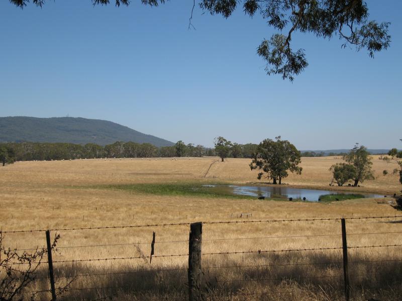
Newham () is a town in the Shire of Macedon Ranges in Victoria, Australia. It is situated between the towns of Kyneton, Woodend and Lancefield. At the 2006 census, the surrounding area had a population of 570. At the 2016 census, Newham and the surrounding area had a population of 506. History The township of Newham was occupied as a station in 1847 by settlers named Peters and Dryden and called Dryden's Rock; The district of Newham and Woodend was created in December 1861; it became the Shire of Newham and Woodend in January 1905. Newham Post Office opened on 16 September 1861 and closed in 1971. Possible origins of the name In 1848 it may have been named Newham after Rev. Newham, an Anglican priest. Around the 1850s, Newham was known variously as ''Hieland Town'' or ''Isle of Skye'', perhaps indicating a Scottish heritage of the early settlers. It would appear that these names were colloquial terms rather than official names. While it is likely that the town was named ... [...More Info...] [...Related Items...] OR: [Wikipedia] [Google] [Baidu] |
Electoral District Of Macedon
The electoral district of Macedon is an electoral district of the Victorian Legislative Assembly. It was created in 2002, replacing the abolished electorate of Gisborne. It was won at that election by Joanne Duncan, the former member for Gisborne. She was re-elected in 2006 and 2010, and retired at the 2014 election, at which she was succeeded by Labor candidate Mary-Anne Thomas. Members for Macedon Election results See also * Parliaments of the Australian states and territories * List of members of the Victorian Legislative Assembly {{{Use dmy dates, date=June 2015 {{Use Australian English, date=June 2015 The following are lists of members of the Victorian Legislative Assembly: * Members of the Victorian Legislative Assembly, 1856–1859 * Members of the Victorian Legislative ... References External links Electorate profile: Macedon District, Victorian Electoral Commission 2002 establishments in Australia Electoral districts of Victoria (Australia) Shire of Ma ... [...More Info...] [...Related Items...] OR: [Wikipedia] [Google] [Baidu] |
Victoria (Australia)
Victoria is a state in southeastern Australia. It is the second-smallest state with a land area of , the second most populated state (after New South Wales) with a population of over 6.5 million, and the most densely populated state in Australia (28 per km2). Victoria is bordered by New South Wales to the north and South Australia to the west, and is bounded by the Bass Strait to the south (with the exception of a small land border with Tasmania located along Boundary Islet), the Great Australian Bight portion of the Southern Ocean to the southwest, and the Tasman Sea (a marginal sea of the South Pacific Ocean) to the southeast. The state encompasses a range of climates and geographical features from its temperate coastal and central regions to the Victorian Alps in the northeast and the semi-arid north-west. The majority of the Victorian population is concentrated in the central-south area surrounding Port Phillip Bay, and in particular within the metropolit ... [...More Info...] [...Related Items...] OR: [Wikipedia] [Google] [Baidu] |
Newham Rural Fire Brigade
The Newham Fire Brigade is a volunteer firefighting service located in Newham, Victoria at 1293 Rochford Road. The brigade is often referred to as the Newham CFA and was formerly known as the Newham Rural Fire Brigade. The brigade is part of the Mount Macedon Group in the Lodden-Mallee Region of the Country Fire Authority. Newham is located in the Macedon Ranges, which is one of Victoria's popular holiday spots and has a risk of bushfire during the summer months. Since its beginnings in the 1930s, the Newham community has developed the brigade's modern firefighting operations in a history that typifies the CFA's volunteerism. History In 1936 four Newham residents were among the volunteers who joined in the formation of the Woodend Bush Fire Brigade. These first volunteers were W. A. Crozier, W Campbell, A. B. Trewhalla and W. J. Muir. On 19 March 1957, a public meeting elected officers to form a Newham branch of the Woodend Rural Fire Brigade. Funds were raised for the original a ... [...More Info...] [...Related Items...] OR: [Wikipedia] [Google] [Baidu] |
Bluestone
Bluestone is a cultural or commercial name for a number of dimension or building stone varieties, including: * basalt in Victoria, Australia, and in New Zealand * dolerites in Tasmania, Australia; and in Britain (including Stonehenge) * feldspathic sandstone in the US and Canada * limestone in the Shenandoah Valley in the US, from the Hainaut quarries in Soignies, Belgium, and from quarries in County Carlow, County Galway and County Kilkenny in Ireland * slate in South Australia Stonehenge The term "bluestone" in Britain is used in a loose sense to cover all of the "foreign," not intrinsic, stones and rock debris at Stonehenge. It is a "convenience" label rather than a geological term, since at least 46 different rock types are represented. One of the most common rocks in the assemblage is known as Preseli Spotted Dolerite—a chemically altered igneous rock containing spots or clusters of secondary minerals replacing plagioclase feldspar. It is a medium grained dark and ... [...More Info...] [...Related Items...] OR: [Wikipedia] [Google] [Baidu] |
Hanging Rock, Victoria
Hanging Rock (also known as Mount Diogenes, Dryden's Rock,Stephanie Skidmore & Ian D. Clark (2014) "Hanging Rock Recreation Reserve", In''An Historical Geography of Tourism in Victoria, Australia: Case Studies'' Ian D. Clarke ed., De Gruyter Open Ltd: Warsaw/Berlin, pp. 111-134. and to some of its traditional owners as Ngannelong) is a distinctive geological formation in central Victoria, Australia. A former volcano, it lies 718 m above sea level (105 m above plain level) on the plain between the two small townships of Newham and Hesket, approximately 70 km north-west of Melbourne and a few kilometres north of Mount Macedon. In the middle of the 19th century, the traditional occupants of the place – tribes of the Dja Dja Wurrung, Woi Wurrung and Taungurung – were forced from it. They had been its occupants for thousands of years and, colonisation notwithstanding, have continued to maintain cultural and spiritual connections with the place. To the settler co ... [...More Info...] [...Related Items...] OR: [Wikipedia] [Google] [Baidu] |
Newham Church
The London Borough of Newham is a London borough created in 1965 by the London Government Act 1963. It covers an area previously administered by the Essex county boroughs of West Ham and East Ham, authorities that were both abolished by the same act. The name Newham reflects its creation and combines the compass points of the old borough names. Situated in the East London part of Inner London, Newham has a population of 387,576, which is the third highest of the London boroughs and also makes it the 17th most populous district in England. The local authority is Newham London Borough Council. It is east of the City of London, north of the River Thames (the Woolwich Ferry and Woolwich foot tunnel providing the only crossings to the south), bounded by the River Lea to its west and the North Circular Road to its east. Newham was one of the six host boroughs for the 2012 Summer Olympics and contains most of the Olympic Park including the London Stadium, and also contains the Lond ... [...More Info...] [...Related Items...] OR: [Wikipedia] [Google] [Baidu] |
Greater Manchester
Greater Manchester is a metropolitan county and combined authority, combined authority area in North West England, with a population of 2.8 million; comprising ten metropolitan boroughs: City of Manchester, Manchester, City of Salford, Salford, Metropolitan Borough of Bolton, Bolton, Metropolitan Borough of Bury, Bury, Metropolitan Borough of Oldham, Oldham, Metropolitan Borough of Rochdale, Rochdale, Metropolitan Borough of Stockport, Stockport, Tameside, Trafford and Metropolitan Borough of Wigan, Wigan. The county was created on 1 April 1974, as a result of the Local Government Act 1972, and designated a functional Manchester City Region, city region on 1 April 2011. Greater Manchester is formed of parts of the Historic counties of England, historic counties of Cheshire, Lancashire and the West Riding of Yorkshire. Greater Manchester spans , which roughly covers the territory of the Greater Manchester Built-up Area, the List of urban areas in the United Kingdom, second most ... [...More Info...] [...Related Items...] OR: [Wikipedia] [Google] [Baidu] |
Oldham
Oldham is a large town in Greater Manchester, England, amid the Pennines and between the rivers Irk and Medlock, southeast of Rochdale and northeast of Manchester. It is the administrative centre of the Metropolitan Borough of Oldham, which had a population of 237,110 in 2019. Within the boundaries of the historic county of Lancashire, and with little early history to speak of, Oldham rose to prominence in the 19th century as an international centre of textile manufacture. It was a boomtown of the Industrial Revolution, and among the first ever industrialised towns, rapidly becoming "one of the most important centres of cotton and textile industries in England." At its zenith, it was the most productive cotton spinning mill town in the world,. producing more cotton than France and Germany combined. Oldham's textile industry fell into decline in the mid-20th century; the town's last mill closed in 1998. The demise of textile processing in Oldham depressed and heavily ... [...More Info...] [...Related Items...] OR: [Wikipedia] [Google] [Baidu] |
England
England is a country that is part of the United Kingdom. It shares land borders with Wales to its west and Scotland to its north. The Irish Sea lies northwest and the Celtic Sea to the southwest. It is separated from continental Europe by the North Sea to the east and the English Channel to the south. The country covers five-eighths of the island of Great Britain, which lies in the North Atlantic, and includes over 100 smaller islands, such as the Isles of Scilly and the Isle of Wight. The area now called England was first inhabited by modern humans during the Upper Paleolithic period, but takes its name from the Angles, a Germanic tribe deriving its name from the Anglia peninsula, who settled during the 5th and 6th centuries. England became a unified state in the 10th century and has had a significant cultural and legal impact on the wider world since the Age of Discovery, which began during the 15th century. The English language, the Anglican Church, and Engli ... [...More Info...] [...Related Items...] OR: [Wikipedia] [Google] [Baidu] |
Northumberland
Northumberland () is a county in Northern England, one of two counties in England which border with Scotland. Notable landmarks in the county include Alnwick Castle, Bamburgh Castle, Hadrian's Wall and Hexham Abbey. It is bordered by land on three sides; by the Scottish Borders region to the north, County Durham and Tyne and Wear to the south, and Cumbria to the west. The fourth side is the North Sea, with a stretch of coastline to the east. A predominantly rural county with a landscape of moorland and farmland, a large area is part of Northumberland National Park. The area has been the site of a number of historic battles with Scotland. Name The name of Northumberland is recorded as ''norð hẏmbra land'' in the Anglo-Saxon Chronicle, meaning "the land north of the Humber". The name of the kingdom of ''Northumbria'' derives from the Old English meaning "the people or province north of the Humber", as opposed to the people south of the Humber Estuary. History ... [...More Info...] [...Related Items...] OR: [Wikipedia] [Google] [Baidu] |


