|
New Zealand State Highway 23
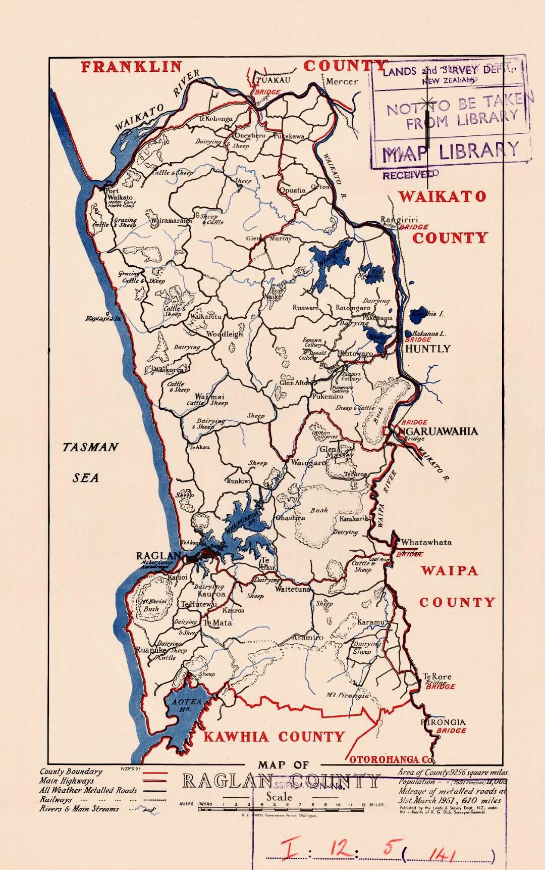
State Highway 23 (SH 23) is a New Zealand state highway that connects the towns of Raglan and Hamilton. Route SH 23 commences in the Hamilton suburb of Frankton at the intersection of Massey Street and (Lincoln Street, Greenwood Street). It travels west down Massey Street, changing to Whatawhata Road after a six-leg roundabout in the suburb of Dinsdale. After exiting Hamilton, and reaching the town of Whatawhata it shares a brief concurrency of the north–south and crosses the Waipā River. It then continues west over the summit to the Waitetuna valley, through Te Uku and over tributaries of the Whaingaroa Harbour until reaching Raglan. The route terminates on the approach to Raglan at a point approximately west of Greenslade Road. Traffic flows Average annual daily traffic records taken by the NZ Transport Agency measures the volume of traffic is measured at roughly 13,000 vehicles per day near the eastern terminus while at km 32 closer to Raglan the AADT is ... [...More Info...] [...Related Items...] OR: [Wikipedia] [Google] [Baidu] |
Frankton, Hamilton
Frankton is a central suburb of the city of Hamilton, New Zealand. It is the site of the city's passenger railway station, a major industrial-commercial stretch of State Highway 1, and a commercial shopping area. Frankton Borough Council was formed in 1913, but merged with Hamilton in 1917, after a poll in 1916. Demographics Frankton covers and had an estimated population of as of with a population density of people per km2. Frankton had a population of 6,504 at the 2018 New Zealand census, an increase of 1,335 people (25.8%) since the 2013 census, and an increase of 1,716 people (35.8%) since the 2006 census. There were 2,319 households, comprising 3,207 males and 3,312 females, giving a sex ratio of 0.97 males per female, with 1,473 people (22.6%) aged under 15 years, 1,902 (29.2%) aged 15 to 29, 2,628 (40.4%) aged 30 to 64, and 507 (7.8%) aged 65 or older. Ethnicities were 54.1% European/Pākehā, 35.7% Māori, 9.9% Pacific peoples, 17.7% Asian, and 3.0% other ethni ... [...More Info...] [...Related Items...] OR: [Wikipedia] [Google] [Baidu] |
Waikato Regional Council
Waikato () is a local government region of the upper North Island of New Zealand. It covers the Waikato District, Waipa District, Matamata-Piako District, South Waikato District and Hamilton City, as well as Hauraki, Coromandel Peninsula, the northern King Country, much of the Taupō District, and parts of Rotorua District. It is governed by the Waikato Regional Council. The region stretches from Coromandel Peninsula in the north, to the north-eastern slopes of Mount Ruapehu in the south, and spans the North Island from the west coast, through the Waikato and Hauraki to Coromandel Peninsula on the east coast. Broadly, the extent of the region is the Waikato River catchment. Other major catchments are those of the Waihou, Piako, Awakino and Mokau rivers. The region is bounded by Auckland on the north, Bay of Plenty on the east, Hawke's Bay on the south-east, and Manawatū-Whanganui and Taranaki on the south. Waikato Region is the fourth largest region in the country in a ... [...More Info...] [...Related Items...] OR: [Wikipedia] [Google] [Baidu] |
Waingaro
Waingaro is a rural community in the Waikato District and Waikato region of New Zealand's North Island, on the banks of the Waingaro River, where it is fed by a hot spring. Demographics Waingaro is in an SA1 statistical area which covers . The SA1 area is part of the larger Te Ākau statistical area. Waingaro had a population of 180 at the 2018 New Zealand census, an increase of 33 people (22.4%) since the 2013 census, and an increase of 6 people (3.4%) since the 2006 census. There were 63 households, comprising 99 males and 81 females, giving a sex ratio of 1.22 males per female. The median age was 47.3 years (compared with 37.4 years nationally), with 21 people (11.7%) aged under 15 years, 30 (16.7%) aged 15 to 29, 99 (55.0%) aged 30 to 64, and 33 (18.3%) aged 65 or older. Ethnicities were 71.7% European/Pākehā, and 45.0% Māori. People may identify with more than one ethnicity. Although some people chose not to answer the census's question about religious affiliati ... [...More Info...] [...Related Items...] OR: [Wikipedia] [Google] [Baidu] |
Ngāruawāhia
Ngāruawāhia () is a town in the Waikato region of the North Island of New Zealand. It is located north-west of Hamilton at the confluence of the Waikato and Waipā Rivers, adjacent to the Hakarimata Range. Ngāruawāhia is in the Hamilton Urban Area, the fourth largest urban area in New Zealand. The location was once considered as a potential capital of New Zealand. Demographics Ngāaruawāhia covers and had an estimated population of as of with a population density of people per km2. Ngāruawāhia had slightly smaller boundaries in the 2018 Census, covering . It had a population of 6,621, an increase of 1,257 people (23.4%) since the 2013 census, and an increase of 1,287 people (24.1%) since the 2006 census. There were 1,962 households, comprising 3,234 males and 3,384 females, giving a sex ratio of 0.96 males per female, with 1,914 people (28.9%) aged under 15 years, 1,434 (21.7%) aged 15 to 29, 2,661 (40.2%) aged 30 to 64, and 606 (9.2%) aged 65 or older. Ethniciti ... [...More Info...] [...Related Items...] OR: [Wikipedia] [Google] [Baidu] |
Ōtorohanga
Ōtorohanga is a north King Country town in the Waikato region in the North Island of New Zealand. It is located south of Hamilton and north of Te Kūiti, on the Waipā River. It is a service town for the surrounding dairy-farming district. It is recognised as the "gateway" to the Waitomo Caves and as the "Kiwiana Town" of New Zealand. Until 2007, Ōtorohanga held a yearly 'Kiwiana Festival.' History Early history Until the 1860s Ōtorohanga was a Ngāti Maniapoto village, with several whare (houses), peach trees and a flour mill. Huipūtea is a 300-year-old kahikatea tree, just to the south east of Ōtorohanga, which was the site of a skirmish in 1822 between Ngāti Maniapoto and Ngāpuhi. The village was abandoned after the invasion of the Waikato, except for Lewis Hettit's (or Hetet) farm. The area remained insecure, with Hettit's store being robbed by Te Kooti in 1869, but a meeting with Donald McLean later that year signalled moves towards peace. John William Ell ... [...More Info...] [...Related Items...] OR: [Wikipedia] [Google] [Baidu] |
Pirongia
Pirongia is a small town in the Waipa District of the Waikato region of New Zealand's North Island. It is 12 kilometres to the west of Te Awamutu, on the banks of the Waipā River, close to the foot of the 962 metre Mount Pirongia, which lies in Pirongia Forest Park to the west of the town. Pirongia was originally named Alexandra, after the English Princess of Wales, but to avoid confusion with the town of that name in the South Island the name was changed to Pirongia. Some of the village's businesses and organisations such as the Alexandra Hotel and the Alexandra Racing Club retain the earlier name. Alexandra Racing Club, established in 1866, is reputed to be the second oldest racing club in New Zealand. History Early history At the northern end of the town, between the Waipā River and the Mangapiko Stream, is the site of Mātakitaki pā. This was the location of a Māori battle in May 1822 between invading musket-armed Ngāpuhi led by Hongi Hika and defending Waikato le ... [...More Info...] [...Related Items...] OR: [Wikipedia] [Google] [Baidu] |
Waikato District
Waikato District is a territorial authority of New Zealand, in the northern part of Waikato region, North Island. Waikato District is administered by the Waikato District Council, with headquarters in Ngāruawāhia. The district is centred to the north and west of the city of Hamilton, and takes in much of the northern Waikato Plains and also the Hakarimata Range. The north of the district contains swampy floodplain of the Waikato River and several small lakes, of which the largest is Lake Waikare. Other than Ngāruawāhia, the main population centres are Huntly, Raglan, and Te Kauwhata. The main industries in the district are dairy farming, forestry, and coal mining. There is a major coal-fired power station at Huntly. Te Kauwhata is at the centre of a major wine region. Demographics At the 2006 census the district had a population of 43,959. Of these, 6834 lived in Huntly, 5106 in Ngāruawāhia, 2637 in Raglan, and 1294 in Te Kauwhata. In 2010, the district acquired part o ... [...More Info...] [...Related Items...] OR: [Wikipedia] [Google] [Baidu] |
Auckland
Auckland (pronounced ) ( mi, Tāmaki Makaurau) is a large metropolitan city in the North Island of New Zealand. The List of New Zealand urban areas by population, most populous urban area in the country and the List of cities in Oceania by population, fifth largest city in Oceania, Auckland has an urban population of about It is located in the greater Auckland Region—the area governed by Auckland Council—which includes outlying rural areas and the islands of the Hauraki Gulf, and which has a total population of . While European New Zealanders, Europeans continue to make up the plurality of Auckland's population, the city became multicultural and Cosmopolitanism, cosmopolitan in the late-20th century, with Asian New Zealanders, Asians accounting for 31% of the city's population in 2018. Auckland has the fourth largest Foreign born, foreign-born population in the world, with 39% of its residents born overseas. With its large population of Pasifika New Zealanders, the city is ... [...More Info...] [...Related Items...] OR: [Wikipedia] [Google] [Baidu] |
Territorial Authority
Territorial authorities are the second tier of local government in New Zealand, below regional councils. There are 67 territorial authorities: 13 city councils, 53 district councils and the Chatham Islands Council. District councils serve a combination of rural and urban communities, while city councils administer the larger urban areas.City councils serve a population of more than 50,000 in a predominantly urban area. Five territorial authorities (Auckland, Nelson, Gisborne, Tasman and Marlborough) also perform the functions of a regional council and thus are unitary authorities. The Chatham Islands Council is a ''sui generis'' territorial authority that is similar to a unitary authority. Territorial authority districts are not subdivisions of regions, and some of them fall within more than one region. Regional council areas are based on water catchment areas, whereas territorial authorities are based on community of interest and road access. Regional councils are responsib ... [...More Info...] [...Related Items...] OR: [Wikipedia] [Google] [Baidu] |
Road Surface
A road surface (British English), or pavement (American English), is the durable surface material laid down on an area intended to sustain vehicular or foot traffic, such as a road or walkway. In the past, gravel road surfaces, hoggin, cobblestone and granite setts were extensively used, but these have mostly been replaced by asphalt or concrete laid on a compacted base course. Asphalt mixtures have been used in pavement construction since the beginning of the 20th century and are of two types: metalled (hard-surfaced) and unmetalled roads. Metalled roadways are made to sustain vehicular load and so are usually made on frequently used roads. Unmetalled roads, also known as gravel roads, are rough and can sustain less weight. Road surfaces are frequently marked to guide traffic. Today, permeable paving methods are beginning to be used for low-impact roadways and walkways. Pavements are crucial to countries such as United States and Canada, which heavily depend on road transpor ... [...More Info...] [...Related Items...] OR: [Wikipedia] [Google] [Baidu] |
Stagecoach
A stagecoach is a four-wheeled public transport coach used to carry paying passengers and light packages on journeys long enough to need a change of horses. It is strongly sprung and generally drawn by four horses although some versions are drawn by six horses. Commonly used before steam-powered rail transport was available, a stagecoach made long scheduled trips using ''stage stations'' or posts where the stagecoach's horses would be replaced by fresh horses. The business of running stagecoaches or the act of journeying in them was known as staging. Some familiar images of the stagecoach are that of a Royal Mail coach passing through a turnpike gate, a Dickensian passenger coach covered in snow pulling up at a coaching inn, a highwayman demanding a coach to "stand and deliver" and a Wells Fargo stagecoach arriving at or leaving a Wild West town. The yard of ale drinking glass is associated by legend with stagecoach drivers, though it was mainly used for drinking feats and ... [...More Info...] [...Related Items...] OR: [Wikipedia] [Google] [Baidu] |


_p225_AUCKLAND%2C_NEW_ZEALAND.jpg)

.jpg)