|
Nyamapanda
Nyamapanda (Other names: Nyamapande, Nyamapanda Customs Post) is a town in the Mashonaland East Province of northern Zimbabwe. It is a border post for crossing between Zimbabwe and Mozambique Mozambique (), officially the Republic of Mozambique ( pt, Moçambique or , ; ny, Mozambiki; sw, Msumbiji; ts, Muzambhiki), is a country located in southeastern Africa bordered by the Indian Ocean to the east, Tanzania to the north, Malawi .... The border post on the Mozambique side is Cochemane. Nyamapanda is at an altitude of . A dam on the Nyamapande River (Inyapandi River) just upstream from the town provides for irrigation. Notes Populated places in Mashonaland East Province {{Zimbabwe-geo-stub ... [...More Info...] [...Related Items...] OR: [Wikipedia] [Google] [Baidu] |
Mashonaland East Province
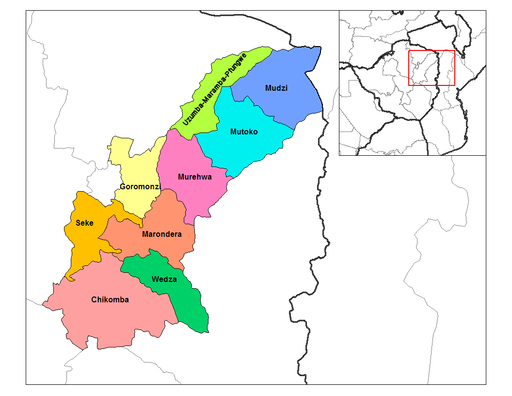
Mashonaland East, informally Mash East, is a province of Zimbabwe. It has an area of 32,230 km2 and a population of approximately 1.35 million (2012). Marondera is the capital of the province. Geography Districts Mashonaland East is divided into nine districts: * Chikomba * Goromonzi * Marondera * Mudzi * Murehwa (Mrehwa) * Mutoko * Seke * Uzumba-Maramba-Pfungwe (UMP) * Wedza (Hwedza) Education See also * Provinces of Zimbabwe * Districts of Zimbabwe The Republic of Zimbabwe is broken down into 10 administrative provinces, which are divided into 59 districts and 1,200 wards. Bulawayo Province * Bulawayo Harare Province * Harare Manicaland Province * Buhera * Chi ... Notes External links * Provinces of Zimbabwe {{Zimbabwe-gov-stub ... [...More Info...] [...Related Items...] OR: [Wikipedia] [Google] [Baidu] |
Zimbabwe
Zimbabwe (), officially the Republic of Zimbabwe, is a landlocked country located in Southeast Africa, between the Zambezi and Limpopo Rivers, bordered by South Africa to the south, Botswana to the south-west, Zambia to the north, and Mozambique to the east. The capital and largest city is Harare. The second largest city is Bulawayo. A country of roughly 15 million people, Zimbabwe has 16 official languages, with English, Shona language, Shona, and Northern Ndebele language, Ndebele the most common. Beginning in the 9th century, during its late Iron Age, the Bantu peoples, Bantu people (who would become the ethnic Shona people, Shona) built the city-state of Great Zimbabwe which became one of the major African trade centres by the 11th century, controlling the gold, ivory and copper trades with the Swahili coast, which were connected to Arab and Indian states. By the mid 15th century, the city-state had been abandoned. From there, the Kingdom of Zimbabwe was established, fol ... [...More Info...] [...Related Items...] OR: [Wikipedia] [Google] [Baidu] |
National Geospatial-Intelligence Agency
The National Geospatial-Intelligence Agency (NGA) is a combat support agency within the United States Department of Defense whose primary mission is collecting, analyzing, and distributing geospatial intelligence (GEOINT) in support of national security. Initially known as the National Imagery and Mapping Agency (NIMA) from 1996 to 2003, it is a member of the United States Intelligence Community. NGA headquarters, also known as NGA Campus East or NCE, is located at Fort Belvoir North Area in Springfield, Virginia. The agency also operates major facilities in the St. Louis, Missouri area (referred to as NGA Campus West or NCW), as well as support and liaison offices worldwide. The NGA headquarters, at , is the third-largest government building in the Washington metropolitan area after The Pentagon and the Ronald Reagan Building. In addition to using GEOINT for U.S. military and intelligence efforts, NGA provides assistance during natural and man-made disasters, aids in security ... [...More Info...] [...Related Items...] OR: [Wikipedia] [Google] [Baidu] |
Mozambique
Mozambique (), officially the Republic of Mozambique ( pt, Moçambique or , ; ny, Mozambiki; sw, Msumbiji; ts, Muzambhiki), is a country located in southeastern Africa bordered by the Indian Ocean to the east, Tanzania to the north, Malawi and Zambia to the northwest, Zimbabwe to the west, and Eswatini and South Africa to the southwest. The sovereign state is separated from the Comoros, Mayotte and Madagascar by the Mozambique Channel to the east. The capital and largest city is Maputo. Notably Northern Mozambique lies within the monsoon trade winds of the Indian Ocean and is frequentely affected by disruptive weather. Between the 7th and 11th centuries, a series of Swahili port towns developed on that area, which contributed to the development of a distinct Swahili culture and language. In the late medieval period, these towns were frequented by traders from Somalia, Ethiopia, Egypt, Arabia, Persia, and India. The voyage of Vasco da Gama in 1498 marked the arrival of t ... [...More Info...] [...Related Items...] OR: [Wikipedia] [Google] [Baidu] |

