|
Numansdorp
Numansdorp is a town and former municipality in the province South Holland in the Netherlands and is located on the island Hoeksche Waard near the Hollands Diep. On 1 January 1984, the municipalities Numansdorp and Klaaswaal were merged into one municipality called Cromstrijen. Cromstrijen was merged into the new municipality Hoeksche Waard in January 2019. History Numansdorp was founded in 1642. The village was built in the Numanspolder. It took a while till the embankment of this polder was started. The reason for the delay was a disagreement between the Lords of Cromstrijen and the owners of Zuid-Beijerland. When the founding of the village had finally taken place, it still didn't have an official name, even though the locals called it Buitensluis. In a meeting it was decided to call the village "Village of Cromstrijen" (Dorp van Cromstrijen). But Dijkgraaf Vos, the chairman of the meeting, believed the village should me named after the first Ambachtsheer, Gerard Numan. ... [...More Info...] [...Related Items...] OR: [Wikipedia] [Google] [Baidu] |
Hoeksche Waard
The Hoekse Waard (; pre-1947 spelling: Hoeksche Waard) is an island between the Oude Maas, Dordtsche Kil, Hollands Diep, Haringvliet and Spui rivers in the province of South Holland in the Netherlands. The island, part of the namesake municipality of Hoeksche Waard, is a mostly agricultural region, south of the outskirts of Rotterdam. The Hoeksche Waard consists of reclaimed land (polders): after the Saint Elisabeth flood of 1421 most of the area was flooded. The land has been reclaimed gradually in the following centuries. Former municipalities The Hoeksche Waard formerly consisted of the following municipalities until these were merged on 1 January 2019: * Binnenmaas (villages Blaaksedijk, Heinenoord, Goidschalxoord, Maasdam, Mijnsheerenland, Puttershoek, Westmaas and 's-Gravendeel) * Cromstrijen (villages Klaaswaal and Numansdorp) * Korendijk (villages Goudswaard, Nieuw-Beijerland, Piershil and Zuid-Beijerland, and the island of Tiengemeten) * Oud-Beijerland * Str ... [...More Info...] [...Related Items...] OR: [Wikipedia] [Google] [Baidu] |
Hollands Diep
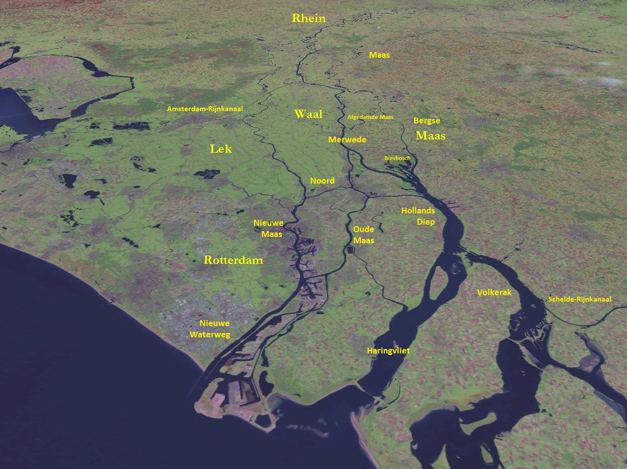
Hollands Diep ( pre-1947 spelling: Hollandsch Diep) is a wide river in the Netherlands and an estuary of the Rhine and Meuse rivers. Through the Scheldt-Rhine Canal it connects to the Scheldt river and Antwerp. The Bergse Maas river and the Nieuwe Merwede river join near Lage Zwaluwe to form the Hollands Diep. The Dordtsche Kil connects to it near Moerdijk. Near Numansdorp it splits into the Haringvliet and the Volkerak. History The Hollands Diep was formed as a result of the extensive flood of 1216, which breached the dunes of Voorne-Putten, Voorne and created a deep saltwater inlet (the current Haringvliet). During a second flood, the St. Elizabeth floods, this inlet connected to the Merwede and became an important estuary of the Rhine and Meuse rivers. From that moment on, the freshwater part of the estuary (east of the Hellegatsplein) was renamed Hollands Diep. The former river Striene, that used to connect the Meuse with the Scheldt The Scheldt (french: Escaut ; nl ... [...More Info...] [...Related Items...] OR: [Wikipedia] [Google] [Baidu] |
Hoeksche Waard (municipality)
Hoeksche Waard () is a municipality in the western Netherlands, in the province of South Holland, consisting of the eponymous Hoeksche Waard and Tiengemeten islands. The municipality was formed on 1 January 2019 by the merger of the municipalities Binnenmaas, Cromstrijen, Korendijk, Oud-Beijerland, and Strijen. Gallery File:'s-Gravendeel, de Kerk op de Heul GM1963-WN13 IMG 0979 2021-09-06 17.30.jpg, 's-Gravendeel, church: the Kerk op de Heul File:'s-Gravendeel, korenmolen het Vliegend Hert RM17406 foto3 2014-04-14 17.10.jpg, 's-Gravendeel, windmill: korenmolen het Vliegend Hert File:Westmaas, de Nederlands Hervormde kerk RM38856 IMG 0929 2021-09-06 13.38.jpg, Westmaas, reformed church File:Klaaswaal, de Nederlands Hervormde kerk RM23662 IMG 0941 2021-09-06 14.04.jpg, Klaaswaal, reformed church File:Strijen, de Grote- of Sint Lambertuskerk RM34945 IMG 0960 2021-09-06 16.04.jpg, Strijen, church: the Grote- or Sint Lambertuskerk File:Maasdam, de Kerk GM1963-WN24 IMG 0978 2021 ... [...More Info...] [...Related Items...] OR: [Wikipedia] [Google] [Baidu] |
Cromstrijen
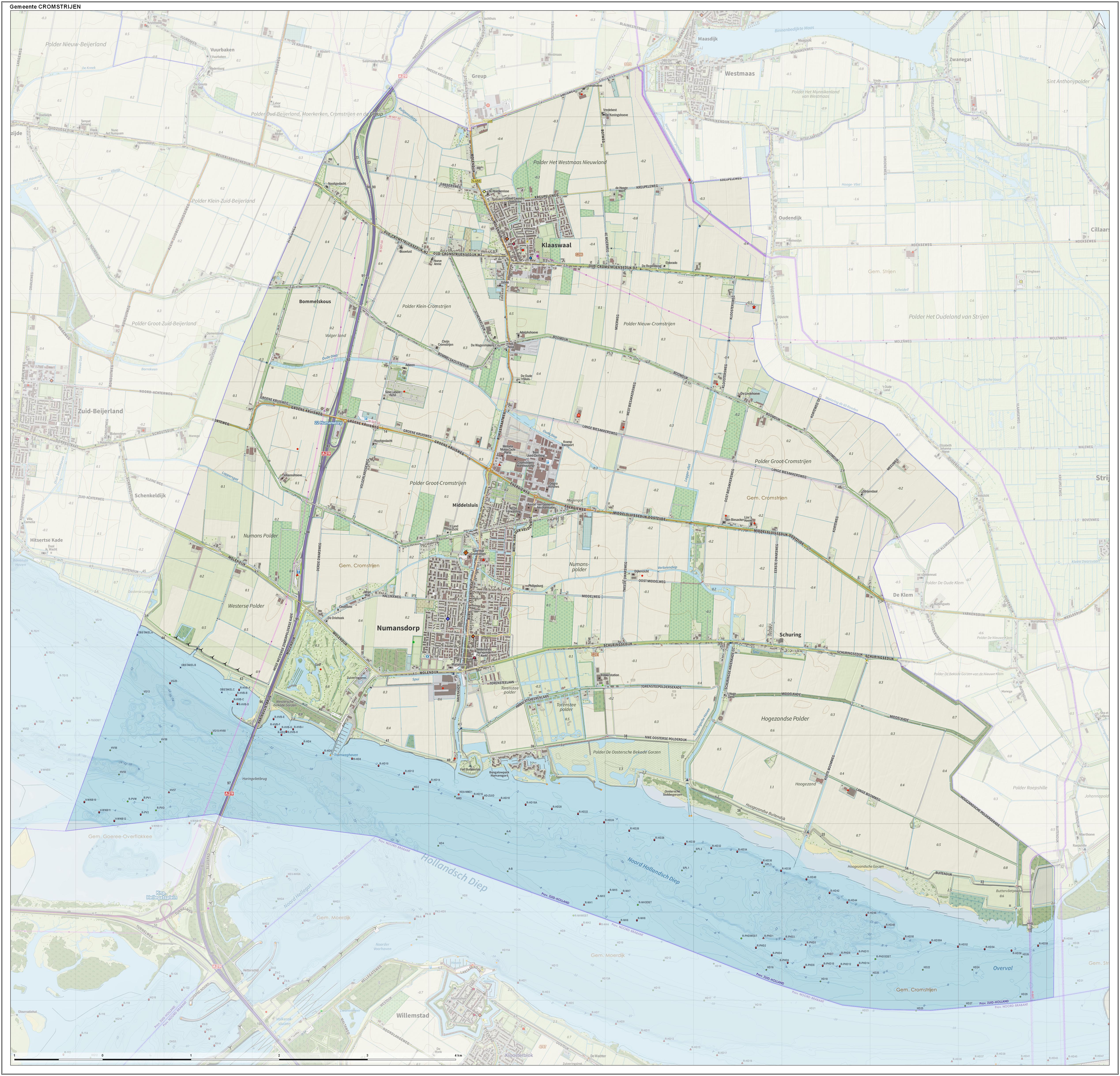
Cromstrijen (; ''Cromstrien'' in local dialect) was a municipality on the Hoeksche Waard Island in the western Netherlands, in the province of South Holland. The municipality covers an area of of which is water. It was formed on 1 January 1984, when the municipalities on the Hoeksche Waard were merged into larger municipalities. On 1 January 2019 it was merged with the municipalities of Binnenmaas, Korendijk, Oud-Beijerland, and Strijen to form the municipality of Hoeksche Waard The Hoekse Waard (; pre-1947 spelling: Hoeksche Waard) is an island between the Oude Maas, Dordtsche Kil, Hollands Diep, Haringvliet and Spui rivers in the province of South Holland in the Netherlands. The island, part of the namesake munic .... The municipality of Cromstrijen consists of the communities Klaaswaal and Numansdorp (townhall). Its population was in . Topography ''Dutch topographic map of the municipality of Cromstrijen, June 2015'' See also References External linksO ... [...More Info...] [...Related Items...] OR: [Wikipedia] [Google] [Baidu] |
Klaaswaal
Klaaswaal is a village and former municipality in the Dutch province of South Holland. It is centrally located on one of the island Hoeksche Waard. Klaaswaal was a separate municipality until 1984, when it was merged with Numansdorp to form the municipality Cromstrijen. History The village was first mentioned in 1555 as "Claes Wael", and means "pool after dike breach belonging to Claes (person)". In 1539 embankment of the polder ''Het Westmaas Nieuwland'' was started. The lords reserved a part of the new land for the new to found village ''Claeswaal''. The first buildings were built along the Voorstraat. At the end of this street, a church was built in 1566. Originally, it was built as a Catholic church, but the pastor of Strijen didn't want to come to the village as he considered the distance as too far. The community found a minister who was willing to hold the services, and therefore the services were of a Protestant nature. The Dutch Reformed church is a single aisled chur ... [...More Info...] [...Related Items...] OR: [Wikipedia] [Google] [Baidu] |
Haringvliet
The Haringvliet is a large inlet of the North Sea, in the province of South Holland in the Netherlands. It is an important estuary of the Rhine-Meuse delta. Near Numansdorp, the Hollands Diep splits into the Haringvliet and the Volkerak estuaries. It is closed off near Goedereede from the North Sea by the Haringvlietdam, which provides a road connection between the island of Voorne to the north and the island of Goeree-Overflakkee to the south. The dam with its sluices was built as part of the Delta Works sea barrier protection works. The Haringvliet estuary contains the island of Tiengemeten, which is separated from the river island of Hoeksche Waard by the Vuile Gat strait. History The Haringvliet was formed as a result of the extensive flooding event of 1216, which breached the dunes of Voorne and created a deep saltwater inlet. During a second flooding event, the St. Elizabeth floods of 1421, this inlet connected to the Merwede and became an important estuary of the ... [...More Info...] [...Related Items...] OR: [Wikipedia] [Google] [Baidu] |
France
France (), officially the French Republic ( ), is a country primarily located in Western Europe. It also comprises of Overseas France, overseas regions and territories in the Americas and the Atlantic Ocean, Atlantic, Pacific Ocean, Pacific and Indian Oceans. Its Metropolitan France, metropolitan area extends from the Rhine to the Atlantic Ocean and from the Mediterranean Sea to the English Channel and the North Sea; overseas territories include French Guiana in South America, Saint Pierre and Miquelon in the North Atlantic, the French West Indies, and many islands in Oceania and the Indian Ocean. Due to its several coastal territories, France has the largest exclusive economic zone in the world. France borders Belgium, Luxembourg, Germany, Switzerland, Monaco, Italy, Andorra, and Spain in continental Europe, as well as the Kingdom of the Netherlands, Netherlands, Suriname, and Brazil in the Americas via its overseas territories in French Guiana and Saint Martin (island), ... [...More Info...] [...Related Items...] OR: [Wikipedia] [Google] [Baidu] |
Southern Netherlands
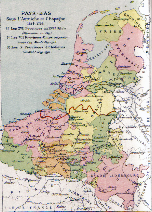
The Southern Netherlands, also called the Catholic Netherlands, were the parts of the Low Countries belonging to the Holy Roman Empire which were at first largely controlled by Habsburg Spain (Spanish Netherlands, 1556–1714) and later by the Austrian Habsburgs (Austrian Netherlands, 1714–1794) until occupied and annexed by Revolutionary France (1794–1815). The region also included a number of smaller states that were never ruled by Spain or Austria: the Prince-Bishopric of Liège, the Imperial Abbey of Stavelot-Malmedy, the County of Bouillon, the County of Horne and the Princely Abbey of Thorn. The Southern Netherlands comprised most of modern-day Belgium and Luxembourg, small parts of the modern Netherlands and Germany (the Upper Guelders region, as well as the Bitburg area in Germany, then part of Luxembourg), in addition to (until 1678) most of the present Nord-Pas-de-Calais region, and Longwy area in northern France. The (southern) Upper Guelders region consisted ... [...More Info...] [...Related Items...] OR: [Wikipedia] [Google] [Baidu] |
Battle Of Neerwinden (1793)
The Battle of Neerwinden (18 March 1793) saw a Republican French army led by Charles François Dumouriez attack a Coalition army commanded by Prince Josias of Saxe-Coburg-Saalfeld. The Coalition army of the Habsburg monarchy together with a small contingent of allied Dutch Republic troops repulsed all French assaults after bitter fighting and Dumouriez conceded defeat, withdrawing from the field. The French position in the Austrian Netherlands swiftly collapsed, ending the threat to the Dutch Republic and allowing Austria to regain control of its lost province. The War of the First Coalition engagement was fought at Neerwinden, located east of Brussels in present-day Belgium. After Dumouriez's victory at Jemappes in November 1792, the French armies rapidly overran most of the Austrian Netherlands. Rather than driving the Austrians to the west bank of the Rhine River, Dumouriez and the French government became preoccupied with a war with the Dutch Republic. During the breat ... [...More Info...] [...Related Items...] OR: [Wikipedia] [Google] [Baidu] |
Batavian Republic
The Batavian Republic ( nl, Bataafse Republiek; french: République Batave) was the successor state to the Republic of the Seven United Netherlands. It was proclaimed on 19 January 1795 and ended on 5 June 1806, with the accession of Louis Bonaparte to the Dutch throne. From October 1801 onward, it was known as the Batavian Commonwealth ( nl, Bataafs Gemenebest). Both names refer to the Germanic tribe of the ''Batavi'', representing both the Dutch ancestry and their ancient quest for liberty in their nationalistic lore. In early 1795, intervention by the French Republic led to the downfall of the old Dutch Republic. The new Republic enjoyed widespread support from the Dutch populace and was the product of a genuine popular revolution. However, it was founded with the armed support of the French revolutionary forces. The Batavian Republic became a client state, the first of the " sister-republics", and later part of the French Empire of Napoleon. Its politics were deeply in ... [...More Info...] [...Related Items...] OR: [Wikipedia] [Google] [Baidu] |
List Of Sovereign States
The following is a list providing an overview of sovereign states around the world with information on their status and recognition of their sovereignty. The 206 listed states can be divided into three categories based on membership within the United Nations System: 193 UN member states, 2 UN General Assembly non-member observer states, and 11 other states. The ''sovereignty dispute'' column indicates states having undisputed sovereignty (188 states, of which there are 187 UN member states and 1 UN General Assembly non-member observer state), states having disputed sovereignty (16 states, of which there are 6 UN member states, 1 UN General Assembly non-member observer state, and 9 de facto states), and states having a special political status (2 states, both in free association with New Zealand). Compiling a list such as this can be a complicated and controversial process, as there is no definition that is binding on all the members of the community of nations concerni ... [...More Info...] [...Related Items...] OR: [Wikipedia] [Google] [Baidu] |
Cabinet Of The Netherlands
The cabinet of the Netherlands ( nl, Nederlands kabinet) is the main executive body of the Netherlands. The current cabinet of the Netherlands is the Fourth Rutte cabinet, which has been in power since 10 January 2022. It is headed by Prime Minister Mark Rutte and his deputies Sigrid Kaag, Wopke Hoekstra and Carola Schouten. Composition and role The cabinet consists of the ministers and state secretaries. The cabinet is led by the Prime Minister. There are between twelve and sixteen Ministers, most of whom are also heads of specific government ministries, although there are often some ministers without portfolio who have areas of responsibility inside one or more ministries. For instance there has for some time been a minister for development cooperation, who works within the Ministry of Foreign Affairs. Most ministries also have a state secretary who is responsible for part of the relevant portfolio. State secretaries (such as that of Trade and Development Cooperation) are ... [...More Info...] [...Related Items...] OR: [Wikipedia] [Google] [Baidu] |


