|
Normalized Difference Red Edge Index
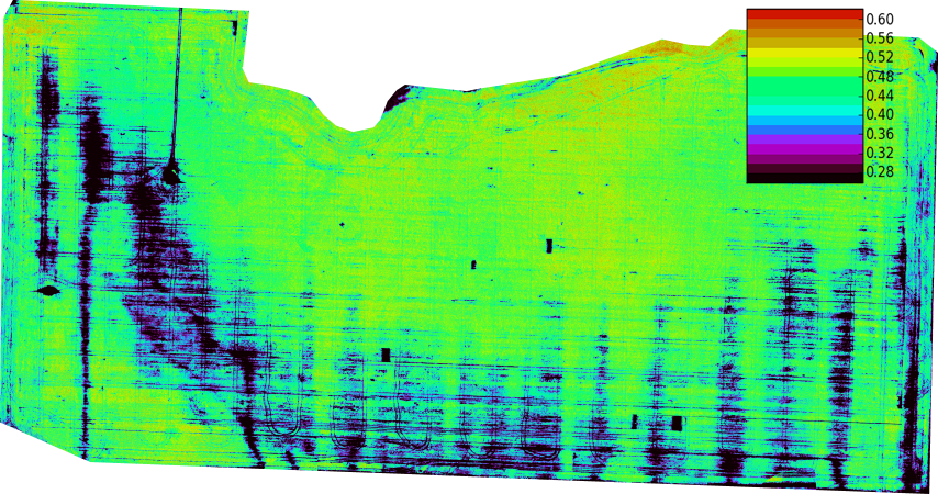
The normalized difference red edge index (NDRE) is a metric that can be used to analyse whether images obtained from multi-spectral image sensors contain healthy vegetation or not.Barnes, E. M., Clarke, T. R., Richards, S. E., Colaizzi, P. D., Haberland, J., Kostrzewski, M., ... & Lascano, R. J. (2000, July). Coincident detection of crop water stress, nitrogen status and canopy density using ground based multispectral data. In Proceedings of the Fifth International Conference on Precision Agriculture, Bloomington, MN, USA (Vol. 1619). https://naldc.nal.usda.gov/download/4190/PDF It is similar to Normalized Difference Vegetation Index (NDVI) but uses the ratio of Near-Infrared and the edge of Red as follows: :\mbox=\frac The red edge is the part of the spectrum centred around 715 nm. References External links Chlorophyll Absorption*Spectral Reflectance Changes Associated with Autumn Senescence of Aesculus hippocastanum L. and Acer platanoides L. Leaves. Spectral Featu ... [...More Info...] [...Related Items...] OR: [Wikipedia] [Google] [Baidu] |
Metric
Metric or metrical may refer to: * Metric system, an internationally adopted decimal system of measurement * An adjective indicating relation to measurement in general, or a noun describing a specific type of measurement Mathematics In mathematics, metric may refer to one of two related, but distinct concepts: * A function which measures distance between two points in a metric space * A metric tensor, in differential geometry, which allows defining lengths of curves, angles, and distances in a manifold Natural sciences * Metric tensor (general relativity), the fundamental object of study in general relativity, similar to the gravitational field in Newtonian physics * Senses related to measurement: ** Metric system, an internationally adopted decimal system of measurement ** Metric units, units related to a metric system ** International System of Units, or ''Système International'' (SI), the most widely used metric system * METRIC, a model that uses Landsat satellite dat ... [...More Info...] [...Related Items...] OR: [Wikipedia] [Google] [Baidu] |
Multispectral Image
Multispectral imaging captures image data within specific wavelength ranges across the electromagnetic spectrum. The wavelengths may be separated by filters or detected with the use of instruments that are sensitive to particular wavelengths, including light from frequencies beyond the visible light range, i.e. infrared and ultra-violet. It can allow extraction of additional information the human eye fails to capture with its visible receptors for red, green and blue. It was originally developed for military target identification and reconnaissance. Early space-based imaging platforms incorporated multispectral imaging technology to map details of the Earth related to coastal boundaries, vegetation, and landforms. Multispectral imaging has also found use in document and painting analysis. Multispectral imaging measures light in a small number (typically 3 to 15) of spectral bands. Hyperspectral imaging is a special case of spectral imaging where often hundreds of contig ... [...More Info...] [...Related Items...] OR: [Wikipedia] [Google] [Baidu] |
Vegetation
Vegetation is an assemblage of plant species and the ground cover they provide. It is a general term, without specific reference to particular taxa, life forms, structure, spatial extent, or any other specific botanical or geographic characteristics. It is broader than the term ''flora'' which refers to species composition. Perhaps the closest synonym is plant community, but ''vegetation'' can, and often does, refer to a wider range of spatial scales than that term does, including scales as large as the global. Primeval redwood forests, coastal mangrove stands, sphagnum bogs, desert soil crusts, roadside weed patches, wheat fields, cultivated gardens and lawns; all are encompassed by the term ''vegetation''. The vegetation type is defined by characteristic dominant species, or a common aspect of the assemblage, such as an elevation range or environmental commonality. The contemporary use of ''vegetation'' approximates that of ecologist Frederic Clements' term earth cov ... [...More Info...] [...Related Items...] OR: [Wikipedia] [Google] [Baidu] |
Normalized Difference Vegetation Index
The normalized difference vegetation index (NDVI) is a simple graphical indicator that can be used to analyze remote sensing measurements, often from a space platform, assessing whether or not the target being observed contains live green vegetation. Brief history The exploration of outer space started in earnest with the launch of Sputnik 1 by the Soviet Union on 4 October 1957. This was the first man-made satellite orbiting the Earth. Subsequent successful launches, both in the Soviet Union (e.g., the Sputnik and Cosmos programs), and in the U.S. (e.g., the Explorer program), quickly led to the design and operation of dedicated meteorological satellites. These are orbiting platforms embarking instruments specially designed to observe the Earth's atmosphere and surface with a view to improve weather forecasting. Starting in 1960, the TIROS series of satellites embarked television cameras and radiometers. This was later (1964 onwards) followed by the Nimbus satellites and ... [...More Info...] [...Related Items...] OR: [Wikipedia] [Google] [Baidu] |
Spectrum
A spectrum (plural ''spectra'' or ''spectrums'') is a condition that is not limited to a specific set of values but can vary, without gaps, across a continuum. The word was first used scientifically in optics to describe the rainbow of colors in visible light after passing through a prism. As scientific understanding of light advanced, it came to apply to the entire electromagnetic spectrum. It thereby became a mapping of a range of magnitudes (wavelengths) to a range of qualities, which are the perceived "colors of the rainbow" and other properties which correspond to wavelengths that lie outside of the visible light spectrum. Spectrum has since been applied by analogy to topics outside optics. Thus, one might talk about the " spectrum of political opinion", or the "spectrum of activity" of a drug, or the " autism spectrum". In these uses, values within a spectrum may not be associated with precisely quantifiable numbers or definitions. Such uses imply a broad range of co ... [...More Info...] [...Related Items...] OR: [Wikipedia] [Google] [Baidu] |
Satellite Meteorology
A weather satellite or meteorological satellite is a type of Earth observation satellite that is primarily used to monitor the weather and climate of the Earth. Satellites can be polar orbiting (covering the entire Earth asynchronously), or geostationary (hovering over the same spot on the equator). While primarily used to detect the development and movement of storm systems and other cloud patterns, meteorological satellites can also detect other phenomena such as city lights, fires, effects of pollution, auroras, sand and dust storms, snow cover, ice mapping, boundaries of ocean currents, and energy flows. Other types of environmental information are collected using weather satellites. Weather satellite images helped in monitoring the volcanic ash cloud from Mount St. Helens and activity from other volcanoes such as Mount Etna. Smoke from fires in the western United States such as Colorado and Utah have also been monitored. El Niño and its effects on weather are monitored ... [...More Info...] [...Related Items...] OR: [Wikipedia] [Google] [Baidu] |
Remote Sensing
Remote sensing is the acquisition of information about an object or phenomenon without making physical contact with the object, in contrast to in situ or on-site observation. The term is applied especially to acquiring information about Earth and other planets. Remote sensing is used in numerous fields, including geography, land surveying and most Earth science disciplines (e.g. hydrology, ecology, meteorology, oceanography, glaciology, geology); it also has military, intelligence, commercial, economic, planning, and humanitarian applications, among others. In current usage, the term ''remote sensing'' generally refers to the use of satellite- or aircraft-based sensor technologies to detect and classify objects on Earth. It includes the surface and the atmosphere and oceans, based on propagated signals (e.g. electromagnetic radiation). It may be split into "active" remote sensing (when a signal is emitted by a satellite or aircraft to the object and its reflection dete ... [...More Info...] [...Related Items...] OR: [Wikipedia] [Google] [Baidu] |


