|
Ngorongoro Highlands
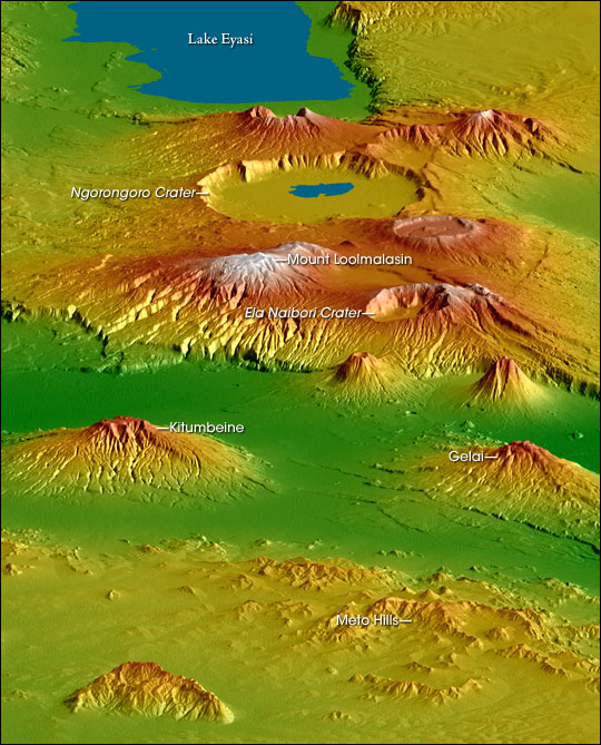
The Crater Highlands (Ngorongoro Highlands) are a geological region along the East African Rift in the Arusha Region Arusha City is a Tanzanian city and the regional capital of the Arusha Region, with a population of 416,442 plus 323,198 in the surrounding Arusha District Council (2012 census). Located below Mount Meru on the eastern edge of the eastern ... and parts of northern Manyara Region in north Tanzania. Geology The highlands are located in a spreading zone at the intersection of branches of two tectonic plates, the African Plate and Somali Plate, resulting in distinctive and prominent landforms. The highlands are named for the many Volcanic crater, craters and calderas present. As is common in spreading zones, volcanoes can be found here. Magma, rising to fill the gaps, reaches the surface and builds cones. Calderas form if a volcano explodes or collapses, following the emptying of the magma chamber below, and further spreading can fracture the volcanoes as ... [...More Info...] [...Related Items...] OR: [Wikipedia] [Google] [Baidu] |
Ela Naibori Crater
Ela or ELA may refer to: Companies and organizations * Basque Workers' Solidarity (Basque: '), a trade union * Earth Liberation Army * ELA Aviación, a Spanish aircraft manufacturer * English Lacrosse Association * Equatorial Launch Australia, owner-operator of Arnhem Space Centre in northern Australia * European Lift Association, a trade association * European Laser Association, see ''Lasers in Medical Science'' * European Labour Authority Music * ''E.L.A.'' (album), by Elastinen * "Ela" (Barrice song), by Barrice * ''Ela'' (Peggy Zina album), by Peggy Zina * "Ela" (Andromache song), by Andromache; Cyprus' song for the Eurovision Song Contest 2022 People * Ela (name), given name * Ela (surname) Places * East Los Angeles, California, United States * Eastside Los Angeles , United States * Ela (woreda), now Konta, Ethiopia * Ela, North Carolina, United States * Ela Beach, in Port Moresby, Papua New Guinea * Ela River, in New Hampshire, United States * Ela Township, Lake ... [...More Info...] [...Related Items...] OR: [Wikipedia] [Google] [Baidu] |
Highlands
Highland is a broad term for areas of higher elevation, such as a mountain range or mountainous plateau. Highland, Highlands, or The Highlands, may also refer to: Places Albania * Dukagjin Highlands Armenia * Armenian Highlands Australia *Southern Highlands (New South Wales), usually referred as the Southern Tablelands in New South Wales *Central Highlands (Victoria) *Central Highlands (Tasmania) *Northern Highlands, usually referred as the Northern Tablelands in New South Wales Brazil *Brazilian Highlands, the heartland of the country, located on the continental plateau Canada *Grey Highlands, a municipality in central Ontario near the Green Belt *Highlands, British Columbia, a municipality on Vancouver Island, British Columbia *Highlands, Edmonton, a residential neighbourhood in north east Edmonton, Alberta, Canada *Highlands, Newfoundland and Labrador, a settlement Iceland *Highlands of Iceland, cover most of the interior of Iceland Africa *Ethiopian Highlands, mountains ... [...More Info...] [...Related Items...] OR: [Wikipedia] [Google] [Baidu] |
Great Rift Valley
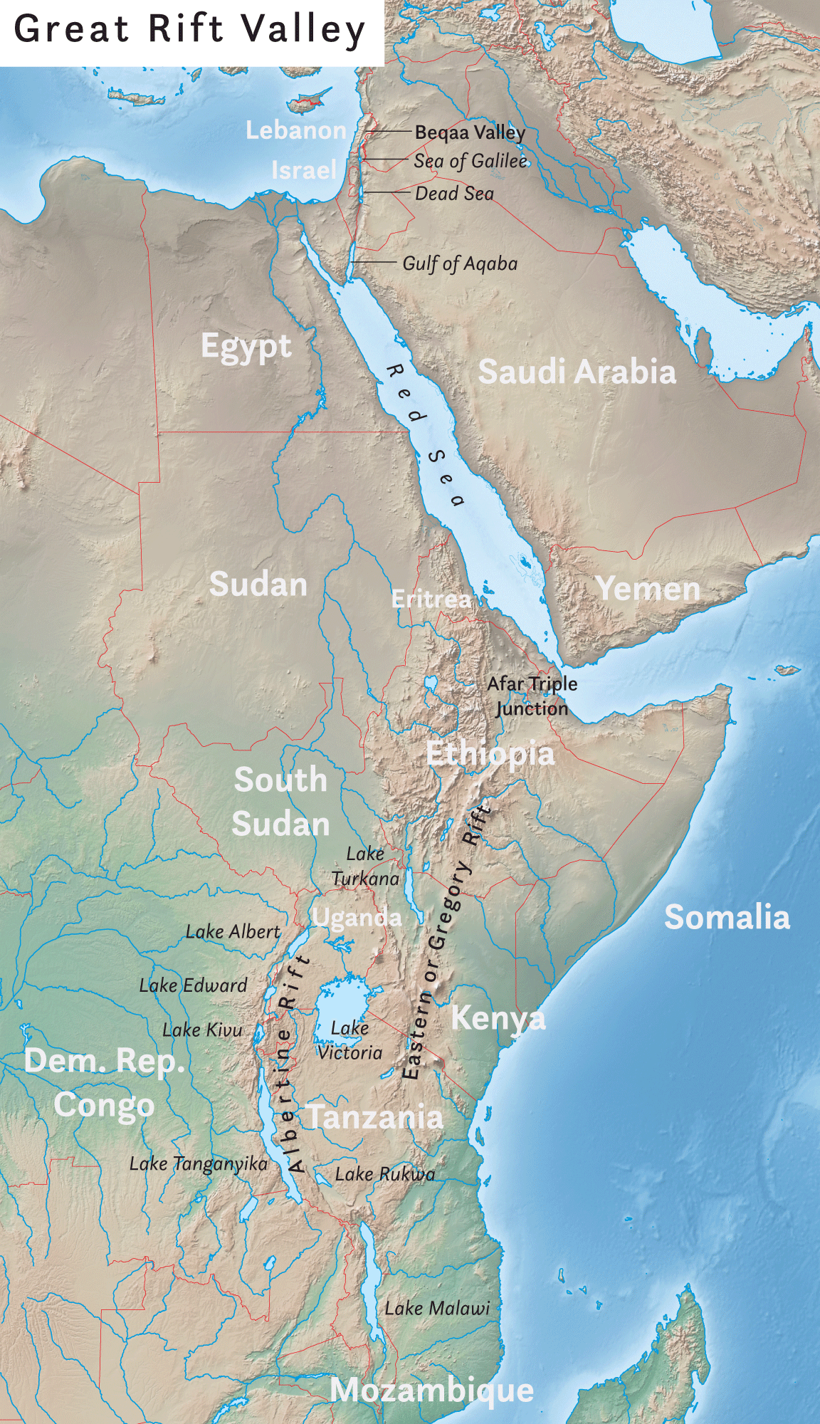
The Great Rift Valley is a series of contiguous geographic trenches, approximately in total length, that runs from Lebanon in Asia to Mozambique in Southeast Africa. While the name continues in some usages, it is rarely used in geology as it is considered an imprecise merging of separate though related rift and fault systems. This valley extends northward for 5,950 km through the eastern part of Africa, through the Red Sea, and into Western Asia. Several deep, elongated lakes, called ribbon lakes, exist on the floor of this rift valley: Lakes Malawi, Rudolf and Tanganyika are examples of such lakes. The region has a unique ecosystem and contains a number of Africa's wildlife parks. The term Great Rift Valley is most often used to refer to the valley of the East African Rift, the divergent plate boundary which extends from the Afar Triple Junction southward through eastern Africa, and is in the process of splitting the African Plate into two new and separate plates. Geologi ... [...More Info...] [...Related Items...] OR: [Wikipedia] [Google] [Baidu] |
Geology Of Tanzania
The geology of Tanzania began to form in the Precambrian, in the Archean and Proterozoic eons, in some cases more than 2.5 billion years ago. Igneous and metamorphic crystalline basement rock forms the Archean Tanzania Craton, which is surrounded by the Proterozoic Ubendian belt, Mozambique Belt and Karagwe-Ankole Belt. The region experienced downwarping of the crust during the Paleozoic and Mesozoic, as the massive Karoo Supergroup deposited. Within the past 100 million years, Tanzania has experienced marine sedimentary rock deposition along the coast and rift formation inland, which has produced large rift lakes. Tanzania has extensive, but poorly explored and exploited natural resources, including coal, gold, diamonds, graphite and clays. Stratigraphy & geologic history The oldest Precambrian rocks in Tanzania form the stable continental crust of the Tanzania Craton and date to the Archean more than 2.5 billion years ago. The craton includes the vestiges of two Archean orogenic b ... [...More Info...] [...Related Items...] OR: [Wikipedia] [Google] [Baidu] |
Geography Of Manyara Region
Geography (from Greek: , ''geographia''. Combination of Greek words ‘Geo’ (The Earth) and ‘Graphien’ (to describe), literally "earth description") is a field of science devoted to the study of the lands, features, inhabitants, and phenomena of Earth. The first recorded use of the word γεωγραφία was as a title of a book by Greek scholar Eratosthenes (276–194 BC). Geography is an all-encompassing discipline that seeks an understanding of Earth and its human and natural complexities—not merely where objects are, but also how they have changed and come to be. While geography is specific to Earth, many concepts can be applied more broadly to other celestial bodies in the field of planetary science. One such concept, the first law of geography, proposed by Waldo Tobler, is "everything is related to everything else, but near things are more related than distant things." Geography has been called "the world discipline" and "the bridge between the human and ... [...More Info...] [...Related Items...] OR: [Wikipedia] [Google] [Baidu] |
Geography Of Arusha Region
Geography (from Greek: , ''geographia''. Combination of Greek words ‘Geo’ (The Earth) and ‘Graphien’ (to describe), literally "earth description") is a field of science devoted to the study of the lands, features, inhabitants, and phenomena of Earth. The first recorded use of the word γεωγραφία was as a title of a book by Greek scholar Eratosthenes (276–194 BC). Geography is an all-encompassing discipline that seeks an understanding of Earth and its human and natural complexities—not merely where objects are, but also how they have changed and come to be. While geography is specific to Earth, many concepts can be applied more broadly to other celestial bodies in the field of planetary science. One such concept, the first law of geography, proposed by Waldo Tobler, is "everything is related to everything else, but near things are more related than distant things." Geography has been called "the world discipline" and "the bridge between the human and th ... [...More Info...] [...Related Items...] OR: [Wikipedia] [Google] [Baidu] |
Ngorongoro Conservation Area
The Ngorongoro Conservation Area (, ) is a protected area and a UNESCO World Heritage Site located in Ngorongoro District, west of Arusha City in Arusha Region, within the Crater Highlands geological area of northern Tanzania. The area is named after Ngorongoro Crater, a large volcanic caldera within the area. The Ngorongoro Conservation Area Authority administers the conservation area, an arm of the Tanzanian government, and its boundaries follow the boundary of the Ngorongoro District in Arusha Region. The western portion of the park abuts the Serengeti National Park (also a UNESCO World Heritage Site), and the area comprising the two parks and Kenya's Maasai Mara game reserve is home to Great Migration, a massive annual migration of millions of wildebeest, zebras, gazelles, and other animals. The conservation area also contains Olduvai Gorge, one of the most important paleoanthropological sites in the world. The 2009 Ngorongoro Wildlife Conservation Act placed new restri ... [...More Info...] [...Related Items...] OR: [Wikipedia] [Google] [Baidu] |
Ngorongoro Crater
The Ngorongoro Conservation Area (, ) is a protected area and a UNESCO World Heritage Site located in Ngorongoro District, west of Arusha City in Arusha Region, within the Crater Highlands geological area of northern Tanzania. The area is named after Ngorongoro Crater, a large volcanic caldera within the area. The Ngorongoro Conservation Area Authority administers the conservation area, an arm of the Tanzanian government, and its boundaries follow the boundary of the Ngorongoro District in Arusha Region. The western portion of the park abuts the Serengeti National Park (also a UNESCO World Heritage Site), and the area comprising the two parks and Kenya's Maasai Mara game reserve is home to Great Migration, a massive annual migration of millions of wildebeest, zebras, gazelles, and other animals. The conservation area also contains Olduvai Gorge, one of the most important paleoanthropological sites in the world. The 2009 Ngorongoro Wildlife Conservation Act placed new restri ... [...More Info...] [...Related Items...] OR: [Wikipedia] [Google] [Baidu] |
Mount Loolmalasin
Mount Loolmalasin (sometimes spelled "Loolmalassin") is a mountain located in the Ngorongoro District of the Arusha Region, Tanzania. It has a peak elevation of above sea level. It is, after Mount Kilimanjaro and Mount Meru (Tanzania), Mount Meru, the third-highest mountain in Tanzania if Kilimanjaro's three peaks are considered to be one mountain. Mount Loolmalasin is the second tallest mountain in Arusha Region and the tallest point in Ngorongoro District. The mountain also is the source of Simiyu River, which flows west to Lake Victoria in Simiyu Region. See also * List of Ultras of Africa References {{Reflist Mountains of Tanzania, Loolmalasin Geography of Arusha Region Ngorongoro District ... [...More Info...] [...Related Items...] OR: [Wikipedia] [Google] [Baidu] |
Lake Eyasi
Lake Eyasi (formerly german: Njarasasee, "Njarasa Lake", and ''Hohenlohesee'', "Hohenlohe Lake") is a lake located in Karatu District of Arusha Region in north Tanzania. Lake Eyasi is the largest body of water in Arusha region. It is a seasonal shallow endorheic salt lake on the floor of the Great Rift Valley at the base of the Serengeti Plateau, just south of the Serengeti National Park and immediately southwest of the Ngorongoro Crater in the Crater Highlands of Tanzania. The lake is elongated, orientated southwest to northeast, and lies in the Eyasi- Wembere branch of the Great Rift Valley. The principal inflow is the Sibiti River, which enters the southwestern end. The river may continue to flow somewhat year round, at least in wetter years; the other inflows are all seasonal. The second largest inflow is the Baray, at the northeast. The water carried by the Baray has increased in recent years due to deforestation of the Crater Highlands. The southwest flank of Mount Oldean ... [...More Info...] [...Related Items...] OR: [Wikipedia] [Google] [Baidu] |


.jpg)
