|
Great Rift Valley
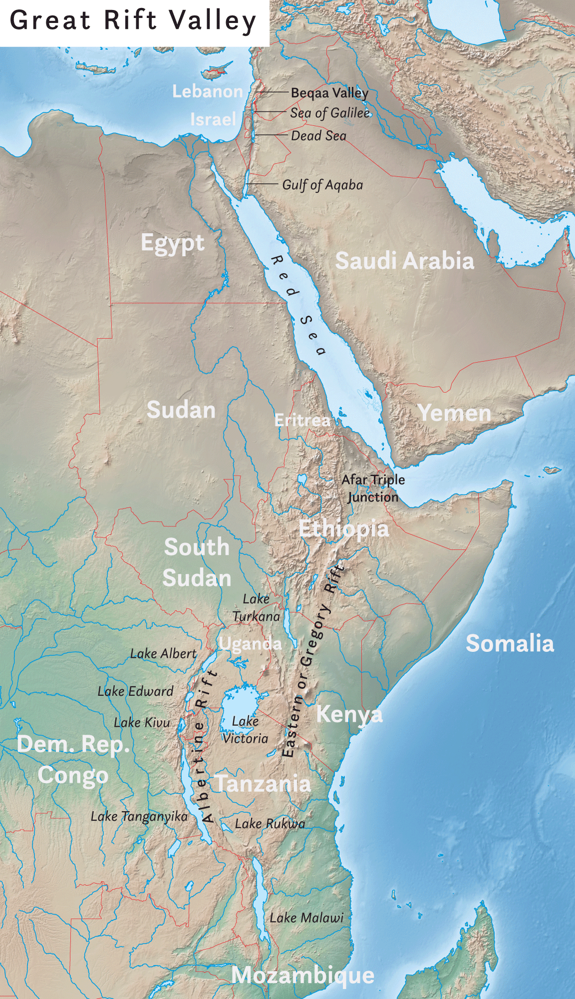
The Great Rift Valley is a series of contiguous geographic trenches, approximately in total length, that runs from Lebanon in Asia to Mozambique in Southeast Africa. While the name continues in some usages, it is rarely used in geology as it is considered an imprecise merging of separate though related rift and fault systems. This valley extends northward for 5,950 km through the eastern part of Africa, through the Red Sea, and into Western Asia. Several deep, elongated lakes, called ribbon lakes, exist on the floor of this rift valley: Lakes Malawi, Rudolf and Tanganyika are examples of such lakes. The region has a unique ecosystem and contains a number of Africa's wildlife parks. The term Great Rift Valley is most often used to refer to the valley of the East African Rift, the divergent plate boundary which extends from the Afar Triple Junction southward through eastern Africa, and is in the process of splitting the African Plate into two new and separate pla ... [...More Info...] [...Related Items...] OR: [Wikipedia] [Google] [Baidu] |
African Plate
The African Plate is a major tectonic plate that includes much of the continent of Africa (except for its easternmost part) and the adjacent oceanic crust to the west and south. It is bounded by the North American Plate and South American Plate to the west (separated by the Mid-Atlantic Ridge); the Arabian Plate and Somali Plate to the east; the Eurasian Plate, Aegean Sea Plate and Anatolian Plate to the north; and the Antarctic Plate to the south. Between and , the Somali Plate began rifting from the African Plate along the East African Rift. Since the continent of Africa consists of crust from both the African and the Somali plates, some literature refers to the African Plate as the Nubian Plate to distinguish it from the continent as a whole. Boundaries The western edge of the African Plate is a divergent boundary with the North American Plate to the north and the South American Plate to the south which forms the central and southern part of the Mid-Atlantic Ridge. The ... [...More Info...] [...Related Items...] OR: [Wikipedia] [Google] [Baidu] |
Hula Valley
The Hula Valley ( he, עמק החולה, Romanization of Hebrew, translit. ''Emek Ha-Ḥula''; also transliterated as Huleh Valley, ar, سهل الحولة) is an agriculture, agricultural region in northern Israel with abundant fresh water, which used to be Lake Hula, prior to its draining. It is a major stopover for birds migrating along the Syrian-African Rift Valley between Africa, Europe, and Asia. Lake Hula and the marshland surrounding it were a breeding ground for mosquitoes carrying malaria, and so were drained in the 1950s. A small section of the valley was later re-flooded in an attempt to revive a nearly extinct ecosystem. An estimated 500 million migrating birds now pass through the Hula Valley every year. Etymology Lake Hula was historically referred to by different names. The 14th century BCE Egyptians called the lake ''Samchuna'', while the Hebrew Bible records it as ''Merom''. In the 1st century CE, the Jewish-Roman historian Flavius Josephus termed it ''Seme ... [...More Info...] [...Related Items...] OR: [Wikipedia] [Google] [Baidu] |
Anti-Lebanon Mountains
The Anti-Lebanon Mountains ( ar, جبال لبنان الشرقية, Jibāl Lubnān ash-Sharqiyyah, Eastern Mountains of Lebanon; Lebanese Arabic: , , "Eastern Mountains") are a southwest–northeast-trending mountain range that forms most of the border between Syria and Lebanon. The border is largely defined along the crest of the range. Most of the range lies in Syria. Etymology Its Western name ''Anti-Lebanon'' comes from the Greek and Latin , derived from its position opposite (') and parallel to the Mount Lebanon range (). Geology The Anti-Lebanon range is approximately in length. To the south, the range adjoins the lower-lying Golan Heights plateau, but includes the highest peaks, namely Mount Hermon (''Jabal el-Shaykh'', in Arabic), at 2,814 metres, and Ta'la't Musa, at 2,669 metres. These peaks, on the Lebanese-Syrian border, are snow-covered for much of the year. Anti-Lebanon mountains are an anticline. Their predominant rocks are limestone and chalk from the Ju ... [...More Info...] [...Related Items...] OR: [Wikipedia] [Google] [Baidu] |
Mount Lebanon
Mount Lebanon ( ar, جَبَل لُبْنَان, ''jabal lubnān'', ; syr, ܛܘܪ ܠܒ݂ܢܢ, ', , ''ṭūr lewnōn'' french: Mont Liban) is a mountain range in Lebanon. It averages above in elevation, with its peak at . Geography The Mount Lebanon range extends along the entire country for about , parallel to the Mediterranean coast. Their highest peak is Qurnat as Sawda', at . The range receives a substantial amount of precipitation, including snow, which averages around deep.Jin and Krothe. ''Hydrogeology: Proceedings of the 30th International Geological Congress'', p. 170 Lebanon has historically been defined by the mountains, which provided protection for the local population. In Lebanon, changes in scenery are related less to geographical distances than to altitudes. The mountains were known for their oak and pine forests. The last remaining old growth groves of the famous Cedar of Lebanon (''Cedrus libani'' var. libanii'') are on the high slopes of Mount Lebanon, in ... [...More Info...] [...Related Items...] OR: [Wikipedia] [Google] [Baidu] |
Beqaa Valley
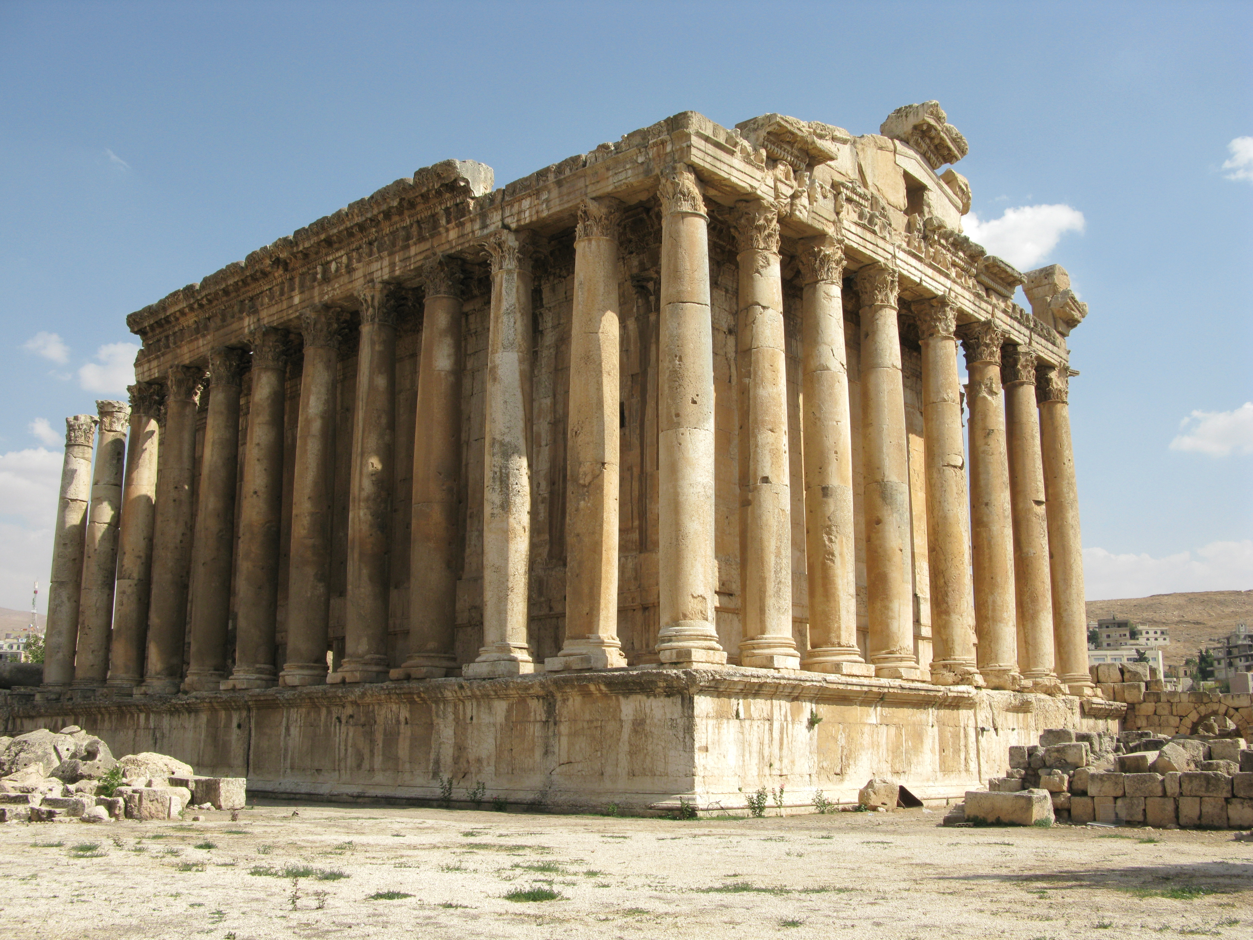
The Beqaa Valley ( ar, links=no, وادي البقاع, ', Lebanese ), also transliterated as Bekaa, Biqâ, and Becaa and known in classical antiquity as Coele-Syria, is a fertile valley in eastern Lebanon. It is Lebanon's most important farming region. Industry also flourishes in Beqaa, especially that related to agriculture. The Beqaa is located about east of Beirut. The valley is situated between Mount Lebanon to the west and the Anti-Lebanon Mountains to the east. It forms the northeasternmost extension of the Great Rift Valley, which stretches from Syria to the Red Sea. Beqaa Valley is long and wide on average. It has a Mediterranean climate of wet, often snowy winters and dry, warm summers. The region receives limited rainfall, particularly in the north, because Mount Lebanon creates a rain shadow that blocks precipitation coming from the sea. The northern section has an average annual rainfall of , compared to in the central valley. Nevertheless, two riv ... [...More Info...] [...Related Items...] OR: [Wikipedia] [Google] [Baidu] |
Red Sea Rift
The Red Sea Rift is a spreading center between two tectonic plates, the African Plate and the Arabian Plate. It extends from the Dead Sea Transform fault system, and ends at an intersection with the Aden Ridge and the East African Rift, forming the Afar Triple Junction in the Afar Depression of the Horn of Africa. The Red Sea Rift was formed by the divergence between the African Plate and the Arabian Plate. The rift transitioned from a continental rift to an oceanic rift. Magnetic anomalies suggest that the spreading rate on either side of the Red Sea is about 1 cm/year. The African plate has a rotation rate of 0.9270 degrees/ Ma, while the Arabian plate has a rotation rate of 1.1616 degrees/Ma. Spreading model A two-stage spreading model explains the tectonic evolution in this region. The first major rift motion was seen in the lower/middle Eocene, followed by major seafloor spreading in the late Eocene and early Oligocene. This was followed by a period of 30 Ma of n ... [...More Info...] [...Related Items...] OR: [Wikipedia] [Google] [Baidu] |
Jordan Rift Valley
The Jordan Rift Valley, also Jordan Valley ''Bīrʿāt haYardēn'', ar, الغور Al-Ghor or Al-Ghawr),, date=November 2022 also called the Syro-African Depression, is an elongated depression located in modern-day Israel, and Jordan. This geographic region includes the entire length of the Jordan River – from its sources, through the Hula Valley, the Korazim block, the Sea of Galilee, the (Lower) Jordan Valley, all the way to the Dead Sea, the lowest land elevation on Earth – and then continues through the Arabah depression, the Gulf of Aqaba whose shorelines it incorporates, until finally reaching the Red Sea proper at the Straits of Tiran. History and physical features The Jordan Rift Valley was formed many millions of years ago in the Miocene epoch (23.8 – 5.3 Myr ago) when the Arabian Plate moved northward and then eastward away from Africa. One million years later, the land between the Mediterranean and the Jordan Rift Valley rose so that the sea wate ... [...More Info...] [...Related Items...] OR: [Wikipedia] [Google] [Baidu] |
Dead Sea Transform
The Dead Sea Transform (DST) fault system, also sometimes referred to as the Dead Sea Rift, is a series of faults that run from the Maras Triple Junction (a junction with the East Anatolian Fault in southeastern Turkey) to the northern end of the Red Sea Rift (just offshore of the southern tip of the Sinai Peninsula). The fault system forms the transform boundary between the African Plate to the west and the Arabian Plate to the east. It is a zone of left lateral displacement, signifying the relative motions of the two plates. Both plates are moving in a general north-northeast direction, but the Arabian Plate is moving faster, resulting in the observed left lateral motions along the fault of approximately 107 km at its southern end. A component of extension is also present in the southern part of the transform, which has contributed to a series of depressions, or pull-apart basins, forming the Gulf of Aqaba, Dead Sea, Sea of Galilee, and Hula basins. A component of short ... [...More Info...] [...Related Items...] OR: [Wikipedia] [Google] [Baidu] |
East African Mountains
The East African mountains are a mountain region in the African Great Lakes, within Kenya, Uganda, Tanzania, Democratic Republic of the Congo, Rwanda and Burundi. Location and description The mountains are related to the East African Rift, and are in two chains, the Western Rift includes the Virunga Mountains, Mitumba Mountains, and the Rwenzori Range, while the mountains to the east include the largest peaks in Africa: the snow-covered Mount Kilimanjaro (5,895m, 19,340 ft), and Mount Kenya (5,199m, 17,058 ft). Other mountains in the Eastern Rift area include Mount Elgon in Kenya and Uganda. All but the Ruwenzori are of volcanic origin. The weather at the highest elevations is often cold and wet. Fauna The mountains are rich in wildlife, including animals who migrate to higher altitudes during the hot season in the surrounding savanna. The mountains are home to a number of endemic bird species such as Hinde's babbler which lives only on Mount Kenya. Threats and ... [...More Info...] [...Related Items...] OR: [Wikipedia] [Google] [Baidu] |


.jpg)
