|
Ngarnang
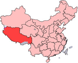
Ngarnang (Chinese: 阿朗; Pinyin: Ālǎng) is a village and township-level division of Lhünzhub County, in the Lhasa Prefecture of the Tibet Autonomous Region of China. See also *List of towns and villages in Tibet This is an alphabetical list of all populated places, including cities, towns and villages, in the Tibet Autonomous Region of western China. A *Alamdo *Alhar *Arza *Asog B * Baga *Bagar * Baidi *Baima * Baimai *Baixoi *Bamda *Banag *Ban ... Populated places in Lhasa (prefecture-level city) Township-level divisions of Tibet Lhünzhub County {{Tibet-geo-stub ... [...More Info...] [...Related Items...] OR: [Wikipedia] [Google] [Baidu] |
Township-level Divisions Of Tibet
This is a list of township-level divisions of Tibet Autonomous Region (TAR), People's Republic of China (PRC). After province, prefecture, and county-level divisions, township-level divisions constitute the formal fourth-level administrative divisions of the PRC. As of the end of 2014, there are a total of 691 such divisions in TAR, divided into 9 subdistricts, 140 towns, 534 townships, and 8 ethnic townships. Lhasa Chengguan District Subdistricts ( or ; Toinjoichu) * Caigungtang Subdistrict (; ), Chabxi Subdistrict (; ), Garmagoinsar Subdistrict (; ), Gündêling Subdistrict (; ), Gyirai Subdistrict (; ), Jêbumgang Subdistrict (; ), Jinzhu West Road Subdistrict (; ), Liangdao Subdistrict (; ), Ngaqên Subdistrict (; ), Nyangrain Subdistrict (; ), Pargor Subdistrict (; ), Togdê Subdistrict (; ) Doilungdêqên District Subdistricts * Donggar Subdistrict (, ), Naiqung Subdistrict (, ), Yabda Subdistrict (, ), Liuwu (Niu) Subdistrict (, ) Townships (; Xang) * ... [...More Info...] [...Related Items...] OR: [Wikipedia] [Google] [Baidu] |
Lhünzhub County
Lhünzhub County, also called Lhundrub or Linzhou County, is a county in Lhasa towards the north-east of the main center of Chengguan, Tibet, China. It covers an area of and as of 2000 had a population of 50,895 people, almost all classified as rural. The southern portion, the Pengbo River Valley, contains fertile arable land, while the colder and more mountainous northern portion primarily supports grazing. The county has many monasteries, including the Reting Monastery. Geography and climate Lhünzhub County is located in central Tibet around northeast of metropolitan Lhasa. It includes the Pengbo River Valley and the upper reaches of the Lhasa River. It covers an area of . The county is geologically complex, with an average elevation of . Mineral resources include lead, zinc, copper, silver, gold and gypsum. A spur of the Nyainqêntanglha mountains crosses the whole territory, dividing it into a southern and northern part. In the south the Pengbo valley has an average ... [...More Info...] [...Related Items...] OR: [Wikipedia] [Google] [Baidu] |
List Of Towns And Villages In Tibet
This is an alphabetical list of all populated places, including cities, towns and villages, in the Tibet Autonomous Region of western China. A *Alamdo *Alhar *Arza *Asog B *Baga, Tibet, Baga *Bagar *Baidi, Nagarzê County, Baidi *Baima *Baimai *Baixoi *Bamda *Banag *Banbar *Banggaidoi *Bangkor *Bangru *Bangxing *Baqên Town, Baqên *Bar *Bêba *Bei *Bênqungdo *Bilung *Birba *Biru Town, Biru *Bogkamba *Boindoi *Bolo, Gonjo County, Bolo *Bongba *Boqê *Bumgyê *Bungona’og *Bünsum *Burang Town, Burang *Bushêngcaka C *Caina Township, Caina *Cakaxiang *Camco *Cawarong *Cazê *Cêgnê *Cêngdo *Cêri *Cêrwai *Chabug *Chacang *Chagla *Chagna *Chagyoi *Cha’gyüngoinba *Chalükong *Chamco *Chamda *Chamoling *Changgo *Changlung *Changmar *Charing *Chatang *Chawola *Chêcang *Chênggo *Chepzi *Chibma *Chido *Chigu *Chongkü *Chongsar *Chowa *Chubalung *Chubarong *Chuka *Chumba *Chumbu *Chunduixiang *Co Nyi *Cocholung *Codoi, Tibet, Codoi *Cogo, Tibet, Cogo *Coka, Tibet, Co ... [...More Info...] [...Related Items...] OR: [Wikipedia] [Google] [Baidu] |
Chinese Character
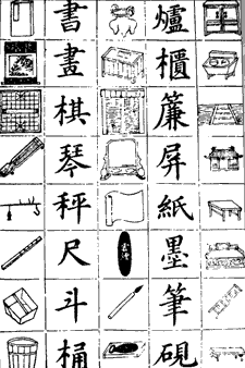
Chinese characters () are logograms developed for the Written Chinese, writing of Chinese. In addition, they have been adapted to write other East Asian languages, and remain a key component of the Japanese writing system where they are known as ''kanji''. Chinese characters in South Korea, which are known as ''hanja'', retain significant use in Korean academia to study its documents, history, literature and records. Vietnam once used the ''chữ Hán'' and developed chữ Nôm to write Vietnamese language, Vietnamese before turning to a Vietnamese alphabet, romanized alphabet. Chinese characters are the oldest continuously used system of writing in the world. By virtue of their widespread current use throughout East Asia and Southeast Asia, as well as their profound historic use throughout the adoption of Chinese literary culture, Sinosphere, Chinese characters are among the most widely adopted writing systems in the world by number of users. The total number of Chinese c ... [...More Info...] [...Related Items...] OR: [Wikipedia] [Google] [Baidu] |
Pinyin
Hanyu Pinyin (), often shortened to just pinyin, is the official romanization system for Standard Mandarin Chinese in China, and to some extent, in Singapore and Malaysia. It is often used to teach Mandarin, normally written in Chinese form, to learners already familiar with the Latin alphabet. The system includes four diacritics denoting tones, but pinyin without tone marks is used to spell Chinese names and words in languages written in the Latin script, and is also used in certain computer input methods to enter Chinese characters. The word ' () literally means "Han language" (i.e. Chinese language), while ' () means "spelled sounds". The pinyin system was developed in the 1950s by a group of Chinese linguists including Zhou Youguang and was based on earlier forms of romanizations of Chinese. It was published by the Chinese Government in 1958 and revised several times. The International Organization for Standardization (ISO) adopted pinyin as an international standard ... [...More Info...] [...Related Items...] OR: [Wikipedia] [Google] [Baidu] |
Lhasa Prefecture
Lhasa is a prefecture-level city, one of the main administrative divisions of the Tibet Autonomous Region of China. It covers an area of of rugged and sparsely populated terrain. Its capital and largest city is Lhasa, with around 300,000 residents, which mostly corresponds with the administrative Chengguan District, while its suburbs extend into Doilungdêqên District and Dagzê District. The consolidated prefecture-level city contains additional five, mostly rural, counties. The city boundaries roughly correspond to the basin of the Lhasa River, a major tributary of the Yarlung Tsangpo River. It lies on the Lhasa terrane, the last unit of crust to accrete to the Eurasian plate before the continent of India collided with Asia about 50 million years ago and pushed up the Himalayas. The terrain is high, contains a complex pattern of faults and is tectonically active. The temperature is generally warm in summer and rises above freezing on sunny days in winter. Most of the rai ... [...More Info...] [...Related Items...] OR: [Wikipedia] [Google] [Baidu] |
Tibet Autonomous Region
The Tibet Autonomous Region or Xizang Autonomous Region, often shortened to Tibet or Xizang, is a Provinces of China, province-level Autonomous regions of China, autonomous region of the China, People's Republic of China in Southwest China. It was overlayed on the traditional Tibetan regions of Ü-Tsang and Kham. It was formally established in 1965 to replace the Tibet Area (administrative division), Tibet Area, the former Administrative divisions of China, administrative division of the People's Republic of China (PRC) established after the annexation of Tibet by the People's Republic of China, annexation of Tibet. The establishment was about five years after the 1959 Tibetan uprising and the dismissal of the Kashag, and about 13 years after the original annexation. The current borders of the Tibet Autonomous Region were generally established in the 18th century and include about half of historic Tibet, or the Tibet, ethno-cultural Tibet. The Tibet Autonomous Region spans ov ... [...More Info...] [...Related Items...] OR: [Wikipedia] [Google] [Baidu] |
China
China, officially the People's Republic of China (PRC), is a country in East Asia. It is the world's most populous country, with a population exceeding 1.4 billion, slightly ahead of India. China spans the equivalent of five time zones and borders fourteen countries by land, the most of any country in the world, tied with Russia. Covering an area of approximately , it is the world's third largest country by total land area. The country consists of 22 provinces, five autonomous regions, four municipalities, and two Special Administrative Regions (Hong Kong and Macau). The national capital is Beijing, and the most populous city and financial center is Shanghai. Modern Chinese trace their origins to a cradle of civilization in the fertile basin of the Yellow River in the North China Plain. The semi-legendary Xia dynasty in the 21st century BCE and the well-attested Shang and Zhou dynasties developed a bureaucratic political system to serve hereditary monarchies, or dyna ... [...More Info...] [...Related Items...] OR: [Wikipedia] [Google] [Baidu] |
Populated Places In Lhasa (prefecture-level City)
Population typically refers to the number of people in a single area, whether it be a city or town, region, country, continent, or the world. Governments typically quantify the size of the resident population within their jurisdiction using a census, a process of collecting, analysing, compiling, and publishing data regarding a population. Perspectives of various disciplines Social sciences In sociology and population geography, population refers to a group of human beings with some predefined criterion in common, such as location, race, ethnicity, nationality, or religion. Demography is a social science which entails the statistical study of populations. Ecology In ecology, a population is a group of organisms of the same species who inhabit the same particular geographical area and are capable of interbreeding. The area of a sexual population is the area where inter-breeding is possible between any pair within the area and more probable than cross-breeding with ind ... [...More Info...] [...Related Items...] OR: [Wikipedia] [Google] [Baidu] |


.jpg)

